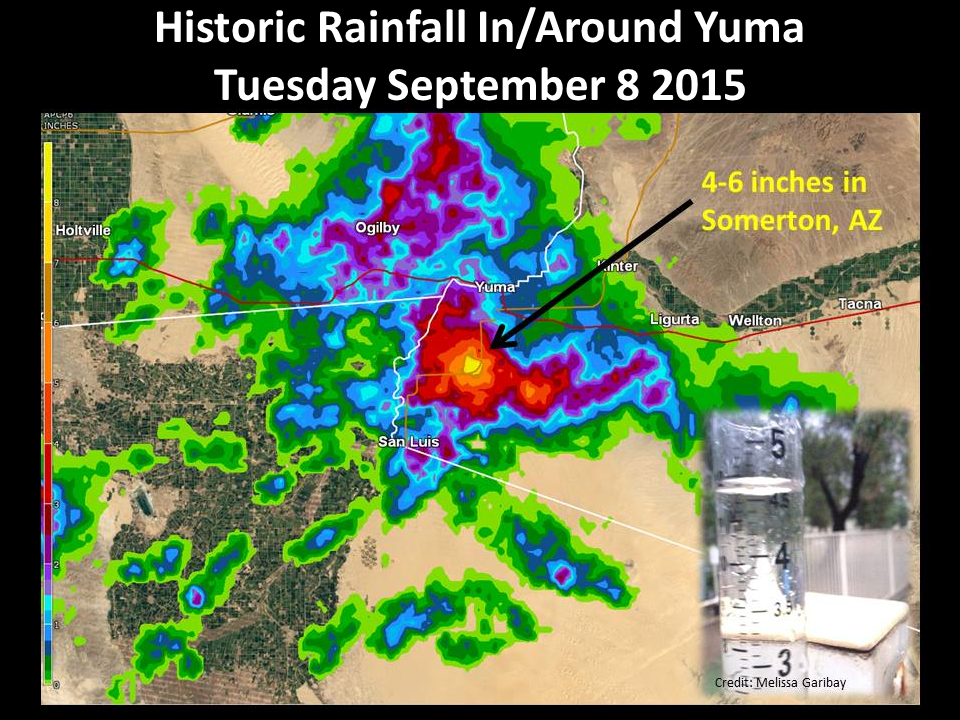
Several colliding outflow boundaries, combined with anomalously high atmospheric moisture associated with Hurricane Linda off the Baja Coast, resulted in shower and thunderstorm development around Yuma during the afternoon hours of Tuesday September 8. Initial hazards included blowing dust and damaging winds (including several downed trees in the Loma Vista Estates), however flooding quickly became the primary threat as storms trained (moved over the same area) for several hours.
As is typically the case during the monsoon, rainfall amounts varied across the region, with little rainfall to the east of Yuma, and tremendous amounts south of the airport near Somerton.
 |
 |
 |
|
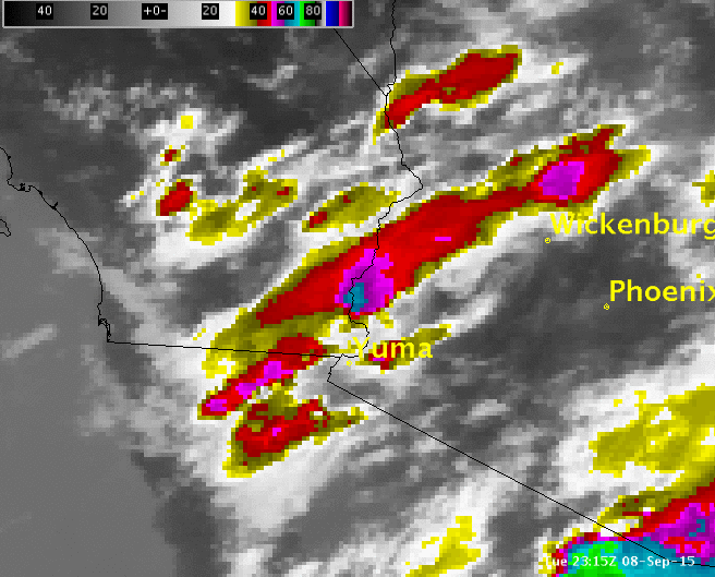
IR Satellite imagery showing the evolution of storms across the area. Loop from approximately 4-8pm Tue |
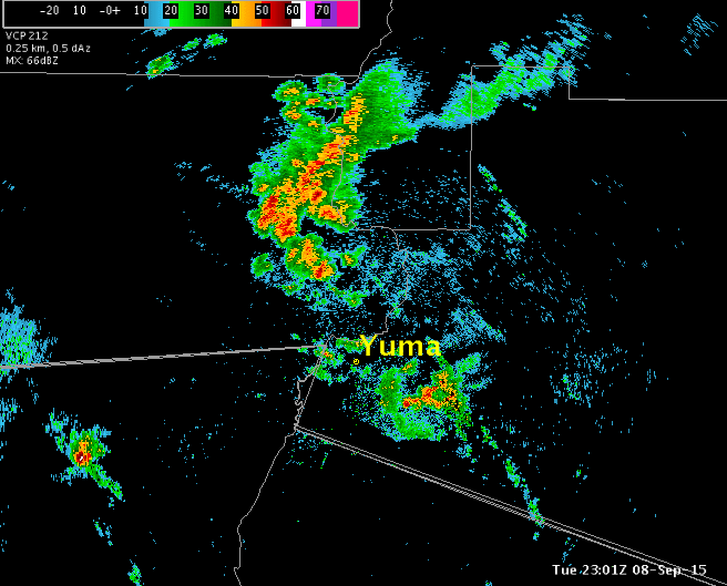
KYUX Base Reflectivity showing colliding outflow boundaries and quasi-stationary storms in/around Yuma. Loop from 4pm-8pm Tue. |
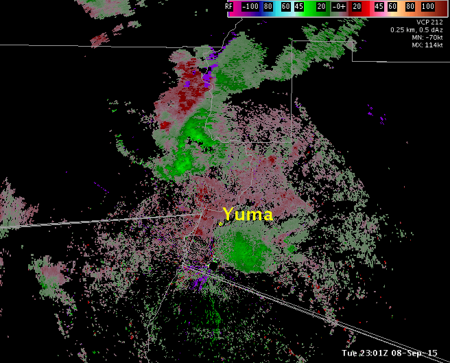
KYUX Base Velocity showing several colliding outflow boundaries along with a few downburst wind signatures near the radar. Loop from 4pm-8pm Tue. |
 |
 |
|
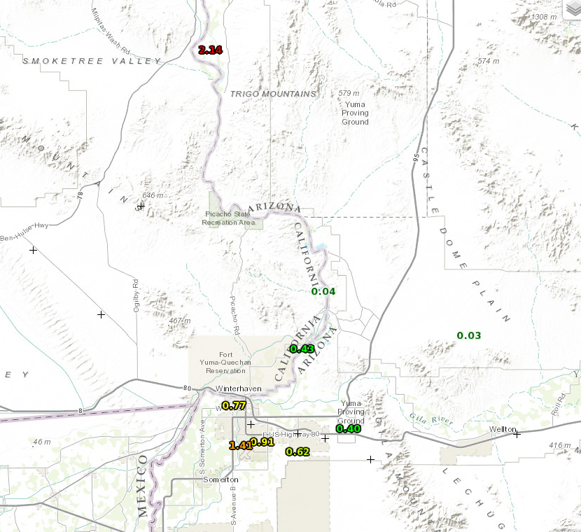
Storm total rainfall from several regional mesonet sites, including KNYL airport (0.91") and the Cibola RAWS (2.14"). Not shown: Somerton (4.6") |
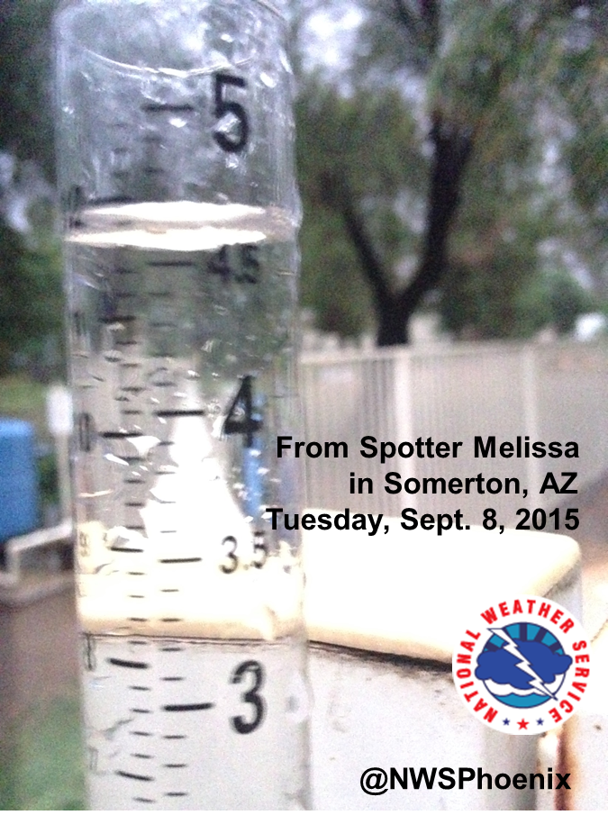
Storm total rainfall from Somerton, AZ. This gauge measured a total of 4.6", which closely matched KYUX radar estimates. Image courtesy Melissa Garibay |
 |
 |
 |
|
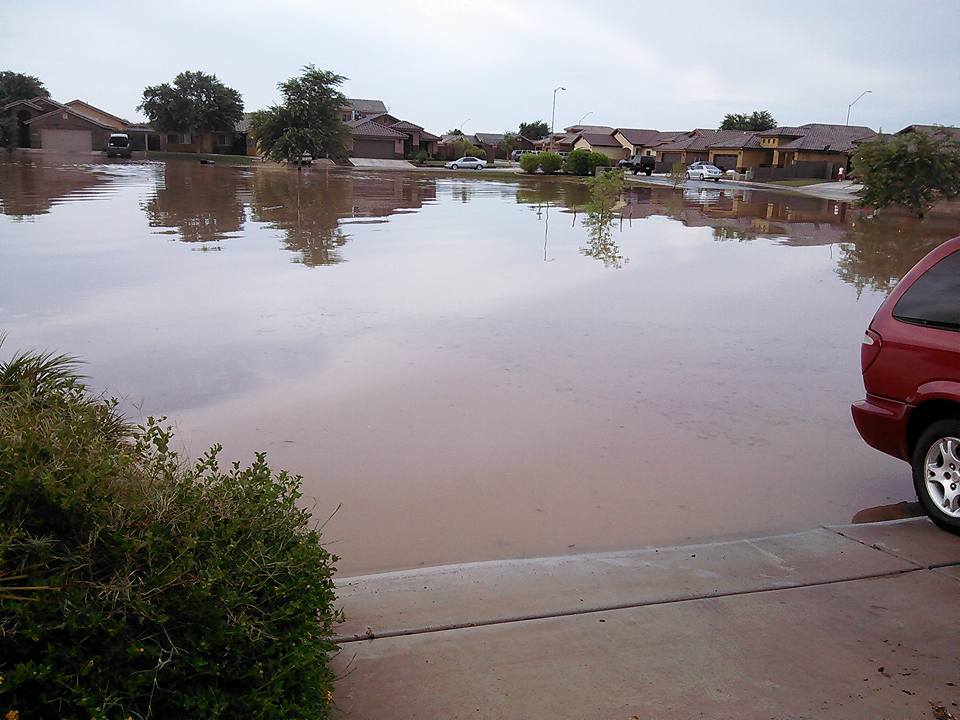
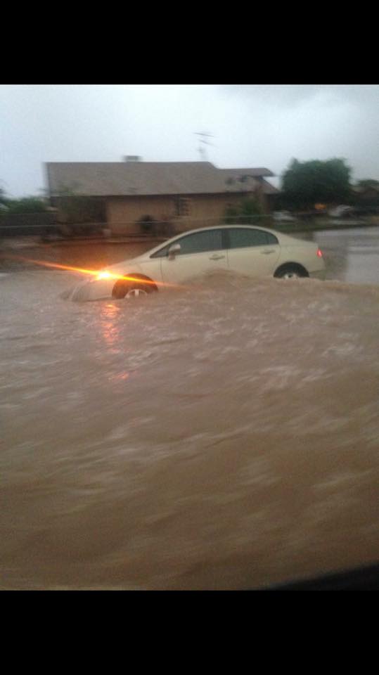
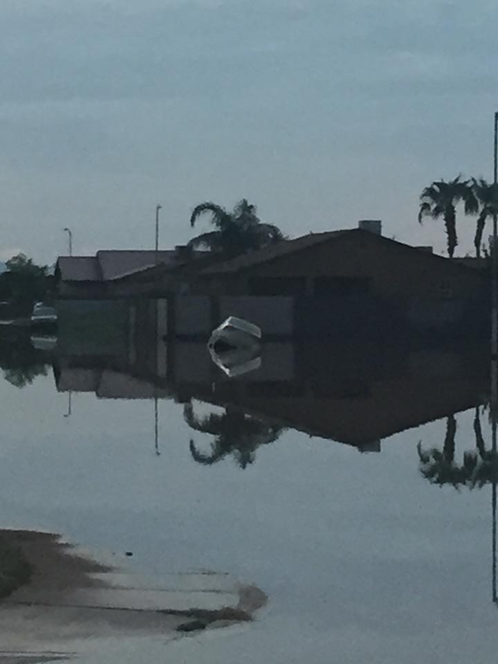
Flooded streets in Somerton. Image courtesy Berenice Carranza (via Facebook) |
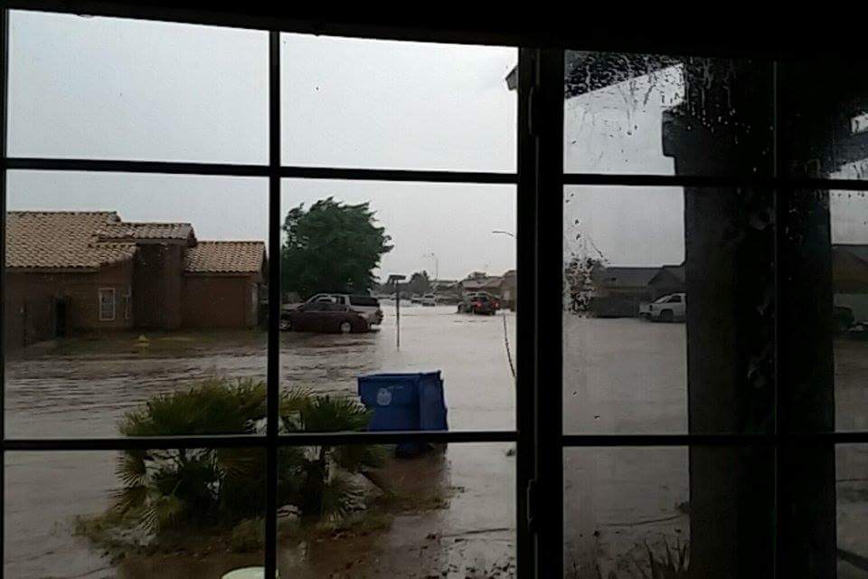
Flooded streets in Somerton. Image courtesy Anna Covarrubias (via Facebook) |
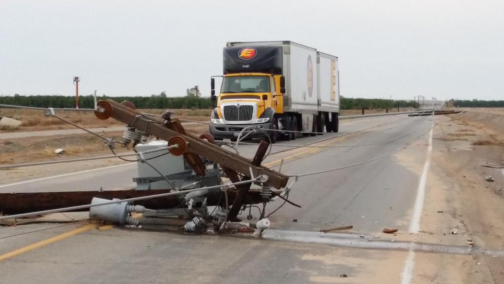
Downed power poles in Yuma. Image courtesy APS (via Twitter) |
 |
 |
 |
|
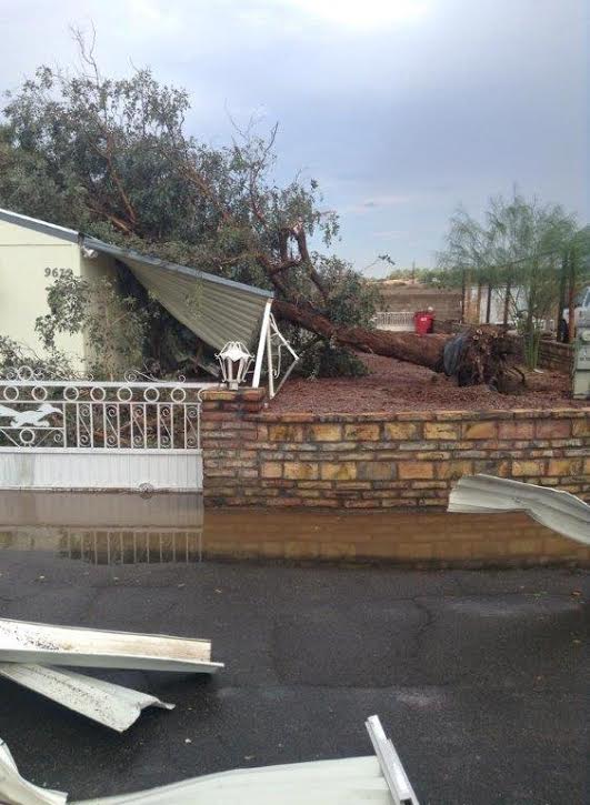
Tree damage in the Loma Vista Estates. Image courtesy KYMA TV |
Flooded streets in Somerton. Image courtesy Ricky Prieto (via Facebook) |
Flooded streets in Somerton. Image courtesy Ricky Prieto (via Facebook) |
...RECORD DAILY MAXIMUM RAINFALL SET AT YUMA AZ...

 A RECORD RAINFALL OF 0.91 INCH(ES) WAS SET AT YUMA AZ YESTERDAY.
THIS BREAKS THE OLD RECORD OF 0.19 SET IN 1896.
 ..TIME...   ...EVENT...      ...CITY LOCATION...     ...LAT.LON...
 ..DATE...   ....MAG....      ..COUNTY LOCATION..ST.. ...SOURCE....
             ..REMARKS..

 0400 PM     TSTM WND DMG     3 ENE ARABY             32.69N 114.47W
 09/08/2015                   YUMA               AZ   BROADCAST MEDIA

             LARGE TREE UPROOTED AND FELL ON HOUSE

 0435 PM     TSTM WND DMG     7 SSE YUMA              32.58N 114.58W
 09/08/2015                   YUMA               AZ   AMATEUR RADIO

             POWER POLES DOWN ON AVE 3E AND COUNTY 16 TO 19

 0435 PM     TSTM WND DMG     1 ESE YUMA              32.67N 114.60W
 09/08/2015                   YUMA               AZ   UTILITY COMPANY

             DELAYED REPORT...43 POWER POLES DOWN BETWEEN AVENUES 1E
             AND 3E.

 0611 PM     TSTM WND DMG     4 ESE SOMERTON          32.57N 114.66W
 09/08/2015                   YUMA               AZ   TRAINED SPOTTER

             PALM TREES DOWN. FRUIT TREE UPROOTED. 4 TO 6 INCH
             DIAMTER BRANCHES KNOCKED OFF OF TREES

 0700 PM     HEAVY RAIN       3 ENE SOMERTON          32.62N 114.66W
 09/08/2015  M4.60 INCH       YUMA               AZ   TRAINED SPOTTER

             4.60 INCHES OF RAIN IN 2 HOURS

 0800 PM     FLASH FLOOD      1 SE SOMERTON           32.59N 114.70W
 09/08/2015                   YUMA               AZ   BROADCAST MEDIA

             PEOPLE LEAVING FLOODED HOUSES SOUTH OF HIGHWAY 95
             BETWEEN JOSHUA ST. AND BINGHAM AVE.
PUBLIC INFORMATION STATEMENT
NATIONAL WEATHER SERVICE PHOENIX AZ
310 PM MST WED SEP 9 2015


...RAINFALL REPORTS PAST 24 HOURS ...

LOCATION                     AMOUNT    TIME/DATE

...ARIZONA...

...LA PAZ COUNTY...
3 SSW CIBOLA                 2.14 IN   0248 PM 09/09
2 NW WENDEN                  0.04 IN   0239 PM 09/09

...MARICOPA COUNTY...
ADOBE DAM   PCP-5535 OUTLET- 0.31 IN   1241 PM 09/09
2 E NORTH SCOTTSDALE         0.22 IN   0255 PM 09/09
HASSAYAMPA RIVER NR MORRISTO 0.17 IN   0230 PM 09/09
MORRISTOWN                   0.15 IN   0247 PM 09/09
INDIAN BEND WASH @ MCKELLIPS 0.12 IN   0929 AM 09/09
1 NNE SUN LAKES              0.07 IN   0300 PM 09/09
8 ESE CAREFREE               0.05 IN   0259 PM 09/09
1 ENE ARIZONA STATE UNIVERSI 0.05 IN   0254 PM 09/09
DEAD HORSE WASH              0.04 IN   0904 AM 09/09
MORRISTOWN                   0.04 IN   0218 PM 09/09
PRICE RD DRAIN- LOOP 101 & 2 0.04 IN   0123 PM 09/09
POWDER HOUSE WASH            0.03 IN   0101 PM 09/09
18 NE SENTINEL               0.02 IN   1000 AM 09/09
2 SW DEER VALLEY             0.01 IN   0225 PM 09/09
4 E AHWATUKEE FOOTHILLS      0.01 IN   0257 PM 09/09

...YUMA COUNTY...
FORT YUMA RAWS               1.41 IN   0216 PM 09/09
1 SSW WINTERHAVEN            0.82 IN   0300 PM 09/09
6 W FORTUNA FOOTHILLS        0.62 IN   0258 PM 09/09
COLORADO RIVER BL LAGUNA DAM 0.44 IN   0236 PM 09/09
1 NNW FORTUNA FOOTHILLS      0.40 IN   0300 PM 09/09
5 N DATELAND                 0.05 IN   0230 PM 09/09

...CALIFORNIA...

...IMPERIAL COUNTY...
4 ENE GORDON'S WELL          0.09 IN   0209 PM 09/09
4 S MARTINEZ LAKE            0.04 IN   0227 PM 09/09

...RIVERSIDE COUNTY...
1 NNE DESERT CENTER          0.04 IN   0258 PM 09/09

OBSERVATIONS ARE COLLECTED FROM A VARIETY OF SOURCES WITH VARYING
EQUIPMENT AND EXPOSURE. NOT ALL DATA LISTED ARE CONSIDERED OFFICIAL.

$$
|

