A nearly stationary area of low pressure over Baja California (the same weather system that played a role in the heavy rain across Phoenix two days prior), brought showers, thunderstorms, strong winds, and blowing dust to SW Arizona and SE California on Sunday, 9 September 2012. Early morning cloud cover rapidly dissipated before noon and sunny skies prevailed all the way into Sonora, Mexico. Storms initiated around 1 PM south of Rocky Point and moved northward into Arizona by 3 PM. Further intensification took place as the storms tracked along the international border toward Yuma, with the storms reaching their peak intensity as they arrived in Tacna and Fortuna Foothills.
The heaviest rainfall was localized in nature, very much unlike the event in Phoenix on 7 September. Rainfall totals were generally less than 1 inch, but was enough to cause at least one road closure due to flooding in SE California near Brawley.
 |
|
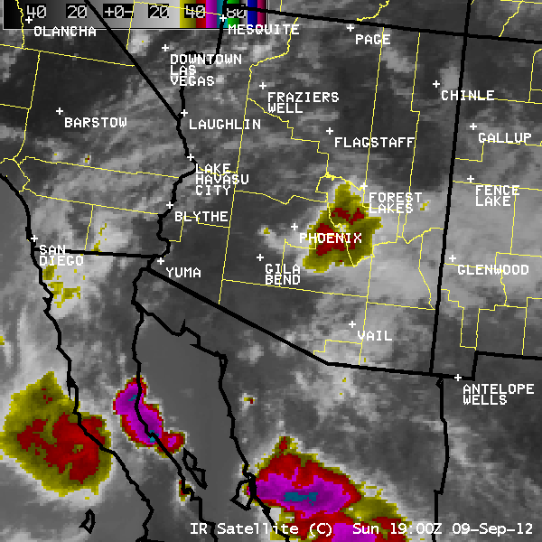
Infrared (IR) Satellite loop from 12 PM to 10 PM 9 September 2012. Pink/Blue colors indicate cold cloud tops (intensifying storms), while yellow/gray colors indicate warming cloud tops (weakening storms). The area of low pressure responsible for these storms is evident in the circulation noted over northern Baja California. |
 |
 |
|
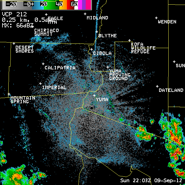
Yuma Radar imagery loop from 3 PM to 8 PM. Strongest storms are indicated with yellow and red colors. The two blue/green "arcs" seen moving from east to west through Yuma are areas of blowing dust. |
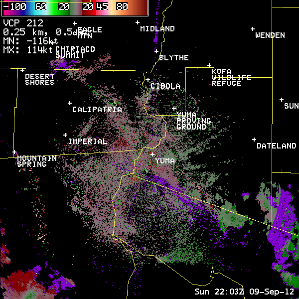
Yuma Radar Velocity loop from 3 PM to 8 PM. Strongest winds are indicated with bright green/blue colors (when storms are moving toward the radar), as well as bright red/pink colors (storms moving away from radar). Note the area of bright green/blue just southeast of Yuma (radar estimates of winds around 60kts). The Yuma airport (KNYL) recorded a gust of 65 mph winds shortly thereafter. Numerous other spotter reports confirmed winds around 65 mph at this time. |
 ..TIME...   ...EVENT...      ...CITY LOCATION...     ...LAT.LON...
 ..DATE...   ....MAG....      ..COUNTY LOCATION..ST.. ...SOURCE....
             ..REMARKS..

 0510 PM     TSTM WND DMG     7 E YUMA                32.68N 114.50W
 09/09/2012                   YUMA               AZ   AMATEUR RADIO

             POWER LINES DOWN.

 0515 PM     TSTM WND DMG     FORTUNA FOOTHILLS       32.66N 114.41W
 09/09/2012                   YUMA               AZ   TRAINED SPOTTER

             INTERSTATE 8 CLOSED FROM AVE 3E TO FOOTHILLS BLVD DUE
             TO DOWNED POWER LINES.

 0524 PM     TSTM WND GST     YUMA                    32.68N 114.62W
 09/09/2012  M58 MPH          YUMA               AZ   ASOS

 0530 PM     TSTM WND GST     2 NW YUMA               32.69N 114.64W
 09/09/2012  E65 MPH          YUMA               AZ   TRAINED SPOTTER

 0530 PM     TSTM WND DMG     4 ESE SOMERTON          32.57N 114.66W
 09/09/2012                   YUMA               AZ   TRAINED SPOTTER

             METAL SHED BLOWN 30 YARDS. 4 INCH TREE LIMBS BROKEN
             OFF.

 0532 PM     TSTM WND GST     YUMA                    32.68N 114.62W
 09/09/2012  M65 MPH          YUMA               AZ   ASOS

             YUMA AIRPORT

 0613 PM     HEAVY RAIN       4 ESE SOMERTON          32.57N 114.66W
 09/09/2012  M0.75 INCH       YUMA               AZ   TRAINED SPOTTER

             RAINFALL IN 40 MINUTES

 0845 PM     FLASH FLOOD      3 E BRAWLEY             32.98N 115.48W
 09/09/2012                   IMPERIAL           CA   LAW ENFORCEMENT

             HIGHWAY 78 CLOSED EAST OF BRAWLEY.

