Storm Report for August 18, 2021
Last updated at 2 PM on August 27, 2021
Impacts: Heavy rain with significant flash flooding
|
|
|
|
|
|
|
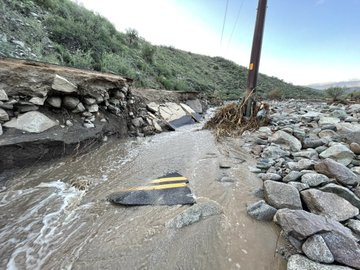
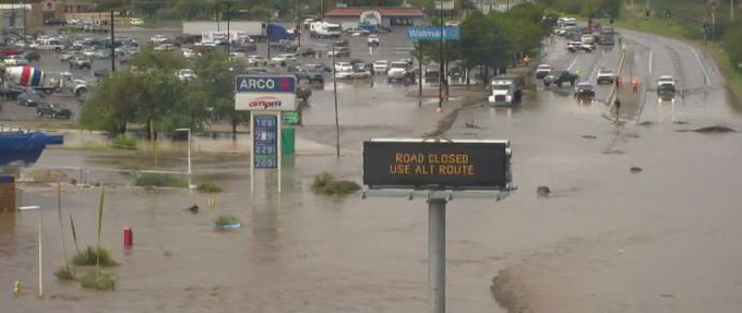
Fig. 1-3. Images of flooding in the Globe/Miami area. Catastrophic flooding occurred within the Russell Gulch drainage basin. Image sources (clockwise from top-left): one, two, three. |
|
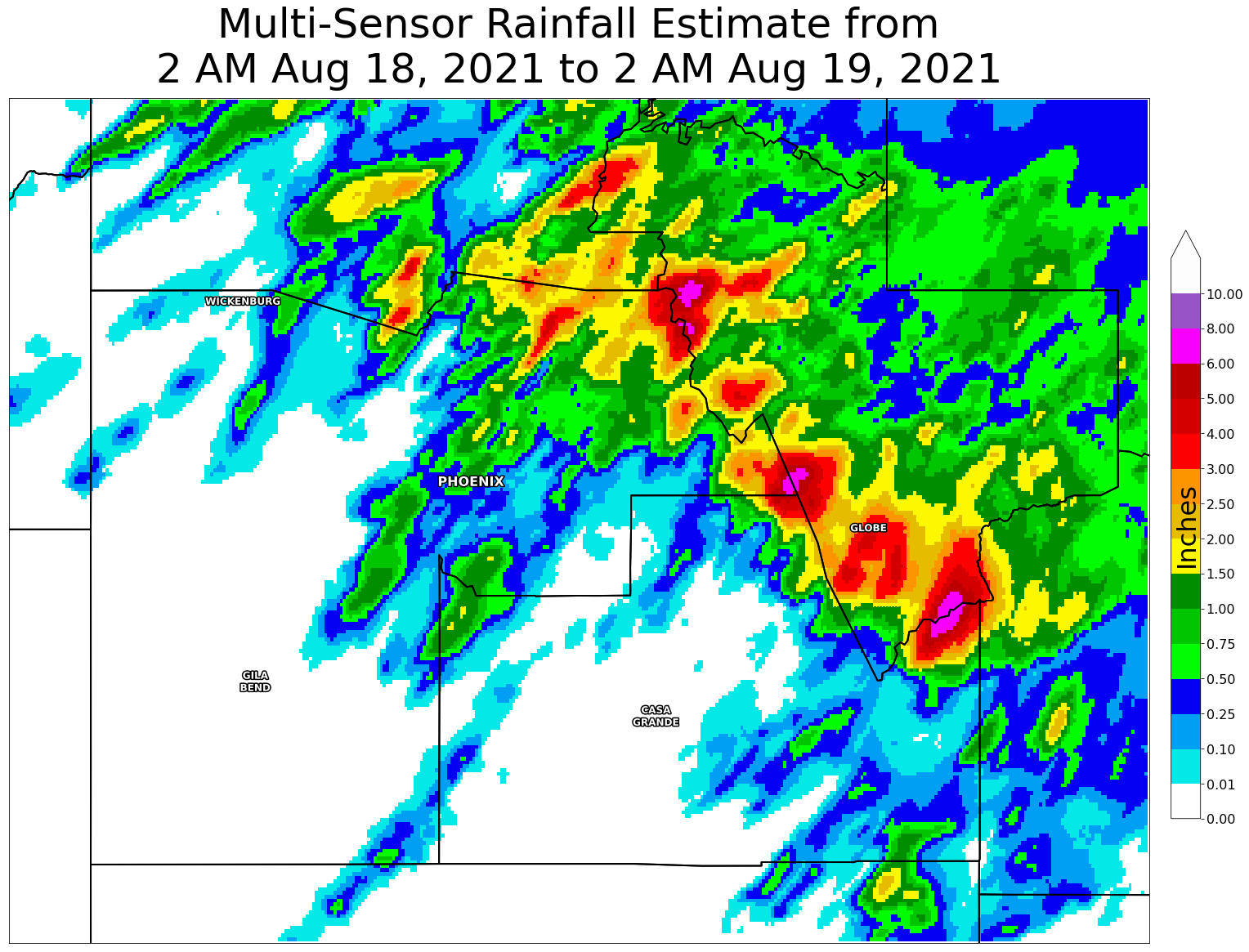
Showers and thunderstorms produced 1-3 inches of rainfall with pockets of 6+ inches focused on upslope and adjacent mountainous areas of northeast Maricopa, southeast Gila, and northeast Pinal counties. This included heavy rainfall (1.5 to 3 inches in two hours) south of Globe, AZ, over Pinal Peak and the Telegraph Burn Scar, which produced a significant response within area washes and canyons, including Russell Gulch, extending all the way into the City of Globe. Over 50 homes and structures were reported damaged by Gila County Emergency Management. U.S. Highway 60 near Globe was closed for several hours due to significant flooding. Per media reports, two fatalities occurred in Camp Creek when an ATV was caught in flood waters. Additional flooding occurred across the far northern reaches of the Phoenix metro area.
Fig. 4. Mosaic radar imagery from 12 AM on Aug. 18, 2021 to 4 AM on Aug. 19, 2021.
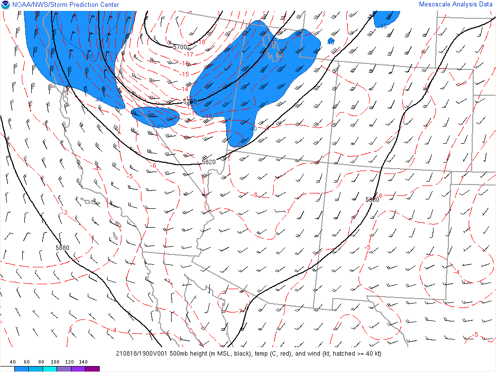
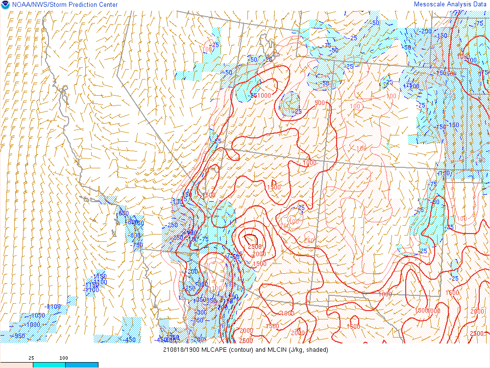
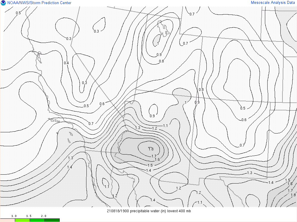
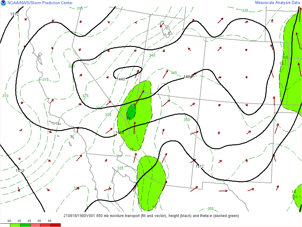
A very humid airmass remained over much of Arizona on Aug. 18, 2021. Precipitable water values (a measure of the amount of water vapor in the atmosphere) were highest across southern Arizona, with peak values near 1.8 inches (~95th percentile). Instability levels were moderate to high, with mixed layer convective available potential energy (MLCAPE, a measure of buoyancy for air near the ground) exceeding 2,000 J/kg. Concurrently, a trough was approaching from the northwest, causing an enhancement of southerly winds ahead of it. Caught in the southerly flow was another smaller upper level low which caused showers and thunderstorms to initiate as the low moved northward over Arizona. Additional waves of energy moving through, associated with the larger system to the northwest, caused periods of enhanced thunderstorm activity and thus higher rainfall amounts.
|
|
|
|
|
|
|
Fig. 5-8. Objective analysis fields at 12 PM on Aug. 18, 2021, of (clockwise from top-left): 500 mb heights and winds; mixed-layer convective available potential energy (MLCAPE); 850 mb heights, winds, theta-e and moisture transport; precipitable water. |
|
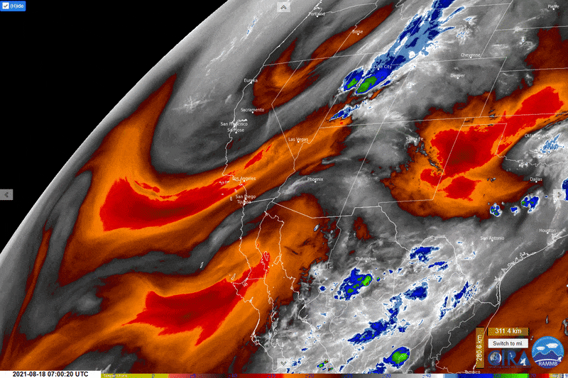
Fig. 9. GOES-16 mid-level water vapor imagery from 12 AM on Aug. 18, 2021 to 12 AM on Aug. 19, 2021. Note the larger upper level low (counter-clockwise swirl moving centered near Nevada) and smaller upper level low (counter-clockwise swirl traversing north Baja California into Arizona). Real-time data available here.
Given the unstable, moist air and southerly upslope flow, heavy rainfall was concentrated in the foothills and mountains of northeast Maricopa, southwest Gila, and far northern Pinal counties. A Flash Flood Watch was in effect during the event, with numerous short-term Flash Flood Warnings issued. Several areas received over four inches of rain, including the Pinal Mountains near Globe, AZ. This heavy rain fell on the Telegraph Burn Scar, causing catastrophic flooding within the Russell Gulch drainage basin.
Fig. 10. Rainfall estimates (based on gage-adjusted radar data from the Multi-Radar Multi-Sensor [MRMS] system) across southern Arizona from 2 AM on Aug. 18, 2021 to 2 AM on Aug. 19, 2021. Heavy rain of 1-4 inches fell along upslope areas of northeast Maricopa, southwest Gila, and northeast Pinal counties.
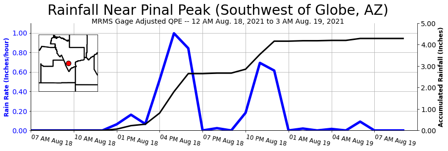
Fig. 11. Rainfall estimates (based on gage-adjusted radar data from the Multi-Radar Multi-Sensor [MRMS] system) for a point on Pinal Peak, just southwest of Globe, AZ, from 12 AM on Aug. 18, 2021 to 10 AM on Aug. 19, 2021. Over four inches of rain fell in this location, triggering catastrophic flooding near Globe.
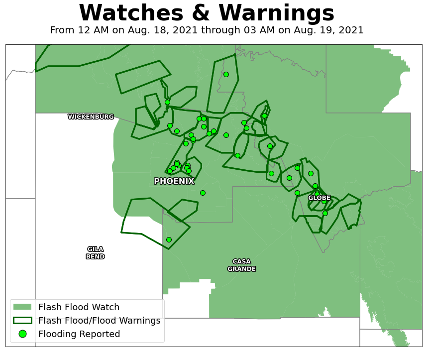
Fig. 12. Spatial extent of Flash Flood Watch and Flash Flood/Flood Warnings issued for this event by NWS offices in Phoenix, Flagstaff, and Tucson. Locations where flooding was reported to NWS noted with green dots.
During the afternoon hours, strong to severe thunderstorms developed across the Phoenix metropolitan area. Numerous Severe Thunderstorm Warnings were issued, with several reports received of wind damage and hail. Specific information can be found here.
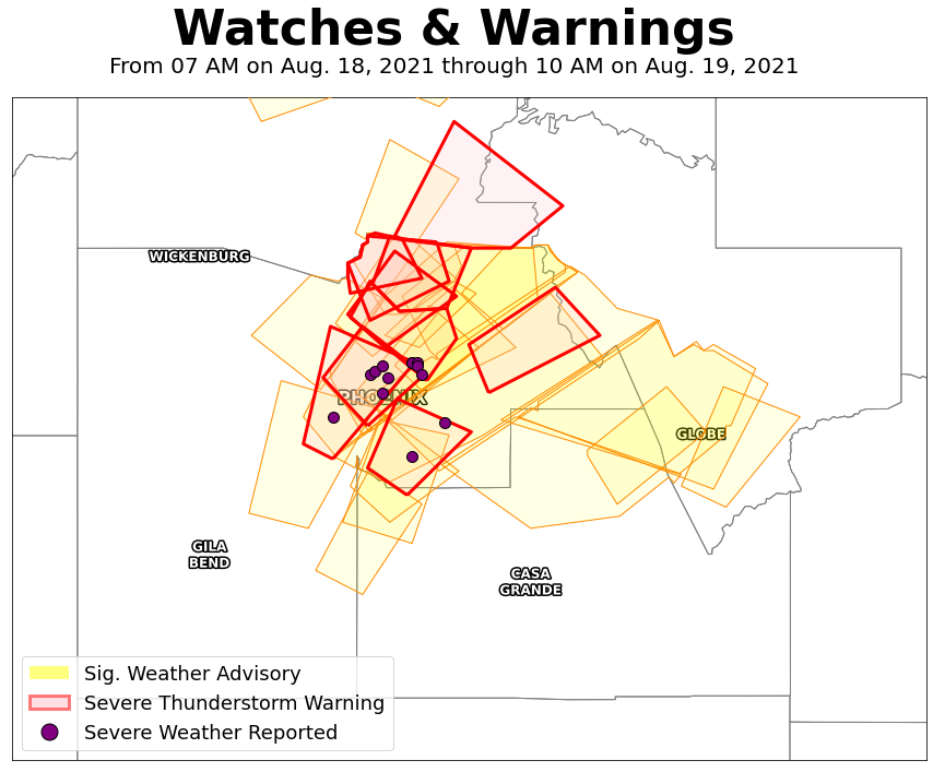
Fig. 13. Spatial extent of Significant Weather Advisories (40-58 mph winds, hail <1”) and Severe Thunderstorm Warnings (58+ mph winds, 1”+ hail) issued for this event by NWS offices in Phoenix, Flagstaff, and Tucson. Locations where severe weather was reported to NWS noted with purple dots.