Overview
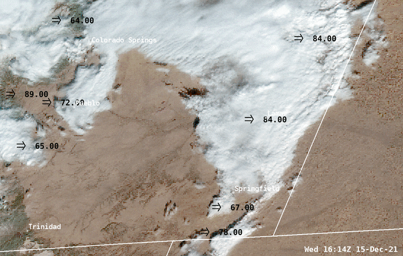 |
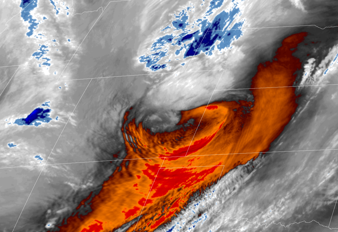
| GOES-East Geocolor revealing widespread blowing dust across southern Colorado. Courtesy Bill Line (Atmospheric Scientist; NOAA/ NESDIS) |
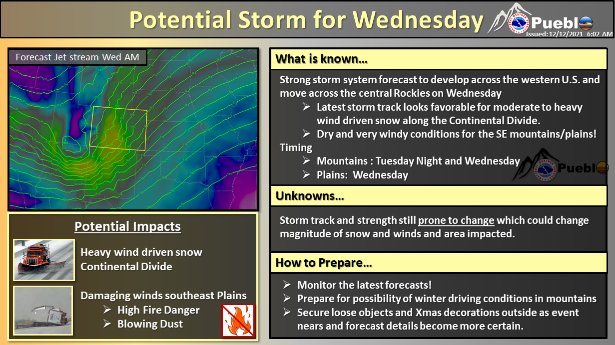
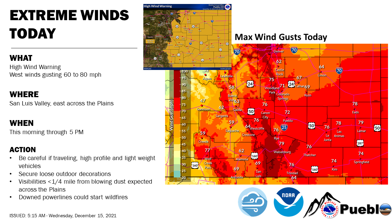
A major storm system moved across the region during the day on December 15th, providing widespread impacts to southern Colorado. Across southern Colorado, extreme winds, high to extreme fire danger, dust storms, heavy mountain snow, and snow squalls were all observed.
Storm Highlights:
107 MPH at Lamar at 844 AM MST
101 MPH at 2 SSW Manitou Springs 1156 AM MST
100 MPH at US Air Force Academy at 1118 AM MST
92 MPH at Colorado Springs Airport at 1254 PM MST
89 MPH at Pueblo Airport at 1016 AM MST
Environment
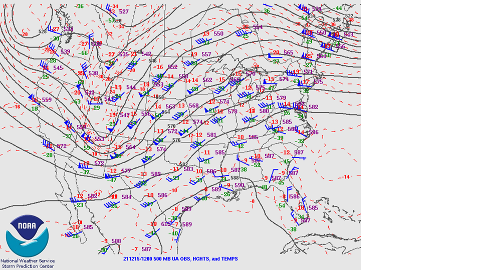
A potent upper level system and surface low approached the region late in the day on the 14th, and then lifted across Colorado during the day on the 15th as a strong upper level jet of 120 KT translated overhead.
This setup favored heavy mountain snow across the Continental Divide, primarily the eastern San Juan mountain. Meanwhile, lighter amounts of snow were observed across the central and eastern mountains. As this system pivoted across the region, the strength of this system and some weak instability supported the development of snow squalls from the Continental Divide east into parts of the I-25 corridor.
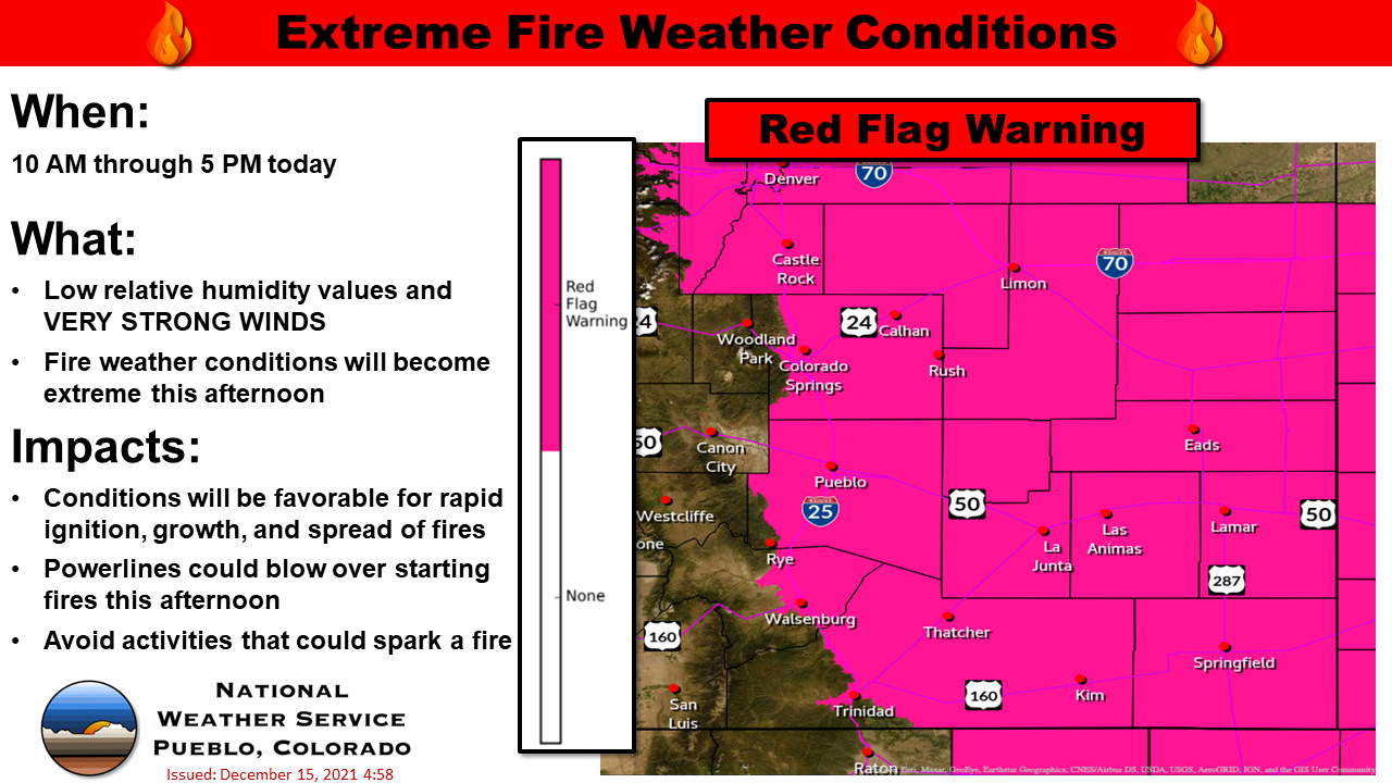
The strong jet moving across the region as well as mountain wave action produce widespread extreme winds over much of southern Colorado. The really dry conditions in place and these extreme winds then produced widespread blowing dust over much of the plains.
High/Extreme fire danger was also noted given the strength of the wind field and falling RH values, falling well into the teens
 |
 |
 |
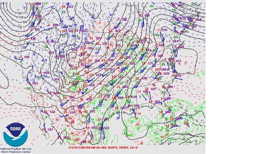 |
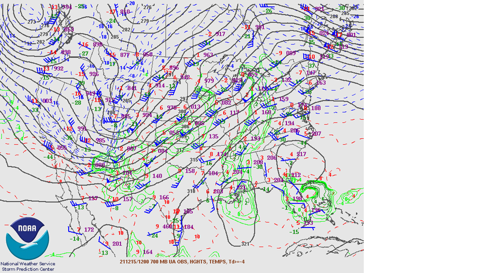
| 300mb Analysis from 5am on 12/15/2021 | 500mb Analysis from 5am on 12/15/2021 | 700mb Analysis from 5am on 12/15/2021 | 850mb Analysis from 5am on 12/15/2021 |
Near-storm environment summary.
 |
 |
 |
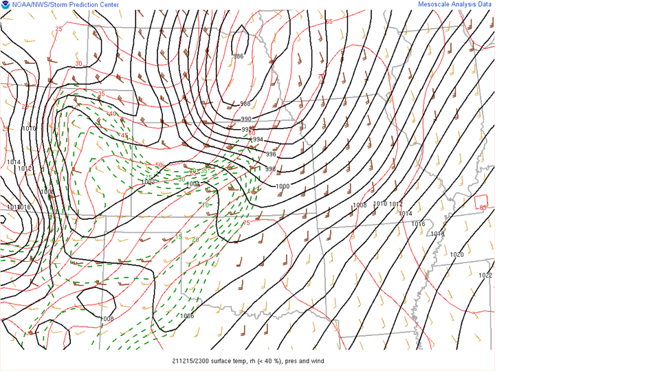 |
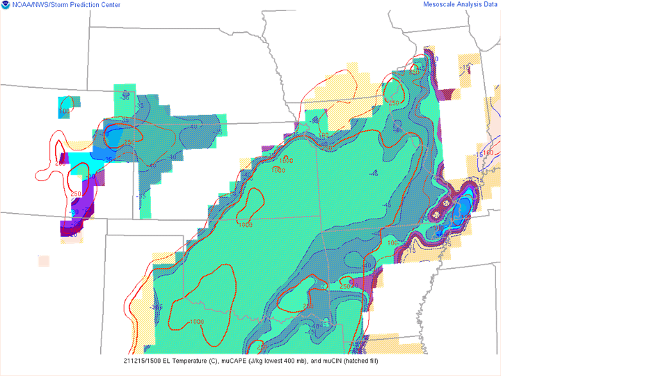
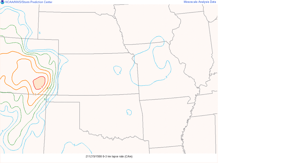
| MUCAPE and MUCIN over the plains at 7AM. | 0-3km Lapse Rates at 11AM. | Water Vapor Imagery illustrating dry air over the eastern plains. | Surface Temperatures, Relative Humidity, Pressure, and Wind, which highlights the High Fire Danger across the eastern plains. |
Service:
 |
 |
 |
 |
| Weather Story form 12/15/2021 | Weather Story from 12/15/2021 | Mesographic from 12/15/2021 at 9AM | Early Morning Mesographic from 12/15/2021 |
 |
| Weather Story form 12/15/2021 highlighting High Fire Danger |
Photos & Video
Still gathering photos:
| Caption (source) |
Caption (source) |
Caption (source) |
Caption (source) |
Radar
Header
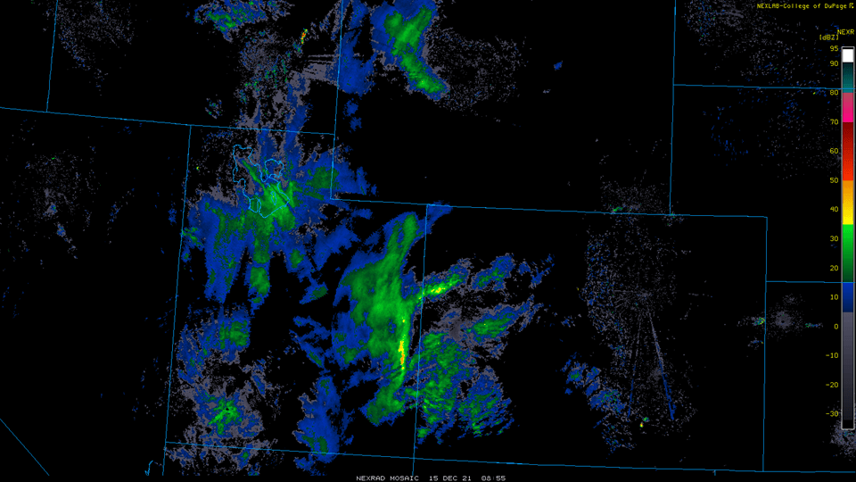 |
| Radar loop of the squall line that developed over Colorado on 12/15/2021. |
Storm Reports
PUBLIC INFORMATION STATEMENT
NATIONAL WEATHER SERVICE PUEBLO CO
714 PM MST WED DEC 15 2021

...HIGHEST WIND REPORTS...

LOCATION                     SPEED     TIME/DATE       LAT/LON
LAMAR AIRPORT                107 MPH   0844 AM 12/15   38.07N/102.68W
2 SSW MANITOU SPGS           101 MPH   1156 AM 12/15   38.83N/104.93W
US AIR FORCE ACADEMY         100 MPH   1118 AM 12/15   38.97N/104.82W
3 WSW AIR FORCE ACADEMY      94 MPH    1051 AM 12/15   38.99N/104.92W
COLORADO SPRINGS             93 MPH    1210 PM 12/15   38.93N/104.85W
5 NE MANITOU SPGS            93 MPH    1219 PM 12/15   38.92N/104.84W
025S146 GARDEN OF THE GODS   92 MPH    1046 AM 12/15   38.90N/104.83W
COLORADO SPRINGS             92 MPH    1131 AM 12/15   38.74N/104.86W
COLORADO SPRINGS AIRPORT     92 MPH    1254 PM 12/15   38.82N/104.68W
COLORADO SPRINGS             92 MPH    0201 PM 12/15   38.74N/104.86W
US AIR FORCE ACADEMY         91 MPH    1043 AM 12/15   38.97N/104.82W
US AIR FORCE ACADEMY         91 MPH    1058 AM 12/15   38.97N/104.82W
US AIR FORCE ACADEMY         91 MPH    1158 AM 12/15   38.97N/104.82W
COLORADO SPRINGS AIRPORT     91 MPH    1225 PM 12/15   38.82N/104.68W
WESTCLIFFE                   91 MPH    0748 AM 12/15   38.07N/105.53W
2 SSE PETERSON AFB           90 MPH    1218 PM 12/15   38.81N/104.69W
6 SSW WESTCLIFFE             90 MPH    0746 AM 12/15   38.05N/105.51W
WESTCLIFFE                   90 MPH    1058 AM 12/15   38.07N/105.53W
5 NE BLENDE                  89 MPH    1016 AM 12/15   38.29N/104.50W
1 SSW CANON CITY             89 MPH    0905 AM 12/15   38.44N/105.24W
025S146 GARDEN OF THE GODS   88 MPH    1036 AM 12/15   38.90N/104.83W
COLORADO SPRINGS             86 MPH    1220 PM 12/15   38.93N/104.85W
COLORADO SPRINGS             85 MPH    1210 PM 12/15   38.94N/104.78W
LAMAR AIRPORT                84 MPH    0855 AM 12/15   38.07N/102.68W
LA JUNTA AIRPORT             84 MPH    0810 AM 12/15   38.05N/103.52W
LA JUNTA AIRPORT             84 MPH    0822 AM 12/15   38.05N/103.52W
COLORADO SPRINGS             84 MPH    1100 AM 12/15   38.93N/104.85W
1 SE RAMPART RSVR            84 MPH    1235 PM 12/15   38.96N/104.95W
8 S SPRINGFIELD              84 MPH    0956 AM 12/15   37.28N/102.62W
COLORADO SPRINGS             82 MPH    1101 AM 12/15   38.74N/104.86W
5 NE MANITOU SPGS            82 MPH    1139 AM 12/15   38.92N/104.84W
UTE CANYON                   82 MPH    0959 AM 12/15   37.06N/102.63W
5 NE BLENDE                  81 MPH    1119 AM 12/15   38.29N/104.50W
LA JUNTA AIRPORT             81 MPH    1153 AM 12/15   38.05N/103.52W
5 NE MANITOU SPGS            81 MPH    1038 AM 12/15   38.92N/104.84W
5 NE MANITOU SPGS            81 MPH    1048 AM 12/15   38.92N/104.84W
COLORADO SPRINGS             81 MPH    1050 AM 12/15   38.93N/104.85W
COLORADO SPRINGS             81 MPH    1051 AM 12/15   38.74N/104.86W
2 SSW MANITOU SPGS           81 MPH    1124 AM 12/15   38.83N/104.93W
FT CARSON AIRPORT            81 MPH    1158 AM 12/15   38.67N/104.77W
5 NE MANITOU SPGS            81 MPH    1249 PM 12/15   38.92N/104.84W
5 NE MANITOU SPGS            81 MPH    0109 PM 12/15   38.92N/104.84W
COLORADO SPRINGS             81 MPH    0250 PM 12/15   38.93N/104.85W
025S05910RWS1RHS - 0.4 MI N  79 MPH    1056 AM 12/15   37.75N/104.84W
RED CREEK                    78 MPH    1058 AM 12/15   38.21N/105.00W
025S05910RWS1RHS - 0.4 MI N  78 MPH    0813 AM 12/15   37.75N/104.84W
BLACK MOUNTAIN               78 MPH    0156 PM 12/15   37.86N/105.28W
COLORADO SPRINGS             78 MPH    1041 AM 12/15   38.74N/104.86W
UTE CANYON                   78 MPH    0859 AM 12/15   37.06N/102.63W
ARVADA                       77 MPH    1020 AM 12/15   38.34N/104.82W
BIG HORN                     77 MPH    0558 AM 12/15   37.02N/106.20W
UTE CANYON                   77 MPH    1159 AM 12/15   37.06N/102.63W
5 NE BLENDE                  76 MPH    0715 AM 12/15   38.29N/104.50W
LA JUNTA AIRPORT             76 MPH    1053 AM 12/15   38.05N/103.52W
160W166 WOLF CREEK PASS      76 MPH    0418 AM 12/15   37.48N/106.78W
TRINIDAD AIRPORT             76 MPH    0954 AM 12/15   37.27N/104.33W
025S05910RWS1RHS - 0.4 MI N  76 MPH    0701 AM 12/15   37.75N/104.84W
BLACK MOUNTAIN               76 MPH    0856 AM 12/15   37.86N/105.28W
BLACK MOUNTAIN               76 MPH    0956 AM 12/15   37.86N/105.28W
FREMONT COUNTY ARPT          76 MPH    0955 AM 12/15   38.42N/105.10W
5 NE MANITOU SPGS            76 MPH    1008 AM 12/15   38.92N/104.84W
US AIR FORCE ACADEMY         76 MPH    1043 AM 12/15   38.97N/104.82W
ARVADA                       75 MPH    1010 AM 12/15   38.34N/104.82W
025S066 APACHE CITY          75 MPH    0813 AM 12/15   37.86N/104.83W
COLORADO SPRINGS             75 MPH    0950 AM 12/15   38.93N/104.85W
1 SE RAMPART RSVR            75 MPH    1135 AM 12/15   38.96N/104.95W
FT. CARSON                   75 MPH    1158 AM 12/15   38.61N/104.89W
WESTCLIFFE                   75 MPH    0908 AM 12/15   38.07N/105.53W
ARVADA                       74 MPH    1130 AM 12/15   38.34N/104.82W
LAMAR AIRPORT                74 MPH    1053 AM 12/15   38.07N/102.68W
BEAR CREEK                   74 MPH    0934 AM 12/15   38.44N/105.96W
BEAR CREEK                   74 MPH    1034 AM 12/15   38.44N/105.96W
COLORADO SPRINGS             74 MPH    1125 AM 12/15   38.92N/104.87W
FOUNATIN                     74 MPH    1155 AM 12/15   38.57N/104.70W
WESTCLIFFE                   74 MPH    1038 AM 12/15   38.07N/105.53W
COTTONWOOD PASS              74 MPH    0855 AM 12/15   38.78N/106.22W
BLACK MOUNTAIN               73 MPH    1056 AM 12/15   37.86N/105.28W
ARVADA                       72 MPH    0900 AM 12/15   38.34N/104.82W
025S066 APACHE CITY          72 MPH    0722 AM 12/15   37.86N/104.83W
025S066 APACHE CITY          72 MPH    1025 AM 12/15   37.86N/104.83W
COLORADO SPRINGS             72 MPH    1031 AM 12/15   38.74N/104.86W
2 SSW MANITOU SPGS           72 MPH    1032 AM 12/15   38.83N/104.93W
COLORADO SPRINGS             72 MPH    1055 AM 12/15   38.92N/104.87W
FT. CARSON                   72 MPH    1058 AM 12/15   38.61N/104.89W
5 S BLACK FOREST             72 MPH    1232 PM 12/15   38.95N/104.71W
5 NE BLENDE                  71 MPH    0922 AM 12/15   38.29N/104.50W
287N055 GOBBLERS KNOB        71 MPH    1116 AM 12/15   37.75N/102.60W
GRANADA                      71 MPH    0106 PM 12/15   38.06N/102.30W
TRINIDAD AIRPORT             71 MPH    0729 AM 12/15   37.27N/104.33W
COLORADO SPRINGS             71 MPH    1125 AM 12/15   38.94N/104.78W
160W278 LA VETA PASS         71 MPH    0934 AM 12/15   37.62N/105.19W
BIG HORN                     71 MPH    0758 AM 12/15   37.02N/106.20W
COTTONWOOD PASS              70 MPH    0935 AM 12/15   38.78N/106.22W
8 S SPRINGFIELD              70 MPH    0956 AM 12/15   37.28N/102.62W
WESTCLIFFE                   69 MPH    0738 AM 12/15   38.07N/105.53W
MANCHESTER                   68 MPH    1154 AM 12/15   39.11N/105.14W
BOSQUE                       68 MPH    0826 AM 12/15   37.09N/104.92W
050E290 PENROSE              68 MPH    1036 AM 12/15   38.42N/105.04W
FOUNATIN                     68 MPH    1046 AM 12/15   38.57N/104.70W
COLORADO SPRINGS             68 MPH    0240 PM 12/15   38.93N/104.85W
160W278 LA VETA PASS         68 MPH    0914 AM 12/15   37.62N/105.19W
ALAMOSA AIRPORT              68 MPH    0609 AM 12/15   37.43N/105.87W
RED CREEK                    67 MPH    0758 AM 12/15   38.21N/105.00W
LAMAR                        67 MPH    1135 AM 12/15   38.08N/102.62W
LA JUNTA AIRPORT             67 MPH    0953 AM 12/15   38.05N/103.52W
025N033 AGUILAR              67 MPH    0712 AM 12/15   37.42N/104.63W
PINION CANYON                67 MPH    1223 PM 12/15   37.54N/104.03W
COLORADO SPRINGS AIRPORT     67 MPH    1054 AM 12/15   38.82N/104.68W
FT CARSON AIRPORT            67 MPH    1110 AM 12/15   38.67N/104.77W
COTTONWOOD PASS              67 MPH    0155 PM 12/15   38.78N/106.22W
8 S SPRINGFIELD              67 MPH    0856 AM 12/15   37.28N/102.62W
025N033 AGUILAR              66 MPH    1228 PM 12/15   37.42N/104.63W
5 NE MANITOU SPGS            66 MPH    0948 AM 12/15   38.92N/104.84W
WALSH                        66 MPH    0918 AM 12/15   37.27N/102.13W
FLORISSANT                   65 MPH    0755 AM 12/15   38.95N/105.27W
5 NE BLENDE                  65 MPH    0724 AM 12/15   38.30N/104.50W
COLORADO CITY                65 MPH    0857 AM 12/15   37.95N/104.87W
BOSQUE                       65 MPH    0926 AM 12/15   37.09N/104.92W
PINION CANYON                65 MPH    1123 AM 12/15   37.54N/104.03W
RYE                          65 MPH    0830 AM 12/15   37.83N/104.94W
025S05910RWS1RHS - 0.4 MI N  65 MPH    1046 AM 12/15   37.75N/104.84W
WALSH                        65 MPH    0928 AM 12/15   37.27N/102.13W
MANCHESTER                   64 MPH    0854 AM 12/15   39.11N/105.14W
HOLLY NO. 2                  64 MPH    1235 PM 12/15   38.14N/102.24W
025N033 AGUILAR              64 MPH    0934 AM 12/15   37.42N/104.63W
050E290 PENROSE              64 MPH    0955 AM 12/15   38.42N/105.04W
COLORADO SPRINGS             64 MPH    1010 AM 12/15   38.93N/104.85W
ALAMOSA                      64 MPH    0607 AM 12/15   37.48N/105.94W
1 SSE PUEBLO WEST            63 MPH    0903 AM 12/15   38.30N/104.75W
LA VETA                      63 MPH    0946 AM 12/15   37.46N/105.07W
LA VETA PASS                 63 MPH    0955 AM 12/15   37.50N/105.17W
3 WSW AIR FORCE ACADEMY      63 MPH    0820 AM 12/15   39.00N/104.92W
COLORADO CITY                62 MPH    0628 AM 12/15   37.98N/104.87W
2 ENE PUEBLO                 62 MPH    1130 AM 12/15   38.31N/104.58W
COLORADO CITY                61 MPH    0808 AM 12/15   37.98N/104.87W
PUEBLO WEST                  61 MPH    1200 PM 12/15   38.30N/104.75W
025S066 APACHE CITY          61 MPH    0651 AM 12/15   37.86N/104.83W
050E290 PENROSE              61 MPH    0934 AM 12/15   38.42N/105.04W
FREMONT COUNTY ARPT          61 MPH    0935 AM 12/15   38.42N/105.10W
COLORADO SPRINGS             61 MPH    1200 PM 12/15   38.83N/104.88W
WESTCLIFFE                   61 MPH    0618 AM 12/15   38.07N/105.53W
ALAMOSA                      61 MPH    0707 AM 12/15   37.48N/105.94W
COLORADO SPRINGS AIRPORT     60 MPH    0754 AM 12/15   38.82N/104.68W
FOUNATIN                     60 MPH    0956 AM 12/15   38.57N/104.70W
5 NE MANITOU SPGS            60 MPH    0958 AM 12/15   38.92N/104.84W
COLORADO CITY                59 MPH    0757 AM 12/15   37.95N/104.87W
COLORADO SPRINGS AIRPORT     59 MPH    1054 AM 12/15   38.82N/104.68W
FALCON AIRPORT               59 MPH    1135 AM 12/15   38.95N/104.57W
HOLLY NO. 2                  58 MPH    1200 PM 12/15   38.14N/102.24W
TRINIDAD AIRPORT             58 MPH    0654 AM 12/15   37.27N/104.33W
5 S BLACK FOREST             58 MPH    1151 AM 12/15   38.95N/104.71W
SALIDA AIRPORT               58 MPH    0955 AM 12/15   38.53N/106.05W
1 SSE PUEBLO WEST            56 MPH    0900 AM 12/15   38.30N/104.75W

...SNOWFALL REPORTS...

LOCATION                     AMOUNT    TIME/DATE       LAT/LON
1 SE WOLF CREEK PASS         9.0 IN    0938 AM 12/15   37.47N/106.79W
CREEDE                       1.0 IN    1110 PM 12/14   37.85N/106.93W
CREEDE                       1.0 IN    0811 AM 12/15   37.85N/106.93W

OBSERVATIONS ARE COLLECTED FROM A VARIETY OF SOURCES WITH VARYING
EQUIPMENT AND EXPOSURES. WE THANK ALL VOLUNTEER WEATHER OBSERVERS
FOR THEIR DEDICATION. NOT ALL DATA LISTED ARE CONSIDERED OFFICIAL.

$$
Summaries from other NWS Offices
 |
Media use of NWS Web News Stories is encouraged! Please acknowledge the NWS as the source of any news information accessed from this site. |
|

