| U.S. Drought Monitor - Colorado | Drought Severity Classification | ||||||||||||||||||||||
|---|---|---|---|---|---|---|---|---|---|---|---|---|---|---|---|---|---|---|---|---|---|---|---|
 |
|
||||||||||||||||||||||
| U.S. DROUGHT OUTLOOKS (NWS Climate Prediction Center - CPC) |
|---|
| One Month Drought Outlook | Seasonal Drought Outlook (3 months) |
 |
 |
| DROUGHT TRACKER, VEGETATION, and QUICK DROUGHT INDICES FOR COLORADO |
|---|
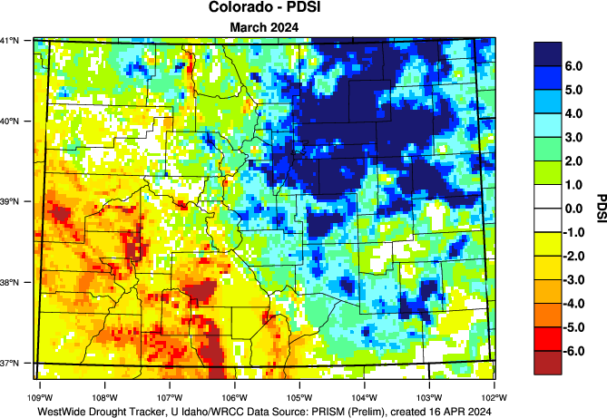
| Westwide Drought Tracker (Western Region Climate Center) |
Vegetation Drought Response (Natl Drought Mitigation Center) |
Quick Drought Response Index (Natl Drought Mitigation Center) |
 |
 |
 |
| SOIL MOISTURE |
|---|
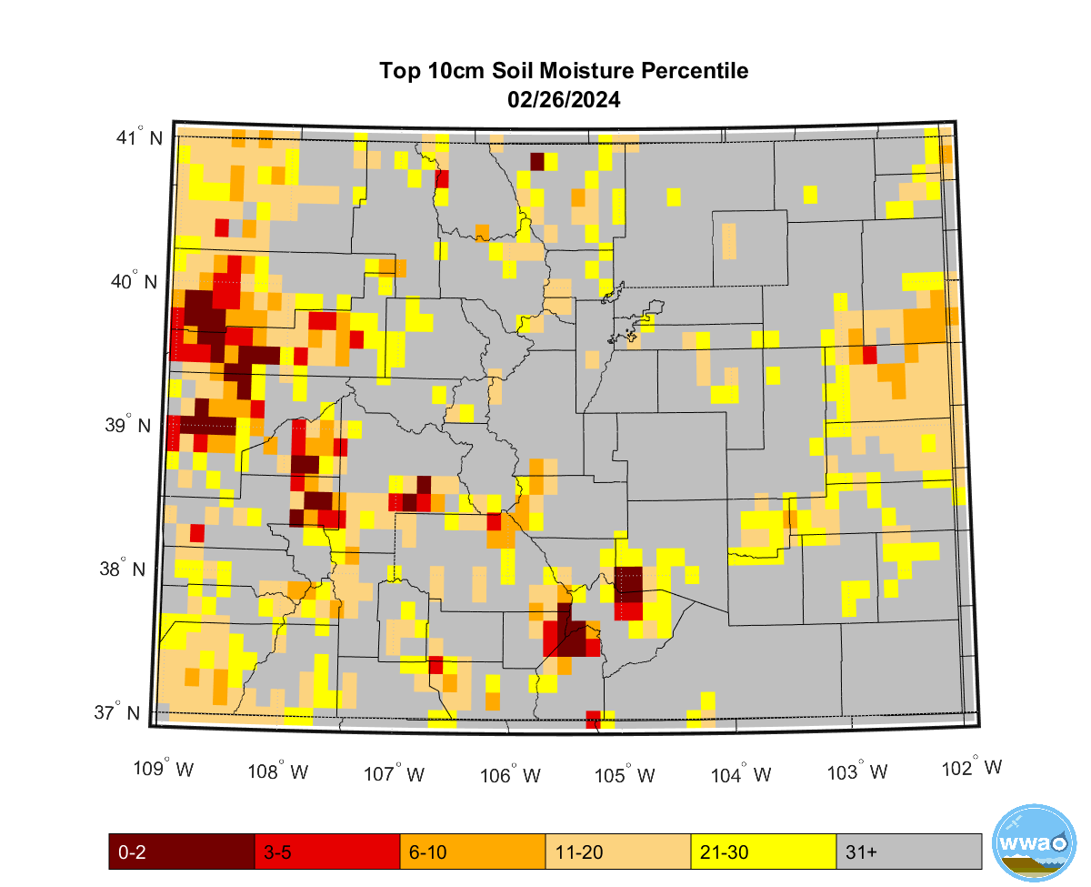
| 10 cm soils in Colorado (Colorado Climate Center) |
top meter soils in Colorado (Colorado Climate Center) |
U.S. Soils, Crops & Drought (NWS Climate Prediction Center) |
 |
 |
Soil Moisture Percentiles or Topsoil Moisture Monitoring or Soil Moisture Anomaly Percentile or Soil Moisture Percentile or Crop Moisture Index or Integrated Drought Indices or Palmer Drought Index Percentiles or Standardized Runoff Index |
| U.S. Drought Monitor Classification Change - Colorado |
|---|
| 3 month | 6 month | 12 month |
 |
 |
 |
| Drought Data Links |
|---|
|
| % of Median Basins & SNOTEL Sites |
% of Median River Basin only |
% of Median SNOTEL sites only |
| Colorado Basins (static map) or CO Basins (interactive) or CO Subbasins (interactive) or |
Colorado (static map) or Colorado Basins (interactive) Colorado Subbasins (interactive) Westwide Basins (static map) or Westwide Basins (interactive) |
Colorado (static map) or Westwide (static map) or CO (interactive) or West of Divide (CBRFC) |
|
| NRCS Basin Recent Years (static) Graphs (below or click here) |
| Arkansas River Basin Last 4 Years |
Rio Grande River Basin Last 4 Years |
 |
 |
| Statewide - Last 4 Years Arkansas Basin - Last 4 Years |
Rio Grande Basin - Last 4 Years |
| NRCS Basin Extreme Years (static) Graphs (below or click here) |
| Arkansas River Basin High/Low Years |
Rio Grande River Basin High/Low Years |
|
|
| Statewide - High/Low Years Arkansas Basin - High/Low Years |
Rio Grande - High/Low Years |
| NRCS Basin and Subbasin (interactive) Graphs (below or click here) |
| Statewide and Basins in South Central and Southeast Colorado. SNOTEL sites | Subbasins in the Arkansas River Basin |
Subbasins in Rio Grande Basin |
| Arkansas River Basin Upper Arkansas River Basin Upper Rio Grande Basin State of Colorado Individual SNOTEL sites |
Upper Arkansas Headwaters Cucharas & Huerfano Purgatorie |
Alamosa Creek Conejoes & Rio San Antonio Culebra & Trinchera Creek |
|
| NWS Snowfall Analysis & Reports | Colorado CoCoRaHS Reports | NWS Monthly Snowfall |
| Snowfall Reports Map (interactive) (from 1 to 72 hr slider) or 7am Contour Map (interactive) (24, 48 or 72 hr snowfall) |
Google Snowfall Map (interactive) (change to Snowfall top left corner) or New Snow H20 content (interactive) or Snowfall Map (click a county) |
NC/NE Colorado Maps |
|
| NOHRSC Colorado Map | Colorado CoCoRaHS Reports | NRCS Colorado Snow Depths |
| Modeled Snow Depths Modeled Snow Depth Change Modeled Snow Depth SWE |
Google Snow Depth Map (change to Snow Depth top left) or New Snow Depth (interactive) or Snow Depth Maps (click county) |
Snow Depth Map (static) or Snow Depth Map (interactive) |
|
| Central Rockies including Western Colorado (below or click here) |
Snow Depth |
Snow Depth SWE Change |
Snow Melt |
| Western Plains including Eastern Colorado (below or click here) |
Snow Depth |
Snow Depth SWE Change |
Snow Melt |
|
| Hourly Graphs | Colorado Maps | U.S. Maps (travel) |
| Gridpoint Forecasts type in lat lon (out 2 days) |
Graphical Forecasts (interactive) (to 7 days) |
Loop of Expected Weather (0.5 to 2.5 days) Daily Forecast Weather (3 days) or Graphical Forecasts (interactive) (to 7 days) |
|
| Percent of Normal Precipitation in Colorado |
| Last 7 days | Last 30 days | Last 90 days | Oct 1st-water year |
 |
 |
 |
 |
| Average Precipitation Departure from Normal in Colorado |
| Last 7 days | Last 30 days | Last 90 days | Oct 1st-water year |
 |
 |
 |
 |
|
| 6 - 10 Day Outlook | 8 - 14 Day Outlook | Week 3-4 Outlook |
 |
 |
 |
| One Month Outlook | Three Month Outlook | following 3 Month Outlook |
 |
 |
 |
|
| Average Temperature Departure from Normal in Colorado |
| Last 7 days | Last 30 days | Last 90 days | Since Oct 1st-water year |
 |
 |
 |
 |
|
| 6 - 10 Day Outlook | 8 - 14 Day Outlook | Week 3-4 Outlook |
 |
 |
 |
| One Month Outlook | Three Month Outlook | following 3 Month Outlook |
 |
 |
 |
|
| % of Average Colorado Maps | % of Average Westwide Map | Average Departure Basin Graphs |
| Individual Reservoirs (interactive) or Colorado Basins (static) |
Individual Reservoirs (interactive) | Arkansas River Basin (static) or Rio Grande Basin (static) or other Colorado basins (static) or all Colorado basins (static) |
|
|
| NWS Map | NRCS Map |
| Western Water Supply Forecasts | Colorado Streamflow Forecasts |

