
Dangerous heat will expand from the Gulf Coast into the Southern Plains and Desert Southwest through week's end. Additional extreme heat impacting the Pacific Northwest will shift to the northern Plains by the weekend. Tropical Storm Bertha is expected to continue to impact portions of the northwestern Gulf Coast from south central Louisiana to the upper Texas coast today. Read More >
January of 2020 was a generally warm and dry month across the region, save for a few passing weather systems within a mainly west to northwest flow pattern, bringing spotty precipitation to the higher terrain along the Continental Divide. February started out where January left off, warm and dry across south central and southeast Colorado, as Colorado Springs (73F) and Pueblo (79F) both setting record high temperatures on the 2nd day of the month. This warmth was short lived however, especially across southeastern Colorado, as multiple weather systems moved across the region bringing much colder temperatures and abundant precipitation (snow) to the area through most of the rest of the month.
March of 2020 started out like a "lion" as a passing weather system brought rain and snow to portions of south central and southeast Colorado through the first two days of the month. A few more weather systems moved across the Rockies through the rest of the month, bringing scattered precipitation which favored western and northern portions of the state. March, however, ended like a "lamb" with warm and dry conditions recorded across all of south central and southeast Colorado. April brought periods of warm and dry conditions, as well as periods of cold and wet conditions to northern and eastern portions of Colorado through the first half of the month, while warm and mainly dry conditions prevailed across southwestern portions of the state. Warm and relatively dry conditions prevailed across the area through the rest of the month, with record breaking heat experienced over portions of south central and southeast Colorado through the last week of April. May was a roller coaster type of month across south central and southeast Colorado, with periods of warm and dry conditions followed by periods of cool and wet conditions, as a few weather systems moved across the state.
June of 2020 continued the roller coaster type of weather pattern as the previous month of May across south central and southeast Colorado, with periods of warm and dry conditions followed by periods of cool and wet conditions, as a few weather systems moved across the state. On June 9th, measurable snowfall was recorded across portions of south central and southeast Colorado, especially across Northern El Paso County and the Palmer Divide. June also brought a few days of severe weather across the region, and produced localized areas of heavy rainfall. July continued the roller coaster type of weather pattern through the first half of the month, with hot and dry conditions followed by cooler and wetter conditions, especially across the southeast plains, where a few frontal passages brought bouts of severe weather to eastern Colorado. The latter portion of July saw an increase in monsoonal moisture across the state, with cooler and wetter conditions experienced into the end of the month. August of 2020 saw its share of severe weather across south central and southeast Colorado, most notably on August 5th, when destructive hail of up to 2 inches in diameter pounded southwestern portions of Colorado Springs. However, most of August of 2020 will be remembered for being generally hot and dry, with several major wildland fire starts across northern and western portions of Colorado, including the Pine Gulch fire in western Colorado, which had grown (at the time) to be largest wildfire on record in Colorado.
September of 2020 was a month of extremes across south central and southeast Colorado. The first week of the month was extremely warm, with Alamosa, Colorado Springs and Pueblo all setting new monthly record high temperatures, with a possible new Colorado September record high temperature of 108 degrees set in La Junta on September 6th. This was followed by record cold temperatures and record snowfall, as an unseasonably cold and strong storm system moved across the state September 8th through September 10th. Generally warm and dry conditions were experienced across the state through the rest of September, with a few minor fronts bringing a few days of slightly cooler temperatures to the region. October of 2020 was another month of extremes across south central and southeast Colorado. The first half of the month saw extremely warm and mainly dry conditions statewide, with Colorado Springs (87F) and Pueblo (94F) both tying their respective record high monthly temperatures. This was followed by record cold temperatures and record snowfall, as another unseasonably cold and strong storm system moved across the state October 25th through October 27th. This unseasonably cold system allowed Pueblo to also set its coldest October day on record, when the low temperature dropped to -8 degrees on October 26th. The month of October also saw multiple wildfire starts across the state, including the Cameron Peak Fire, which would become the largest wildfire on record in Colorado at over 200,000, as well as the Troublesome Fire, which would become the second largest wildfire on record across the state, growing over 100,000 acres in one day (from October 21st to 22nd).
November of 2020 started out very warm and dry across south central and southeast Colorado. The rest of the month saw ebbs and flows of temperatures, as a few passing weather systems brought some beneficial moisture to mainly the central and southwest mountains, along with some briefly cooler temperatures to the region, before warmer and drier conditions returned. December also saw ebbs and flows of temperatures, as a several passing weather systems brought beneficial moisture and snowfall, especially to portions of the southeast mountains and plains, along with some briefly cooler temperatures to the region, before warmer and drier conditions returned.
The following graphics depict preliminary departures from normal for both temperature and precipitation for 2020 across Colorado.
.png) |
.png) |
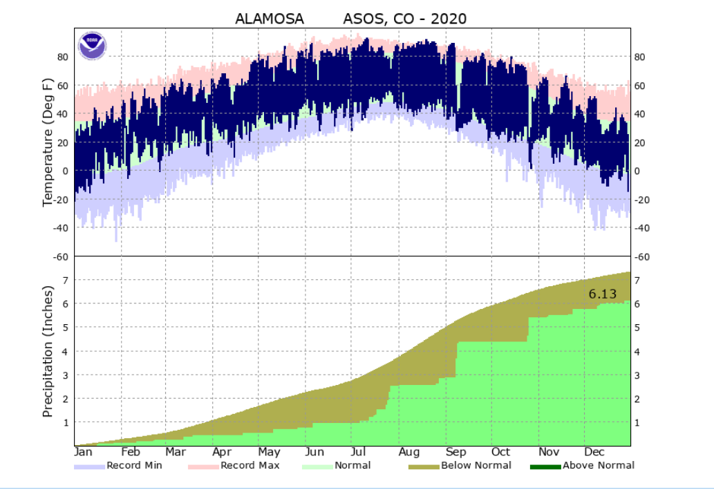
The 2020 average temperature in Alamosa was 44.0 degrees. This is 2.4 degrees above normal and makes 2020 tied with 2018 as the 5th warmest year on record in Alamosa. Alamosa recorded 6.13 inches of precipitation through 2020, which is 1.18 inches below normal. Alamosa tallied 35.2 inches of snow in 2020, which is 7.6 inches above normal. A more detailed 2020 climate summary for Alamosa can be found at:
2020 Alamosa Annual Climate Summary
 |
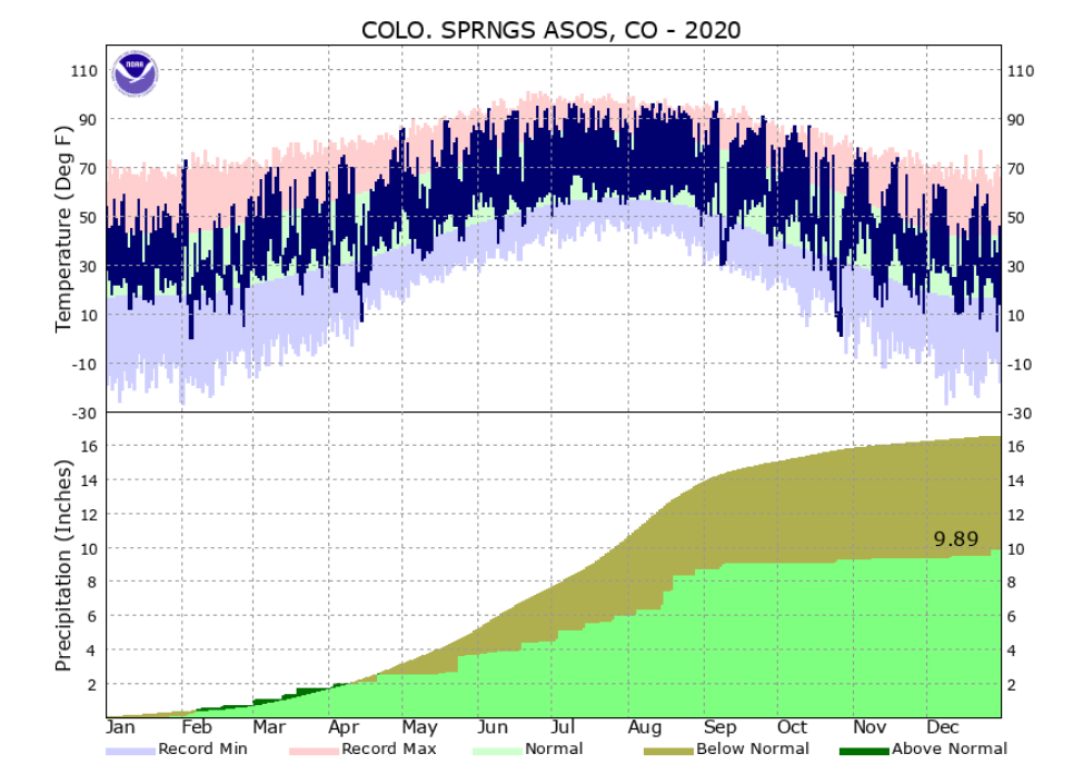
The 2020 average temperature in Colorado Springs was 51.9 degrees. This is 2.9 degrees above normal and makes 2020 the 5th warmest year on record in Colorado Springs. Colorado Springs recorded 9.89 inches of precipitation through out 2020. This is 6.65 inches below normal and makes 2020 the 14th driest year on record in Colorado Springs. Colorado Springs tallied 42.0 inches of snow through out 2020, which 4.3 inches above normal. A more detailed 2020 climate summary for Colorado Springs can be found at:
2020 Colorado Springs Annual Climate Summary
 |
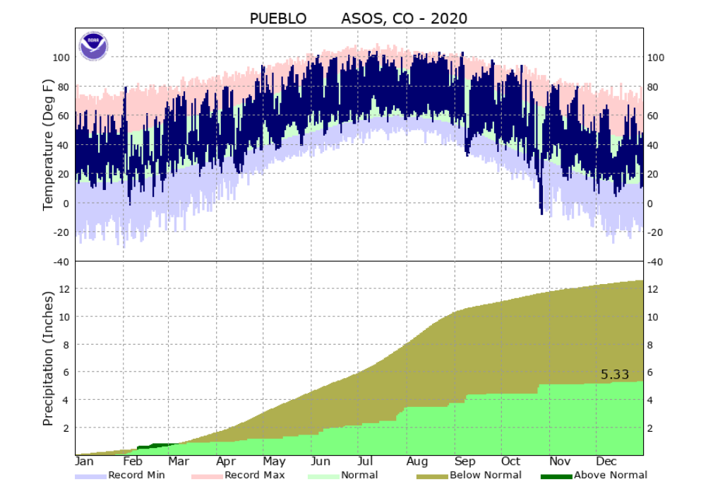
The 2020 average temperature in Pueblo was 54.6 degrees. This is 2.6 degrees above normal and makes 2020 tied with 2017 as the 9th warmest year on record in Pueblo. Pueblo recorded 5.33 inches of precipitation through out 2020. This is 7.37 inches below normal and makes 2020 the 3rd driest year on record in Pueblo, just behind the 3.94 inches and 5.00 inches recorded in 2002 and 2012 respectively. Pueblo tallied 28.9 inches of snow through out 2020, which is 2.9 inches below normal. A more detailed 2020 climate summary for Pueblo can be found at:
2020 Pueblo Annual Climate Summary
 |

