
A heat wave over the Southwest will intensify late week, peaking and expanding into the Intermountain West and northern High Plains this weekend. Severe thunderstorms and heavy rain are expected over portions of the Plains and Mississippi Valley tonight, which will shift to parts of the Upper Midwest and mid-Mississippi Valley Friday. Monsoonal showers and flooding persist in the Desert Southwest. Read More >
2025 started out cold, especially across eastern Colorado, which saw several cold air outbreaks throughout the month, culminating in the late January 17th through January 21st timeframe, when a true Arctic airmass moved across Colorado. In true Colorado fashion, the end of the Arctic outbreak saw temperatures in both Colorado Springs (61F) and Pueblo (68F) warm over 60 degrees in less than 24 hours! February saw up and down temperatures and precipitation, especially across eastern Colorado, where a few polar intrusions brought periods of very cold temperatures and precipitation to southeast Colorado.
March was a generally warm and windy month across south central and southeast Colorado. This brought increased fire danger to the snow free areas, as well as a few days with reduced visibility due to blowing dust across southern Colorado. A few passing weather systems did bring cooler temperatures and some precipitation, most notably a system on March 18th and 19th, which brought a period of heavy wind driven snow to portions of the southeast Plains. April was a roller coaster type of month, with cool and wet periods at the beginning and middle of the month, along with warm, dry and windy periods in between. This also brought increased fire danger to the snow free areas for much of April. May was another roller coaster type of month, with slow moving weather systems bringing cool and wet periods at the beginning, middle and end of the month, along with a few warm, dry and windy periods in between. However, the above normal precipitation and associated green up helped to taper fire danger across the area.
June was a fairly active month, with several passing weather systems bringing cool and wet periods through out the month, including periods of severe weather across eastern Colorado. June also saw periods of upper level ridging allowing for warm and dry periods through out the month as well. July saw a meandering ridge of high pressure across the Rockies, which brought periods of warm and dry conditions, as well as cooler and wetter periods, with periods of severe weather and heavy monsoon rainfall across south central and southeast Colorado. August also saw a meandering ridge of high pressure across the Rockies, which brought periods of very warm and dry conditions, as well as cooler and wetter periods. There were also periods of severe weather and heavy monsoon rainfall across portions of south central and southeast Colorado, especially in the last 10 days of the month.
September continued the previous few months weather pattern of a meandering ridge of high pressure across the Rockies, which brought periods of warm and dry conditions, as well as cooler and wetter periods. There were also periods of severe weather and heavy rainfall across portions of south central and southeast Colorado. October also saw a meandering ridge of high pressure across the Rockies, which brought mainly warm and dry conditions to the region as a whole. However, periods of heavy rainfall and flooding were experienced across portions of southwestern Colorado, and into western portions of south central Colorado, in the October 9th through 14th timeframe, when remnants of Hurricane Priscilla moved across western portions of the state. Widespread rainfall totals of 2 to 6 inches were recorded over that 5 day timeframe, with local amounts of almost 8 inches recorded at the Wolf Creek SNOTEL station. November was very warm and mainly dry across south central and southeast Colorado. However, a few passing weather systems towards the end of the month brought some areas of rain, with Colorado Springs setting a new daily rainfall record of 1.10 inches on November 23rd. December was very warm and dry across south central and southeast Colorado, save for one passing storm system at the beginning of the month, which did bring some rain and snow to the area.
The following graphics depict preliminary departures from normal for both temperature and precipitation for 2025 across Colorado.
 |
 |
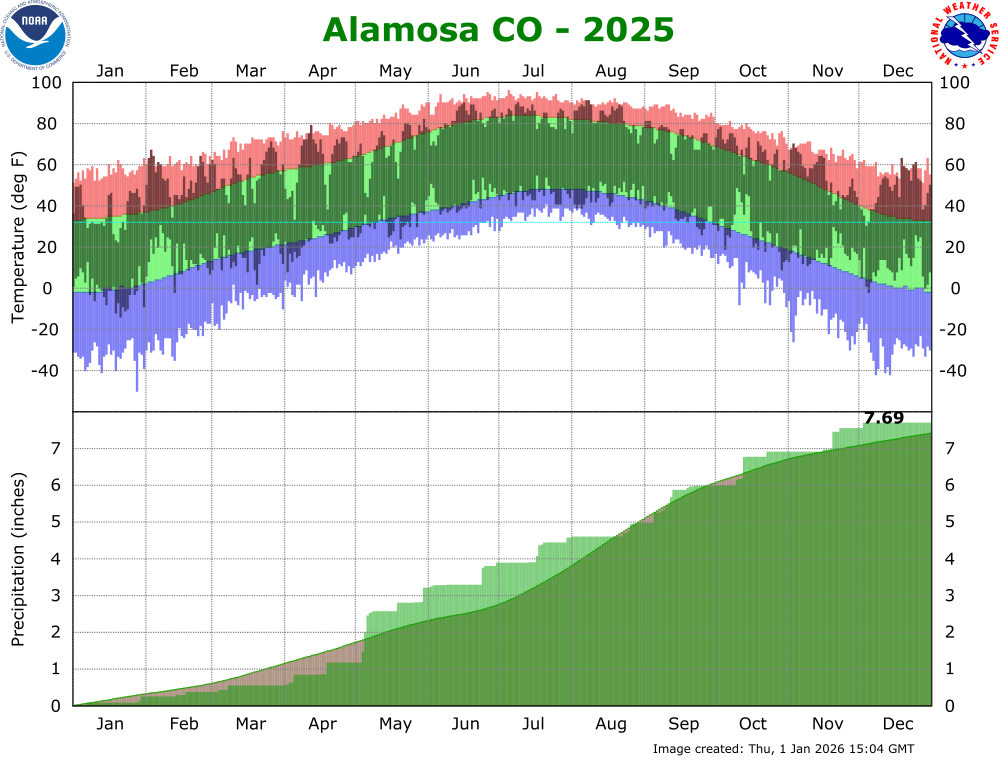
The 2025 average temperature in Alamosa was 45.1 degrees. This is 2.8 degrees above normal and makes 2025 the warmest year on record in Alamosa, surpassing the annual average temperature of 44.7F in 2017 and 2024. Alamosa recorded 7.69 inches of precipitation in 2025. This is 0.28 inches above normal and makes 2025 the 35th wettest year on record in Alamosa. Alamosa tallied 19.8 inches of snow in 2025. This is 8.1 inches below normal and makes 2025 the 19th least snowiest year on record. A more detailed 2025 climate summary for Alamosa can be found at:
2025 Alamosa Annual Climate Summary (POR 1932-2025)
 |
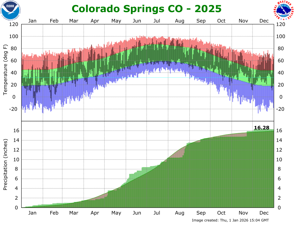
The 2025 average temperature in Colorado Springs was 51.5 degrees. This is 1.1 degrees above normal and makes 2025 the 9th warmest year on record in Colorado Springs, well behind the average yearly temperature of 52.9F in 2012. Colorado Springs recorded 16.25 inches of precipitation in 2025. This is 0.37 inches above normal and makes 2025 the 46th wettest year on record in Colorado Springs. Colorado Springs tallied 27.5 inches of snow in 2025. This is 5.0 inches below normal and makes 2025 the 34th least snowiest year on record. A more detailed 2025 climate summary for Colorado Springs can be found at:
2025 Colorado Springs Annual Climate Summary (POR 1894-2025)
 |
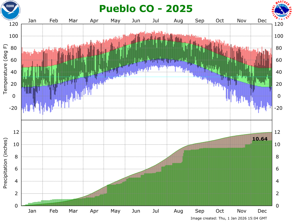
The 2025 average temperature in Pueblo was 54.3 degrees. This is 1.1 degrees above normal and makes 2025 the 14th warmest year on record. Pueblo recorded 10.64 inches of precipitation in 2025. This is 1.38 inches below normal and makes 2025 the 52nd driest year on record in Pueblo. Pueblo tallied 26.4 inches of snow in 2025. This is 1.9 inches below normal and makes 2024 the 61st least snowiest year on record. A more detailed 2025 climate summary for Pueblo can be found at:
2025 Pueblo Annual Climate Summary (POR 1888-2025)
 |

