Pueblo, CO
Weather Forecast Office
The extreme rainfall of September 11-15 across eastern Colorado was focused on the northern Front Range, where catastrophic damage and several fatalities occurred.
The areal coverage of the heavy rainfall and damage here in southern Colorado was mostly confined to the Pikes Peak Region. Rainfall amounts were heaviest from northern Fort Carson to the southwest side of Colorado Springs, where totals in excess of one foot were recorded. One rain gage on the north side of Fort Carson recorded over 12 inches of rain in a 24-hour period. If this rain gage proves to be reliable by the State Climatologist, this would be a new record 24-hour rainfall for Colorado. More on this in the coming weeks.
There was considerable damage on the southwest side of Colorado Springs from the runoff in North and South Cheyenne watersheds and the Rock Creek watershed flowin onto Fort Carson. Numerous trails and roads were flooded and damaged. Here is a photo of Gold Camp Road, on US Forest Service land in North Cheyenne Canyon. Repairs will likely take weeks or months...
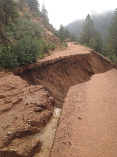
photo by Colorado Springs Parks
South and North Cheyenne Creeks meet to form Cheyenne Creek which flows into southwest Colorado Springs.
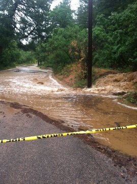
photo of North Cheyenne Creek flooding over the canyon road by Lindsey Watts, KRDO-TV
Major flooding occurred on Cheyenne Creek in southwest Colorado Springs, damaging scores of houses and destroying one.
Tragically, two people lost their lives during the episode in Colorado Springs. One man drowned in Fountain Creek early Thursday morning, and another man drowned in Sand Creek on Sunday.
This website was recently put together by the Colorado Climater Center at CSU-Ft. Collins. While much of it focuses on northern Colorado flooding, there is some information on the rest of Colorado, and the site will be updated when time permits.
ACTIVE ALERTS
Warnings by State - click ATOM button
Excessive Rainfall Forecasts
River Flooding
Convective Outlooks
Hurricanes
Fire Weather Outlooks
UV Alerts
Space Weather
Winter Winter Forecasts
Enhanced Data Display(EDD)
PAST WEATHER
Climate Monitoring
Astronomical Data
Certified Weather Data
CURRENT CONDITIONS
Radar
River Levels
Observed Precipitation
Surface Weather
Upper Air
Marine and Buoy Reports
Climate Monitoring
Snow Cover
Satellite
Space Weather
Enhanced Data Display(EDD)
FORECAST
Severe Weather
Drought
Fire Weather
Front/Precipitation Maps
Graphical Foreast Maps
Rivers
Marine
Offshore and High Seas
Hurricanes
Aviation Weather
Climate Outlook
Enhanced Data Display(EDD)
WEATHER SAFETY
Owlie Skywarn - for kids
NOAA Weather Radio
StormReady
Natural Weather Hazard Statistics
Red Cross
Federal Emergency Management Agency(FEMA)
National Weather Service SafetyBrochures
US Dept of Commerce
National Oceanic and Atmospheric Administration
National Weather Service
Pueblo, CO
3 Eaton Way
Pueblo, CO 81001-4856
(719) 948-9429
Comments? Questions? Please Contact Us.

