Overview
|
A winter storm, designated as a Miller B type storm, brought mainly snow, with some sleet and freezing rain to the area. The mixture of the sleet and freezing rain cut into the overall totals of snow, but still many saw over 4 inches by the time the storm wrapped up Monday Jan 17th, with the highest totals across the mountains of WV, southwest VA and northwest NC. The snow began prior to dawn in the North Carolina mountains, then overspread most of the region by midday. Warmer air starting pushing in from the southeast 3-4 thousand feet above ground level, causing a mix to sleet, and freezing rain. This warmer air made it to the I-81 corridor/New River Valley and far SW VA, before the colder air pushed back in as the low moved northeast.
Behind the storm winds gusted over 55 to 60 mph in the mountains. This video was courtesy of Steve Marks in Vilas, NC. |
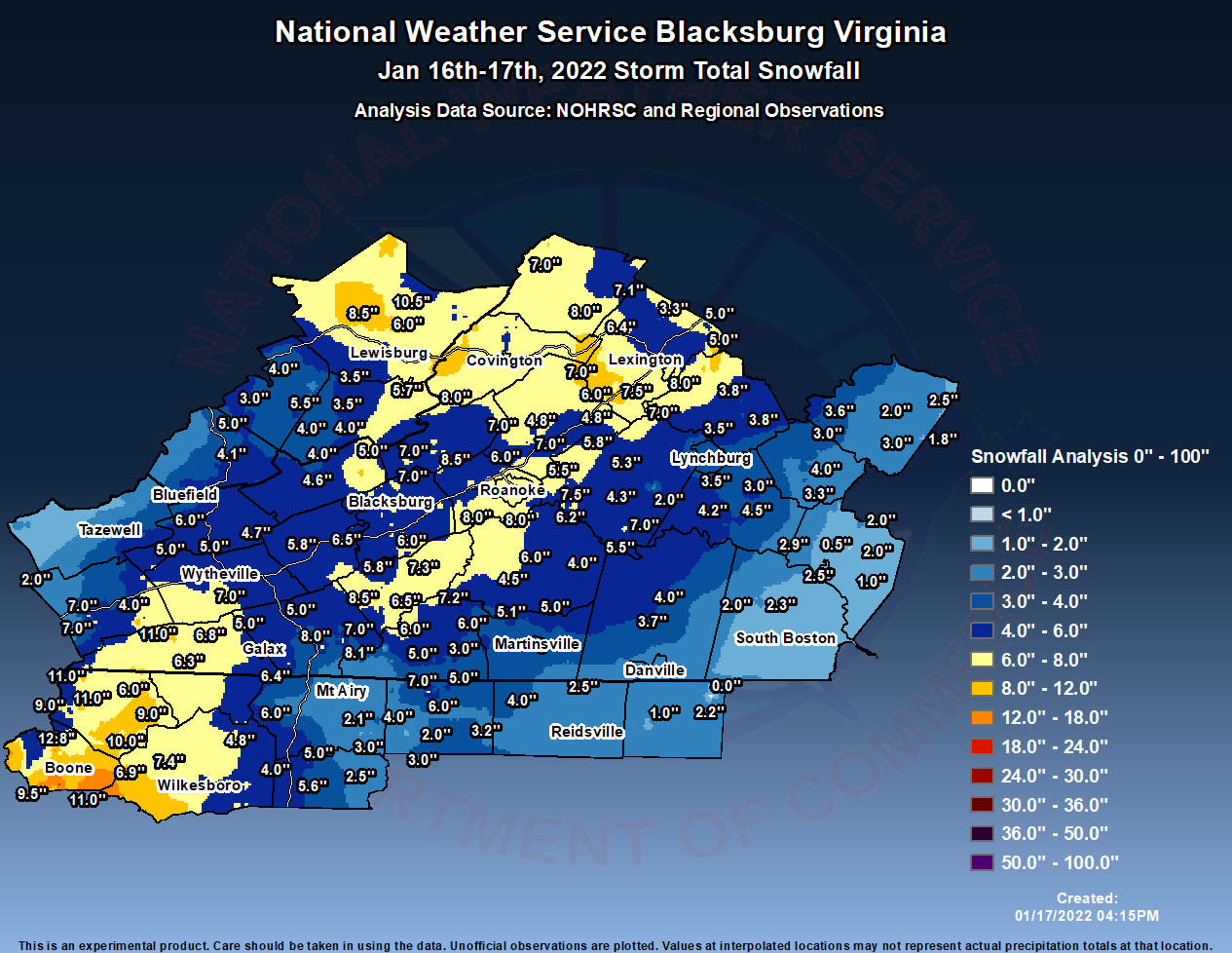 This is the snowfall analysis from the main storm of Jan 16th-17th (not counting the upslope that occurred on the 17th). |
Snow/Ice
Here are the reports of snowfall, sleet and ice from the storm, not counting the additional snow showers accumulating in the mountains Monday Jan 17th.
This should be the finall summary of snowfall from the main storm of
Jan 16th, as we included our cooperative observers and COCORAHS
observers.

Location                     Amount    Time/Date       Provider

...North Carolina...

...Ashe County...
2 E Ashland                  11.0 in   0612 PM 01/16   Public
1 E Flatwood                 11.0 in   0900 AM 01/17   Public
2 NE Deep Gap                10.0 in   0700 AM 01/17   COCORAHS
1.9 NW Wagoner               9.0 in    0620 AM 01/17   COOP
2 W Ashland                  9.0 in    0900 AM 01/17   Public
2 SW Ashland                 7.0 in    0815 AM 01/17   COCORAHS
3 N Shatley Springs          6.5 in    0535 PM 01/16   Public
1 SE Lansing                 6.0 in    0545 PM 01/16   Trained Spotter

...Caswell County...
1.1 NE Topnot                2.2 in    0700 AM 01/17   COOP
4 ESE Quick                  1.0 in    0930 PM 01/16   Public


...Rockingham County...
1 NW Mayodan                 4.0 in    0549 PM 01/16   Public
Eden                         2.5 in    0630 AM 01/17   COOP
3 W Reidsville               2.0 in    0500 PM 01/16   Public

...Stokes County...
2 NW Lawsonville             7.0 in    0830 PM 01/16   Public
Lawsonville                  6.0 in    0800 AM 01/17   COCORAHS
Lawsonville 2.1 NE           5.0 in    0800 AM 01/17   COCORAHS
Walnut Cove 1.5 ENE          3.2 in    0800 AM 01/17   COCORAHS
King                         3.0 in    0700 AM 01/17   COOP
King 4.2 NNE                 2.0 in    0700 AM 01/17   COCORAHS
King 4.2 N                   1.4 in    0700 AM 01/17   COCORAHS

...Surry County...
1 N Thurmond                 6.0 in    1046 PM 01/16   Public
Pilot Mountain 0.3 W         4.0 in    0700 AM 01/17   COCORAHS
4 N Bottom                   3.3 in    0745 PM 01/16   Public
4 NNW Pilot Mountain         2.1 in    0500 PM 01/16   Trained Spotter

...Watauga County...
Boone                        13.0 in   0500 PM 01/16   Public
3 SE Silverstone             12.8 in   1102 AM 01/17   Public
2 E Boone                    12.0 in   0500 PM 01/16   Public
Blowing Rock                 11.0 in   0400 PM 01/16   Public
1 NNW Beech Mountain         10.5 in   0845 AM 01/17   Public
1 SE Rutherwood              10.0 in   0800 AM 01/17   COCORAHS
Seven Devils                 9.5 in    1000 AM 01/17   COCORAHS
Blowing Rock 2.2 NE          9.4 in    0700 AM 01/17   COCORAHS
3 W Blowing Rock             8.5 in    1030 PM 01/16   Public
Foscoe                       8.0 in    0501 PM 01/16   Public
1 NNW Todd                   7.8 in    0549 PM 01/16   Public
Valle Crucis                 7.3 in    0400 PM 01/16   Broadcast Media
1 E Seven Devils             6.6 in    0700 AM 01/17   COCORAHS
Valle Crucis                 6.5 in    0700 AM 01/17   COCORAHS
Reese                        6.0 in    0851 AM 01/17   COCORAHS

...Wilkes County...
2 NE Maple Springs           7.4 in    0821 PM 01/16   Public
2 NNE Maple Springs          6.9 in    0448 PM 01/16   Cocorahs
North Wilkesboro 5.5 SE      4.9 in    0700 AM 01/17   COCORAHS
2 NNW Benham                 4.8 in    0800 PM 01/16   Public
0.6 SW North Wilkesboro      4.2 in    0830 AM 01/17   COOP

...Yadkin County...
Hamptonville 1.5 NNW         5.6 in    0700 AM 01/17   COCORAHS
2 WSW Boonville              5.0 in    0956 AM 01/17   Trained Spotter
2 SSE Swancreek              4.0 in    0600 PM 01/16
2 NW East Bend               3.0 in    0500 PM 01/16   Public
3.1 E Shacktown              2.5 in    0700 AM 01/17   COOP

...Virginia...

...Alleghany County...
Covington 4.1 E              8.0 in    0700 AM 01/17   COCORAHS
3 S Hollins                  6.0 in    0429 PM 01/16   Trained Spotter

...Amherst County...
3 NW Amherst                 3.8 in    0708 PM 01/16   Public
Amherst 1.7 SW               3.8 in    0800 AM 01/17   COCORAHS
2 SW Amherst                 3.8 in    0900 AM 01/17   Trained Spotter

...Appomattox County...
Appomattox                   4.0 in    0920 PM 01/16   Public
3 ESE Oakville               3.8 in    1048 PM 01/16   Trained Spotter
3 WNW Evergreen              3.3 in    1000 PM 01/16   Public
2 WSW Tower Hill             3.0 in    0915 AM 01/17   Public

...Bath County...
Millboro 0.3 NW              8.0 in    0700 AM 01/17   COCORAHS
Goshen 3.3 WNW               7.1 in    0800 AM 01/17   COCORAHS
Mountain Grove               7.0 in    0300 AM 01/17   CO-OP Observer

...Bedford County...
Goodview                     7.5 in    0920 AM 01/17   Public
3.6 SW Huddleston            7.0 in    0700 AM 01/17   COOP
3 ENE Vinton                 6.5 in    1015 PM 01/16   Public
Stewartsville                6.2 in    0910 PM 01/16   Public
2 W Goodview                 6.2 in    0920 PM 01/16   Public
Goodview 3.2 SSE             5.6 in    0800 AM 01/17   COCORAHS
Vinton 8.6 ENE               5.5 in    0815 AM 01/17   COCORAHS
Bedford                      5.3 in    0420 PM 01/16   Public
Moneta 3.6 SW                4.5 in    0800 AM 01/17   COCORAHS
4 SSE Thaxton                4.3 in    0430 PM 01/16   Trained Spotter
2 WSW Boonsboro              4.0 in    0411 PM 01/16
Bedford 3.2 W                4.0 in    0830 AM 01/17   COCORAHS
Lynchburg 5.1 NNW            3.5 in    0700 AM 01/17   COCORAHS
3 ENE Boonsboro              3.5 in    0859 AM 01/17   Public
Boonsboro                    2.8 in    0824 AM 01/17   Public
6 SSW Goode                  2.0 in    0559 PM 01/16   Public

...Bland County...
Bastian                      6.0 in    0125 PM 01/17   Public
Bland                        5.0 in    0900 PM 01/16   Trained Spotter
3 SW Long Spur               4.7 in    0745 AM 01/17   Trained Spotter

...Botetourt County...
5 NW Daleville               7.1 in    1040 AM 01/17   Cocorahs
2 SSW Fincastle              7.0 in    0811 PM 01/16   Public
Fincastle 5.4 WSW            7.0 in    0845 AM 01/17   COCORAHS
1 ESE Cloverdale             6.8 in    0730 PM 01/16   Public
2 E Lithia                   5.8 in    0545 PM 01/16   Trained Spotter
Fincastle                    4.8 in    0500 PM 01/16   Broadcast Media
1 WSW Buchanan               4.8 in    0600 PM 01/16   Trained Spotter

...Buckingham County...
3 NNE Tower Hill             3.6 in    0730 PM 01/16   Public
3.3 S Buckingham             3.0 in    0700 AM 01/17   COOP
1 NNW Gold Hill              2.5 in    1016 PM 01/16   Public
2 W Dillwyn                  2.0 in    0900 AM 01/17   CO-OP Observer
7 SE Dillwyn                 1.8 in    0404 PM 01/16   Public

...Campbell County...
Gladys 0.6 S                 4.5 in    0700 AM 01/17   COCORAHS
3 SSE Evington               4.2 in    0600 PM 01/16   Public
3.6 NW Spring Mills          3.0 in    0700 AM 01/17   COOP
1.5 NE Brookneal             2.9 in    0700 AM 01/17   COOP

...Carroll County...
3 ESE Gladesboro             8.1 in    0258 PM 01/17   Trained Spotter
Fancy Gap                    8.0 in    1256 PM 01/17   Trained Spotter
3 ESE Gladesboro             7.0 in    0938 PM 01/16   Public
3 SSE Pipers Gap             6.4 in    0500 PM 01/16   Public
Galax 6.1 N                  5.0 in    0700 AM 01/17   COCORAHS
Hillsville 3.7 W             5.0 in    0700 AM 01/17   COCORAHS
1 ENE Galax Hillsville Airpo 5.0 in    0700 AM 01/17   Cocorahs
2 SSE Byllesby               5.0 in    0809 AM 01/17   Trained Spotter

...Charlotte County...
3 S Aspen                    2.5 in    0255 PM 01/17   Trained Spotter
3 WSW Abilene                2.0 in    0600 PM 01/16   Trained Spotter
Drakes Branch                2.0 in    0230 PM 01/17   Trained Spotter
2 SW Drakes Branch           1.0 in    0830 AM 01/17   Public
1 WNW Charlotte Court House  0.5 in    0230 PM 01/17   Trained Spotter

...City of Buena Vista County...
Buena Vista City             8.2 in    0700 AM 01/17   COOP
1 E Buena Vista City         8.0 in    0504 PM 01/16   Public

...City of Galax County...
0.9 S Galax City             6.5 in    0700 AM 01/17   COOP

...City of Lexington County...
Lexington 0.8 W              6.5 in    0700 AM 01/17   COCORAHS

...City of Lynchburg County...
Lynchburg 2.5 WSW            4.0 in    0700 AM 01/17   COCORAHS
3 ENE Forest                 4.0 in    0848 AM 01/17   Public
2 N Lynchburg Airport        3.5 in    0536 PM 01/16   Public
1 WSW Lynchburg City         3.5 in    0833 PM 01/16   Broadcast Media

...City of Martinsville County...
1.5 N Martinsville City      3.5 in    0700 AM 01/17   COOP

...City of Radford County...
Radford 0.9 WNW              6.5 in    0510 AM 01/17   COCORAHS
1 SSW Radford                5.3 in    1100 PM 01/16   Trained Spotter

...City of Roanoke County...
2 S Roanoke                  7.4 in    1045 PM 01/16   Public
2 S Roanoke Airport          7.1 in    0912 PM 01/16   Broadcast Media
2 SE Hollins                 6.2 in    1113 PM 01/16   Trained Spotter
1 S Roanoke Airport          6.0 in    0524 PM 01/16   Broadcast Media

...City of Salem County...
Salem City                   7.5 in    0700 PM 01/16   Public
2 NNE Salem City             7.5 in    1020 PM 01/16   Trained Spotter
Salem 1.6 WSW                6.1 in    0700 AM 01/17   COCORAHS
1 NW Salem City              5.5 in    0400 PM 01/16   Public
2 WSW Salem City             5.5 in    0501 PM 01/16   Public
1 SE Salem City              5.0 in    0101 AM 01/17   Public

...Craig County...
Simmonsville                 7.0 in    0808 AM 01/17   CO-OP Observer
2 NW Maggie                  5.0 in    0406 PM 01/16   Public

...Floyd County...
Willis                       8.5 in    0836 PM 01/16   Public
Willis 2.7 SE                6.5 in    0700 AM 01/17   COCORAHS

...Franklin County...
Rocky Mount                  6.0 in    0700 AM 01/17   COOP
5 N Penhook                  5.5 in    0625 PM 01/16   Trained Spotter
Rocky Mount 10.3 NE          5.0 in    0700 AM 01/17   COCORAHS
3 S Rocky Mount              4.5 in    0500 PM 01/16   Public
Union Hall 2.9 E             4.0 in    0700 AM 01/17   COCORAHS

...Giles County...
Bane                         4.6 in    0700 AM 01/17   COOP

...Grayson County...
4 SSW Spring Valley          6.8 in    0922 AM 01/17   Trained Spotter
Independence 1.3 S           6.3 in    0500 AM 01/17   COCORAHS

...Halifax County...
6 W Crystal Hill             2.3 in    0955 PM 01/16   Public
2 ESE Ridgeway               2.0 in    0953 AM 01/17   Public
1.1 E South Boston           1.8 in    0700 AM 01/17   COOP
1 ESE South Boston           1.8 in    0816 AM 01/17   CO-OP Observer

...Henry County...
Bassett 1.1 E                5.1 in    0730 AM 01/17   COCORAHS
Figsboro                     5.0 in    0810 AM 01/17   Broadcast Media

...Montgomery County...
Elliston                     7.5 in    1059 PM 01/16   Trained Spotter
2 S Pilot                    7.3 in    0800 AM 01/17   Public
4 NNE Blacksburg             7.0 in    0256 AM 01/17   NWS Employee
1 NE Merrimac                6.9 in    0700 PM 01/16   Official NWS Obs
2 NE Blacksburg              6.8 in    1000 AM 01/17   NWS Employee
Christiansburg               6.0 in    0700 AM 01/17   COOP
Blacksburg 5.0 W             5.8 in    0800 AM 01/17   COCORAHS
4 NW Pilot                   5.5 in    1030 PM 01/16   NWS Employee
Christiansburg 4.4 WNW       5.5 in    0700 AM 01/17   COCORAHS
Christiansburg 1.1 ESE       5.2 in    0745 AM 01/17   COCORAHS
Blacksburg 1.3 ESE           5.1 in    0900 AM 01/17   COCORAHS
3 NNW Blacksburg             5.0 in    1244 PM 01/17   Trained Spotter
Blacksburg 2.4 ENE           4.4 in    0700 AM 01/17   COCORAHS
2 SSE Pilot                  4.3 in    0415 PM 01/16   Trained Spotter
Blacksburg 1.6 W             4.0 in    0700 AM 01/17   COCORAHS

...Patrick County...
Woolwine 3.7 NNE             7.2 in    0800 AM 01/17   COCORAHS
4 E Buffalo Ridge            6.0 in    0427 PM 01/16   Trained Spotter
Woolwine 0.4 SW              6.0 in    0900 AM 01/17   COCORAHS
1.6 E Stuart                 5.0 in    0700 AM 01/17   COOP
Stuart 4.0 ESE               3.0 in    0700 AM 01/17   COCORAHS
Meadows Of Dan 5 SW          1.5 in    0700 AM 01/17   COOP

...Pittsylvania County...
Pittsville 4.5 NNW           5.0 in    0700 AM 01/17   COCORAHS
Chatham                      4.0 in    0700 AM 01/17   COOP
4 WSW Dry Fork               3.7 in    0451 PM 01/16   Public

...Pulaski County...
2 NW Copper Valley           5.8 in    0707 AM 01/17   Trained Spotter
Dublin 2.0 SSW               5.8 in    0730 AM 01/17   COCORAHS
Graysontown                  5.3 in    0606 PM 01/16   Trained Spotter
Fairlawn 1.8 WNW             4.7 in    0700 AM 01/17   COCORAHS

...Roanoke County...
3 N Bradshaw                 8.5 in    0904 AM 01/17   Public
2 SE Cave Spring             8.0 in    0910 PM 01/16   Public
Cave Spring 2.4 SSW          8.0 in    0700 AM 01/17   COCORAHS
3 ESE Cave Spring            7.5 in    0651 PM 01/16   Trained Spotter
3 ESE Elliston-Lafayette     7.5 in    1000 PM 01/16   Public
Roanoke 5.5 SW               7.5 in    0700 AM 01/17   COCORAHS
Roanoke 7.3 SSW              7.0 in    0700 AM 01/17   COCORAHS
Salem 3.4 WNW                7.0 in    0900 AM 01/17   COCORAHS
1.3 N Hollins                6.0 in    0700 AM 01/17   COOP
1 SE Cave Spring             5.8 in    0400 PM 01/16   Public
3 N Salem City               5.8 in    0400 PM 01/16   Public
Salem 5.1 W                  3.9 in    0700 AM 01/17   COCORAHS

...Rockbridge County...
4 WSW Buena Vista City       7.5 in    0900 PM 01/16   Trained Spotter
Glasgow 1 SE                 7.0 in    0700 AM 01/17   COOP
Lexington 11.5 WSW           7.0 in    0800 AM 01/17   COCORAHS
Lexington 8.6 NW             6.4 in    0700 AM 01/17   COCORAHS
3 NNW Natural Bridge         6.0 in    0835 AM 01/17   Public
1 NW Vesuvius                5.0 in    0716 PM 01/16   Public
Vesuvius                     5.0 in    0855 AM 01/17   Public
3 NNE Rockbridge Baths       3.3 in    0300 AM 01/17   Trained Spotter

...Smyth County...
Sugar Grove                  11.0 in   0740 AM 01/17   Law Enforcement
Thomas Bridge                7.0 in    0740 AM 01/17   Law Enforcement
Adwolf                       7.0 in    0740 AM 01/17   Law Enforcement
2 W Marion                   5.0 in    1215 PM 01/17   Trained Spotter
Marion                       4.0 in    1211 PM 01/17   Public
0.8 SW Allison Gap           2.0 in    0700 AM 01/17   COOP

...Tazewell County...
Bluefield                     5.5 in    1205 PM 01/17   Broadcast Media
1 SE Burkes Garden           5.0 in    0730 PM 01/16   CO-OP Observer
0.9 SE Burkes Garden         5.0 in    0600 AM 01/17   COOP
3 WNW Tazewell               2.7 in    0830 AM 01/17   COCORAHS
1 SSW Bluefield               2.5 in    1030 PM 01/16   Public

...Wythe County...
3 SSW Wytheville             7.0 in    0942 PM 01/16   Public
3 N Coleman Store            5.0 in    0510 PM 01/16   Public
2 WSW Wytheville             5.0 in    0800 AM 01/17   Trained Spotter

...West Virginia...

...Greenbrier County...
3 WSW Renick                 10.5 in   0315 PM 01/17   Public
3 ENE Meadow Bluff            8.5 in   1152 AM 01/17   Broadcast Media
0.9 SW White Sulphur Springs 7.0 in    0700 AM 01/17   COOP
3 WSW Renick                 6.0 in    0400 PM 01/16   Public
2 ESE Organ Cave             5.7 in    0510 PM 01/16   Trained Spotter
Lewisburg 1.7 W              5.0 in    0800 AM 01/17   COCORAHS
1 SE Lewisburg               5.0 in    0800 AM 01/17   Public
2 N Lewisburg                4.0 in    0400 PM 01/16   Public
White Sulphur Springs        4.0 in    0457 PM 01/16   Public

...Mercer County...
1 SSE Bluefield               6.1 in    0900 AM 01/17   Trained Spotter
2 ESE Bluefield               5.0 in    1145 AM 01/17   Broadcast Media
Princeton 0.3 NNW            4.1 in    0700 AM 01/17   COCORAHS
Bluefield                     3.1 in    1000 PM 01/16   Public
1 SW Bluefield                3.0 in    0947 AM 01/17   CO-OP Observer
1 SE Bluefield                2.8 in    0615 PM 01/16   Public

...Monroe County...
Sweet Springs                8.0 in    1009 PM 01/16   Public
6 SE Bozoo                   4.0 in    1100 PM 01/16   Public
Greenville 1 SE              4.0 in    0800 AM 01/17   COOP
3 WNW Raines Corner          4.0 in    0822 AM 01/17   CO-OP Observer
Alderson 0.8 SSW             3.5 in    0700 AM 01/17   COCORAHS
1 E Glenray                  3.5 in    0730 AM 01/17   Trained Spotter
2 ENE Wayside                3.5 in    1000 AM 01/17   Public

...Summers County...
3 NNE Indian Mills           5.5 in    1145 AM 01/17   Trained Spotter
2 N Pipestem                 5.0 in    1150 AM 01/17   Trained Spotter
3 NE Hinton                  4.0 in    0445 PM 01/16   Public
Bluestone Lake               3.0 in    0700 AM 01/17   COOP
2 NNE Talcott                2.0 in    0600 AM 01/17   Public
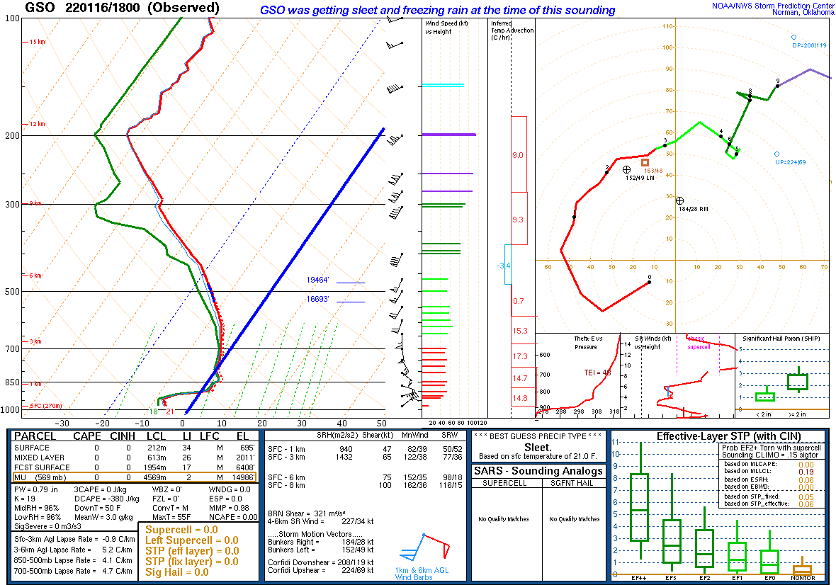
Sleet and Freezing Rain
...FREEZING RAIN REPORTS...

Location                     Amount    Time/Date       Provider

...North Carolina...

...Caswell County...
4 ESE Quick                  0.10 in   0930 PM 01/16   Public
3 WSW Semora                 0.04 in   0847 AM 01/17   Trained Spotter

...Rockingham County...
3 W Reidsville               0.01 in   0500 PM 01/16   Public
3 SW Lawsonville             0.01 in   0700 PM 01/16   Public

...Virginia...

...Appomattox County...
3 WNW Evergreen              0.01 in   1000 PM 01/16   Public
2 S Appomattox                T in     0915 AM 01/17   CO-OP Observer

...Bedford County...
2 WSW Boonsboro              0.25 in   0738 AM 01/17   Public
6 SSW Goode                  0.02 in   0636 AM 01/17   Trained Spotter

...Buckingham County...
1 NW Gold Hill               0.13 in   1017 PM 01/16   Public
2 W Dillwyn                   T in     0900 AM 01/17   CO-OP Observer

...Carroll County...
3 SSE Pipers Gap             0.10 in   0500 PM 01/16   Public

...City of Lynchburg...
3 E Boonsboro                0.10 in   0402 PM 01/16   Trained Spotter

...Floyd County...
2 ESE Willis                 0.10 in   0231 PM 01/16   Public

...Halifax County...
5 SE Brookneal               0.10 in   0816 AM 01/17   CO-OP Observer
2 ESE Ridgeway                T in     0953 AM 01/17   Public

...Rockbridge County...
4 WSW Buena Vista City       0.25 in   0900 PM 01/16   Trained Spotter

...West Virginia...

...Monroe County...
3 WNW Raines Corner           T in     0822 AM 01/17   CO-OP Observer

...SLEET REPORTS...

Location                     Amount    Time/Date       Provider

...North Carolina...

...Caswell County...
3 WSW Semora                 2.5 in    0847 AM 01/17   Trained Spotter
4 ESE Quick                  1.8 in    0941 PM 01/16   Public
1 NNE Camp Springs           1.2 in    0530 PM 01/16   Trained Spotter

...Rockingham County...
3 W Reidsville               2.0 in    0500 PM 01/16   Public
3 SW Lawsonville             1.0 in    0600 PM 01/16   Public
Reidsville                   0.8 in    0254 PM 01/16   Public
Madison                      0.2 in    0318 PM 01/16   Fire Dept/Rescue
Eden                         0.1 in    0200 PM 01/16   Public

...Stokes County...
Meadows                      0.5 in    0135 PM 01/16   Dept of Highways
Danbury                      0.5 in    0145 PM 01/16   911 Call Center

...Surry County...
4 NNW Pilot Mountain         0.1 in    0500 PM 01/16   Trained Spotter

...Virginia...

...Appomattox County...
2 WSW Tower Hill             1.0 in    0915 AM 01/17   Public

...Bedford County...
Stewartsville                1.0 in    0910 PM 01/16   Public

...Bland County...
Bland                        0.3 in    0900 PM 01/16   Trained Spotter

...Botetourt County...
1 SW Buchanan                1.0 in    0600 PM 01/16   Trained Spotter
Fincastle                    0.3 in    0500 PM 01/16   Broadcast Media

...Buckingham County...
2 W Dillwyn                  1.0 in    0900 AM 01/17   CO-OP Observer

...Carroll County...
2 SSE Byllesby               2.3 in    0809 AM 01/17   Trained Spotter
Fancy Gap                    0.5 in    0743 PM 01/16   Public

...City of Salem County...
2 NNE Salem City             1.0 in    0542 PM 01/16   Public
1 NW Salem City              0.1 in    0400 PM 01/16   Public

...Floyd County...
2 S Terrys Fork              1.5 in    0415 PM 01/16   Trained Spotter

...Grayson County...
1 NNW Mouth of Wilson        0.3 in    0330 PM 01/16   Public

...Halifax County...
1 ESE South Boston           0.8 in    0816 AM 01/17   CO-OP Observer

...Montgomery County...
Elliston                     1.0 in    1053 PM 01/16   Trained Spotter
2 SSE Pilot                  1.0 in    0415 PM 01/16   Public
2 S Pilot                    1.0 in    0630 PM 01/16   Trained Spotter
2 NE Blacksburg              0.7 in    1000 AM 01/17   NWS Employee
1 NNW Pilot                  0.3 in    0413 PM 01/16   Trained Spotter

...Pittsylvania County...
3 NNW Ringgold               1.5 in    0500 PM 01/16   Trained Spotter
4 WSW Dry Fork               1.3 in    1030 PM 01/16   Public

...Roanoke County...
1 SE Cave Spring             1.3 in    0700 PM 01/16   Public
3 SSW Laymantown             0.1 in    0300 PM 01/16   Public

...Rockbridge County...
3 NNE Rockbridge Baths       2.0 in    0300 AM 01/17   Trained Spotter
Vesuvius                     2.0 in    0855 AM 01/17   Public

...West Virginia...

...Mercer County...
1 SW Bluefield               1.0 in    0947 AM 01/17   CO-OP Observer
Bluefield                    0.5 in    1000 PM 01/16   Public
1 SSE Bluefield              0.5 in    0900 AM 01/17   Trained Spotter
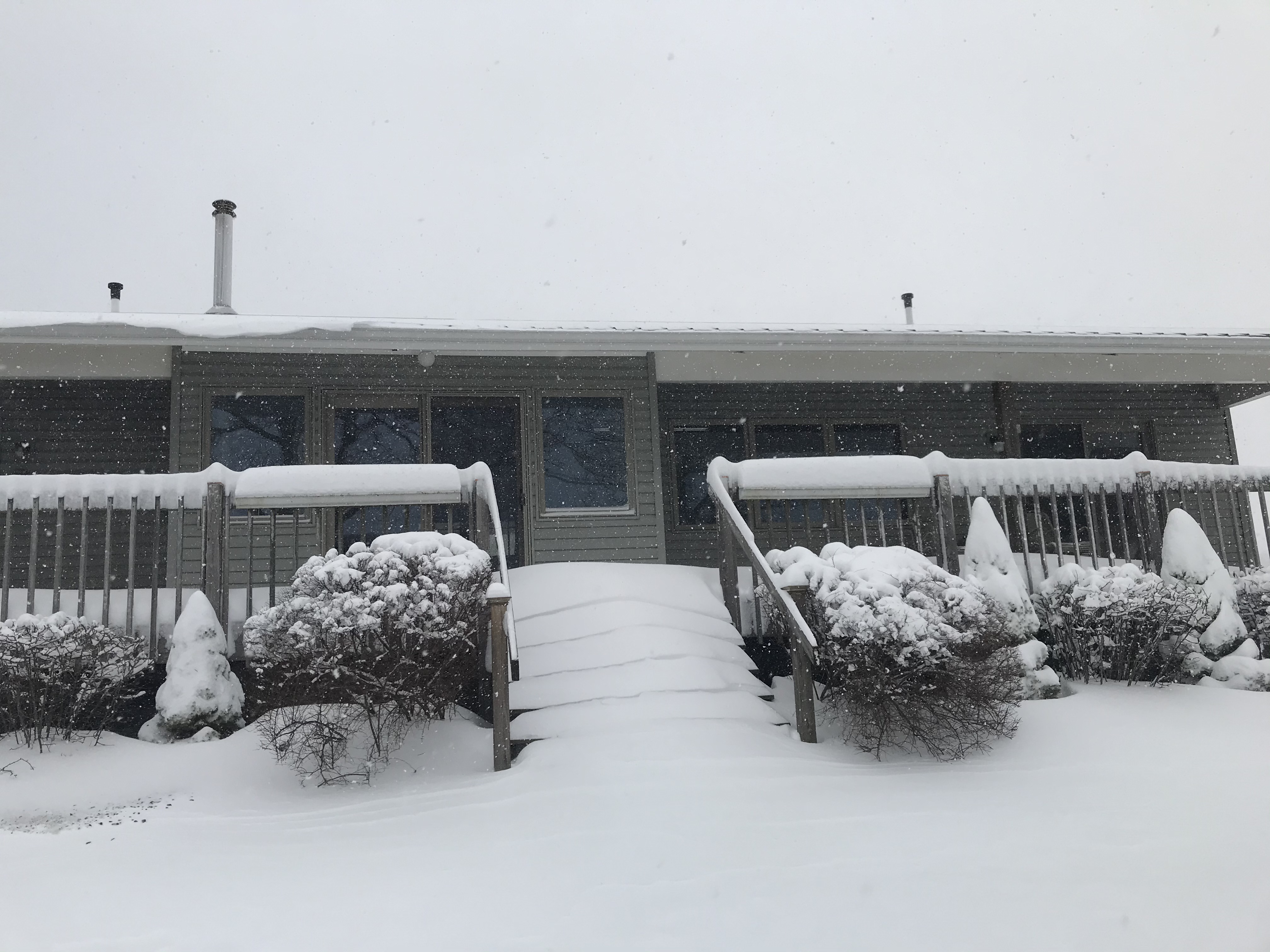
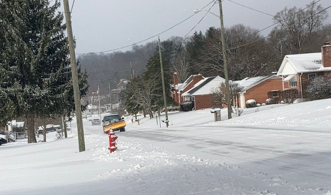
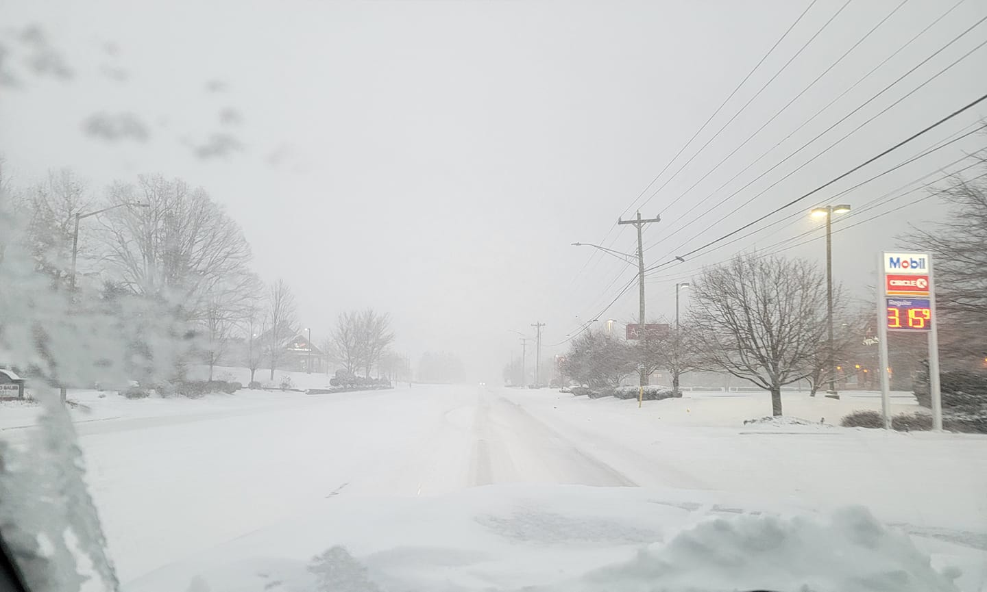
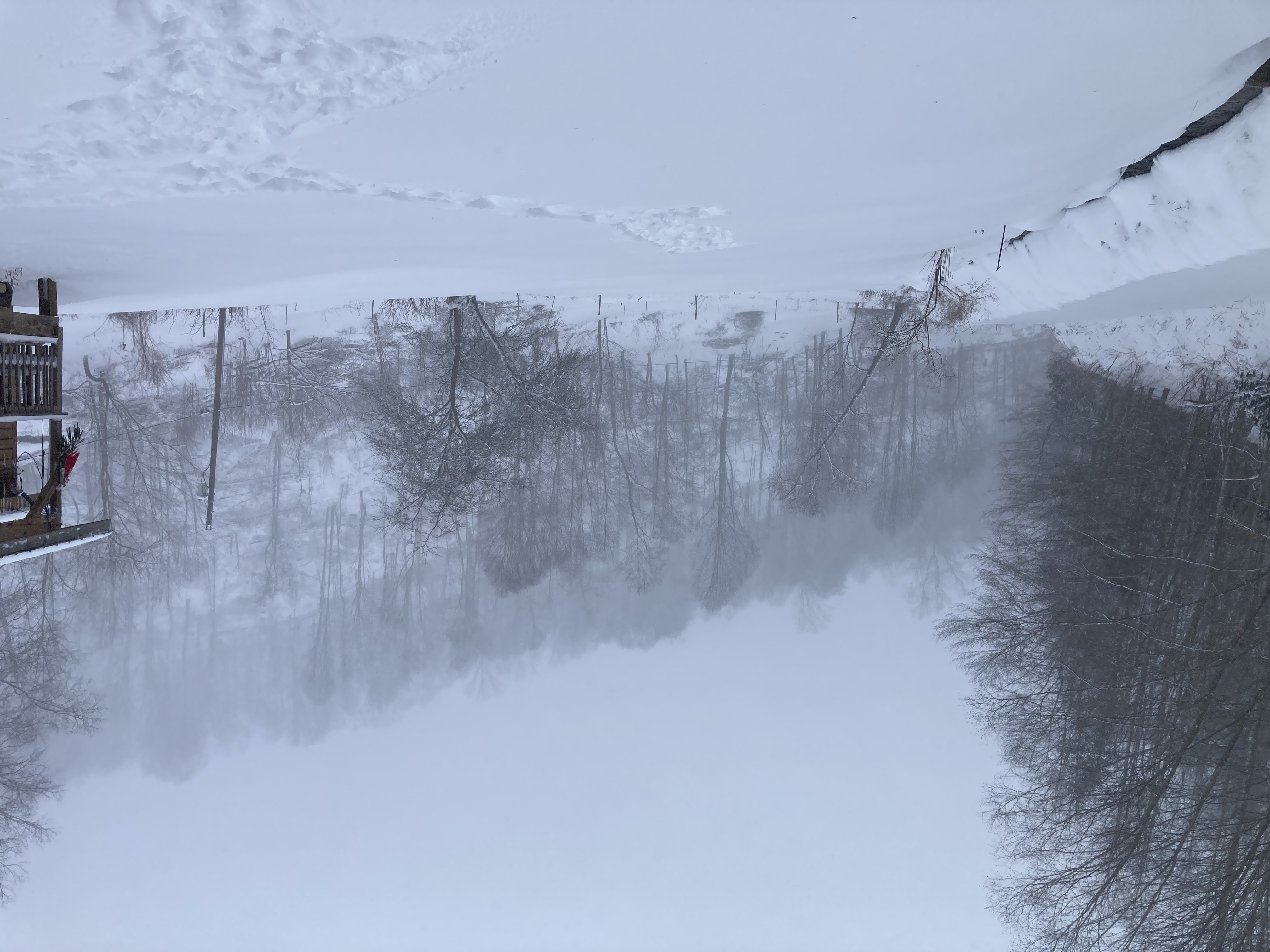
Photos
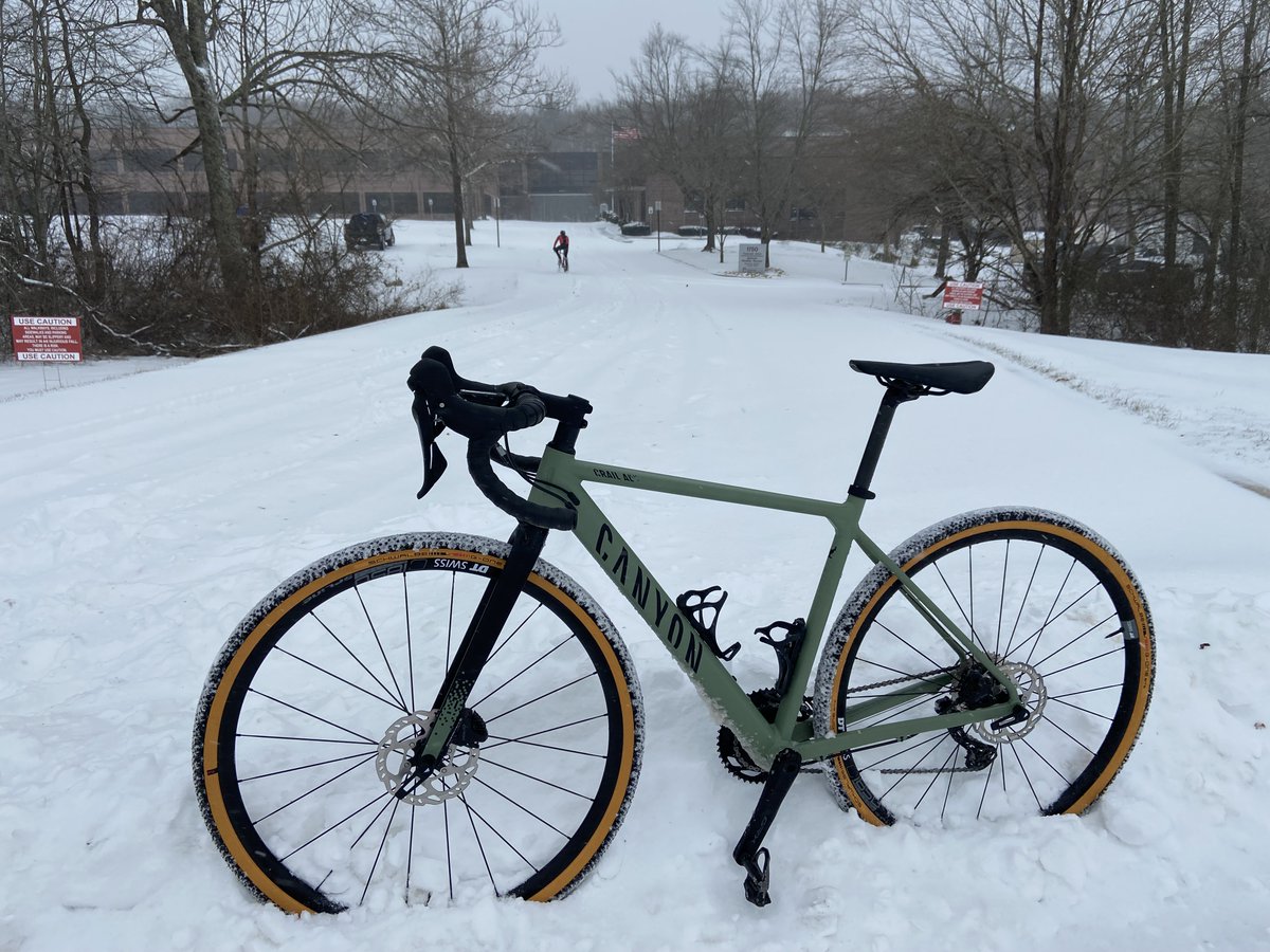 |
 |
 |
| NWS Blacksburg (Jesse Sadler) |
Renick, WV (David Ballard) |
Marion, VA (Michael Gibson) |
 |
 |
|
| Boone, NC (Teresa Tendstowingit) |
Creston, NC (Katrina Jones) |
Meteorology
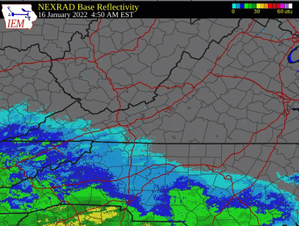
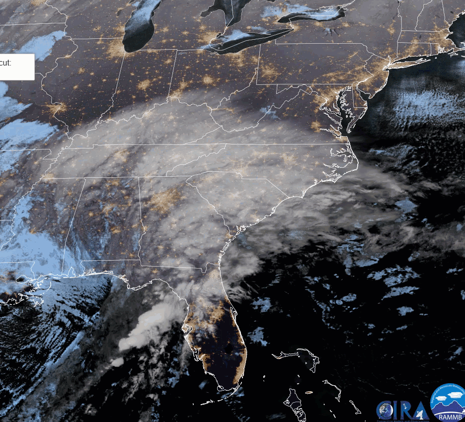
Winter forecasting remains one of the more challenging parts of meteorology. Several days to a week before the event, this system looked like it was going to be one low pressure area, and what we term Miller A, or just an overrunning event. This type of scenario usually produces a sharp gradient between rain and snow, with limited mixed precipitation. As we got closer, the evolution of the system took on a more Miller B scenario, with two low pressure systems. The first moving across the Gulf Coast into the Appalachians and weakening, and the second low taking over as the dominant one as it moved across the eastern Carolinas into eastern Virginia. This allowed warmer air to get pulled westward into the precipitation, changing snow to sleet and freezing rain, which cut snow amounts for most. Still the system performed well in terms of precipitation production. Click on the images below for radar and satellite loops, as well as upper air soundings from Blacksburg and Greensboro during the event, and the surface and 500 mb maps for each day.
 |
 |
 |
| Figure 1: Radar Loop of the Jan 16th storm (courtesy Iowa State) |
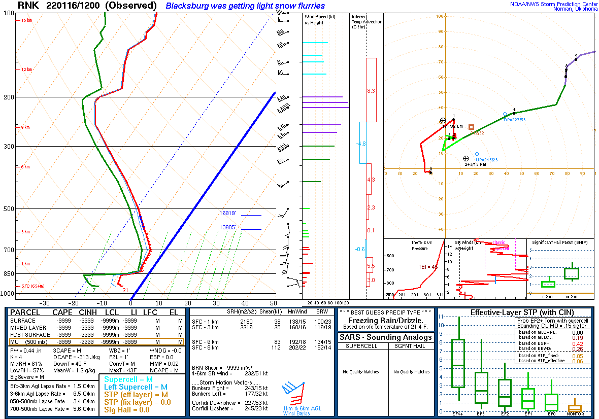
Figure 2: GOES East IR satellite loop of Jan 16th-17th storm | Figure 3: Blacksburg Sounding from 7am Sunday, Jan 16th. Thick blue line depicts the 0 C Isotherm. Everything left is below freezing, suggesting snow. |
 |
 |
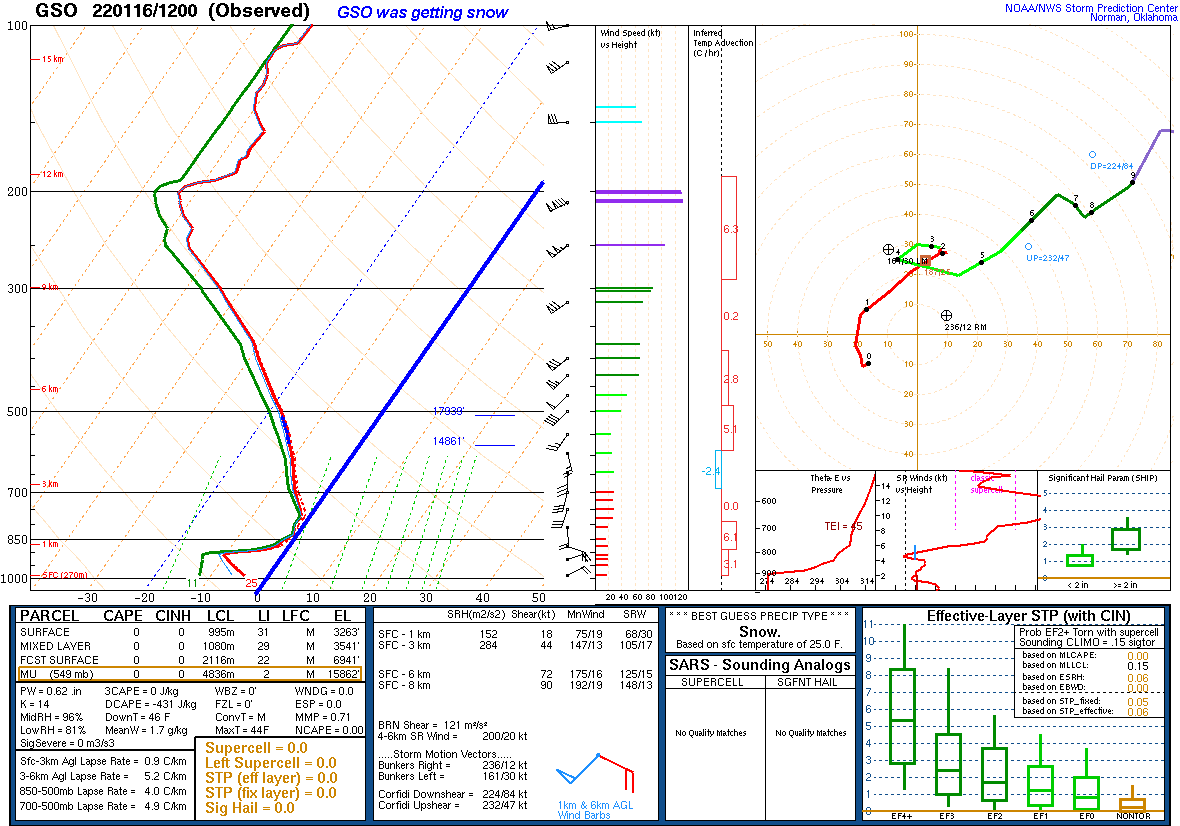 |
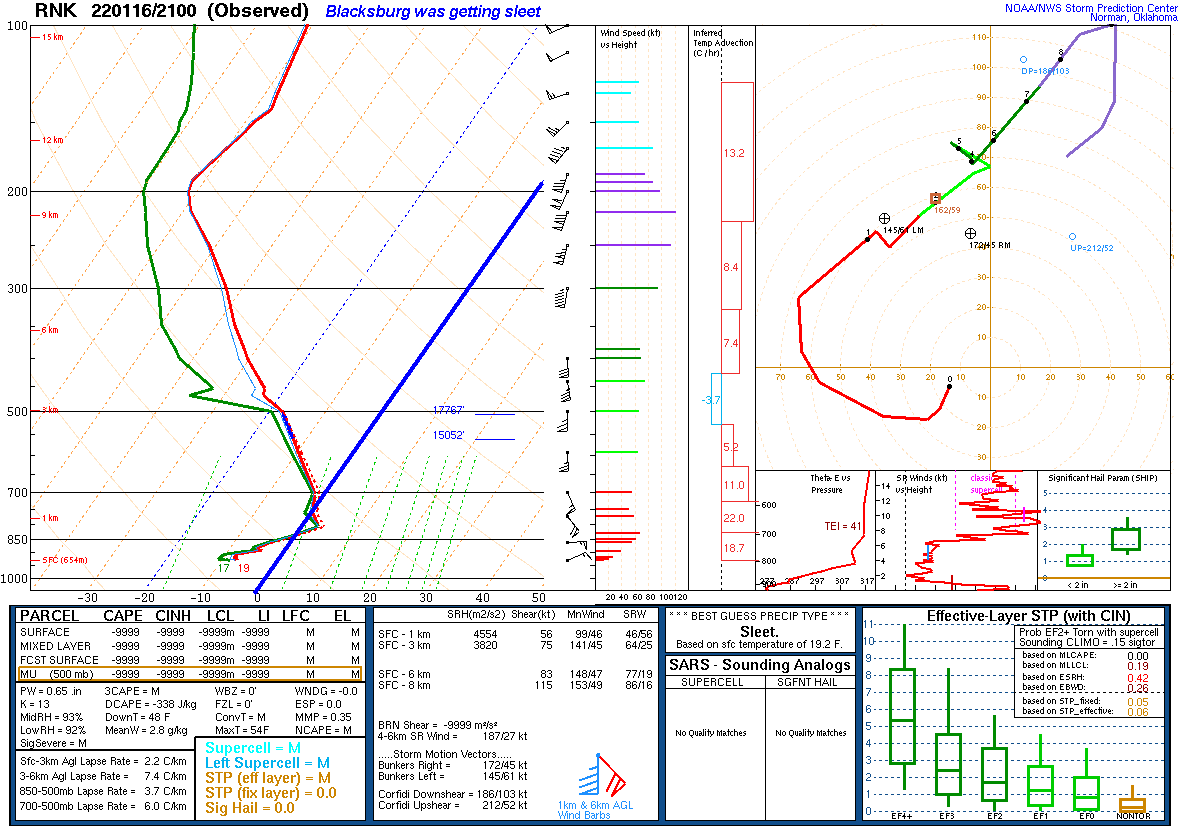
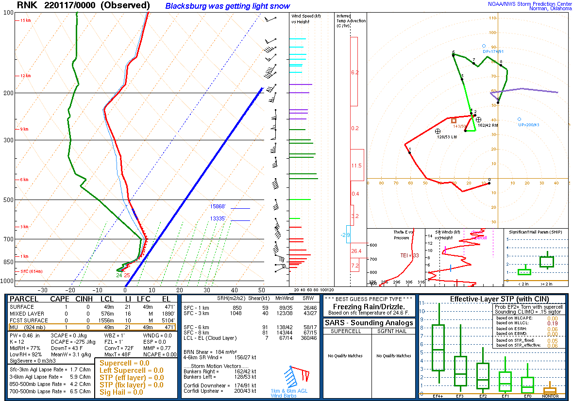
| Figure 4: Blacksburg Sounding from 4pm Sunday, Jan 16th. Thick blue line depicts the 0 C Isotherm. See the warm nose around 850mb. Sleet was falling at the time of this sounding in Blacksburg. | Figure 5: Blacksburg Sounding at 7pm, shows that colder air moved back in, but moisture aloft was decreasing so only light snow was falling at this time. | Figure 6: This is the 7am Sounding from Greensboro, NC. Snow was falling as you can see the entire sounding below freezing. |
 |
 |
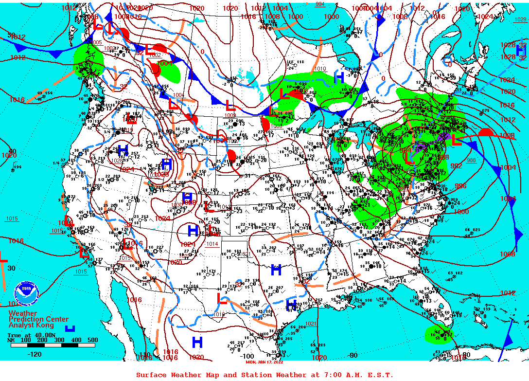 |
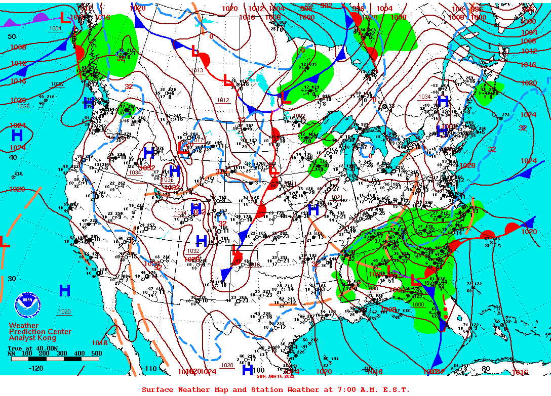
| Figure 7: At 1pm, the Greensboro sounding shows a warm nose around 850 mb, ~ 100mb deep. There was a mix of sleet and freezing rain at this time in that area. | Figure 8: 7am Sunday Jan 16th Surface Map. Two lows (Miller B), with cold high pressure wedging south from New England. | Figure 9: 7am Monday Jan 17th surface map, shows the storm system over the northern Mid-Atlantic and the northwest flow of moisture pushing into the mountains. |
 |
|
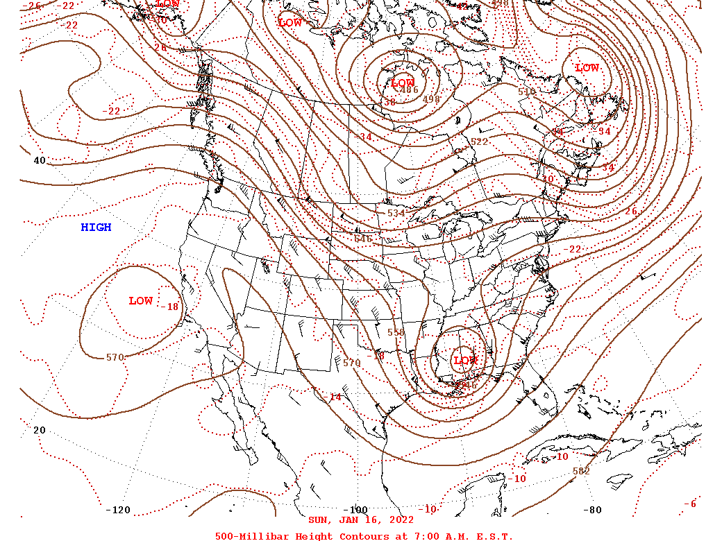
| Figure 10: 500 mb at 7am Sunday Jan 16th, shows closed low over MS/AL border, with good upper difluence over the central and southern Appalachians, with plenty of moisture feeding in on southerly flow. | Figure 11: 7am Monday at 500 mb shows the closed low over PA. |
For any questions regarding this storm, or winter storms in particular, feel free to email us at rnk.webmaster@noaa.gov
 |
Media use of NWS Web News Stories is encouraged! Please acknowledge the NWS as the source of any news information accessed from this site. |
|

