Overview
The heaviest snows in Pennsylvania typically come from "Lake Effect," "Nor'easters," "Alberta Clippers," and "Squall Lines."
If you click on the thumbnail images you can see the full-scale image (below).
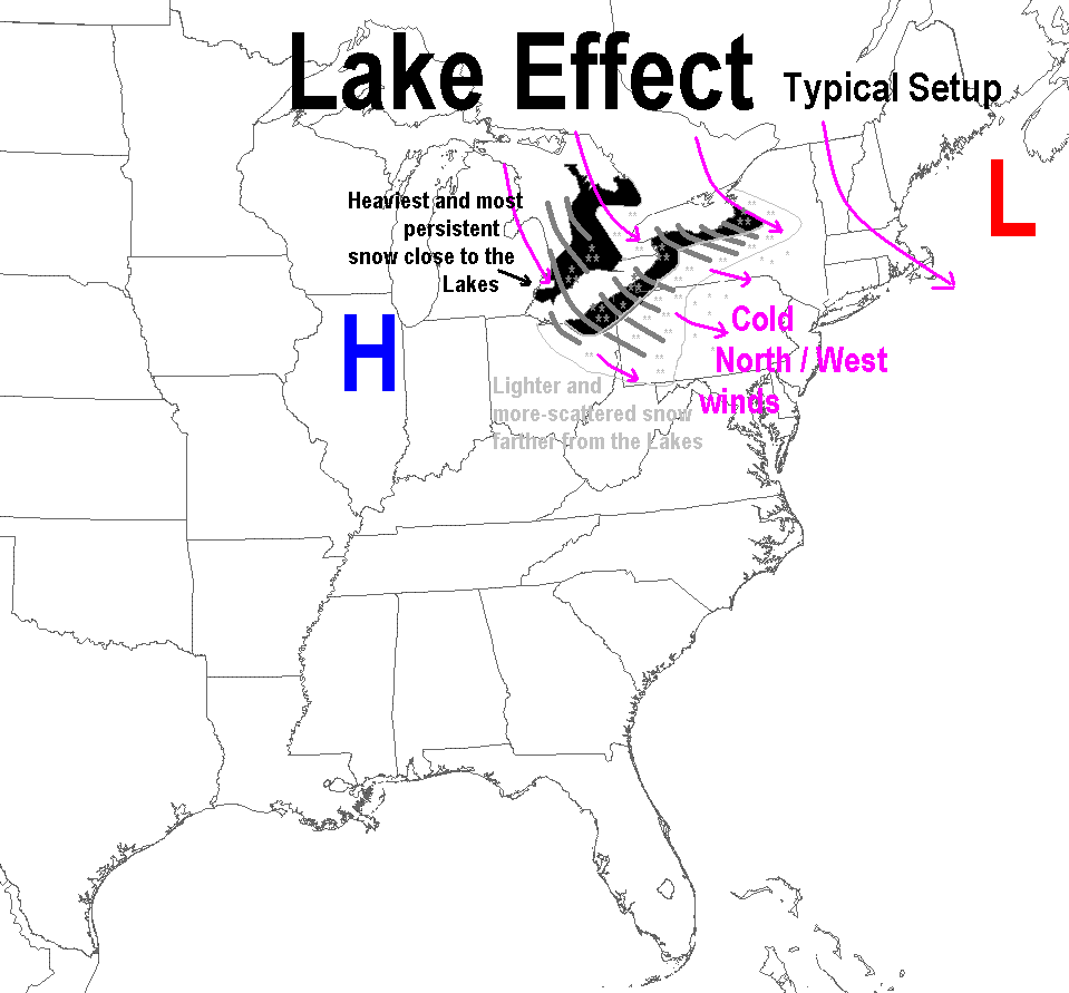
* Lake Effect
 Lake Effect snow is generated when very cold air moves across the Great Lakes and picks up extra moisture and warmth from the relatively warmer lakes. This process can be slowed or stopped if the lake(s) freeze over. Lake Erie is normally the only Great Lake (excepting Lake St. Clair) which will freeze over almost entirely by the end of the winter. However, when there is open water, the added warmth and moisture create shallow convection and snow showers, known as Lake Effect snow. Lake Effect snow is generated when very cold air moves across the Great Lakes and picks up extra moisture and warmth from the relatively warmer lakes. This process can be slowed or stopped if the lake(s) freeze over. Lake Erie is normally the only Great Lake (excepting Lake St. Clair) which will freeze over almost entirely by the end of the winter. However, when there is open water, the added warmth and moisture create shallow convection and snow showers, known as Lake Effect snow.
Lake Effect typically makes the heaviest snows over a long time period in the NW (also known as the Lake Effect Snow Belt), but the heavy snow forms in bands that are very narrow, and could sit in place for a long time or waggle in many directions throughout the event. These narrow bands could produce extremely heavy snow on that one stretch of highway while, just a mile down the road, the sun can be out. Also, a band of snow could set up all along a stretch of highway parallel to it, and make that whole stretch of road treacherous.
* Nor'easters
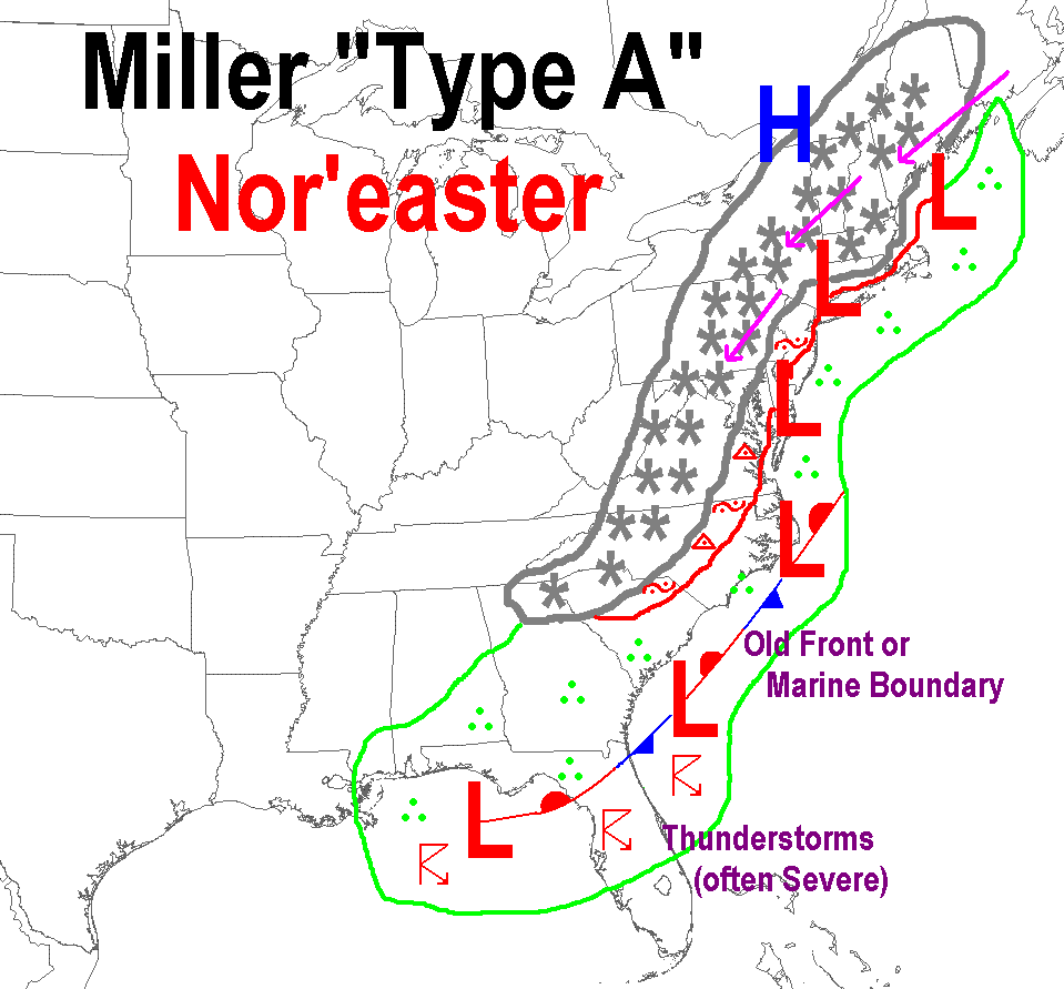
A Nor'easter is a storm characterized by a central low pressure area that deepens dramatically as it moves northward along the U.S. East Coast. The name came from the strong northeast winds that precede and accompany the storm as it passes over New England. Nor'easters are notorious for producing heavy snow in the Central and Northeastern Mountains (including the Poconos), but typically make lighter snow (or even no snow) for counties in the west. Nor'easters will usually produce a heavy, wet snow. There is usually a fairly consistent demarcation between rain, mixed precipitation, and snow which moves along with the storm and generally parallel to the track of the surface low. The demarcation typically pivots with the storm as the track changes direction. The mixed precipitation and rainfall are generated when warmer marine air is pulled into the storm. The heaviest snow in a Nor'easter falls to the north and west of the track of the surface low.
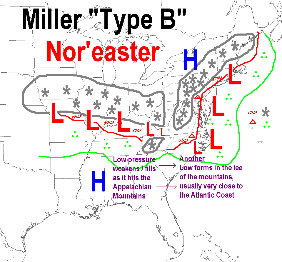
Nor'easters can be classified into one of two categories, named after the researcher (J.E. Miller) who first came up with this classification system for East Coast snow storms in 1946:
 1) Nor'easters that develop primarily on the Gulf Coast or East Coast along an old cold front, or along the marine/land airmass contrast found on the East Coast, could be considered "classic" Nor'easters. Storms that develop in this manner are referred to as "Miller Type-A" storms. The "Superstorm of March 1993" is considered to have been a "Miller Type-A" storm. 1) Nor'easters that develop primarily on the Gulf Coast or East Coast along an old cold front, or along the marine/land airmass contrast found on the East Coast, could be considered "classic" Nor'easters. Storms that develop in this manner are referred to as "Miller Type-A" storms. The "Superstorm of March 1993" is considered to have been a "Miller Type-A" storm.
 2) Storms that come in from the west (up the Ohio Valley) are usually referred to as "Miller Type-B" storms. These storms produce precipitation in the Midwest/Ohio Valley and have a defined surface low that is moving toward the Appalachian Mountains from the west. As these storms approach the mountains, they lose their coherent/compact surface low center and the low re-develops along the East Coast. When this re-development (a.k.a. "center-jump") happens, the storm can still produce snow over all of the state. But, it will usually produce the most/heaviest/longest snow in NE PA (Potter Co. and east). 2) Storms that come in from the west (up the Ohio Valley) are usually referred to as "Miller Type-B" storms. These storms produce precipitation in the Midwest/Ohio Valley and have a defined surface low that is moving toward the Appalachian Mountains from the west. As these storms approach the mountains, they lose their coherent/compact surface low center and the low re-develops along the East Coast. When this re-development (a.k.a. "center-jump") happens, the storm can still produce snow over all of the state. But, it will usually produce the most/heaviest/longest snow in NE PA (Potter Co. and east).
Storms that approach from the west ("Miller Type-B") typically move through Pennsylvania faster than Nor'easters, and produce a widespread and more-evenly distributed snowfall (everyone gets a similar amount) versus the "Miller Type-A" storms, and Lake Effect events.
Most Nor'easters tend to produce mixed precipitation in some part of PA, mainly in the Southeast, but the "Miller Type-B" storms have a better chance to do so due to the typical thermal pattern present (warm air closer to the State).
* Alberta Clippers
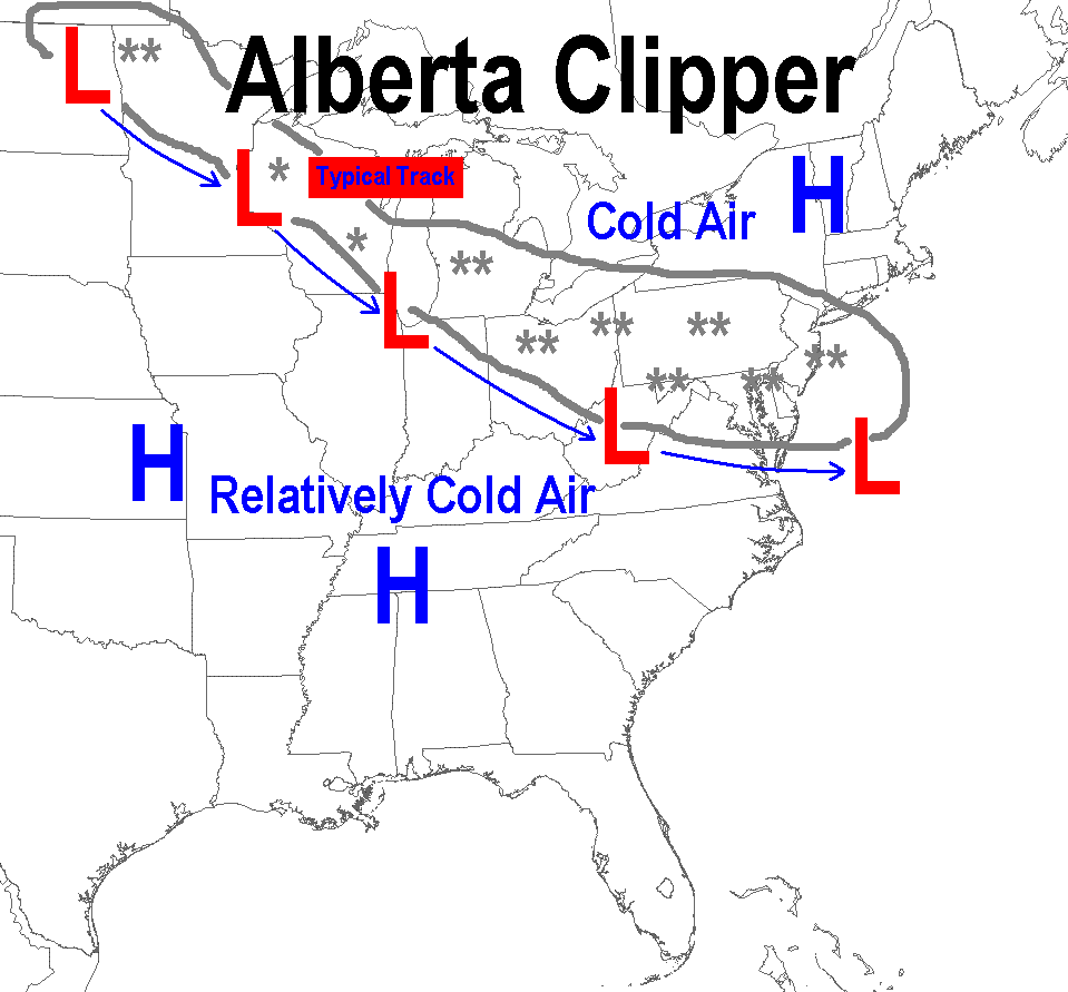
The other typical snow-producer for PA: Alberta Clippers (or "Clippers").
 Clippers are very fast-moving storms that drop down from the NW across the Great Lakes from Central Canada (Alberta Province), and produce evenly-distributed snowfalls. Clippers tend to make less snow than do Nor'easters, but the snow can be very fluffy and pile up/be tough to clear, due to the low/dry water-content of the snow. Since it is already very cold when the Clippers move through, it is rare to get other precipitation types than snow. They are almost always pure snow. Clippers are very fast-moving storms that drop down from the NW across the Great Lakes from Central Canada (Alberta Province), and produce evenly-distributed snowfalls. Clippers tend to make less snow than do Nor'easters, but the snow can be very fluffy and pile up/be tough to clear, due to the low/dry water-content of the snow. Since it is already very cold when the Clippers move through, it is rare to get other precipitation types than snow. They are almost always pure snow.
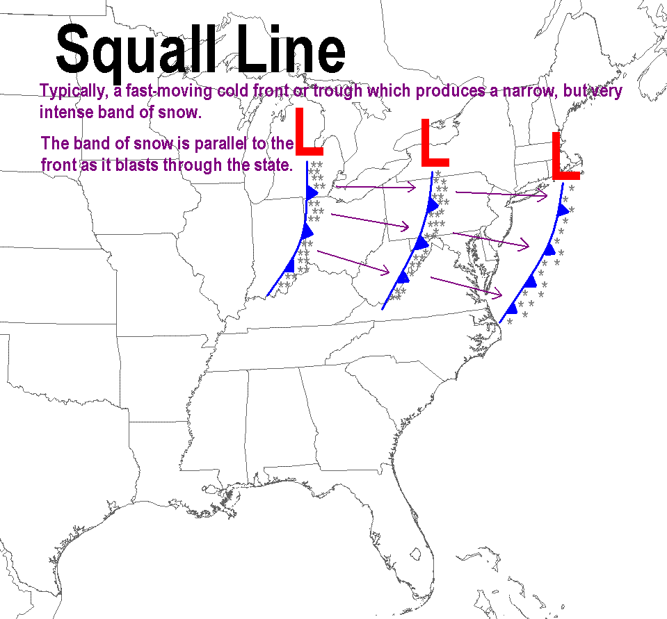
* Squall Line
 A more-unusual snow-producing weather system would be a "Squall Line" along a distinct cold front, or trough of low pressure at the surface, which moves through with relatively cold air already in place. The squalls will usually be at the very leading edge of very cold air masses, and to the south of a larger shield of snow. These squall lines usually have a strong upper-level cyclone driving the front and can generate instability. This instability leads to convective snow showers much like thunderstorms happen in the summer. Only these winter snow squalls are much more shallow/shorter than summer thunderstorms. These intense squall lines resemble the heaviest lake effect bands in width and intensity, but move steadily west to east, and pack strong winds as they move through. A more-unusual snow-producing weather system would be a "Squall Line" along a distinct cold front, or trough of low pressure at the surface, which moves through with relatively cold air already in place. The squalls will usually be at the very leading edge of very cold air masses, and to the south of a larger shield of snow. These squall lines usually have a strong upper-level cyclone driving the front and can generate instability. This instability leads to convective snow showers much like thunderstorms happen in the summer. Only these winter snow squalls are much more shallow/shorter than summer thunderstorms. These intense squall lines resemble the heaviest lake effect bands in width and intensity, but move steadily west to east, and pack strong winds as they move through.
Because of the intensity of the snow in these squall lines, they can create very dangerous driving conditions with white-outs (no visibility) and wind-driven snow that accumulates again as soon as the snow plow crews clear it away. Many of these squall lines have caused chain-reaction accidents on the interstate roadways.
** Caveats
Elevation will almost always play a role in how much snow/ice each location will receive in these storms. Trying to time precipitation changes is very difficult due to the uncertainty of the surface low track, and therefore the thermal characteristics of the 3-dimensional storm. Many early- and late-season storms will only produce snow in the higher elevations of the state, since the air in the valleys is too warm.
** Seasonal Totals and Snowfall Averages/Normals
You can find a seasonal normals/averages map under the "Snowfall Info" tab on our https://www.weather.gov/ctp/moreWater page. Under the "Seasonal Normals" section of the Snowfall Info tab, you can find instructions on how to pull snowfall normals for specific places directly from the database for individual observing locations.
Not all of our co-operative observing stations report snowfall, but most do. Here is an example from Glen Hazel (Northern Elk Co, near E Branch Dam):
GLEN HAZEL 2 NE DAM (363311)
Monthly Totals/Averages
Snowfall (inches)
Years: 1971-2001

             Jul   Aug   Sep   Oct   Nov   Dec   Jan   Feb   Mar   Apr   May   Jun  Season
Average      0.0   0.0   0.0   0.2   6.5  17.4  19.0  13.7  12.0   2.2   0.1   0.0    71.2
|
