When we obtain reports from across the region - whether from spotters, the general public, or solicited information from people like PennDOT or Emergency Personnel - we quality-check the data. We then try to issue Public Information Statements that summarize this information. Latest 24-hr Snowfall Report Map
410
NOUS41 KCTP 202000
PNSCTP
PAZ026-210000-
Public Information Statement
National Weather Service State College PA
400 PM EDT Mon Jul 20 2026
...NWS Damage Survey for 07/18/26 Tornado Event...
.Overview...
A damage survey conducted on Monday July 20th confirmed an EF-2
tornado occurred in Franklin Township, Huntingdon County on the
evening of Saturday July 18, 2026. The tornado damaged a few
structures and produced significant tree damage along and just
south of Old Mill Rd. Details of the survey follow.
Start Date: 07/18/2026
Start Time: 08:43 PM EDT
Start Location: 3 NNE Spruce Creek / Huntingdon County / PA
Start Lat/Lon: 40.6551 / -78.116
End Date: 07/18/2026
End Time: 08:45 PM EDT
End Location: 2 W Franklinville / Huntingdon County / PA
End Lat/Lon: 40.6531 / -78.1063
Survey Summary:
The same storm that produced the tornado in Houtzdale (Clearfield
County) continued southeast into Huntingdon County on Saturday
evening. It started producing minor damage again as it crossed
Huntingdon Furnace Road just northwest of Turnpike Rd as it
knocked down some corn stalks. Strong downdraft winds knocked down
several 200+ year old pine trees in front of a farm house on
Huntingdon Furnace Rd along with a couple smaller trees in the
farm field and then the tornado began moments later.
The first structural damage was observed as the roof of the oldest
of 3 large silos was partially blown off toward the northeast,
exhibiting a cyclonic wind pattern. The southern half of a large
barn roof collapsed and was blown northeast as well. An adjacent
barn had several sheets of its tin roof blown northeast into the
adjacent field as well. The circulation then continued east-
southeast paralleling Warriors Mark Run and Old Mill Rd and
produced an incredible amount of tree damage as it moved up a
small ridge. Hundreds of trees were snapped off 20-30 feet up or
uprooted along the path of the tornado. Notably, trees were thrown
in an easterly direction to the right of the tornado path and
northwesterly to the left of the path. This pattern, along with
the evident path of damage left no doubt that the damage was
caused by a tornado.
There were also several cabins in the densely wooded area through
which the tornado passed. One cabin, which was inhabited by two
individuals in their 80s, had a tree fall on one side of it.
Fortunately, both individuals were safely sheltered on the
opposite side of the house and were able to escape unscathed. The
other cabins suffered no damage, though inhabitants were unable to
enter or exit the camp until significant clearing efforts were
undertaken. The tornado continued east- southeastward toward Camp
Kanesatake and lifted as it moved across Old Mill Rd on the north
edge of the camp. Sporadic tree damage was observed downstream at
Camp K, but none of it was concentrated enough to extend the
tornado path at this time.
We would like to thank Huntingdon County Emergency Management and
Franklin Township for their assistance with today`s survey.
&&
EF Scale: The Enhanced Fujita Scale classifies tornadoes into the
following categories:
EF0.....65 to 85 mph
EF1.....86 to 110 mph
EF2.....111 to 135 mph
EF3.....136 to 165 mph
EF4.....166 to 200 mph
EF5.....>200 mph
NOTE:
The information in this statement is preliminary and subject to
change pending final review of the event and publication in
NWS Storm Data.
$$
Co-Operative (CoOp) Station Observations (Daily)
Once per day (usually around 7 am) more than 100 people across Central Pennsylvania send the NWS an observation covering the past 24 hours. Most report rain and snow totals. See the daily data from the CoOperative Observers
Daily Hydrometeorological Data Summary
National Weather Service State College PA
1113 AM EDT Wed Jul 22 2026
TEMPERATURE AND PRECIPITATION FOR THE PAST 24 HOURS.
TEMPERATURE SNOW
STATION OBSTIME PRECIP MAX MIN OBSN NEW TOTAL
Adams County
Biglerville 7am 0.09 84 66 68 M M
Cashtown 7am M M M M M M
Blair County
Altoona 7am 0.17 78 63 70 0.0 0
Altoona Airport 7am 0.21 77 64 69 M M
Tyrone 7am M M M M M M
Williamsburg 715am M 80 67 70 M M
Cambria County
Ebensburg 8am M M M M M M
Ebensburg 1SW 7am 0.23 M M 64 M M
Johnstown Airport 7am 0.21 73 63 63 M M
Prince Gallitzin 630am M M M M M M
Cameron County
Stevenson Dam 7am 0.23 76 60 65 0.0 0
Centre County
Philipsburg 2S 7am 0.06 75 63 64 M M
State College 8am 0.05 76 67 69 0.0 0
Clearfield County
Clearfield 7am 0.16 74 64 64 M M
Dubois 630am 0.43 M M M 0.0 0
Grampian 8am M M M M M M
Clinton County
Lock Haven 7am 0.20 77 65 67 0.0 0
Renovo 7am 0.14 77 63 66 0.0 0
Cumberland County
Carlisle 7am 0.02 81 65 67 0.0 0
Shippensburg 12am M M M M M M
Dauphin County
Harrisburg 7am M 84 72 72 M M
Harrisburg 1 NE 7am M M M M M M
Elk County
Ridgway 7am 0.80 75 47 60 0.0 0
Harford County MD
Conowingo Dam MD 7am M M M M M M
Huntingdon County
Raystown Lake 7am 0.13 81 69 73 M M
Lancaster County
Holtwood 7am M M M M M M
Lancaster 12am M M M M M M
Lancaster Airport 7am 0.01 85 68 72 M M
Millersville 7am M M M M M M
New Holland 12am M M M M M M
Safe Harbor 7am 0.97 83 71 72 M M
Lebanon County
Lebanon 2W 12am M M M M M M
Fort Indiantown Gap 7am M M M M M M
Lycoming County
Williamsport 7am 0.16 79 70 70 M M
Mckean County
Bradford 8am 0.50 74 57 59 0.0 0
Bradford Airport 7am 0.62 70 56 56 M M
Kane 7am M M M M M M
Mifflin County
Lewistown 7am 0.06 82 66 66 0.0 0
Northumberland County
Sunbury 7am 0.00 82 66 68 M M
Potter County
Coudersport 1SW 7am M M M M M M
Galeton 8am M M M M M M
Schuylkill County
Mahanoy City 7am 0.13 78 65 66 0.0 0
Pine Grove 7am 0.03 M M 66 0.0 0
Snyder County
Selinsgrove 7am M M M M M M
Selinsgrove Airport 7am M 82 68 71 M M
Somerset County
Confluence 7am 1.95 77 61 67 M M
Glencoe 7am 1.80 M M M M M
Hidden Valley 8am M M M M M M
Laurel Summit 7am M M M M M M
Somerset 7am 0.63 M M 63 0.0 0
Windber 7SE 7am M M M M M M
Sullivan County
Laporte 7am 0.07 73 62 63 M M
Tioga County
Covington 7am M M M M M M
Cowanesque Dam 7am 0.20 76 59 65 M M
Tioga Hammond Dam 7am 0.19 76 64 65 M M
Wellsboro 7am M M M M M M
Union County
Lewisburg 7am 0.00 79 65 68 0.0 0
Warren County
Kinzua Dam 7am M M M M M M
Warren 7am 0.60 75 57 57 M M
York County
New Cumberland 7am 0.15 84 72 72 M M
Thomasville 7am 0.09 86 69 74 M M
$$
Martin
Seasonal Totals
Select Season:
Tip: right click on image above and open in a new window to see the image full-sized (1032x700px)
Seasonal Normals
What is normal (average) for my location?
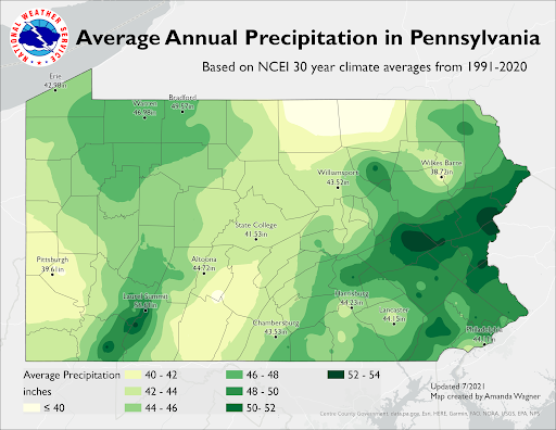
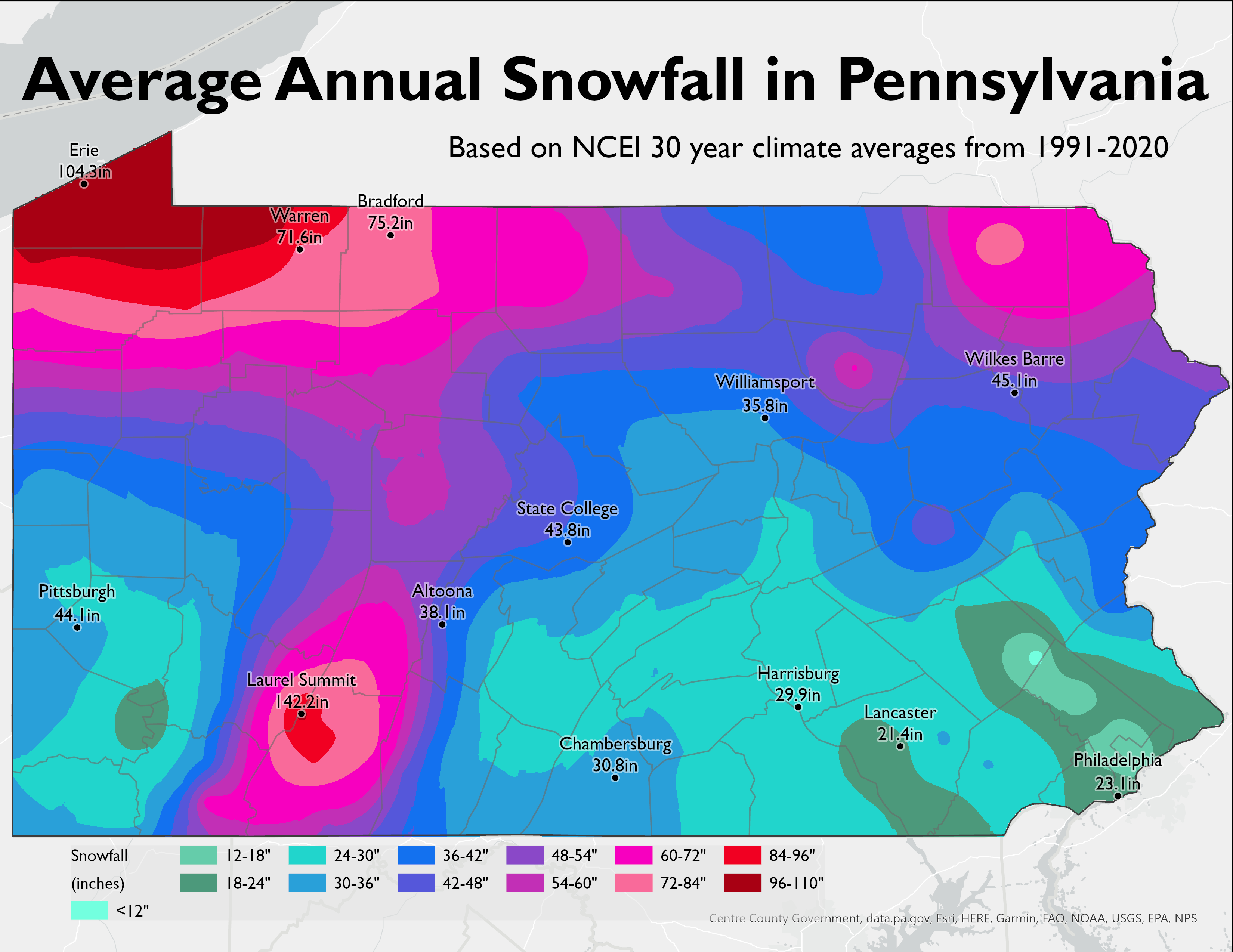
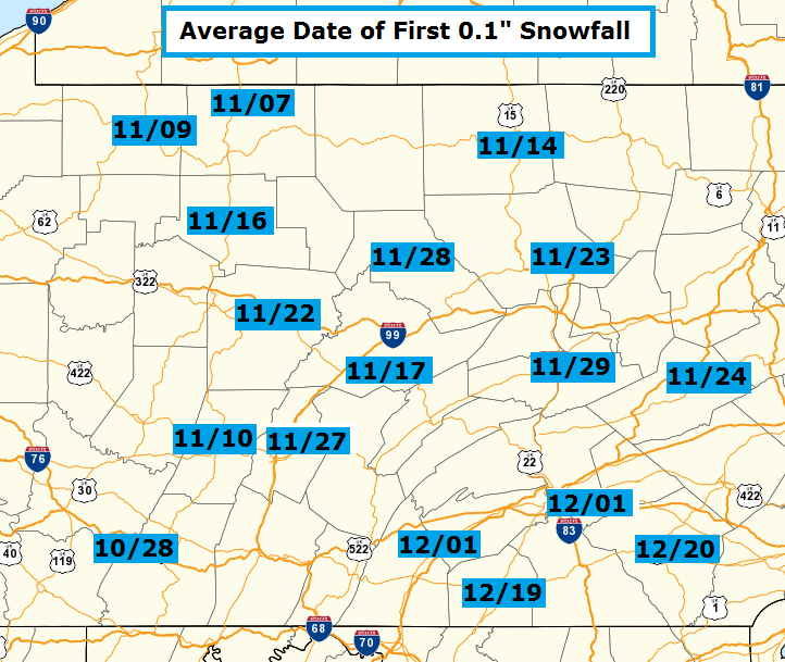
Check the map below, which lists the Average Annual Snowfall for Pennsylvania. Then, if you need further/more-detailed (monthly averages) information, check the Climate Database for a location near you.
Select:
"Monthly avgs/totals" from Col #1 (Product)
Choose a location near to you from Col #2 (Location)
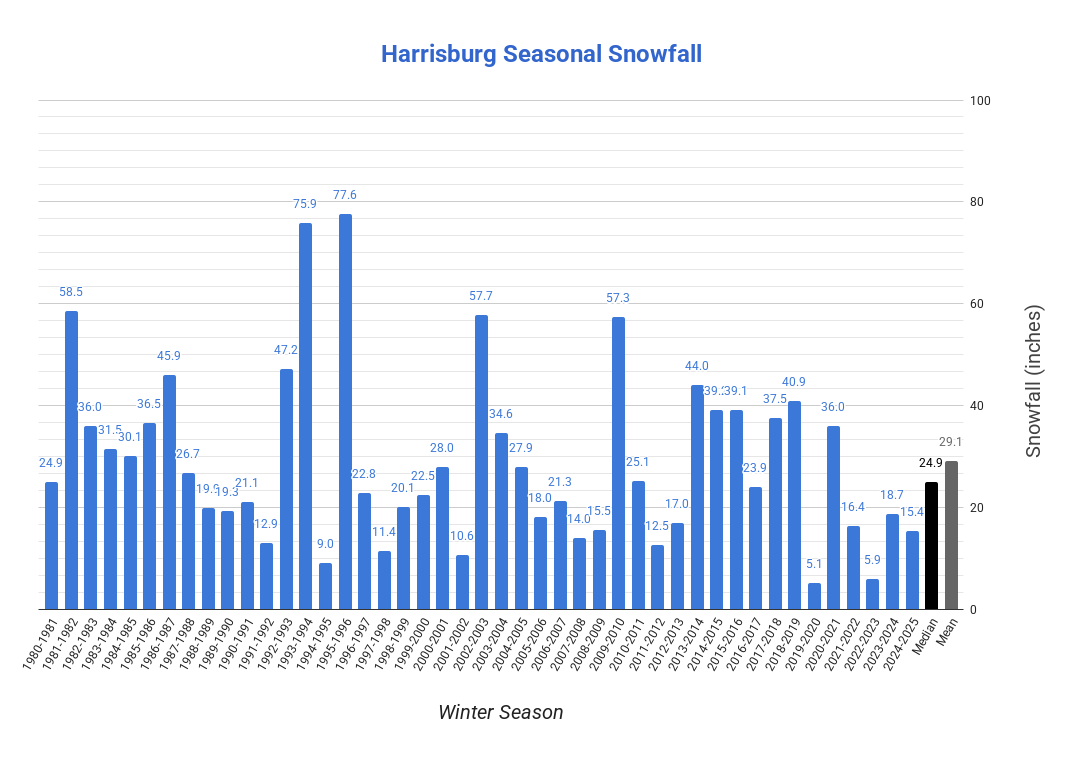
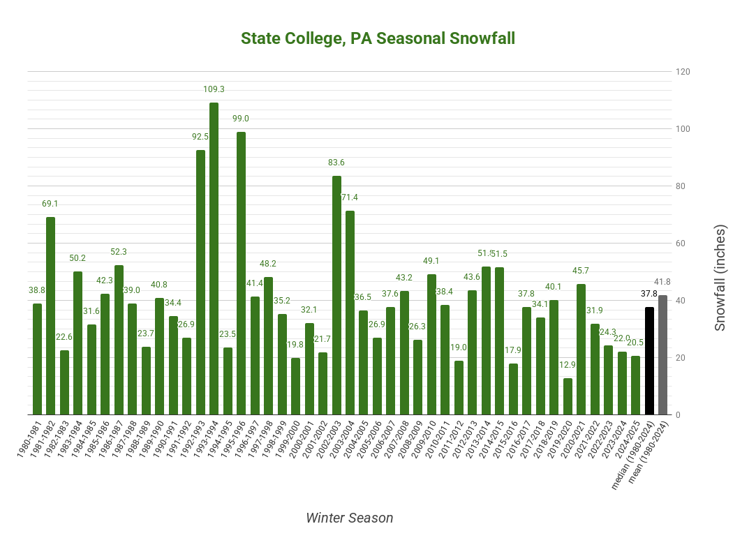
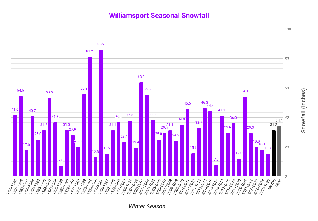
The following charts show the individual winter season snowfalls since 1980-1981. Continuous weather records have been kept since 1888 in Harrisburg, and since 1895 in both Williamsport and State College. Scroll down to see the larger images.
Harrisburg, PA Site Snowfall for recent winter seasons.
State College, PA Co-Operative Observation Site Snowfall for recent winter seasons.
Williamsport, PA Site Snowfall for recent winter seasons.
Laurel Summit, PA Co-Operative Observation Site Snowfall for recent winter seasons.


 Send Us a Report