On this page you learn what types of flooding are typical in Virginia and how do you protect yourself, your family and your home. You will also find out more about significant Virginia floods. Finally, you'll find links to NWS offices that provide forecast and safety information for Virginia as well as links to our partners who play a significant role in keeping you safe.
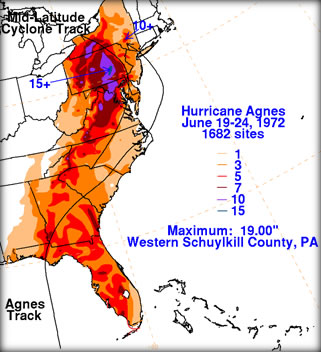
This rainfall triggered historic flooding across the Potomac River basin, the James River basin and portions of the Roanoke River Basin. At least 11 river gage locations measured water levels that were all-time record high levels and 30 locations in these basins measured crest there were in the top 10 all time. At the peak of the flooding, over 600 miles of highways were under water. Nearly 4,400 homes were damaged, with 95 being destroyed.
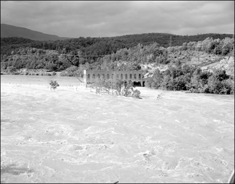
Historic flooding occurred on the James River in Richmond, where nearly a sixth of the town was under water. Four of the five bridges that cross the James River into Richmond were destroyed and the water supply, sewage treatment, electric and gas plants in town were all flooded.
In Scottsville, just 3 years after flooding from Camille, the city was again inundated with flood waters from the James River. The Scottsville Museum web site wrote “Bruce’s Drugstore on Valley and West Main Streets went under more than 12 feet of water!”
Devastating flooding also occurred on the Potomac River basin. A crest of 22 feet was reached at Little Falls, 10 feet above flood stage but about 3 feet below the record flood of March 1936. Numerous homes in the Seneca area were badly damaged, as were recreational facilities along the river.
Overall, Agnes caused damage in the neighborhood of $222 million dollars (1972 dollars) along with 13 fatalities.
|
|
|
|
|
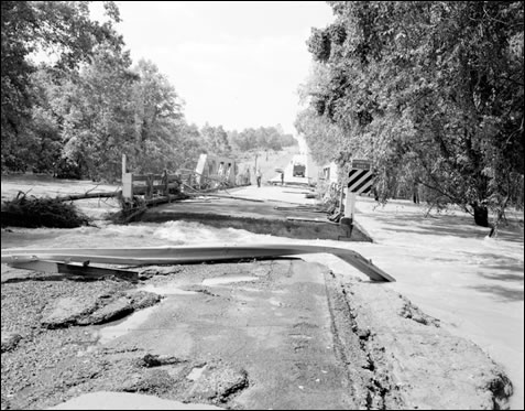
The bridge over the Appomattox River on Rt. 15 near Farmville |
|
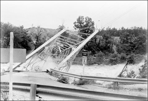
The Rt. 1 Bridge over the Occoquan River sways under the pressure of flood waters |
Learn More:
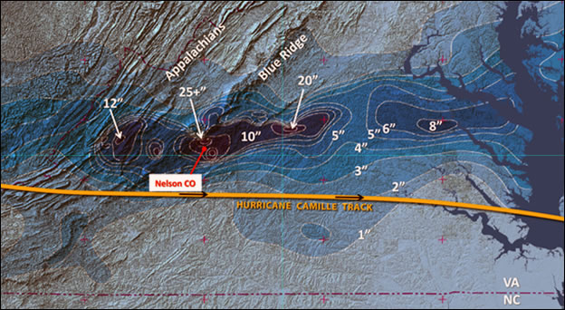
Rain swath created during Camille's transit across the Mid Atlantic; rain contours in inches: Tom Rabenhorst, UMBC, adapted from F. Schwartz, 1970, Monthly Weather Review
As a result of this rain, rivers and streams exploded with rapid water rises. Top soil in the higher terrain gave way, leading to massive mudslides, taking a large numbers of large trees. The trees and mud served to create temporary dams, which, when they broke, led to massive walls of water moving downstream with rapid water level rises that trapped people in their homes, destroyed buildings and bridges and often separated family and friends.
When the rain ended during the morning hours of the 20th, the state had whole towns under water or swept away. In Nelson County alone, the death toll was 123. As the flood waters moved into the James River, from the Tye and Rockfish rivers, the water level rises pushed the James River into the major flood category. All gaging stations east of Holcomb Rock near Lynchburg recorded either the 2nd or 3rd highest water level in recorded history. In Richmond, the James crested at height of 28.60 ft., which was surpassed only during Hurricane Agnes (1972) and the Election Day floods in 1985. At Palmyra, on the Rivanna River, the river reached a record height of 39.85 ft. (flood stage 17 ft.), and at Buena Vista, the Maury River reached a record height of 31.23 ft. (flood stage 17 ft.). As a result of the damage and flooding, all communication between Richmond, the capital of Virginia, and the Shenandoah Valley was cut off, slowing any assistance. Overall, 153 deaths were attributed to the flooding from Camille with damage estimated between $113–$140 million dollars.
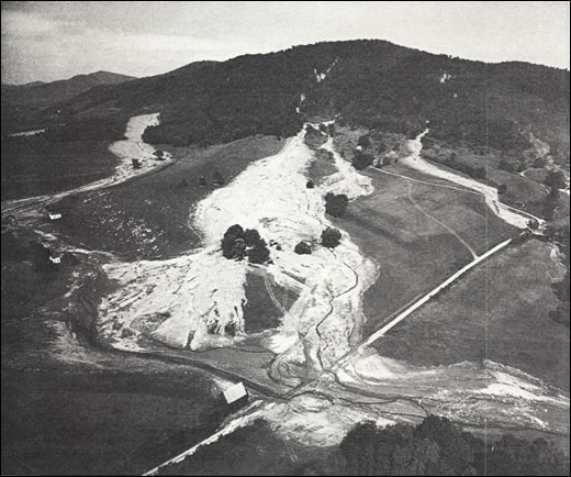
Aerial shot of massive mudflows in the mountains of Nelson County, VA, created by Hurricane Camille’s remnants, Dick Whitehead Collection
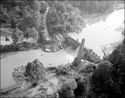
The Schuyler bridge and hydroelectric dam on the Rockfish River were washed out by the hurricane forces. The bridge and power house have washed down river, but the smoke stack remains in place. Located at the intersection of Rt. 617 and Rt. 693 in Nelson County. 8/25/1969. No. 69-2080, Virginia Governor's Negative Collection, Library of Virginia
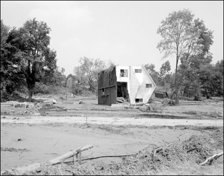
This Nelson County home has been literally turned on its side by the hurricane forces. Located on Rt. 655 at Roseland. 8/26/1969. No. 69-2201, Virginia Governor's Negative Collection, Library of Virginia.
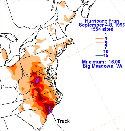
Total rainfall from Hurricane Fran
As a result of this rain, major flooding occurred from the Roanoke River basin northward through the James, Shenandoah and Potomac River basins, including 4 locations in the Shenandoah Basin which recorded all time record river levels.
The hardest hit areas were in Page and Rockingham counties. In Page County, The Virginia Department of Emergency Management reported hundreds of people were rescued with 78 homes destroyed and 417 damaged. In the town of Luray, one home was pushed off its foundation by flood waters from Hawksbill Creek and deposited on the high school football field. Water level rose as high as 2 feet from the top of the field goal upright. In Rockingham County, 40 homes were destroyed and 105 suffered major damage. The state incurred nearly $350 Million in damage with a death toll of 6.
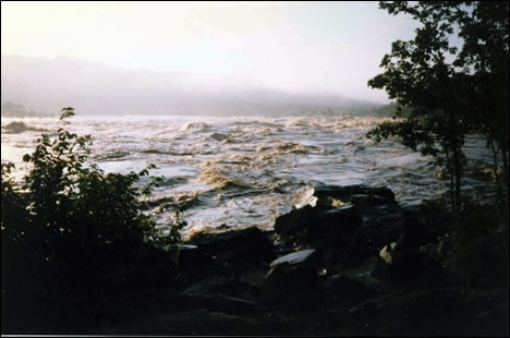
Potomac River at Great Falls State Park (Courtesy National Park Service)
Another view of the Potomac from Great Falls Overlook 3 (Courtesy National Park Service)
 |
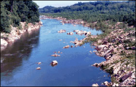 |
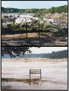
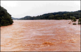
Potomac River at Chain Bridge near Washington, D.C. Looking upstream during flood of September 8, 1996 and during low flow. Images from United States Geological Survey
Learn More:

As a result of these rains, the river levels rose dramatically, with record crest in parts of the New, Roanoke, Chowan and Appomattox River basins. Twelve different gaging locations saw record water levels from this rain. There were 5 deaths reported along with hundreds of thousands of dollars in property damage. Highway damage alone produced damage of nearly $750,000 according to a report from the USGS. The tobacco crop in southern Virginia was largely destroyed by the flood waters.
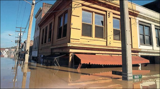
Further to the north in the James River basin, the Scottsville News and Albemarle Current wrote “Flood Warnings out in Scottsville and all along the James from Lynchburg to Richmond. Reports coming in during Thursday as we go to press say the river is rising a foot an hour with a 22 ft. depth expected here in the morning. Merchants in town on Main Street already are under 3 inches of water.” The James River at Scottsville crested at 25.84 ft. on the 16th of August. That water level is currently the 8th highest value seen in Scottsville.
Learn More:
|
||||||