National Weather Service United States Department of Commerce

Active Pattern for the Center of the Nation

Severe thunderstorms, excessive rainfall, critical fire weather are all in the outlook today and into this last weekend of April. Very large hail, severe wind gusts, and a couple strong tornadoes will all be possible across the central and southern Plains today. Flash flooding also possible for portions of the Plains and Mississippi Valley. Critical fire weather conditions for Southern High Plains Read More >

Definitions and Safety Information


The Tornado threat level is based on the probability of being in a Tornado Warning in an area.

The probability of a Tornado Warning in an area is forecast based on :

  • The Probability of Thunderstorms
  • The Probability of a Thunderstorm becoming Severe once it has developed (Conditional Probability)
  • The Probability of a Thunderstorm becoming Tornadic once it has become Severe (Conditional Probability)

Safety - Before, During, and After

Follow lightning and severe thunderstorm safety and preparedness actions as well as the information provided below. The following information is from Roger Edwards (NWS SPC Norman, OK) http://www.spc.noaa.gov/faq/tornado/#Safety


There is no such thing as guaranteed safety inside a tornado. Freak accidents happen; and the most violent tornadoes can level and blow away almost any house and its occupants. Extremely violent F5 tornadoes are very rare, though. Most tornadoes are actually much weaker and can be survived using these safety ideas...

PREVENTION AND PRACTICE
BEFORE THE STORM...

At home, have a family tornado plan in place, based on the kind of dwelling you live in and the safety tips below. Know where you can take shelter in a matter of seconds, and practice a family tornado drill at least once a year. Have a pre-determined place to meet after a disaster. Flying debris is the greatest danger in tornadoes; so store protective coverings (e.g., mattress, sleeping bags, thick blankets, etc) in or next to your shelter space, ready to use on a few seconds' notice.

When a tornado watch is issued, think about the drill and check to make sure all your safety supplies are handy. Turn on local TV, radio or NOAA Weather Radio and stay alert for warnings. Forget about the old notion of opening windows to equalize pressure; the tornado will blast open the windows for you! If you shop frequently at certain stores, learn where there are bathrooms, storage rooms or other interior shelter areas away from windows, and the shortest ways to get there. All administrators of schools, shopping centers, nursing homes, hospitals, sports arenas, stadiums, mobile home communities and offices should have a tornado safety plan in place, with easy-to-read signs posted to direct everyone to a safe, closeby shelter area. Schools and office building managers should regularly run well-coordinated drills. If you are planning to build a house, especially east of the Rockies, consider an underground tornado shelter or an interior "safe room".

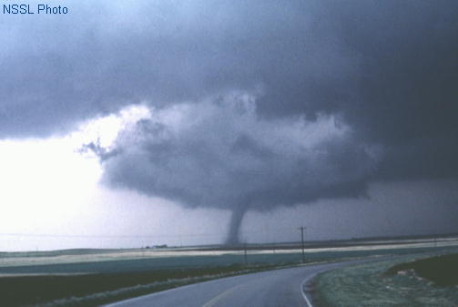
Know the signs of a tornado: Weather forecasting science is not perfect and some tornadoes do occur without a tornado warning. There is no substitute for staying alert to the sky. Besides an obviously visible tornado, here are some things to look and listen for:

  • Strong, persistent rotation in the cloud base.
  • Whirling dust or debris on the ground under a cloud base -- tornadoes sometimes have no funnel!
  • Hail or heavy rain followed by either dead calm or a fast, intense wind shift. Many tornadoes are wrapped in heavy precipitation and can't be seen.
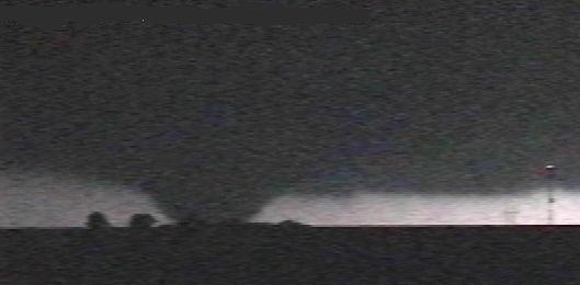
  • Day or night - Loud, continuous roar or rumble, which doesn't fade in a few seconds like thunder.
  • Night - Small, bright, blue-green to white flashes at ground level near a thunderstorm (as opposed to silvery lightning up in the clouds). These mean power lines are being snapped by very strong wind, maybe a tornado.
  • Night - Persistent lowering from the cloud base, illuminated or silhouetted by lightning -- especially if it is on the ground or there is a blue-green-white power flash underneath.


WHAT TO DO IF A TORNADO WARNING IS ISSUED
OR YOU SEE A TORNADO...

In a house with a basement: Avoid windows. Get in the basement and under some kind of sturdy protection (heavy table or work bench), or cover yourself with a mattress or sleeping bag. Know where very heavy objects rest on the floor above (pianos, refrigerators, waterbeds, etc.) and do not go under them. They may fall down through a weakened floor and crush you.

In a house with no basement, a dorm, or an apartment: Avoid windows. Go to the lowest floor, small center room (like a bathroom or closet), under a stairwell, or in an interior hallway with no windows. Crouch as low as possible to the floor, facing down, and cover your head with your hands. A bath tub may offer a shell of partial protection. Even in an interior room, you should cover yourself with some sort of thick padding (mattress, blankets, etc.), to protect against falling debris in case the roof and ceiling failure.

In an office building, hospital, nursing home or skyscraper: Go directly to an enclosed, windowless area in the center of the building -- away from glass and on the lowest floor possible. Then, crouch down and cover your head. Interior stairwells are usually good places to take shelter, and if not crowded, allow you to get to a lower level quickly. Stay off the elevators; you could be trapped in them if the power is lost.

In a mobile home: Get out! Even if your home is tied down, you are probably safer outside, even if the only alternative is to seek shelter out in the open. Most tornadoes can destroy even tied-down mobile homes, and it is best not to play the low odds that yours will make it. If your community has a tornado shelter, go there fast. If there is a sturdy permanent building within easy running distance, seek shelter there. Otherwise, lie flat on low ground away from your home, protecting your head. If possible, use open ground away from trees and cars, which can be blown onto you.

At school: Follow the drill! Go to the interior hall or room in an orderly way as you are told. Crouch low, head down, and protect the back of your head with your arms. Stay away from windows and large open rooms like gyms and auditoriums.

In the open outdoors: If possible, seek shelter in a sturdy building. If not, lie flat and face-down on low ground, protecting the back of your head with your arms. Get as far away from trees and cars as you can; they may be blown onto you in a tornado.

In a shopping mall or large store: Do not panic. Watch for others. Move as quickly as possible to an interior bathroom, storage room or other small enclosed area, away from windows.

In a church or theater: Do not panic. If possible, move quickly but orderly to an interior bathroom or hallway, away from windows. Crouch face-down and protect your head with your arms. If there is no time to do that, get under the seats or pews, protecting your head with your arms or hands.


AFTER THE TORNADO...

Keep your family together and wait for emergency personnel to arrive. Carefully render aid to those who are injured. Stay away from power lines and puddles with wires in them; they may still be carrying electricity! Watch your step to avoid broken glass, nails, and other sharp objects. Stay out of any heavily damaged houses or buildings; they could collapse at any time. Do not use matches or lighters, in case of leaking natural gas pipes or fuel tanks nearby. Remain calm and alert, and listen for information and instructions from emergency crews or local officials.

Other Resources
NWS Severe Weather Information
NWS Tornado/Severe Thunderstorm/Lightning brochure
SPC Tornado FAQ
Red Cross Tornado Preparedness Information
CDC Tornado and Health Information
NWS Tornado Related Fatality Statistics
FEMA Tornado Preparedness Information
FEMA Safe Room Information
 
DSP Threat Definitions
Probability of being in a tornado warning
Nil <2%
Forecast atmospheric conditions are not conducive for tornado development within the forecast area.
Limited 2-10%
Forecast atmospheric conditions are somewhat favorable for tornado development within the forecast area.
Elevated 11-40%
Forecast atmospheric conditions are favorable for tornado development within the forecast area.
Significant 41-80%
Forecast atmospheric conditions are very favorable for tornado development and severe thunderstorms are likely within the forecast area.
Critical >80%
Tornado warnings will be issued in the forecast area.
 
Suggested Actions and Impact Prevention for Emergency Managers
 Check forecasts for updates on thunderstorm potential once or twice during the day.
Monitor the DSP page for updates several times during the day and be aware of the factors limiting tornadic storms such as limited shear, cap, or instability. If storms develop, be ready to activate spotters.
 Spotter activation is likely. Find out the threat timing window for your area. There may be a webinar or web briefing posted on the DSP.
 Spotter activation will be needed. There will be a webinar or briefing available on the web and posted on the DSP.
 All spotters and emergency managers will be needed. Pay close attention to all weather updates. There may be several webinars and web briefings during the day for this critical severe thunderstorm period.


The Severe Thunderstorm threat level is based on the probability of being in a Severe Weather Warning in an area.


The probability of a Severe Weather Warning in an area is forecast based on :

  • The Probability of Thunderstorms
  • The Probability of a Thunderstorm becoming Severe once it has developed (Conditional Probability)
Preparedness - what to do before the storm
  • Become familiar with what a Severe Thunderstorm Watch or Warning means.
  • Know the county in which you live and the names of nearby major cities.
  • Have a NOAA Weather Radio available and check the batteries.
  • Have a plan on what to do when a watch or warning is issued for your area.
  • Prepare a disaster supplies kit and practice your emergency plan.
  • Remove dead or rotting trees and branches that could fall and cause injury or damage during a severe thunderstorm.
  • Think about how to secure outdoor items and protect property from large hail or strong winds. Move cars into garage or under a carport.
  • Consider installing a safe room. Severe thunderstorms can produce strong winds that are equivalent tornadoes wind speeds. Also, tornadoes can form suddenly from severe thunderstorms.
  • Review your homeowner's insurance policy and also prepare/update a list of your home's contents.


  •  
  • Safety - what to do during the storm

  • Move indoors and stay away from windows.
  • If caught outdoors, protect yourself from wind and hail in a low area. Stay away from lightning prone areas such as hills, water, and lone tall trees or power poles.
  • If driving, stop and find shelter if possible. Driving during large hail will increase the damage to your car. Hydroplaning and strong winds will make it dangerous to drive.
  • Look for signs of a developing thunderstorm such as darkening skies, flashes of lightning or increasing wind.
  • Shutter windows and secure outside doors. If shutters are not available, close window blinds, shades, or curtains.
  • If caught in open water, get to land and find shelter immediately.
  • Postpone activities to avoid being caught in a dangerous situation.
Other Resources
NWS Severe Weather Information
NWS Tornado/Severe Thunderstorm/Lightning brochure
FLASH - Thunderstorm Information
FLASH - Hail Information
Red Cross Thunderstorm Preparedness Information
FEMA Thunderstorm Preparedness Information
NWS Wind Related Fatality Statistics
 
DSP Threat Definitions
Probability of being in a severe weather warning
Nil <5%
Forecast Atmospheric conditions are not conducive for severe thunderstorm development within the forecast area.
Limited 5-20%
Forecast Atmospheric conditions are somewhat favorable for severe thunderstorm development within the forecast area.
Elevated 21-40%
Forecast Atmospheric conditions are favorable for severe thunderstorm development within the forecast area.
Significant 41-70%
Forecast Atmospheric conditions are favorable for severe thunderstorm development within the forecast area.
Critical >70%
Severe thunderstorms will develop or move into the area.
 
Suggested Actions and Impact Prevention for Emergency Managers
 Check forecasts for updates on thunderstorm potential once or twice during the day.
 Monitor the DSP page for updates several times during the day and be aware of the factors limiting storms such as limited moisture, cap or lift. If storms develop, be ready to activate spotters.
 Spotter activation is likely. Find out the threat timing window for your area. There may be a webinar or web briefing posted on the DSP.
 Spotter activation will be needed. There will be a webinar or briefing available on the web and posted on the DSP.
 All spotters and emergency managers will be needed. Pay close attention to all weather updates. There may be several webinars and web briefings during the day for this critical severe thunderstorm period.


The Lightning threat level is based on the probability of thunderstorms in an area.


The probability of thunderstorms in an area is forecast based on :

  • Probability of precipitation
  • Availability of instability
Preparedness - what to do before the storm
  • Protect your home/office electronics with surge protectors or other lightning damage protection.
  • Know the county in which you live and the names of nearby major cities.
  • Have a NOAA Weather Radio available and check the batteries.
  • Realize the possibility that outdoor activities may need to be postponed due to the threat of lightning.
  • Look for signs of a developing thunderstorm such as darkening skies, flashes of lightning or increasing wind.
  • Review your homeowner's insurance policy and also prepare/update a list of your home's contents.


  •  
  • Safety - what to do during the storm

  • If thunder roars, move indoors! If you can hear thunder – you are close enough to be struck by lightning! Stay indoors until 30 minutes have passed after you hear the last clap of thunder.
  • Unplug electronic equipment.
  • There is no safe place outdoors. If you are caught outdoors, you can try to lessen your threat of being struck. Stay away from lightning prone areas such as hills, water, golf courses, and lone tall trees or power poles. Do not take shelter in dugouts.
  • Rubber-soled shoes and rubber tires provide NO protection from lightning. However, the steel frame of a hard-topped vehicle provides increased protection if you are not touching metal.
  • Stay away from metal conductors such as wires or fences. Metal does not attract lightning, but lightning can travel long distances through it.
  • If you hear thunder, don’t use a corded phone in any case. Cordless phones and cell phones are safe to use.
  • Keep away from electrical equipment and wiring and also water pipes. Don’t take a bath or a shower or use other plumbing during a thunderstorm.
  • Get out of swimming pools, lakes, rivers, or other bodies of water.
  • If on open water or in a boat, get to land and find shelter immediately.
  • If a person is struck by lightning, call 9-1-1 immediately and if the person is not breathing or is unresponsive, administer CPR . Lightning victims do not carry an electrical charge and are safe to touch.
Other Resources
NWS Lightning Safety
NOAA/NWS Tornado/Severe Thunderstorm/Lightning brochure
FLASH - Lightning Information
Red Cross Thunderstorm Preparedness Information
FEMA Thunderstorm Preparedness Information
NWS Lightning Related Fatality Statistics
 
DSP Threat Definitions
Probability of Thunderstorms
Nil <15%
Atmospheric conditions are not conducive for thunderstorm development within the forecast area.
Limited 15-30%
Atmospheric conditions are somewhat favorable for thunderstorm development within the forecast area.
Elevated 31-60%
Atmospheric conditions are favorable for thunderstorm development within the forecast area.
Significant 61-90%
Atmospheric conditions are very favorable for thunderstorm development and thunderstorms are likely within the forecast area.
Critical >90%
Thunderstorms will occur within the forecast area.


Suggested Actions and Impact Prevention
 Occasionally check forecasts for updates on thunderstorm potential.
 Be prepared to take action if thunderstorms do develop. Remain aware of changing weather conditions and occasionally check forecasts for updates on the thunderstorm activity.
 Be alert to changing weather conditions and be prepared to take action if thunderstorms develop. Frequently check forecasts for updates on the thunderstorm activity.
 Factor thunderstorms into your outdoor plans. Be prepared to move indoors or into shelter when thunderstorms approach.
 Consider postponing outdoor plans due to thunderstorms.


The Heavy Rain threat level is based on the amount of rainfall for an area. This Heavy rainfall assessment is meant to aid in the planning of activities which would be affected by significant rainfall.

Preparedness - what to do before heavy rain occurs
  • Check weather forecasts and consider postponing travel or outdoor activities.
  • Bring in outside possessions that may get washed away during heavy rain.
  • Teach childern about the dangers of playing in or around culverts and ditches during heavy rain.
  • Before it starts to rain, replace old or brittle wipers.
  • When you begin a journey in rain, your shoes will be wet and liable to slip off the pedals. Scuff the soles on the rubber matting or carpeting of the car before you start the engine.
  • All motorists should regularly check that their headlights, tail lights, brake lights, and turn signals are working properly.
  • Check your tires on a regular basis. Bald tires significantly reduce your traction on wet roadways, and offer little resistance to hydroplaning.


  •  
  • Safety - what to do during heavy rain

  • Heavy rainfall may lead to flooding if prolonged or if there is excessive runoff. Excessive runoff can be a result of saturated ground and/or rainfall intensity.
  • Do not play in or around culverts or drainage ditches as swiftly moving water that occurs during heavy rain can sweep you away.
  • Use the two-second rule to maintain a safe distance from the car in front of you and allow an extra two seconds in heavy rain.
  • If it is raining and the roads are wet, slow down. Take your foot off the accelerator and let your speed drop gradually. Never use the brakes suddenly because this may cause the car to skid.
  • Stay toward the middle lanes - water tends to pool in the outside lanes.
  • Turn on your headlights.
  • Be careful of other vehicles to the rear and in blind spot areas as they are especially difficult to see through rain-spattered windows.
  • Be extra careful during the first half hour after rain begins. Grime and oil on the road surface mix with water to make the road slippery.
  • Stay out of areas subject to flooding. Dips, low spots, small creeks, canyons, washes, etc., can become filled with water.
  • If water is over the road, "Turn Around Don't Drown."
  • Urban areas or areas with poor drainage are more susceptible to excessive runoff, which could lead to ponding of water or flooding.
  • Don't follow large trucks or busses too closely. The spray created by their large tires reduces your vision. Take care when passing them as well; if you must pass, do so quickly and safely.
  • Heavy rain can overload the wiper blades. When visibility is so limited that the edges of the road or other vehicles cannot be seen at a safe distance, it is time to pull over and wait for the rain to ease up. It is best to stop at rest areas or other protected areas. If the roadside is your only option, pull off as far as possible, preferably past the end of a guard rail, and wait until the storm passes. Keep your headlights on and turn on emergency flashers to alert other drivers.
Other Resources
Turn Around Don't Drown
NWS Flood and Safety Information
National Road Safety Foundation
SmartMotorist.com
 
DSP Threat Definitions
Average expected rainfall
Nil <0.5 inches
Minimal or no runoff
Limited 0.5-1.5 inches
Limited runoff likely.
Elevated 1.5-2.5 inches
Elevated levels of runoff
Significant 2.5-4.0 inches
Significant runoff
Critical >4.0 inches
Critical amounts of runoff


Suggested Actions and Impact Prevention
 Occasionally check forecasts for updates on thunderstorm potential.
 Runoff is possible. Check gutters and drainage paths.
 Heavy rain and runoff likely. Check drainage paths and consider moving property out of areas that are easily flooded.
 Heavy rain and runoff is expected...may cause flooding. Move property out of low lying or poor drainage areas.
 Heavy rain and critical runoff...likely to cause flooding. Move property out of low lying or poor drainage areas.


The Visibility threat level is based on the forecast or observation of fog (most likely) or smoke and its areal coverage and density. The image depicts the visibility threat level.

Atmospheric conditions that are typical for fog development :

  • Moist ground or moist near ground conditions.
  • Light winds
Preparedness - what to do before low visibility occurs
  • Check your headlights. Add fog lights if needed.
  • If the forecast calls for low visibility, consider postponing your trip until the fog lifts
  • .
  • Be aware that in reduced visibility conditions, drivers tend to follow the tail lights of vehicles in front of them.
  • Aviation interest should monitor forecasts for reduced visibilities at both take-off and landing sites.


  •  
  • Safety - what to do during low visibility
  • Allow extra travel time.
  • Drive with lights on LOW beam. High beams will reflect off the fog, creating a "white wall" effect.
  • Reduce your speed - and watch your speedometer. Fog creates a visual illusion of slow motion when you may actually be speeding.
  • Avoid crossing traffic lanes.
  • Travel with the driver's window partially open. Listen for traffic.
  • If your car is disabled or you can't continue, pull well onto the shoulder and turn off lights. Move away from your vehicle.
  • Consider postponing your trip until the fog lifts.
  • Stay to the right of the roadway.
  • Do not drive into smoke.
  • Boating in reduced visibilities presents two hazards: navigational errors and collisions. Reduce speed and sound fog signals at the time interval specified in the Navigation Rules.
  • When boating, listen for other vessels, the sound of aids to navigation, breaking surf, and other helpful sounds. If your engines are noisy, periodically shift into idle, or even shut them down for a few minutes to listen for faint fog signals.
  • Pilots should follow the appropriate flight rules for thier aircraft and training.
Other Resources
CDC Smoke and Health Information
National Road Safety Foundation
NWS Boat Safety
US Coast Gauard
NWS Aviation Weather Center
 
DSP Threat Definitions
Measure of expected impacts from reduced visibility
Nil = No fog/smoke forecast or observed
Limited = Patchy fog/smoke with visibilities <1/2 mile
Elevated = Patchy Dense fog/smoke with visibilities < 1/4 mile
Significant = Areas Dense fog/smoke with visibilities < 1/4 mile
Critical = Widespread Very Dense fog/smoke with visibilities < 1/10 mile


Suggested Actions and Impact Prevention
 Check forecasts for reduced visibility from fog or smoke.
 Use extra caution near water and low sheltered areas where fog may be denser.
 Be prepared for delays due to traffic slowing down in areas where visibility is less then 1/4 mile.
 Consider delaying driving or give considerable extra travel time due to widespread areas of poor visibility.
 Travel may be very hazardous with visibility approaching zero. Consider postponeing travel until the fog lifts.


The River Flood threat level is based on forecast and observed stages at specific sites on main rivers and also on the amount of rainfall forecast. River Flood Warnings and Statements issued by the WFO and River Flood Outlook information issued by the RFC are used to define the threat levels.

Atmospheric conditions that may lead to river flooding:

  • Heavy rainfall in a short period of time may lead to faster rises and flooding along area rivers.
  • Heavy rainfall over a longer period of time may lead to slower or prolonged rises and flooding along area rivers.
  • Heavy rain upstream may lead to flooding along portions of a river where it did not rain.
Preparedness - what to do before river flooding occurs
  • Become familiar with what a River Flood Watch or Warning means.
  • Know the names of nearby rivers and creeks and know your watershed.
  • Know the county in which you live and the names of nearby major cities.
  • Have a NOAA Weather Radio available and check the batteries.
  • Have a plan on what to do when a watch or warning is issued for your location.
  • If you have property, including livestock, in a flood plain, have a plan to quickly move it if needed.
  • Understand that if roads are flooded, "Turn Around Don't Drown."
  • Identify potential home hazards and know how to secure or protect them before the flood strikes. Be prepared to turn off electrical power when there is standing water, fallen power lines, or before you evacuate. Turn off gas and water supplies before you evacuate. Secure structurally unstable building materials.
  • Learn about your community's emergency plans, warning signals, evacuation routes, and locations of emergency shelters.
  • Prepare a disaster supplies kit and practice your emergency plan.
  • Review your homeowner's insurance policy and also prepare/update a list of your home's contents.


  •  
  • Safety - what to do during river flooding
  • If driving and it appears that the road is flooded or if baracades are securing the road, "Turn Around Don't Drown."
  • Don't wait to move to higher ground if flooding approaches.
  • Move property to higher ground if needed. Bring outdoor possessions, such as lawn furniture, grills and trash cans inside or tie them down securely.
  • Turn off all utilities at the main power switch and close the main gas valve if evacuation appears necessary.
  • Have your immunization records handy or be aware of your last tetanus shot, in case you should receive a puncture wound or a wound becomes contaminated during or after the flood.
  • For a critical threat level, consider filling bathtubs, sinks and plastic soda bottles with clean water. Sanitize the sinks and tubs first by using bleach. Rinse and fill with clean water.
Other Resources
Turn Around Don't Drown
NWS Flood: The Awesome Power brochure
NWS Flood and Safety Information
NOAA Flood Information
CDC Flood and Health Information
Red Cross Flood Preparedness Information
National Flood Insurance Program
FEMA Flood Preparedness Information
FLASH - Flood Information
NWS Flood Related Fatality Statistics
 
DSP Threat Definitions
Category of flooding that is occuring or is expected
Nil = No Flood Warnings or Advisories are in affect and no areas are identified in the flood outlook. Forecast 24 hour rainfall < 2 inches
Limited = No Flood Warnings and no areas identified in the flood outlook. Forecast 24 hour rainfall > 2 inches or Flood Advisories are in affect
Elevated = Minor flooding is forecast or observed or the RFC indicates "possible" moderate or major flooding in the flood outlook.
Significant = Moderate flooding is forecast or observed or the RFC indicates "likely" moderate or major flooding in the flood outlook.
Critical = Major flooding is forecast or observed or the RFC indicates "imminent" moderate or major flooding in the flood outlook.


Suggested Actions and Impact Prevention for Emergency Managers
 Check forecasts and RFC outlooks for updates on river flooding potential once a day.
 Monitor for River Flood watches, warnings, and advisories.
 Refer to the lastest River Flood Warning/Statement for information on the current stage, when the flood will be above flood stage, and how high the river will crest. Barricade roads as neccessary. Agricultural interests in the flood plain may need to move livestock or equipment. Businesses along the river may need to take action to protect propery.
 Refer to the lastest River Flood Warning/Statement for information on the current stage, when the flood will be above flood stage, and how high the river will crest. Roads will like become impassible and barricades may be neccessary. Alert property owners if needed. Prepare for possible evacuations or sheltering if homes are isolated due to high water over the access roads. Agricultural interests in the flood plain will likely need to move livestock or equipment. Businesses along the river may need to take action to protect propery.
 Refer to the lastest River Flood Warning/Statement for information on the current stage, when the flood will be above flood stage, and how high the river will crest. Roads will be inundated and barricades will be neccessary. High water will likey affect homes or businesses and evacuations and/or sheltering will be needed. Be prepared for environmental (toxic substances in the water) and health (water supply/wells affected, pests, water-bourne disease) concerns. Agricultural interests in the flood plain will need to move livestock or equipment. Businesses along the river will likey need to take action to protect propery.


The Flash Flood threat level is based on ground conditions and the amount of rainfall that is forecast. The value used is the probablility of exceeding 3 hour flash flood guidance and is calculated using an expected exponential distribution of rainfall across the area .

Flash Flood guidance contains information on ground conditions and how much rainfall will cause flooding. The amount of rainfall forecast is based on the expected coverage, intensity and duration of Thunderstorms.

Atmospheric conditions that may lead to flash flooding:

  • Heavy rainfall in a short period of time.
  • Heavy rainfall in urban areas or areas with poor drainage.
  • Thunderstorms that redevelop over the same area, causing a prolonged period of rain.
  • Additional rainfall on already saturated ground.
Preparedness - what to do before a flash flood occurs
  • Become familiar with what a Flash Flood Watch or Warning means.
  • Know the county in which you live and the names of nearby major cities.
  • Know nearby rivers and creeks and even what watershed you live in.
  • Have a NOAA Weather Radio available and check the batteries.
  • Have a plan on what to do when a watch or warning is issued for your county or if your city is included in the watch or warning.
  • Understand that if roads are flooded, "Turn Around Don't Drown."
  • Prepare a disaster supplies kit and practice your emergency plan.
  • Review your homeowner's insurance policy and also prepare/update a list of your home's contents.
  • If you live downstream from a dam, become familiar with sirens and community plans in the event of dam failure.


  •  
  • Safety - what to do during a flash flood
  • If driving and it appears that the road is flooded or if baracades are securing the road, "Turn Around Don't Drown." A mere six inches of fast-moving flood water can knock over an adult. It takes only two feet of rushing water to carry away most vehicles, including pickups and SUVs.
  • Be especially cautious at night when it is harder to recognize flood dangers.
  • Road beds may be washed out under flood waters. NEVER drive through flooded roadways. Turn Around Don't Drown.
  • If your vehicle is suddenly caught in rising water, leave it immediately and seek higher ground.
  • Don't wait to move to higher ground if flooding approaches.
  • Do not play in or around culverts, drainage ditches, or other low lying areas. They can quickly fill with fast moving water and sweep a person away.
  • Do not camp or park your vehicle along streams and washes, particularly during threatening conditions.
  • Move property to higher ground if needed.
  • In the event of dam failure, quickly move to higher ground. Follow your family or community action plan.
Other Resources
Turn Around Don't Drown
NWS Flood: The Awesome Power brochure
NWS Flood and Safety Information
NOAA Flood Information
CDC Flood and Health Information
Red Cross Flood Preparedness Information
National Flood Insurance Program
FLASH - Flood Information
FEMA Flood Preparedness Information
NWS Flood Related Fatality Statistics
 
DSP Threat Definitions
Probability of being in a flash flood warning
Nil <5%
Forecast conditions are not conducive for heavy rain and flash flooding.
Limited 5-25%
Forecast conditions are somewhat favorable for heavy rain development and flash flooding.
Elevated 25-60%
Forecast conditions are favorable heavy rain and possible flooding.
Significant 60-80%
Forecast conditions are very favorable heavy rain and possible flooding.
Critical >80%
Widespread Flooding is expected.


Suggested Actions and Impact Prevention
 Occasionally check forecasts for updates on thunderstorm potential.
 Flooding is possible. Be aware of any thunderstorm development and movement.
 Flooding is likely. Closely monitor radar trends and consider moving property out of areas that are easily flooded.
 Flooding is expected. Move property out of low lying or poor drainage areas and be prepared to move to higher ground if needed.
 Widespread flooding is expected. Move to higher ground and if possible get property out of low lying or poor drainage areas.


The Wind Threat level is based on the forecast maximum wind gusts and on watches, warnings, or advisories that are in affect for high wind. This threat level does not include strong winds from thunderstorms.

Preparedness - what to do before high winds occur
  • Remove dead or rotting trees and branches that could fall and cause injury or damage during a high winds.
  • Think about how to secure outdoor items and protect property that may be damaged by high winds.
  • Understand that boating in open waters in high wind is dangerous.
  • Pilots should monitor wind forecasts for both take-off and landing sites. Strong winds can create dangerous flying conditions.
  • Review your homeowner's insurance policy and also prepare/update a list of your home's contents.


  •  
  • Safety - what to do during high winds
  • Secure and protect outdoor items that may blow around in the high wind.
  • If boating, move to protected areas or ashore.
  • Do not drive high profile vehicles such as campers or RVs on days when the threat level is elevated or greater.
  • If the threat level is significant or critical, stay away from windows.
  • Be aware that tree limbs that may have been broken in an earlier thunderstorm or during an ice storm can still be caught up in the trees for an extended period of time. High wind conditions may cause these tree limbs to fall.
Other Resources
NOAA Severe Weather Information
NOAA/NWS Tornado/Severe Thunderstorm/Lightning brochure
NWS Wind Related Fatality Statistics
FLASH - Severe Wind Information
National Road Safety Foundation
 
DSP Threat Definitions
Maximum wind gust (does not include thunderstorm winds)
Nil <25 mph
No Watch, Warning, or Advisory
Limited 25-39 mph
Elevated 40-58 mph
Wind Advisory is in affect for frequent gusts 40-58 mph.
Significant 59-70 mph
High wind warning is in affect for frequent wind gusts > 58 mph
Critical >70 mph
High wind warning for gusts greater than 70 mph.
 
Suggested Actions and Impact Prevention
  Check forecasts for updates on high wind potential.
 Large branches sway. Lightweight items such as empty trash cans blown around - secure lightweight outside items and items you are carrying. Rough waters on lakes - stay closer to shore on lakes.
 Whole trees sway. Medium weight objects such as filled trash cans or lawn furniture are blown around - secure light and medium weight outside items. Large swells on lakes create dangerous boating conditions - boaters stay off of open waters. High profile vehicles impacted - high profile vehicles should avoid routes that are perpendicular to the wind.
 Buildings and trees can be damaged - stay indoors away from windows. All vehicles are impacted. Small boats can capsize. High profile vehicles can be blown off the road. Move vehicles/boats to a sheltered area. Move or secure other outside items.
 Buildings and trees can be damaged - stay indoors away from windows. All vehicles are impacted. Small boats can capsize. High profile vehicles can be blown off the road. Move vehicles/boats to a sheltered area. Move or secure other outside items.


The Air Quality threat level is currently only based on the Ozone Alert issuance by the City of Tulsa. The images shown are forecast concentrations of ground level ozone.

Preparedness - what to do help the air quality
  • Visit here to learn more about air quality and ozone alerts for the Tulsa metro area.
  • Drive less. Try walking, biking, carpooling, or riding the bus. If you leave your car at home one day a week, you could prevent 55 pounds of pollution each year from being emitted into our air. And think of the money you'll save on gas, parking, and car upkeep.
  • Avoid long idle times. Avoid idle times longer than 30 seconds by turning off your car when you're not in traffic.
  • Bring your lunch to work. "Brown-bag-it" or walk to lunch.
  • Trip chain. Combine errands into one trip to minimize "cold starts".
  • Refuel in the evening and don't top off the tank.
  • Do your garden chores gasoline-free. Avoid gas-powered yard tools until evening - or switch to electric-powered tools.
  • Sign up to be an Ozone Alert! Coordinator


  •  
  • Safety - what to do when ground-level ozone is high
  • Leave your car at home. Try different ways of getting to work - like walking, biking, carpooling or riding the bus. Avoid unnecessary trips.
  • Avoid idling. Walk-in rather than drive-thru.
  • Postpone refueling. If you must, do it in the evening.
  • Postpone mowing with gasoline-powered mowers.
  • Postpone errands. Do them another day.
  • Sign up for Email Alert Notifications of Ozone Alert! days.
Other Resources
Tulsa Ozone Alert Information
NWS Air Quality Forecast
NWS Air Quality Awareness
Oklahoma DEQ Air Quality Division
Arkansas DEQ Air Quality Division
EPA Ground-level Ozone Information
EPA Air Quality for Kids
EPA Air Quality Index
CDC Smoke and Health Information
 
DSP Threat Definitions
Ozone affect on air quality
Nil = Good Air Quality
Limited - not used
Elevated = Air Quality Alert is in effect for unhealthy levels of ozone near the ground.
Significant - not used
Critical - not used


Suggested Actions and Impact Prevention
  Check forecasts for updates on air quality and ozone alerts.
 Leave your car at home. Avoid idling. Postpone refueling, errands, and mowing with gasoline powered equipment.


Abbreviation
Weather Term
Probability/Coverage Abbreviation
Probability Coverage Term
T Thunderstorm SChc Slight Chance
T+ Severe Thunderstorm Chc Chance
RW Rain Showers Lkly Likely
A Hail Ocnl Occasional
R Rain Def Definite
L Drizzle Wide Widespread
ZR Freezing Rain Iso Isolated
ZL Freezing Drizzle Sct Scattered
S Snow Num Numerous
SW Snow Showers Brf Brief
IP Ice Pellets Pds Periods
BS Blowing Snow Inter Intermittent
FR Frost Frq Frequent
F Fog Patchy or Areas Patchy or Areas
ZF Freezing Fog Areas Areas of
IF Ice Fog    
H Haze    
K Smoke    
BN Blowing Sand    
BD Blowing Dust    
IC Ice Crystals    
VA Volcanic Ash    
Precipitation Intensity Modifiers
-- Very Light
- Light
m Moderate
+ Heavy
Other Resources
NWS Weather Glossary

American Meteorlogical Society Glossary of Meteorology


The Winter Weather threat level is based on the forecast for snow or ice accumulations.

Atmospheric conditions that may lead to winter weather hazards:

  • Freezing rain - when rain falls and freezes on objects and surfaces that are at or below 32 degrees F. This can lead to black ice (on roads, bridges, overpasses, and sidewalks) and ice accumulations on exposed objects (like trees and powerlines).
  • Snow - snow can create slick spots on roads, even if it is melting. Heavy or blowing snow can greatly reduce visibility. "Thundersnow" generally produces high snowfall rates. Blowing and drifting snow or snow that has become compacted can lead to road hazards.
  • Sleet or Ice Pellets - frozen raindrops that can accumulate on the ground. Sleet will make roads, bridges, overpasses, and sidewalks slick and hazardous. Compacted sleet often behaves like ice.
Preparedness - what to do before a winter storm
  • Prepare for possible isolation in your home by having sufficient heating fuel, bottled water (at least one gallon of water per person per day to last at least 3 days), non-perishable food, and a disaster supplies kit.
  • Winterize your home to extend the life of your fuel supply by insulating walls and attics, caulking and weather-stripping doors and windows, and installing storm windows or covering windows with plastic.
  • Also interize your barn, shed, or any other structure that may provide shelter for your pets, livestock, or equipment.
  • Cut away tree branches that could fall on a house or other structure during a storm.
  • Insulate pipes with insulation or newspapers and plastic and allow faucets to drip a little during cold weather to avoid freezing. Learn how to shut off water valves in case a pipe bursts.
  • Additional risks occur when using alternate heating sources without taking the necessary safety precautions. Be sure to follow the heat source directions carefully, have carbon monoxide detectors nearby, and keep fire extinguishers on hand.
  • Know ahead of time what you should do to help elderly or disabled friends, neighbors or employees.
  • Have your car winterized. Check the antifreeze level. Ensure the battery, brakes, heater, and defroster work properly. Keep you gas tank at least half full. Put on winter tires and/or chains. Keep a winter weather survival kit in your trunk in case you become stranded.
  • Follow the preparedness recommendations for cold temperatures and windchill.


  •  
  • Safety - what to do during a winter storm
  • Listen to your radio, television, or NOAA Weather Radio for weather reports and emergency information.
  • Walk carefully on snowy, icy sidewalks.
  • If you lose power, conserve fuel, if necessary, by keeping your residence cooler than normal. Temporarily close off heat to some rooms.
  • Maintain ventilation when using kerosene heaters to avoid build-up of toxic fumes. Refuel kerosene heaters outside and keep them at least three feet from flammable objects
  • Follow the safety information for cold tempeartures and wind chill and watch for signs of frostbite and hypothermia.
  • Bring pets indoors. If this is not possible, be sure they have proper shelter and an unfrozen water source.
  • Drive only if it is absolutely necessary. If you must drive, consider the following: Travel in the day, don’t travel alone, and keep others informed of your schedule. Stay on main roads.
  • If you become stranded in the car:
    - Turn on hazard lights and tie a brightly colored cloth (preferably red) to the antenna for rescuers to see.
    - Remain in your vehicle where rescuers are most likely to find you. Do not set out on foot unless you can see a building close by where you know you can take shelter.
    - Run the engine and heater about 10 minutes each hour to keep warm. When the engine is running, open a downwind window slightly for ventilation and periodically clear snow from the exhaust pipe.
    - Exercise to maintain body heat, but avoid overexertion. In extreme cold, use road maps, seat covers, and floor mats for insulation. Huddle with passengers and use your coat for a blanket.
    - Take turns sleeping. One person should be awake at all times to look for rescue crews.
    - Drink fluids to avoid dehydration.
    - Turn on the inside light at night when the engine is running so work crews or rescuers can see you.
Other Resources
NWS Winter Weather Information
NWS Winter Weather Preparedness brochure
FEMA Winter Storm Preparedness Information
CDC Winter Weather and Health Information
FLASH - Winter Storm Information
NWS Winter Storm Related Fatality Statistics
Red Cross Winter Storm Preparedness Information
National Road Safety Foundation
 
DSP Threat Definitions
Winter Weather Forecast
Nil = No winter weather forecast
Limited = Light snow is forecast or snowAmt is < 0.10 inch or iceAccum > 0.01 inch
Elevated = Light ice or moderate snow is forecast or snowAmt is < 1 inch or iceAccum > 0.25 inch
Significant = Moderate ice or heavy snow is forecast or snowAmt is < 4 inches or iceAccum > 0.50 inch
Critical = Very heavy ice or snow is forecast or snowAmt is < 8 inches or iceAccum > 1 inch
 
DSP Threat Definitions
Color
Precipitation Type
Grey
Snow
Orange
Sleet
Red
Ice
Purple
Mix
 
DSP Threat Definitions
Snow accumulation
Nil 0 inches
Limited 0.1-1.0 inch
Elevated 1.1-4 inches
Significant 4.1-8.0 inches
Critical >8.0 inches
 
DSP Threat Definitions
Ice accumulation
Nil 0 inches
Limited <0.25 inches
Elevated 0.25-0.50 inches
Significant 0.50-1.0 inches
Critical >1.0 inch


Suggested Actions and Impact Prevention
  Check forecasts for updates on winter weather potential.
 Winter weather, snow, or ice may cause roads to become slick and hazardous, especially on bridges and overpasses. Delay travel if possible. If you must go out, allow extra travel time.
 Roads become snowpacked or ice covered, making travel difficult. Don't travel unless necessary. Some power outages are possible. Prepare for power outages.
 Roads become snow or ice covered and travel may be impossible for most cars. Don't travel unless emergency. Power outages with downed tree limbs and power lines are likely. Prepare for power outages. Move property from under trees.
 Most roads become impassible. Widespread, long-lasting power outages with downed tree limbs and power lines. Prepare for power outages lasting from several days to several weeks. Move property from under trees.


Deteriorating fire weather conditions means that fires of any origin would have increasing potential to spread. Thus the spread index is used to asses the threat of fires burning out of control. This spread index uses a combination of temperature, humidity, wind, and fine fuel state to calculate a value.

The information seen in this graphic is most appropriately used for grass fire potential as the index is based on fuels that can dry within 1 hour (grasses). The fuel state is a seasonal input that is based on whether the grasses in the area are green, dormant and dry, or some state in between. A transition from dormant fuels to green fuels happens quickly in early April. A transition from green to mixed, and then from mixed to dormant happens from the late summer into the early fall.


Preparedness - what to do before the fire danger is high
  • Mow or maintain grass and weeds, especially near roads.
  • Be aware of your area's fire and burning codes and laws.
  • Plant fire resistant vegetation.
  • Have a plan in place in case wildfire threatens your home or workplace or you need to evacuate.
  • Use fire-resistant or noncombustible materials on the roof and exterior structure of your dwelling.
  • Clear a 10-foot area around propane tanks and the barbecue. Place a screen over the grill – use nonflammable material with mesh no coarser than one-quarter inch.
  • Store gasoline, oily rags and other flammable materials in approved safety cans. Place cans in a safe location away from the base of buildings.
  • Review your homeowner's insurance policy and also prepare/update a list of your home's contents.


  •  
  • Safety - what to do during high fire danger
  • Follow State Burning Ban Laws.
  • Monitor any outdoor burning.
  • Avoid throwing cigarette butts onto the ground.
  • When the threat level is elevated, intentional open-burning, including camp fires, should be done with care and with fire control equipment at the ready.
  • When the threat level is significant or critical, open-burning, including camp fires, should be postponed. Fire officials should have staff and equipment ready for a very active grass fire day.
  • Limit your exposure to smoke. Smoke from wildfires is a mixture of gases and fine particles from burning trees and other plant materials. Smoke can hurt your eyes, irritate your respiratory system, and worsen chronic heart and lung diseases.
  • Do not drive into smoke.
Other Resources
NWS Fire Weather Information
CDC Fire and Health Information
FLASH - Wildfire Information
USDA Forest Service - Active Large Fire Incidents
OK-Fire (Weather based decision support products for wildland fire management in Oklahoma)
Red Cross Wildfire Preparedness Information
FEMA Wildfire Preparedness Information
Firewise
 
DSP Threat Definitions
Measure of fire spread conditions. If a wild fire starts due to dry ground conditions and an ignition, then this is a measure of the possible impact of that fire (spreading) due to winds, temperatures and low relative humidities.
Nil <30
(Forestry Impact = Low)
Limited 30-43
(Forestry Impact = High)
Elevated 44-63
(Forestry Impact = Very High)
Significant 64-80
(Forestry Impact = Extreme)
Critical >80
(Forestry Impact = Critical)


Suggested Actions and Impact Prevention
 In general, conditions do not favor rapid or sustained fire spread. Follow any State Burning Ban Laws in affect.
 Some potential exists for fires to spread. Follow State Burning Ban Laws. Care should be taken to monitor any outdoor burning.
 Any fires that start could spread out of control. Follow State Burning Ban Laws. Fire officials should be ready to respond to the spread of accidental fires. Intentional open-burning should be done with care and with fire control equipment at the ready.
 Rapid and sustained fire spread is likely. Follow State Burning Ban Laws. Open-burning should be postponed if possible. Fire officials should have staff and equipment ready for a very active grass fire day.
  Rapid and sustained fire spread is occuring or expected. Follow State Burning Ban Laws. Open-burning should be postponed. Fire officials should have staff and equipment ready for a very active grass fire day.


The Windchill shown is the minimum Windchill for the 24 hour period. Windchill temperature is a measure of the combined cooling effect of wind and temperature. It is based on the rate of heat loss from exposed skin caused by the effects of wind and cold. As the speed of the wind increases, it can carry heat away from your body much more quickly, causing skin temperature to drop. When there are high winds, serious weather-related health problems are more likely, even when temperatures are only cool.

Preparedness - what to do before the wind chill is low
  • The best way to avoid hypothermia and frostbite is to stay warm and dry indoors. Consider postponing outdoor activities.
  • When you must go outside, dress appropriately. Wear several layers of loose-fitting, lightweight, warm clothing. Trapped air between the layers will insulate you. Remove layers to avoid sweating and subsequent chill. Outer garments should be tightly woven, water repellent, and hooded.
  • Infants, small children, and the elderly are more susceptible to cold weather related emergencies like frostbite and hypothermia. Check on elderly neighbors.


  •  
  • Preparedness - what to do before extreme cold occurs

  • Follow the preparedness tips for windchill.
  • Have an emergency supply kit ready in case you lose power.
  • Have a supplimental heat source available. Be sure to follow the directions on using the heat source to avoid carbon monoxide poisoning. Install a smoke detector and a battery-operated carbon monoxide detector near the area to be heated. If you plan to use a fireplace or wood stove for emergency heating, have your chimney or flue inspected each year.
  • Insulate any water lines that run along exterior walls so your water supply will be less likely to freeze. To the extent possible, weatherproof your home by adding weather-stripping, insulation, insulated doors and storm windows, or thermal-pane windows.
  • Prepare your car. Have the radiator system serviced and check the antifreeze level. Replace windshield-wiper fluid with a wintertime mixture. Replace any worn tires, and check the air pressure in the tires. During winter, keep the gas tank near full to help avoid ice in the tank and fuel lines.
  • Keep an emerency kit in your car in case you become stranded.


  •  
  • Safety - what to do when the wind chill or temperature is low
  • Wear a hat because half of your body heat can be lost from your head.
  • Cover your mouth to protect your lungs from extreme cold.
  • Mittens, snug at the wrist, are better than gloves.
  • Try to stay dry and out of the wind.
  • Windchill affects animals too. Bring pets inside. If you cannot bring them inside, provide adequate shelter to keep them warm and make sure that they have access to unfrozen water.
  • Avoid overexertion. Sweating from overexertion could lead to a chill and hypothermia. Cold weather also puts an extra strain on the heart. If you have heart disease or high blood pressure, follow your doctor’s advice about shoveling snow or performing other hard work in the cold. Otherwise, if you have to do heavy outdoor chores, dress warmly and work slowly. Your body is already working hard just to stay warm, so don’t overdo it.
  • Do not drink alcoholic or caffeinated beverages—they cause your body to lose heat more rapidly. Instead, drink warm, sweet beverages or broth to help maintain your body temperature. If you have any dietary restrictions, ask your doctor.
  • Avoid getting gasoline or alcohol on your skin while de-icing and fueling your car or using a snow blower. These materials in contact with the skin greatly increase heat loss from the body.
  • Do not ignore shivering. It’s an important first sign that the body is losing heat. Persistent shivering is a signal to return indoors.
Other Resources
Wind Chill Chart
NWS Wind Chill FAQ
NWS Wind Chill brochure
CDC Extreme Cold and Health Information
FEMA Extreme Cold Preparedness Information
FLASH - Extreme Cold Information
Red Cross Frozen Pipe Preparedness Information
Red Cross Frost Bite and Hypothermia Information
NWS Cold Related Fatality Statistics
 
DSP Threat Definitions
Wind Chill in Degrees F
Nil >= 10 deg F
Limited < 10 deg F
Elevated < 0 deg F or Wind Chill Advisory is in affect
Significant < -5 deg F or Wind Chill Warning is in affect
Critical < -10 deg F
 
Suggested Actions and Impact Prevention
  Check forecasts for updates on the expected wind chill. Be aware that exposure to any temperature or wind chill value below freezing could lead to cold weather health emergencies like frostbite or hypothermia if not dressed appropriately or if wet.
 Extended exposure could cause frostbite. Dress in layers and keep your head covered.
 Prolonged exposure could cause frostbite or hypothermia. Dress in layers and keep your head and fingers covered. Limit your time outside. Use Winter Weather driving preparation.
 Short exposure could cause frostbite or hypothermia. Stay indoors if possible. Delay travel plans if possible.
 Frostbite or hypothermia can happen quickly. Stay indoors and delay travel plans if possible. Call 9-1-1 if you suspect a person is suffering from hypothermia.


The Heat Index shown is the maximum Heat Index for the 24 hour period. The Heat Index combines the temperature with the relative humidity.

Preparedness - what to do before the heat index is high
  • Bring plenty of water.
  • Wear light weight, light fitting, light colored clothes.
  • Consider postponing outdoor activities until a cooler time of day.


  •  
  • Safety - what to do when the heat index is high
  • Slow down. Strenuous activities should be reduced, eliminated, or rescheduled to the coolest time of the day. Individuals at risk should stay in the coolest available place, not necessarily indoors.
  • Put less fuel on your inner fires. Foods (like proteins) that increase metabolic heat production also increase water loss.
  • Drink plenty of water or other non-alcohol fluids. Your body needs water to keep cool. Drink plenty of fluids even if you don’t feel thirsty. Persons who (1) have epilepsy or heart, kidney, or liver disease, (2) are on fluid restrictive diets or (3) have a problem with fluid retention should consult a physician before increasing their consumption of fluids.
  • Do not leave children or pets in the car. Even with the windows cracked open, interior temperatures can rise almost 20 degrees Fahrenheit within the first 10 minutes. Anyone left inside is at risk for serious heat-related illnesses or even death.
  • Do not take salt tablets unless specified by a physician.
  • Spend more time in air-conditioned places. Air conditioning in homes and other buildings markedly reduces danger from the heat. If you cannot afford an air conditioner, spending some time each day (during hot weather) in an air conditioned environment affords some protection.
  • Don’t get too much sun. Sunburn makes the job of heat dissipation that much more difficult.
Other Resources
Heat Index Chart
NWS Heat Wave Information
NWS Heat Related Fatality Statistics
Red Cross Heat Wave Preparedness Information
FLASH - Heat Information
FEMA Heat Preparedness Information
CDC Extreme Heat and Health Information
National Drought Information
Local Drought Information
 
DSP Threat Definitions
Maximum heat index
Nil <100 deg F
Limited 100-105 deg F
Elevated 105-110 deg F or Heat Advisory is in affect
Significant 110-115 deg F or Heat Warning is in affect
Critical >115 deg F and a Heat Warning is in affect


Suggested Actions and Impact Prevention
  Check forecasts for updates on high heat index potential.
 Extended exposure could cause dehydration. Take breaks and drink plenty of water.
 Sunstroke, heat cramps, and heat exhustion possible with prolonged exposure and/or physical activity. Limit your time outside and drink plenty of water.
 Sunstroke, heat cramps or heat ehaustion likely and heatstroke possible with prolonged exposure and/or physical activity in direct sun. Stay in the shade or indoors in air conditioning or a well ventilated room if possible.
 Sunstroke, heat cramps or heat ehaustion likely and heatstroke possible with prolonged exposure and/or physical activity. Stay in the shade or indoors in air conditioning or a well ventilated room.


Special thanks to Dr. Vince Dimiceli (ORU) for help working on this project.
 
The WetBulb Globe Temperature (WBGT) shown is the maximum WBGT for the 24 hour period. Usually it is highest during mid afternoon. The WBGT is a measure of the heat stress in direct sunlight which takes into account; temperature, humidity, wind speed, sun angle and cloud cover (solar radiation). This differs from the heat index which takes into consideration temperature and humidity and is calculated for shady areas. If you work or exercise in direct sunlight, this is a good element to monitor. Military agencies, OSHA and many nations in tropical or hot climate areas use the WBGT as a guide to managing workload in direct sunlight.

Preparedness - What to do before doing outdoor activities when the WBGT is high -
  • Wear a hat and light weight, light fitting, light colored clothes.
  • Plan to take frequent breaks in shady areas.


  •  
  • Safety - What to do while doing outdoor activities when the WBGT is high -
  • Take breaks in the shade. Strenuous outdoor activities should be reduced, especially in direct sunlight where there is little ventilation.
  • Drink plenty of water or other non-alcohol fluids. Your body needs water to keep cool. Drink plenty of fluids even if you don’t feel thirsty.
  • Don’t get too much sun. Sunburn makes the job of heat dissipation that much more difficult
Other Resources

More WBGT Information
WBGT Research Paper
OSHA work load and WBGT Manual

Email local contributors

 
Suggested Actions and Impact Prevention
Level
Affects
Precautionary Actions
green light=no theat    
yellow light=limited threat Working or exercising in direct sunlight will stress your body after 45 minutes. Take at least 15 minutes of breaks each hour if working or exercising in direct sunlight
red light=elevated threat Working or exercising in direct sunlight will stress your body after 30 minutes. Take at least 30 minutes of breaks each hour if working or exercising in direct sunlight
purple light=significant threat Working or exercising in direct sunlight will stress your body after 20 minutes. Take at least 40 minutes of breaks each hour if working or exercising in direct sunlight
black light=critical threat Working or exercising in direct sunlight will stress your body after 15 minutes. Take at least 45 minutes of breaks each hour if working or exercising in direct sunlight