"The National Weather Service (NWS) provides weather, hydrologic, and climate forecasts and warnings for the United States, its territories, adjacent waters and ocean areas, for the protection of life and property and the enhancement of the national economy. NWS data and products form a national information database and infrastructure which can be used by other governmental agencies, the private sector, the public, and the global community."
It is accomplished by providing warnings and forecast of hazardous weather, including thunderstorms, flooding, hurricanes, tornadoes, winter weather, tsunamis, and climate events. The NWS is the sole United States OFFICIAL voice for issuing warnings during life-threatening weather situations.
Every office in the National Weather Service has a County Warning Area (CWA). Our CWA includes all the 19 counties within the center yellow box.

Below is an image of all the County Warning Areas (CWA) in the United States.

Do you wonder what it would be like to work here? Check out our Station Digest.
National Weather Service History
The "Weather Service" in Rapid City have a long history. We have compiled a brief synopsis of events since 1888.

The first Weather Service Office in Rapid City was opened on January 1, 1888. It was located in the Sweeney Building at the corner of 7th and Main Streets. The arrows in the photo point to the weather instruments. The Sweeney Building was destroyed by fire May 8, 1997.

Picture courtesy of Minnilusa Historical Association, Journey Museum, Rapid City
On January 1, 1897 the station was moved to the Lakota Building on the corner of 7th and St. Joseph Streets, one block south of the Sweeney Building. This building is currently known as the Buell Building.

This picture was taken in 1932.
On May 13, 1914 the Weather Office was moved to the former Federal Building on the corner of 8th and St. Joseph.

This was essentially the weather equipment (located on the roof of the Federal Building). At first weather observations were taken only twice daily. Then, beginning in the mid 1930's this was increased to four times daily, and in 1939 it was increased again to hourly around the clock.

This is a picture of the instruments on top of the Federal Building. You can see the wind direction and wind speed system in the foreground. The silver buckets in the background are for rain measurements. The black instrument next to the wind system is unknown.

So that aviation as well as the general public could be served, the first airport station was established on January 19, 1939 at the former airport (now Ellsworth Air Force Base).
From January 1939 until August 1942, personnel were stationed at both the city office and the airport office. In 1942 all activities were consolidated at the airport office.

On October 5, 1950 the Weather Station was moved to the Administration Building at the Municipal Airport, which is about 10 miles east-southeast of Rapid City.

Two times a day the staff at the Weather Station released a weather balloon. While this balloon was in flight various atmospheric measurements were taken.
The piece of equipment in this picture was used to track and plot the balloons flight. The person sitting at the equipment has recently retired from our office. This picture was taken in August, 1963.

The Flood of Rapid City occurred on June 9, 1972. This flood caused extensive damage in Rapid city and the outlying towns. Totals included 238 deaths, 5 missing, 3,087 injured including, 118 hospitalized, 770 permanent homes and 565 mobile homes were destroyed, 2,035 permanent homes and 785 mobile homes were damaged. Total damage throughout the Black Hills was 165 million dollars.
This picture was taken on the corner of East Boulevard North and Omaha street. This was the location of Frontier Ford which is now McKie Ford.

It was estimated that the amount of rain that fell in the flood of 1972 was equivalent to 14.5 Pactola Reservoirs, or 800,000 acre feet. Put in a simpler way 1 million metric tons of water fell in the Black Hills area.
This picture was taken on Chapel Lane where Rapid Creek enters Canyon Lake.

In December 1995 the National Weather Service Office in Rapid City became the proud new owner of a WSR-88D Doppler Radar. This radar greatly enhances our ability to detect and track thunderstorms and other weather phenomena.

In November, 1995 the Upper Air tracking set was moved from the Airport Office to our City Office. This equipment is used to track the weather balloons which are launched twice daily.

In November, 1995 the Weather Station was moved from the Airport Office to its current location. The land was donated to the Weather Service by the South Dakota School of Mines and Technology. All services were consolidated in the City Office on November 11, 1995.

This is the Automated Surface Observing System. This system automatically measures wind speed and direction, rainfall accumulation, visibility, present weather conditions (rain, snow, fog, haze, etc.), and pressure. This information is then automatically transmitted to the National Weather Service main computer systems for dissemination.

In August 1996, the WSR-74C Radar was turned off for the last time. In July 1976, this person turned the WSR-74C on for the first time.
There have been many improvements to our Doppler Radar since 1995. Here, we find one of our Electronics Technicians tuning the radar and a picture of the radar tower.


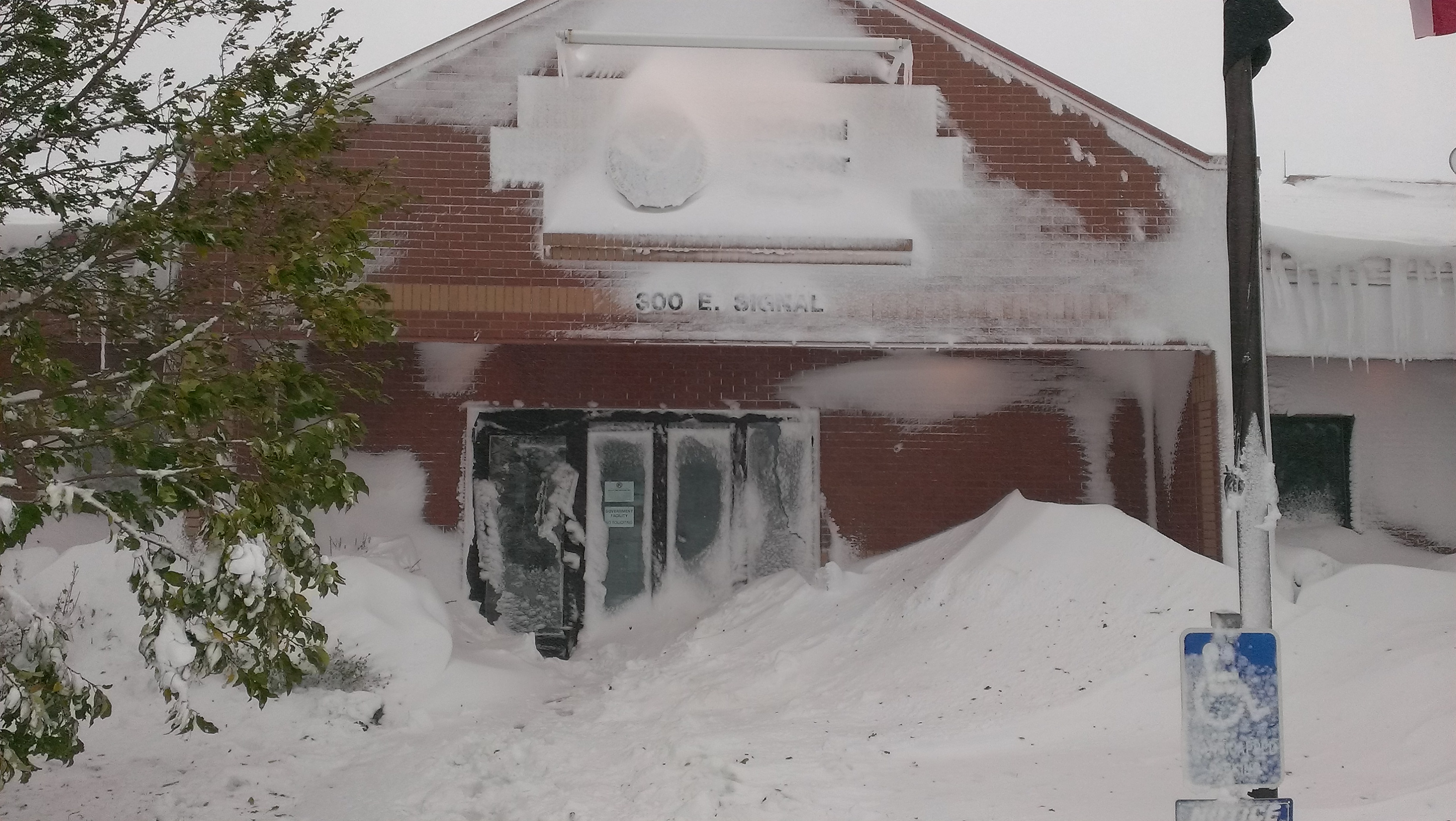
An iconic image of our office on October 4, 2013 during the historic Fall blizzard. Additional information about the blizzard is available.
David Hintz - Meteorologist in Charge - Learn More
Susan Sanders - Warning Coordination Meteorologist
Dr. Matthew Bunkers - Science Operations Officer
Melissa Smith - Service Hydrologist
Alzina Foscato - Observation Program Leader
Robert Baye - Electronics Systems Analyst - Learn More
Kelly Whitaker - Information Technology Officer
Karen Maudlin - Administrative Support Assistant
Kyle Carstens
Jon Chamberlain
Eric Helgeson - Learn More
Jeffrey Johnson - Learn More
Greg Richards
Alex Calderon
Shane Eagan
Katie Pojorlie
Scott Rudge
Dr. Keith Sherburn - Learn More
Stephen Trimarchi
Michael Ford
Nathan Rambo - Learn More


 Follow us on YouTube