National Weather Service United States Department of Commerce

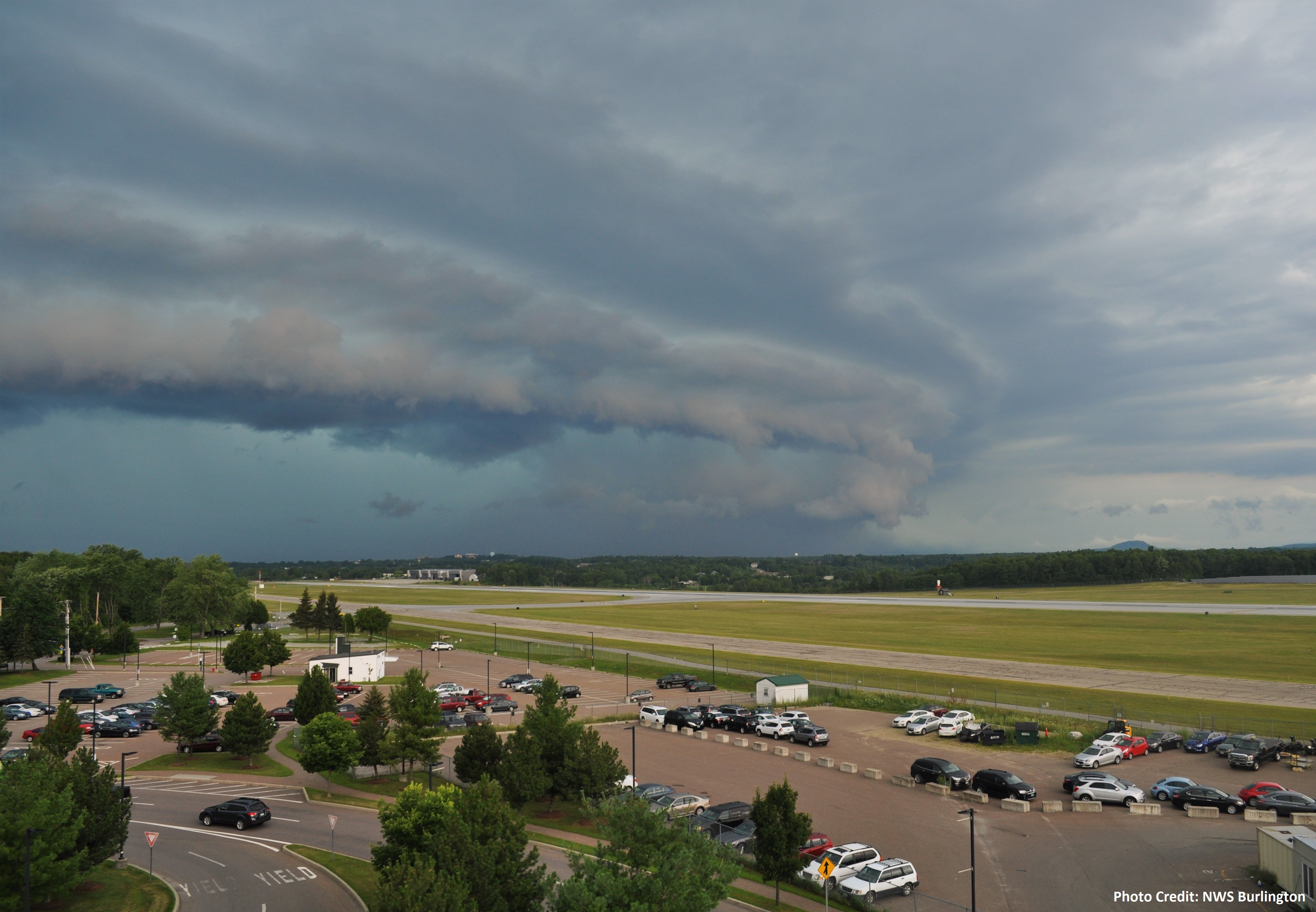
What is SKYWARN®?
            
             The National Weather Service has a wide array of satellite, radar, and automated observation stations used to assess significant weather, but nothing can beat the value of visual confirmation. In the 1960s, SKYWARN® began as an effort to create a network of volunteer weather spotters to provide accurate observations of hazardous weather to the National Weather Service straight away. This aids the forecaster in making informed warning decisions and impact statements that can protect lives within our communities. Your input greatly enhances our capabilities and we thank you for your interest in the SKYWARN® spotter program.

We're happy to announce a new resource for our Skywarn Spotters! An ArcGIS StoryMap Collection about our regional weather is now available for your enjoyment.
 
                       
How to join SKYWARN®
            
There are several ways that you can become a certified SKYWARN® Spotter:
 
  • Complete SKYWARN Spotter Training is available online at COMET/MetEd

  • Attend an on-site SKYWARN® training session: See our SKYWARN® Class Calendar here for events

  • Attend a virtual course: Details will be posted on our SKYWARN® Class Calendar here as they become available.


Please contact us via phone or webmaster to set up any courses, here are the general requirements:
 
  • Have a facility, date and time established, with preferably a back-up date and time.

  • Class sizes are generally offered for at least 15 individuals or for organized outreach events

  • Classes will be offered Monday through Thursday, though if planned well in advance, exceptions may be made for a Friday or Saturday. No sessions will be offered on Sundays

  • Talks are usually held in the evening and last approximately 1.5 to 2 hours, though exceptions can be made if planned in advance

  • Provide a volunteer, or contact point from your group to help in organizing the talk

  • All training is free and open to the public


In-Person Training Events:

 
Date Location Time
March 14th Paul Smiths VIC 6 PM - 8 PM
April 11th Ogdensburg Library, Ogdensburg, NY 6 PM - 8 PM
May 2nd SUNY Potsdam (Kellas Room 106) 6 PM - 8 PM
 

Classes via GoToWebinar Session:

 
Date Registration Time
March 25th https://attendee.gotowebinar.com/rt/2827383593142157655 7 - 8:30 PM EDT
March 31st https://attendee.gotowebinar.com/rt/2827383593142157655 3 PM - 4:30 PM EDT
April 20th https://attendee.gotowebinar.com/rt/2827383593142157655 10 AM - 11:30 AM EDT


* Follow the registration link provided.  


Submitting Reports:  


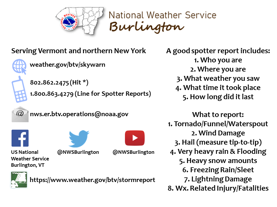
Feel free to use the image above as a print out card [click to enlarge]


Make sure to include when and where in your reports! Include detailed locations, such as crossroads or identifiable landmarks. In addition, photographs of what you witness (e.g. wind damage or hail stones) are always greatly appreciated. These images can be sent to us via social media or our email address listed above.


EVENT TYPE THINGS TO REPORT
TORNADO Observed on the ground or sustained, rotating wall cloud/funnel cloud. Is there a waterspout? What damage has occurred? If safe, can you see where it is headed?
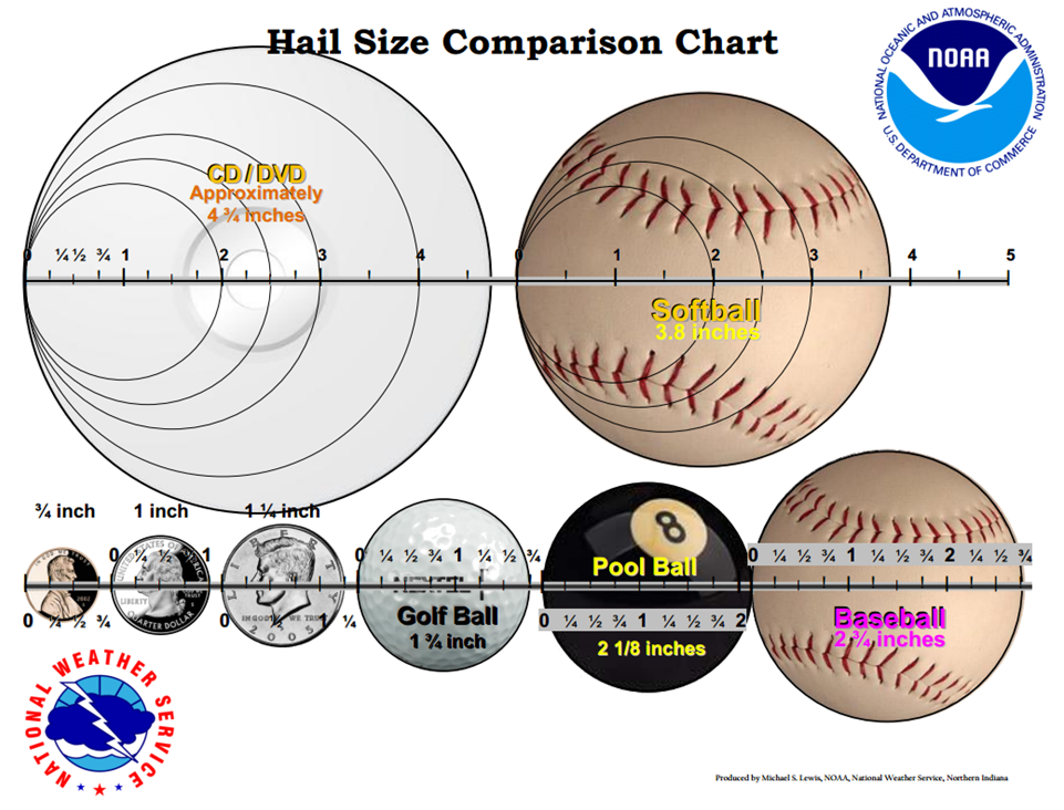
HAIL Measure the largest hailstone or compare to common objects. Quarter size hail is considered severe. For a detailed table click here.
WIND DAMAGE/GUSTS Report downed trees/powerlines or use an instrument to measure. Wind gusts over 58 mph are considered severe.
FLOODING Report flooded roadways, rivers at or over bank full. Is it standing or flowing water? Is it rising or falling? Is there any damage? Is there water in businesses/homes? Is it an ice jam?
HEAVY SNOW Snowfall rates > 1”/hour or a storm total amount. Are there white out conditions?
ICE Report sleet or freezing rain. Check here for how to measure ice accretion. Report hazardous road conditions or damage.
OTHER Unusually frequent lightning or any lightning damage. Changes in precipitation type, especially if not forecasted. Report blowing snow.
Frequently Asked Questions

Do you have questions about the SKYWARN® spotter program? Check out some of these common inquiries. If you have any other unanswered questions, feel free to call us at the National Weather Service in Burlington at 802-862-2475 and hit the * key to chat with a forecaster about the spotter program.

Is there a membership fee?

There is no membership fee, nor is this a club. This is a community effort where you volunteer your time to report adverse weather (or lack thereof) that assists our mission to protect life and property. We encourage organized storm spotter networks, and you can contact your local emergency manager to find out if any are present in your local area.

Do I need an amateur radio license to participate?

Acquiring an amateur radio license is up to you. This is completely optional, and when you receive your spotter certification, you will also receive a hotline number to contact us with reports. If you are licensed, then you can submit reports through ham radio. For additional details and contacts - check here.

What kind of weather should I report?

For common observations when severe weather is occurring, have a look at these detailed tables. Any reports of weather related damages are useful. Whether it is hail, fallen limbs or damaging winds, tornadoes, or flooding, we will gladly receive your reports. A handful of spotters in our network call if little is occurring, and sometimes that is of value too. Reports are not limited to severe/damaging weather, and you can also report snow accumulation and/or depth as well as ice accumulation.

How do I submit a report?

Upon certification, you will receive a 1-800 number that allows you to place direct calls. You can also submit storm reports via social media (Facebook/X) or through the form on our website, here.

How should I report my SKYWARN activity while on vacation?

Check which National Weather Service is responsible for the region that you're vacationing in. Every local National Weather Service Page has their public phone number near the very bottom of their page. When calling in reports to another National Weather Service office outside of your local area, remember to be as specific as possible, using intersections, landmarks, or GPS coordinates. Even if you're not a part of our Spotter network or wherever you are going, we can still mark reports received from Trained Spotters.

What is an on-site, physical SKYWARN® Spotter training class like?

Once a point of contact has been established between us and you, and once a meeting time and place have been established, then we will come over for a 1 to 1.5 hour long class. We will present a lesson on identifying severe weather conditions, how to take accurate snow/ice measurements, and other useful information. Sign up sheets and certificates will be available for anyone interested in joining our spotter network once the training is complete. Check our calendar to see if anything is scheduled! These classes are free of charge.

Are there any restrictions?

This course is recommended for adults due to the complexity and potential dangers of severe weather. Spotter certificates are given to anyone who attends a training session and is at least 16 years of age or older. People younger than 16 who desire a spotter certificate, and who can present special circumstances will be evaluated on a case-by-case basis.

Does my certification ever expire?

Your certification never expires. Courses are available on COMET/MetEd [along with a few recorded sessions] to provide refreshers. Check the Resources tab above for more information.


The following is a list of helpful links to various resources including classes, guides to measuring and reporting severe weather, and other information pamphlets.


  • We're happy to announce a new resource for our Skywarn Spotters! An ArcGIS StoryMap Collection about our regional weather is now available for your enjoyment.


We're happy to announce a new resource for our Skywarn Spotters! An ArcGIS StoryMap Collection about our regional weather is now available for your enjoyment.


Below are slideshows of our most recent warm season and cool season certification presentations. These will be refreshers for you.
This is our latest warm season slide show, and this is our cool season slideshow

Certification will not be assigned based on simply reading or listening to these courses. If you are interested in joining, please reach out, and we will provide instructions.

Below are previous SKYWARN® training sessions available on our local YouTube channel.

Most Recent Recorded Warm Season NWS Burlington SKYWARN® talks

Most Recent Recorded Cold Season NWS Burlington SKYWARN® talks
 
  
Hail Diameter Size Description
1/4" Pea Size
3/4" Penny Size
7/8" Nickel Size
1" Quarter Size
1 1/4" Half Dollar Size
1 1/2" Walnut or Ping Pong Ball Size
1 3/4" Golf Ball Size
2" Hen Egg Size
2 1/2" Tennis Ball Size
2 3/4" Baseball Size
3" Teacup Size
4" Grapefruit/Softball Size
4 1/2" CD/DVD Size

*A convenient downloadable hail comparison graphic can be found here.
 
Wind Speed Estimate Description
25-31 mph Large branches in motion; whistling heard in telephone wires/trees
32-38 mph Whole trees in motion; inconvenience felt walking against the wind
39-54 mph Twigs break off trees; wind generally impedes forward progress while walking
55-72 mph Damage to chimneys and TV antennas; pushes over shallow rooted trees
73-112 mph Peels surfaces off roofs; windows broken; light mobile homes pushed or overturned; moving cars pushed off road
113-157 mph Roofs torn off houses; cars lifted off ground


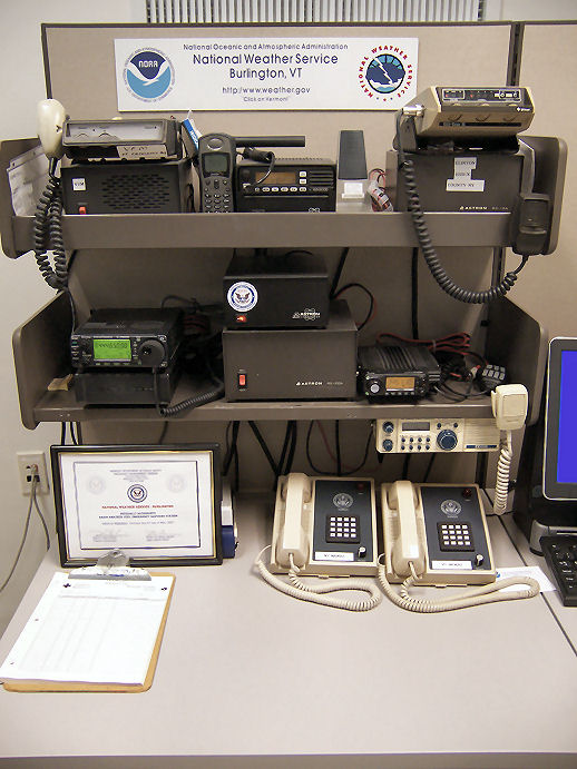
WX1BTV Amateur Radio Station

NWS Burlington has 3 licensed Amateur Radio Operators on staff:

  • KB1QBI, John, Tech
  • KB1QBK, Scott, Tech
  • KC1MYT, Robert, Tech


Monitored Frequencies:

Northern New York: Whiteface Mountain ARES/RACES repeater at 145.110 MHz. Daily weather nets at 7:30 am and 7:00 pm
Vermont: Monkton Repeater at 444.650 MHz, linked repeater system covers much of VT. Monitored as needed during active weather


Equipment:

  • Icom 208H for 2 meter and 440 MHz, Diamond X-50 Antenna
  • Icom 706 for 2 Meter, 440 MHz, and HF bands
    • Carolina Windom HF Horizontal Dipole Antenna
    • Icom AT180 Antenna Tuner
    • Diamond X-50 Antenna (2m, 440 MHz)


WX1BTV is an officially authorized Vermont Emergency Management Radio Amateur Civil Emergency Services (RACES) station. The Icom 706 was chosen to match RACES radio equipment already in place across Vermont. Any Vermont RACES operator deployed to NWS Burlington would already be familiar with its operations. 

Any questions please contact btv.webmaster@noaa.gov


BTV Ham Radio Shack
Mouseover radios for descriptions