| WFO BTV Lake Champlain Forecasts |
| Graphical Lake Forecast | Lake Point Forecasts |
|
 |
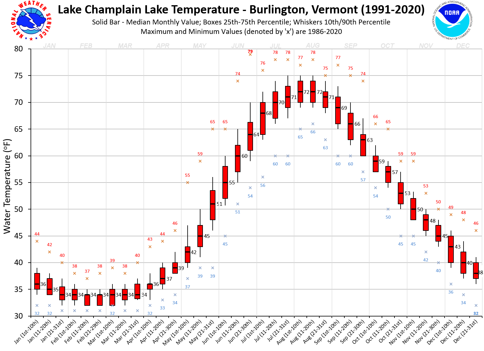
| Current Conditions |
|
|
|||||||||||||||||||||||||||||||||||||||||
USGS Gage at Rouse's Point, NY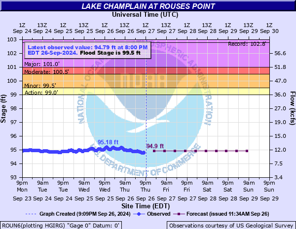 (near real-time) |
USGS Gage at Burlington, VT (near real-time) |
USGS Gage at Port Henry,
NY (near real-time) |
USGS Gage at Whitehall,
NY (near real-time) |
|
Alternate USGS Links |
|
| Lake Champlain Modeled Forecasts |
GLERL
Lake Champlain Nowcast / Forecast System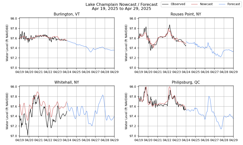 Experimental. Data and products may not always be available and/or accurate. |
Hydrologic
Ensemble Forecasting System Lake Level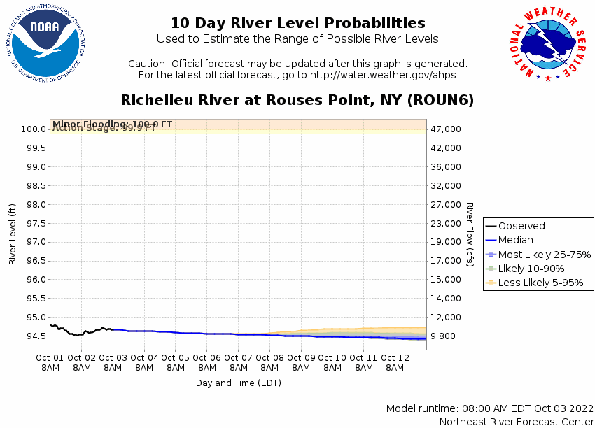 |
| The Science Behind the Creation of the Lake Champlain Forecast |
The National Weather Service in Burlington produces the Lake Champlain recreational forecast from April through December, twice per day at approximately 4 am and 4 pm, with updates made when weather conditions become unrepresentative. Forecasts are valid for either 36 or 48 hours dependent on issuance time, and predict winds, significant wave heights, sensible weather, and associated restrictions to visibility if applicable over the open lake waters. Text, graphical and "point and click" forecasts are available to the user. In addition to these official forecasts, the NWS in Burlington produces a Lake Champlain model forecast which is run 4 times daily. These "model produced" forecasts are created automatically, with no human involvement and predict winds and wave heights only. They have been shown to predict these elements reasonably well under most conditions, and provide an extra source of information to those wanting access to more data. However, having no human involvement should throw caution to the wind and during most situations boaters should refer to the official NWS forecast for the most accurate and representative information. Click here for answers to some frequently asked questions (FAQs) regarding the Lake Champlain Recreational Forecast process.
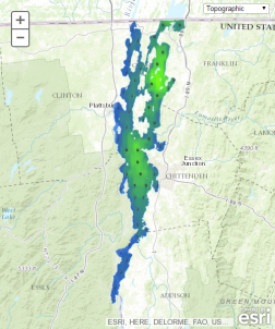
| Lake Champlain Ice Coverage |
During the ice season, typically from December through April, images will be regularly posted on this
page to give winter recreational enthusiasts using the lake a rough idea of ice coverage. The
imagery is 10 meter resolution data from the European Space Agency Sentinel-2 polar orbiting
satellite, which on clear or predominantly sunny days will show approximate ice coverage on the
lake. The times of the images vary, but usually are within an hour or two of local noon when the
satellite passes occur. Please note that ice may be clear or opaque in the pictures with a few
apparently open water areas possibly having a thin, clear cover of ice. Thus this page is intended
as a reference source only, and those planning winter activities on the lake should make use of
additional resources to determine more precise ice coverage and thickness in their area of
interest.
|
|
| Lake Champlain Nautical Charts |
| Other Champlain Information |
| WFO BTV Higher Summits Forecasts |
|
Mountain Point Forecasts
*** Higher summits forecast is valid for 3000 to 5000 foot peaks
*** |
| Mount Mansfield Current Conditions |
Click here for more data |
Regional Mesonet Profile
|
| Mount Mansfield Daily Summary |
| Mount Mansfield Snow Depth |

