Winter 2012-2013 (Northern Ohio, Northwest Pennsylvania)
Winter got off to a late start. There was very little snow until the last week of December, then winter was relatively “normal”. In the end, it was not a bad winter but it stayed too long. There was snow and sleet on Mother's Day, May 12th, in some areas!
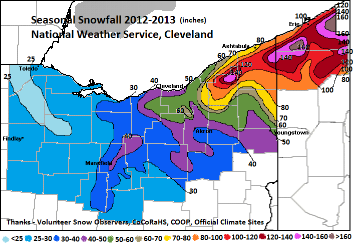
The winter was characterized by a lack of big snows. The largest, widespread snow occurred the day after Christmas with 5 to 10 inches. One lake effect snow event stood out. On January 21st almost 2 feet of snow fell in Erie County, Pennsylvania. The interstates were closed - Mother Nature shut things down for the day. The remainder of the winter featured mostly small to moderate snows. Total snow for the winter was below normal for Northwest Ohio (Toledo 22.4 inches vs 37.6 normal), near normal across northeast Ohio (Akron/Canton 47.2 vs 47.5) and above normal for extreme eastern Ohio and northwest Pennsylvania (Erie 105.5 vs 100.9).
Winter temperatures averaged a little above normal. Most of the warmth occurred during the first 3 weeks of December and in two warm surges in January (the 13th and 30th). The coldest low temperature for most was near zero - many locations had no sub-zero temperatures. February and March were below normal in temperature - good for producing maple syrup but not so good for those waiting for Spring (Cleveland monthly temps vs normal Nov2012 -3.6F, Dec2012 +5.4, Jan2013 +2.3, Feb2013 -2.6, Mar2013 -4.6, Apr2013 -0.9).
| 2012-2013 | Oct 12 | Nov 12 | Dec 12 | Jan 13 | Feb 13 | Mar 13 | Apr 13 | May 13 | Total 2012-13 |
| Toledo | T | T | 7.0 | 3.1 | 10.6 | 1.4 | 0.3 | 0 | 22.4 |
| Mansfield | 2.5 | 0.1 | 10.2 | 5.4 | 11.6 | 9.5 | 0.1 | 0 | 39.4 |
| Cleveland | 0 | 0.3 | 15.2 | 5.4 | 19.8 | 10.7 | 0.3 | 0 | 51.7 |
| Akron-Canton | T | 0.5 | 13.8 | 10.9 | 11.2 | 10.5 | 0.3 | 0 | 47.2 |
| Youngstown | 0 | 2.9 | 24.3 | 12.9 | 20.3 | 19.9 | 0.6 | T | 80.9 |
| Erie PA | 0 | 3.1 | 20.4 | 29.0 | 26.8 | 25.4 | 1.0 | 0 | 105.7 |

