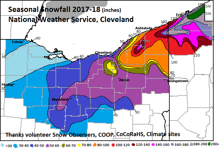
When we look back at the winter of 2017-'18 in northern Ohio and northwest Pennsylvania, two things will stand out: the record amount of snow near Erie, PA and that winter hung on to the bitter end through April.
We consider meteorological winter to be December through February. Temperatures were cold (well below normal) for a relatively short part of the winter, from Christmas day through mid-January. During this time, readings dropped below zero in many areas. February turned warm. Remember the 70 degree day on February 20th? Overall, temperatures for the winter were a tad above normal. Of course it got cold again in March and stayed cold through April. This would be meteorological spring (March-May). The March-April stretch will go down as one of the coldest ever.
Snow was light to moderate much of the winter. Aside from a few lake effect events (and one really big lake effect snow), there were no large snow storms. A couple of systems brushed the counties south of the Turnpike with 4-6 inch storms, mainly from Akron to Canton and Youngstown. The duration of the snowy weather (into April) ended up bringing seasonal snow to near normal levels with above normal amounts from Akron to Youngstown and in the snowbelt. Of course, the granddaddy snow storm occurred at Erie, PA. Starting on Christmas day, it snowed for about 60 hours and it added up to about 50 inches. Remarkable!
A State Climate Extremes Committee (SCEC) convened to validate the record snowfall totals. Here is a link to the press release for the event: www.weather.gov/cle/news_ErieSnowfall_Records_Report and here is the link to the event webpage: www.weather.gov/cle/event_20171225-20171227_Erie_Snow
| 2017-2018 | Oct 17 | Nov 17 | Dec 17 | Jan 18 | Feb 18 | Mar 18 | Apr 18 | May 18 | Total 2017-18 |
| Toledo | 0 | T | 13.9 | 6.6 | 10.3 | 1.9 | 1.6 | 0 | 34.3 |
| Mansfield | 0 | 0.1 | 13 | 8.8 | 8.1 | 11.1 | 5.2 | 0 | 46.3 |
| Cleveland | 0 | 0.8 | 17.2 | 12 | 7.1 | 12.7 | 3.3 | 0 | 53.1 |
| Akron-Canton | 0 | 0.1 | 14.0 | 12.2 | 11.9 | 8.9 | 6.2 | 0 | 53.3 |
| Youngstown | T | 1.0 | 19.0 | 23.1 | 15.0 | 15.6 | 7.6 | 0 | 81.3 |
| Erie PA | 0 | 0.5 | 93.8 | 22.4 | 12.7 | 30.9 | 6.0 | 0 | 166.3 |
Snow Samples (Volunteer observations):
Toledo 2.2 WSW 30.7
Perrysburg 1.6 WSW 29.5
Waterville 2.4 NNE 26.0
Bowling Green 1.7 WNW 26.2
Findlay 30.5
Put-In-Bay 17.6
Port Clinton 2.5 W 20.4
Sandusky 24.7
Fremont 2.2 ENE 27.0
Tiffin 5.2 SE 33.1
Upper Sandusky 28.3
McCutchenville 4 NE (Seneca Cty) 31.6
Huron 29.0
Castalia 1.8 NNE 35.2
Bellevue 47.6
New London 3 NW (IHuron Cty) 56.5
Bucyrus 33.5
Mt Gilead 4.9 ESE 41.9
Galion 1.1 W 51.2
Lorain 3 S 48.4
Elyria 49.0
Wellington 5.5 SW 48.6
Lodi 62.6
Sullivan (Ashland Cty) 53.9
Kidron 33.2
Mansfield (City) 41.4
Lexington (Richland Cty) 44.9
Westlake 44.9
Cleveland Old Brooklyn 56.3
Strongsville 1.3 SE 59.6
Parma 1.9 NNW 61.5
Parma 1.8 SE 75.0
Maple Heights (Cuyahoga Cty) 80.0
Shaker Heights 77.0
Bedford Heights 81.2
Chagrin Falls 100.2
Brunswick 66.4
Wadsworth 4.7 WNW 55.6
Chippewa Twp 55.7
Dalton 56.9
Sagamore Hills 84.4
Streetsboro 2.1 SSW 61.1
Mantua 88.5
Hiram 79.3
Kent 3.6 W 59.2
Ravenna 52.4
Cuyahoga Falls 52.8
Munroe Falls 63.5
Fairlawn 58.3
Akron 55.0
Greene (Summit Cty) 59.4
East Canton 43.1
Alliance 51.5
Waynesburg (Startk Cty) 43.1
Magnolia (Stark Cty) 51.4
Willoughby 2.9 SW 61.7
Kirtland 70.6
Mentor 66.1
Geneva 99.0
Madison 4.2 S 124.1
Montville 132.8
Hambden Twp (Geauga Cty) 149.2
Chardon (water plant) 130.6
Burton 110.4
Middlefield 92.5
Ashtabula 107.8
North Kingsville 133.7
Kellogsville (Ashtabula Cty) 111.6
Conneaut 115.3
Monroe Twp (Ashtabula Cty) 192.7
Pierpont 2 SE 141.1
Jefferson 119.0
Orwell 84.3
Warren 53.1
Canfield 59.3
Austintown 52.5
Salem 4.5 NE 57.8
Erie 5 SE, PA 212.8
McKean 4 SE PA, 157.8
North East 6 SW PA, 230.0
Colt Station, PA (Erie Cty) 227.6
Wattsburg, PA 142.1
Amity Twp, PA (Erie Cty) 138.3
Edinboro, PA 156.4
Conneaut Lake, PA 93.3
Canadohta Lake 143.0
Drakes Mills 196.8
Meadville 5 W, PA 145.0

