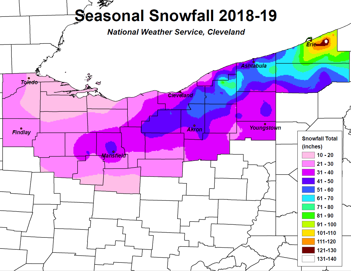
The winter of 2018-2019 in northern Ohio entered quickly as a potent lake effect snow event impacted the snow belt region the second weekend of November. A quick transition from rain to snow allowed for portions of Ashtabula County to get up to two feet of snow in just several hours on a sleepy Saturday morning on November 10. Snow became less frequent for the remainder of the month, but temperatures stayed cool throughout the month and November 2018 was one of the cooler Novembers on record. Once the calendar flipped to December, temperatures transitioned to be well above normal for the month and December 2018 was one of the warmest Decembers on record. Several minor snow events occurred during this month, but altogether snow totals remained below 12 inches across the entire area for the month with most receiving just a paltry couple of inches. The end of the month was warm with high temperatures in the 50s and 60s for the holidays and crossing into 2019.
January 2019 was the most active winter month for the 2018-2019 season in northern Ohio. A fairly robust multi-banded lake effect snow event on January 9-11 impacted the primary and secondary snow belts of Northeast Ohio, when many locations received 8 to 12 inches of snow. This was also the first impactful snowfall of the season for the Cleveland metro area. The most significant snowfall of the season for our entire forecast area occurred just a week and a half later over Martin Luther King Jr. weekend. A widespread snow storm hit northern Ohio with 8 to 18 inches of snow in a 24 hour period. The heaviest snow was located along Interstate 71 from Mansfield to Cleveland and then east through the Northeast Ohio Snow Belt. Some freezing rain and sleet mixed in with the snow over portions of central Ohio, allowing for additional impacts but lesser snow amounts. This event was the first significant widespread snowfall across the entire northern half of Ohio since February 2015. Late January featured a deep arctic freeze as temperatures plummeted to well below zero on January 30 and 31. Some locations were below zero for almost 24 hours! Record lows were set in Mansfield and Toledo. Strong winds over the region allowed for frigid wind chills of -25 to -40 degrees Fahrenheit, which closed schools for the two days.
The 2019 winter season ended with some February ice and a cool March. February had several minor snow events and slightly above normal temperatures. However, there were several freezing rain events during the month. One freezing rain event in the Toledo area on February 12 coated the metro area in a quarter to half an inch of ice, shutting down the city. Winter lingered into March with a couple minor snow events and below normal temperatures, but impacts were minimal to the region. In summary, winter 2018-2019 featured above normal temperatures and below normal snowfall for all areas with notable events that occurred in January with a good widespread snow storm and arctic cold snap.
|
2018-2019 |
Oct 18 |
Nov 18 |
Dec 18 |
Jan 19 |
Feb 19 |
Mar 19 |
Apr 19 |
May 19 |
Total 2018-19 |
| Toledo (TOL) | 0 | 3.7 | 0.1 | 13.1 | 4.9 | 3.8 | 0 | 0 | 25.6 |
| Mansfield (MFD) | T | 5.0 | 1.6 | 25.2 | 10.7 | 4.0 | 0.2 | 0 | 46.7 |
| Cleveland (CLE) | 0 | 4.4 | 2.8 | 16.0 | 5.4 | 6.6 | T | 0 | 35.2 |
| Akron-Canton (CAK) | 0 | 5.7 | 2.3 | 19.7 | 9.4 | 4.7 | T | 0 | 41.8 |
| Youngstown (YNG) | T | 8.1 | 3.7 | 21.8 | 5.7 | 6.0 | 0.3 | 0 | 45.6 |
| Erie, PA (ERI) | 0 | 19.5 | 6.4 | 47.0 | 12.3 | 5.1 | T | 0 | 90.3 |
Listing of Snow Totals by Official NWS CO-OP Observers:
| City | Snow Total |
| Findlay | 23.3 |
| Elmore | 13.9 |
| Fremont | 15.6 |
| Galion | 25.1 |
| Bucyrus | 31.3 |
| Centerburg | 10.2 |
| Greer | 21.5 |
| Millersburg | 27.6 |
| Mansfield | 37.5 |
| Norwalk | 18.4 |
| Oberlin | 26.6 |
| Wooster | 29.7 |
| Munroe Falls | 48.8 |
| Mosquito Creek Lake | 32.6 |
| Berlin Dam | 29.4 |
| Ravenna | 37.9 |
| Chardon | 68.7 |
| Springboro, PA | 64.1 |
| Union City, PA | 82.4 |
| Titusville, PA | 55.3 |
| Jamestown, PA | 30.9 |
Listing of Selected Snow Totals by NWS Cleveland Snow Spotters:
| Location | Snow Total |
| Greenfield Township, PA | 140.0 |
| Greene Township, PA | 122.7 |
| North East Township, PA | 115.5 |
| Colt Station, PA | 107.4 |
| Edinboro, PA | 93.2 |
| North East, PA | 91.8 |
| Amity Township, PA | 90.4 |
| Hambden Township, OH | 87.6 |
| Harborcreek, PA | 82.9 |
| Montville, OH | 77.6 |
| Union City, PA | 75.5 |
| Pierpont, OH | 75.0 |
| Harpersfield Township, OH | 71.1 |
| Monroe Township, OH | 71.1 |
| Lake City, PA | 68.0 |
| Ashtabula - Edgewood, OH | 64.2 |
| Girard, PA | 63.2 |
| Kelloggsville, OH | 63.0 |
| Meadville, PA | 62.7 |
| Middlefield, OH | 62.7 |
| Thompson Township, OH | 59.5 |
| Sagamore Hills, OH | 56.4 |
| Cherry Valley Township, OH | 53.5 |
| Lyndhurst, OH | 53.2 |
| Chagrin Falls, OH | 52.2 |
| Burton, OH | 51.9 |
| Hiram, OH | 51.4 |
| Brunswick, OH | 50.4 |
| Medina, OH | 48.9 |
| Newton Falls, OH | 46.6 |
| Tallmadge, OH | 46.0 |
| Bath Township, OH | 46.0 |
| Townville, PA | 45.8 |
| Mansfield, OH | 45.7 |
| Homerville, OH | 45.4 |
| Ashtabula, OH | 44.3 |
| Lodi, OH | 44.3 |
| Shaker Heights, OH | 44.0 |
| Geneva, OH | 43.0 |
| Concord Township, OH | 42.8 |
| Galion, OH | 42.7 |
| South Madison, OH | 42.2 |
| Conneaut, OH | 41.6 |
| Orwell, OH | 39.8 |
| Andover, OH | 39.6 |
| Alliance, OH | 38.5 |
| Madison, OH | 38.5 |
| Cortland, OH | 37.3 |
| Magnolia, OH | 36.4 |
| Waynesburg, OH | 36.4 |
| Strongsville, OH | 36.0 |
| Kirtland, OH | 34.9 |
| Cleveland-Old Brooklyn, OH | 34.6 |
| Elyria, OH | 33.9 |
| Jackson Township (Stark), OH | 32.6 |
| Massillon, OH | 32.3 |
| Poland, OH | 32.3 |
| New Franklin, OH | 32.1 |
| Cleveland Heights, OH | 32.1 |
| East Canton, OH | 32.0 |
| North Ridgeville, OH | 32.0 |
| Canfield, OH | 31.9 |
| Warren, OH | 31.3 |
| Mansfield 7 NE, OH | 31.0 |
| Austintown, OH | 30.5 |
| Euclid, OH | 28.8 |
| Mentor, OH | 28.8 |
| Marion, OH | 22.8 |
| Upper Sandusky, OH | 21.4 |
| Sylvania, OH | 21.1 |
| Sheffield Lake, OH | 20.1 |
| Bowling Green, OH | 19.6 |
| Huron, OH | 18.5 |
| Sandusky, OH | 16.0 |

