Hurricane Sandy tracked up the east coast of the United States and merged with an upper level trough on October 29, 2012. Hurricane Sandy transitioned to a post-tropical cyclone and came onshore around 8 pm EDT in Southern New Jersey with an impressive central pressure of 946 mb or 27.94 inches. The post-tropical cyclone tracked west across Pennsylvania overnight on October 29 and brought damaging winds and prolonged rainfall to Northern Ohio.
The Visible Infrared Imaging Radiometer Suite (VIIRS) on the Suomi NPP satellite acquired this image of the storm around 3:35 am EDT on Oct 30th. (Imagery Credit: NASA Earth Observatory)

Impacts from High Winds-------------- On Land --------------
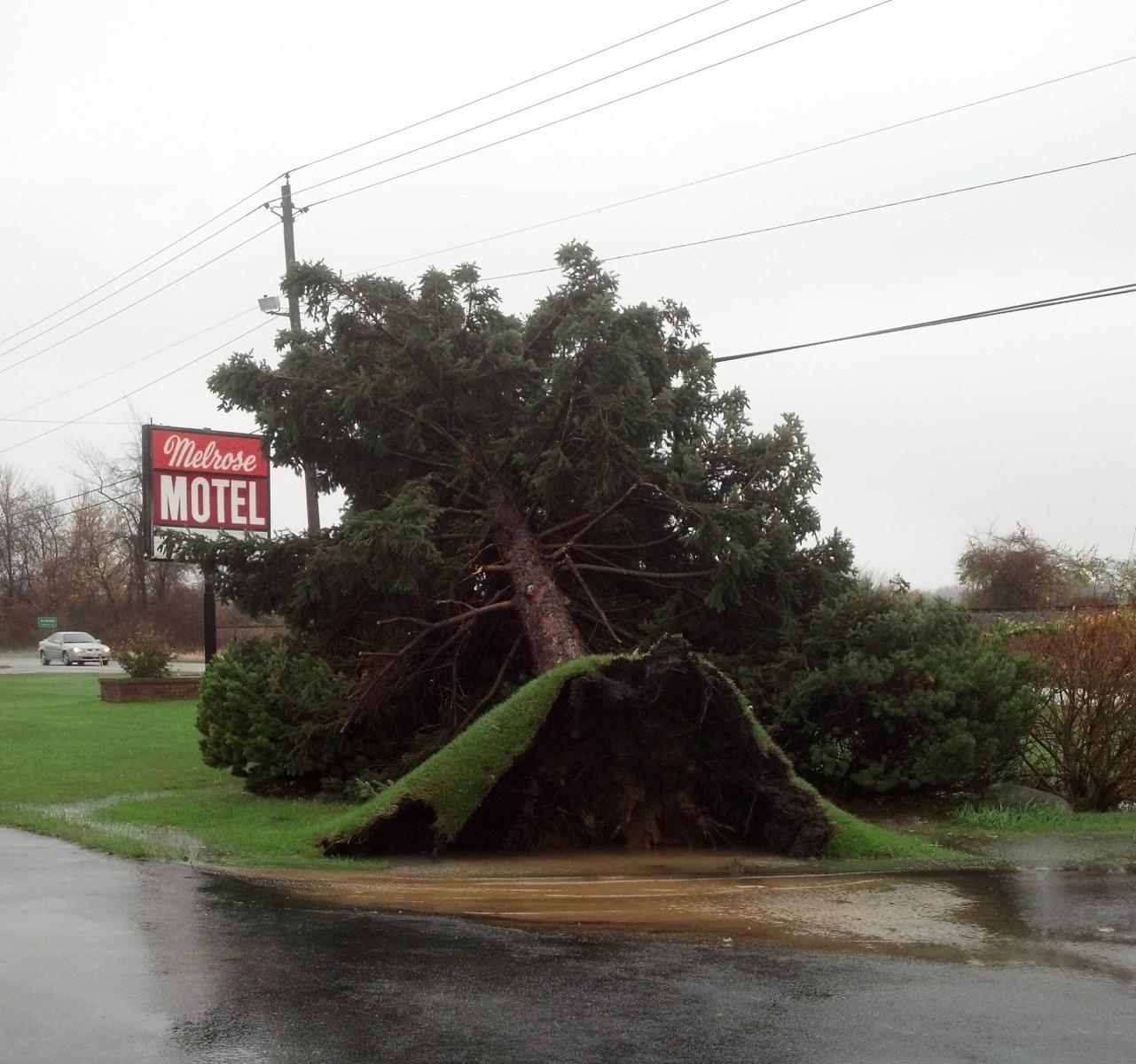
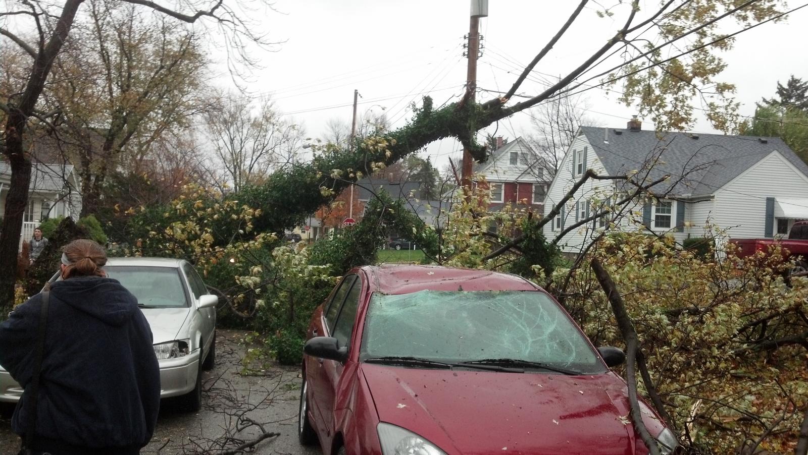
Northerly winds were especially strong downwind of Lake Erie due to the un-obstructed flow and deeper mixing heights over the warm water. High winds impacted the lakeshore counties of northern Ohio. The strong winds caused extensive tree damage with widespread power outages and even structural damage to some buildings. The Cleveland metro area was particularly hard hit with numerous school closures (some for multiple days).
* Burke Lakefront Airport was without power for a time during the night and the peak wind may not have been recorded.
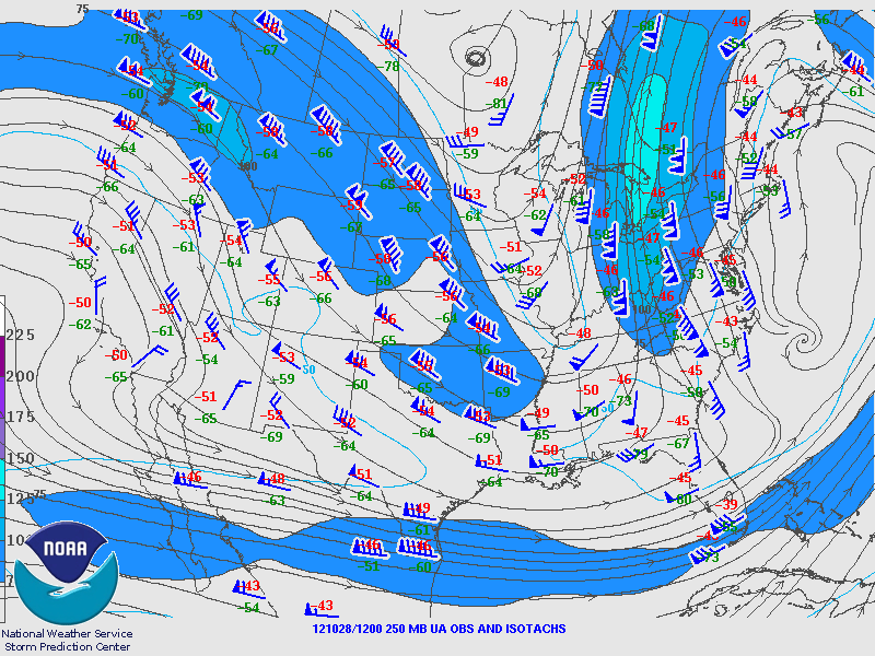
The above surface analysis with radar and satellite over-layed shows the storm at 11 PM EDT on Monday night shortly after the low center moved ashore. The yellow contours are lines of equal pressure. The tighter packed the lines are the windier it is. -------------- Over Water --------------
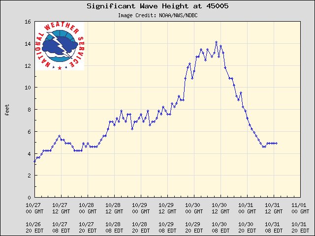
Buoy 45005 Lake Erie
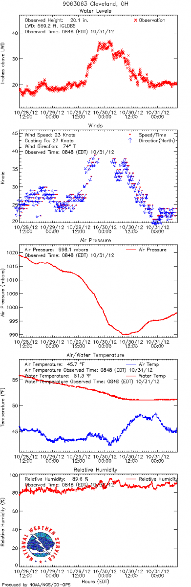
Storm Force winds (50 knots) generated waves of 15 to 18 feet. Waves reached as high as 14 feet from buoy 45005 located 16 NM northwest of Lorain (shown in the graph above). Below are charts from (National Ocean Service) equipment at Cleveland that records water level and various meteorological data. The water level was nearly 3 feet above low water datum (a nautical reference mark). This was 1 to 2 feet above recent levels. Before and after the storm readings were just under 20 inches.
|
|||||||||||||||||||||||||||||||||||||||||||||||||||||||||||
|---|---|---|---|---|---|---|---|---|---|---|---|---|---|---|---|---|---|---|---|---|---|---|---|---|---|---|---|---|---|---|---|---|---|---|---|---|---|---|---|---|---|---|---|---|---|---|---|---|---|---|---|---|---|---|---|---|---|---|---|
Impacts from Rain
Prior to the arrival of Hurricane Sandy to the east coast, a continental (mid-latitude) weather system was making its way across the Midwest and Great Lakes. This brought rainfall to the local area on Friday night (10/27) and Saturday morning (10/28). Rainfall amounts ranged from 0.5 inches to 1.5 inches as shown by the images below of rainfall reports from our Cooperative Weather Observers.
This system interacted with and absorbed the tropical system, Sandy, moving north just offshore of the east coast. By the time Sandy made landfall in NJ, it had lost its tropical characteristics and was considered post-tropical (or extra-tropical).
The cold front that had crossed the area on Friday night stalled just to our east and was re-invigorated by the developing hybrid storm. Additional rain fell Sunday and Sunday night (1.0"-1.5"). By Monday the precipitation shield from the merged system reached as far west as western Ohio.
Rainfall from Monday and Monday night (8 AM EDT Mon - 8 AM EDT Tues): rainfall from this 24-hr period ranged from under a half inch in northwest OH to 1.5 to 3.5 inches across north central Ohio into northwest PA. On the outskirts of the precipitation shield late Monday night into Tuesday, snow fell from Findlay to Mansfield and Columbus. The Mansfield Airport reported 2.5 inches of snow. The rainfall led to flooding along area rivers. The Cuyahoga River reached into major flood status. The Huron, Vermilion, Chagrin, and Black Rivers reached into minor and moderate flood status. Along the Cuyahoga River the worst flooding occurred in the Valley View area where many roads were blocked and basements inundated. With the winds forcing large waves on Lake Erie and a rise in water level along the southern shore, rivers were not draining as efficiently. The combination of lake-induced flooding and river flooding from rainfall resulted in flooding in the towns of Willoughby and Vermilion, where homes near the mouth of the rivers were inundated.
Rain continued the remainder of the week as the influence of the low lingered. The center of the low reached western PA late Tuesday and then began to slowly pull away Wednesday onward. Precipitation is locally enhanced by Lake Erie and from upslope flow across the higher terrain of northeast Ohio. |
||||||||||||||||||||||||||||||||||||||||||||||||||||||||||||||||||||||
|---|---|---|---|---|---|---|---|---|---|---|---|---|---|---|---|---|---|---|---|---|---|---|---|---|---|---|---|---|---|---|---|---|---|---|---|---|---|---|---|---|---|---|---|---|---|---|---|---|---|---|---|---|---|---|---|---|---|---|---|---|---|---|---|---|---|---|---|---|---|---|
Preliminary Local Storm Report
|
|---|
0100 PM NON-TSTM WND DMG PORT CLINTON 41.51N 82.94W
10/29/2012 OTTAWA OH BROADCAST MEDIA
HOLIDAY INN SIGN BLOWN OVER.
0250 PM NON-TSTM WND DMG AMHERST 41.40N 82.23W
10/29/2012 LORAIN OH PUBLIC
30 FOOT TREE DOWN ACROSS ROAD DAMAGING A CAR. ESTIMATED
50-60 MPH WINDS.
0600 PM NON-TSTM WND DMG MEADVILLE 41.65N 80.15W
10/29/2012 CRAWFORD PA EMERGENCY MNGR
AT LEAST 50 TREES DOWN ACROSS THE COUNTY.
0620 PM NON-TSTM WND DMG WOODCOCK 41.75N 80.08W
10/29/2012 CRAWFORD PA PUBLIC
TREE DOWN CAUSING MINOR DAMAGE TO PROPERTY. MEASURED 30
MPH SUSTAINED WINDS WITH 38 MPH GUSTS.
0635 PM NON-TSTM WND DMG 2 SW CANFIELD 41.01N 80.79W
10/29/2012 MAHONING OH BROADCAST MEDIA
TREE DOWN ON KNAUF RD SOUTH OF ROUTE 224
0720 PM NON-TSTM WND DMG NORTH OLMSTED 41.41N 81.92W
10/29/2012 CUYAHOGA OH NWS EMPLOYEE
TREES AND LIMBS ON A HOUSE.
0730 PM NON-TSTM WND DMG LORAIN 41.44N 82.18W
10/29/2012 LORAIN OH EMERGENCY MNGR
MAJOR ROOF DAMAGE TO GYMNASIUM AT SCHOOL AND CHURCH
COMPLEX.
0925 PM NON-TSTM WND GST CLEVELAND 41.48N 81.68W
10/29/2012 M67.00 MPH CUYAHOGA OH ASOS
67 MPH GUST AT CLEVELAND BURKE AIRPORT.
0930 PM NON-TSTM WND DMG CLEVELAND 41.48N 81.68W
10/29/2012 CUYAHOGA OH C-MAN STATION
68 MPH GUST MEASURED BY A MARINE OBSERVING STATION JUST
EAST OF DOWNTOWN CLEVELAND.
1000 PM NON-TSTM WND DMG CHARDON 41.58N 81.21W
10/29/2012 GEAUGA OH NEWSPAPER
MANY TREES DOWN ACROSS GEAUGA COUNTY. SCATTERED POWER
OUTAGES REPORTED.
1000 PM NON-TSTM WND DMG MENTOR 41.69N 81.33W
10/29/2012 LAKE OH NEWSPAPER
MANY TREES DOWN ACROSS LAKE COUNTY. TREES ON HOMES IN
MENTOR AND WILLOUGBY. SCATTERED POWER OUTAGES.
1050 PM NON-TSTM WND GST 17 ENE MARBLEHEAD 41.63N 82.42W
10/29/2012 M58.00 MPH LEZ164 OH BUOY
PEAK WIND GUST FROM BUOY 45005.
1100 PM NON-TSTM WND GST HURON 41.40N 82.56W
10/29/2012 M62.00 MPH ERIE OH C-MAN STATION
62 MPH GUST MEASURED AT THE HURON LIGHT.
1129 PM NON-TSTM WND GST CONNEAUT 41.93N 80.57W
10/29/2012 M61.00 MPH ASHTABULA OH C-MAN STATION
61 MPH GUST MEASURED AT THE CONNEAUT LIGHT.
1129 PM NON-TSTM WND GST CLEVELAND 41.48N 81.68W
10/29/2012 M68.00 MPH CUYAHOGA OH ASOS
68 MPH GUST AT CLEVELAND HOPKINS
1206 AM NON-TSTM WND GST FAIRPORT HARBOR 41.75N 81.27W
10/30/2012 M67.00 MPH LAKE OH C-MAN STATION
A 67 MPH GUST MEASURED AT THE FAIRPORT HARBOR LIGHT.
1208 AM NON-TSTM WND GST CLEVELAND 41.48N 81.68W
10/30/2012 M64.00 MPH CUYAHOGA OH ASOS
64 MPH GUST AT CLEVELAND HOPKINS.
0116 AM NON-TSTM WND GST MARBLEHEAD 41.53N 82.72W
10/30/2012 M59.00 MPH OTTAWA OH C-MAN STATION
59 MPH GUST MEASURE AT THE MARBLEHEAD LIGHTHOUSE.
0120 AM NON-TSTM WND GST GENEVA 41.80N 80.95W
10/30/2012 M58.00 MPH ASHTABULA OH C-MAN STATION
58 MPH GUST MEASURED AT THE GENEVA LIGHT.
0145 AM NON-TSTM WND GST 2 W ELYRIA 41.38N 82.14W
10/30/2012 M63.00 MPH LORAIN OH ASOS
63 MPH GUST AT THE LORAIN COUNTY AIRPORT.
0200 AM NON-TSTM WND DMG JOHNSTON 41.39N 80.67W
10/30/2012 TRUMBULL OH DEPT OF HIGHWAYS
SEVERAL TREES DOWN IN THE NORTHEAST PART OF THE COUNTY.
0300 AM NON-TSTM WND DMG 3 NE POLK 40.98N 82.17W
10/30/2012 ASHLAND OH NWS EMPLOYEE
SEVERAL 6 INCH DIAMETER TREE LIMBS DOWN.
0300 AM NON-TSTM WND DMG MANSFIELD 40.76N 82.53W
10/30/2012 RICHLAND OH DEPT OF HIGHWAYS
MANSFIELD CITY STREET DEPARTMENT REPORTED SEVERAL TREES
DOWN AROUND MANSFIELD.
0400 AM NON-TSTM WND DMG MOUNT GILEAD 40.55N 82.84W
10/30/2012 MORROW OH 911 CALL CENTER
DISPATCH REPORTED SCATTERED TREES AND POWER LINES DOWN
ACROSS THE COUNTY.
0430 AM NON-TSTM WND DMG PORT CLINTON 41.51N 82.94W
10/30/2012 OTTAWA OH LAW ENFORCEMENT
POLICE REPORTED SCATTERED TREE LIMBS DOWN.
0430 AM COASTAL FLOOD PORT CLINTON 41.51N 82.94W
10/30/2012 OTTAWA OH LAW ENFORCEMENT
WATER COVERED CITY BEACH AND OVERCAME BREAKWALL. SAND
COVERED PORTION OF ROADWAY THIS MORNING.
0430 AM NON-TSTM WND DMG 5 SE CANTON 40.76N 81.31W
10/30/2012 STARK OH DEPT OF HIGHWAYS
4-5 TREES DOWN WITH ROADS CLOSED IN OSNABURG TOWNSHIP.
0500 AM NON-TSTM WND DMG ASHTABULA 41.88N 80.80W
10/30/2012 ASHTABULA OH DEPT OF HIGHWAYS
DEPARTMENT OF TRANSPORTATION REPORTS NUMEROUS TREES DOWN
ACROSS COUNTY.
0600 AM NON-TSTM WND DMG FREMONT 41.35N 83.11W
10/30/2012 SANDUSKY OH DEPT OF HIGHWAYS
HIGHWAY DEPARTMENT REPORTED A FEW TREES DOWN ACROSS THE
COUNTY.
0600 AM NON-TSTM WND DMG PORT CLINTON 41.51N 82.94W
10/30/2012 OTTAWA OH LAW ENFORCEMENT
POLICE REPORTED SEVERAL TREE LIMBS DOWN.
0700 AM NON-TSTM WND DMG 4 NE TIFFIN 41.16N 83.12W
10/30/2012 SENECA OH DEPT OF HIGHWAYS
DEPARTMENT OF TRANSPORTATION REPORTED TREES DOWN ON ROUTE
101 NORTH OF TIFFIN.
0830 AM NON-TSTM WND DMG WESTLAKE 41.45N 81.93W
10/30/2012 CUYAHOGA OH NWS EMPLOYEE
2 TREES DOWN ON HOUSE.
0940 AM NON-TSTM WND DMG AKRON 41.08N 81.52W
10/30/2012 SUMMIT OH 911 CALL CENTER
SHERIFF OFFICE REPORTED SCATTERED TREE LIMBS AND POWER
OUTAGES COUNTY WIDE.
0940 AM NON-TSTM WND DMG RAVENNA 41.16N 81.24W
10/30/2012 PORTAGE OH 911 CALL CENTER
SHERIFF OFFICE REPORTED SCATTERED TREE LIMBS AND POWER
LINES DOWN COUNTY WIDE.
0955 AM NON-TSTM WND DMG TOLEDO 41.66N 83.58W
10/30/2012 LUCAS OH LAW ENFORCEMENT
POLICE REPORTED SCATTERED TREE LIMBS AND POWER LINES DOWN
ACROSS THE CITY.
1010 AM NON-TSTM WND DMG SANDUSKY 41.46N 82.71W
10/30/2012 ERIE OH 911 CALL CENTER
NUMEROUS TREES AND POWER LINES DOWN ACROSS THE COUNTY.
1020 AM NON-TSTM WND DMG ERIE 42.13N 80.09W
10/30/2012 ERIE PA 911 CALL CENTER
DISPATCH REPORTED NUMEROUS TREES AND POWER LINES DOWN
ACROSS THE COUNTY.
1103 AM NON-TSTM WND DMG 3 NW NEW LONDON 41.11N 82.45W
10/30/2012 HURON OH TRAINED SPOTTER
TREES DOWN.
0200 AM NON-TSTM WND DMG BROADVIEW HEIGHTS 41.32N 81.68W
10/30/2012 CUYAHOGA OH TRAINED SPOTTER
12 TO 14 FOOT TREE UPROOTED
0200 PM SNOW MANSFLD ARPT 40.81N 82.52W
10/30/2012 E2.5 INCH RICHLAND OH TRAINED SPOTTER
STORM TOTAL FOR THE EVENT
0230 AM NON-TSTM WND DMG YOUNGSTOWN 41.10N 80.65W
10/30/2012 MAHONING OH PARK/FOREST SRVC
A FEW LARGE LIMBS AND A COUPLE OF TREES DOWN.
0230 AM NON-TSTM WND DMG GALION 40.73N 82.79W
10/30/2012 CRAWFORD OH EMERGENCY MNGR
SOME LARGE LIMBS DOWN.
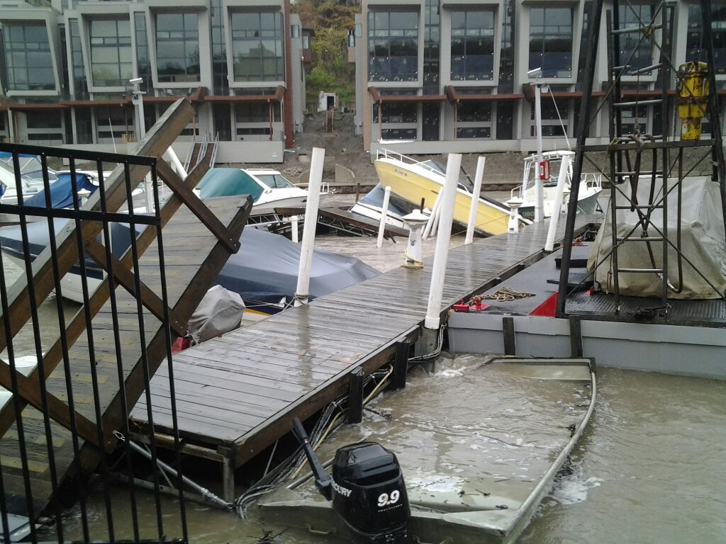
0300 AM NON-TSTM WND DMG CLEVELAND 41.48N 81.68W
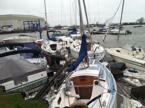
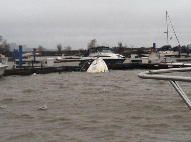
10/30/2012 CUYAHOGA OH BROADCAST MEDIA
30 PLEASURE BOATS SANK AND 12 DRIFTED AWAY FROM SEVERAL
MARINAS ALONG CLEVELANDS LAKESHORE.
0400 AM NON-TSTM WND DMG WOOSTER 40.82N 81.93W
10/30/2012 WAYNE OH NEWSPAPER
FEW TREES DOWN...DAMAGE TO A HOME AND FENCE.
|