
A storm system will shift from eastern Texas into the lower Mississippi Valley Monday with additional threats of severe thunderstorms and heavy to excessive rainfall which may bring flooding. A Flood Watch remains in effect. In the northern U.S., a storm will bring heavy snow and gusty winds over parts of the northern Rockies, northern Plains, and Upper Midwest Monday into Wednesday. Read More >
Duluth, MN
Weather Forecast Office
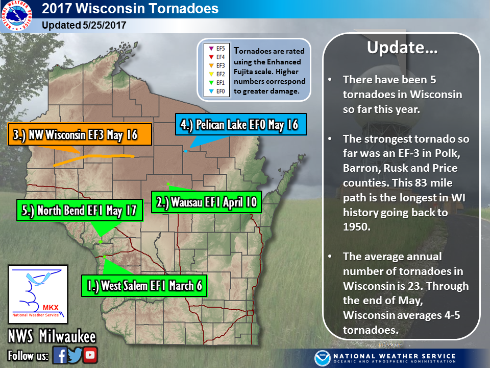
The tornado which traveled through northern Wisconsin on May 16, 2017, is now the tornado with the longest track of continuous damage in Wisconsin since modern tornado records began in 1950. The tornado's path was 83 miles long. The hardest hit areas were just north of Chetek, Wisconsin, where EF-2 damage was found, and in the Conrath area where EF-3 damage occurred. EF-0 to EF-1 damage occurred along the remainder of the tornado's path. This is the first EF-3 tornado in the state since the Verona tornado in 2014. The EF-Scale is the Enhanced Fujita Scale of tornado damage where an EF-0 is the weakest tornado and an EF-5 is the strongest. See below for the latest information.
Forecasts
Fire Weather
Great Lakes
Local Text Products
Winter Weather
Local Area Forecasts
Aviation
Marine
Rainy River Basin Page
Current Conditions
Current Observations
Public Information Statements
National Snowfall Map
NOHRSC Snow Analysis
Rain/Snow Reports
Winter Monitor
US Dept of Commerce
National Oceanic and Atmospheric Administration
National Weather Service
Duluth, MN
5027 Miller Trunk Highway
Duluth, MN 55811-1442
218-729-6697 - Duluth; 218-283-4615 - Intl Falls
Comments? Questions? Please Contact Us.

