
Cold temperatures will continue across much of the eastern U.S. into today. Heavy lake effect snow continues into today east of Lakes Erie and Ontario. Two Pacific cold fronts will cross the Pacific Northwest early this week followed by another atmospheric river. Heavy rain and gusty winds are expected through midweek, with the potential for renewed urban and river flooding. Read More >
|
Welcome to the new NWS Duluth Marine Page. Any questions or comments can be sent to nws.duluth@noaa.gov.
|
| Duluth | Marquette | |||
 |
 |
|||
| Reflectivity | Reflectivity | |||
Nearshore Forecast
142
FZUS53 KDLH 152208
NSHDLH
Nearshore Marine Forecast
National Weather Service Duluth MN
408 PM CST Mon Dec 15 2025
For waters within five nautical miles of shore on Lake Superior.
Waves are the significant wave height - the average of the highest
1/3 of the wave spectrum. Occasional wave height is the average of
the highest 1/10 of the wave spectrum.
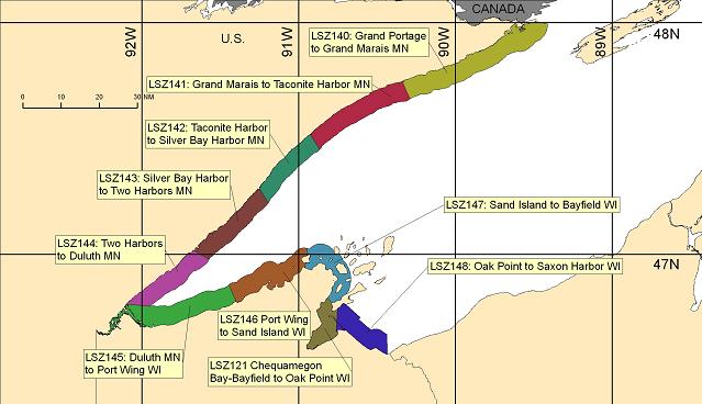
LSZ140-160500-
Grand Portage to Grand Marais MN-
408 PM CST Mon Dec 15 2025
...GALE WARNING IN EFFECT FROM TUESDAY MORNING THROUGH LATE
TUESDAY NIGHT...
.TONIGHT...North wind 5 knots becoming west late in the evening,
then becoming southwest 10 to 15 knots with gusts to around
20 knots after midnight rising to 20 to 25 knots with gusts to
around 30 knots late in the night. Slight chance of light
freezing rain late in the night. Waves 1 to 2 feet building to
3 to 5 feet late in the night. Waves occasionally to 7 feet.
.TUESDAY...Southwest wind up to 30 knots. Gusts up to 35 knots
increasing to 40 knots in the late morning and early afternoon,
then decreasing to 35 knots late in the afternoon. Slight chance
of light freezing rain and light sleet in the morning. Waves 8 to
11 feet. Waves occasionally to 15 feet.
.TUESDAY NIGHT...West wind 20 to 25 knots with gales to around
40 knots becoming northwest 15 to 20 knots with gales to around
40 knots after midnight. Mostly cloudy in the evening then
becoming partly cloudy. Waves 7 to 10 feet subsiding to 2 to
4 feet. Waves occasionally to 13 feet.
.WEDNESDAY...West wind 10 to 15 knots with gusts to around
20 knots becoming southwest 15 to 20 knots with gusts to around
30 knots in the afternoon. Slight chance of snow in the
afternoon. Waves 1 to 2 feet building to 2 to 4 feet in the
afternoon. A small craft advisory may be needed.
$$
LSZ141-160500-
Grand Marais to Taconite Harbor MN-
408 PM CST Mon Dec 15 2025
...GALE WARNING IN EFFECT FROM TUESDAY MORNING THROUGH LATE
TUESDAY NIGHT...
.TONIGHT...Northwest wind 5 knots becoming west late in the
evening, then becoming southwest 10 to 15 knots with gusts to
around 25 knots after midnight. Slight chance of light freezing
rain late in the night. Waves 1 foot or less building to 1 to
3 feet late in the night.
.TUESDAY...Southwest wind 20 to 25 knots. Gusts up to 30 knots
increasing to 35 knots in the late morning and afternoon. Slight
chance of light freezing rain and light sleet in the morning.
Waves 4 to 6 feet building to 6 to 9 feet in the late morning and
afternoon. Waves occasionally to 12 feet.
.TUESDAY NIGHT...West wind 20 to 25 knots with gales to around
40 knots becoming northwest 10 to 15 knots with gusts to around
30 knots early in the morning. Mostly cloudy in the evening then
becoming partly cloudy. Waves 4 to 7 feet subsiding to 1 to
3 feet. Waves occasionally to 9 feet.
.WEDNESDAY...West wind 5 to 10 knots becoming southwest 10 to
15 knots with gusts to around 25 knots in the afternoon. Slight
chance of snow in the afternoon. Waves 1 to 2 feet.
$$
LSZ142-160500-
Taconite Harbor to Silver Bay Harbor MN-
408 PM CST Mon Dec 15 2025
...GALE WARNING IN EFFECT TUESDAY EVENING...
.TONIGHT...Variable winds 10 knots or less becoming west 5 knots
late in the evening, then becoming southwest 10 to 15 knots with
gusts to around 25 knots after midnight. Slight chance of light
freezing rain late in the night. Waves 1 to 2 feet.
.TUESDAY...Southwest wind 20 to 25 knots. Gusts up to 30 knots
increasing to 35 knots late in the afternoon. Slight chance of
light freezing rain and snow in the morning. Waves 4 to 6 feet.
Waves occasionally to 8 feet. A gale warning may be needed.
.TUESDAY NIGHT...West wind 15 to 20 knots with gales to around
40 knots easing to 5 to 10 knots with gusts to around 25 knots
early in the morning. Partly cloudy. Waves 3 to 5 feet subsiding
to 1 to 3 feet after midnight.
.WEDNESDAY...West wind 5 knots becoming southwest with gusts to
around 25 knots in the afternoon. Slight chance of snow in the
afternoon. Waves 1 to 2 feet.
$$
LSZ143-160500-
Silver Bay Harbor to Two Harbors MN-
408 PM CST Mon Dec 15 2025
...GALE WARNING IN EFFECT TUESDAY EVENING...
.TONIGHT...West wind 5 knots becoming southwest 10 to 15 knots
with gusts to around 25 knots after midnight. Slight chance of
light freezing rain late in the night. Waves 1 foot or less
building to 1 to 3 feet late in the night.
.TUESDAY...Southwest wind 20 to 25 knots. Gusts up to 30 knots
increasing to 35 knots late in the afternoon. Slight chance of
light freezing rain and snow in the morning. Waves 4 to 7 feet.
Waves occasionally to 9 feet. A gale warning may be needed.
.TUESDAY NIGHT...West wind 15 to 20 knots. Gusts up to 35 knots
increasing to 40 knots late in the evening, then decreasing to
35 knots after midnight decreasing to 25 knots early in the
morning. Partly cloudy. Waves 3 to 5 feet subsiding to 1 to
3 feet after midnight. Waves occasionally to 7 feet.
.WEDNESDAY...West wind 5 to 10 knots becoming southwest 10 to
15 knots with gusts to around 30 knots in the afternoon. Slight
chance of snow and rain in the afternoon. Waves 1 to 2 feet
building to 1 to 3 feet late in the afternoon.
$$
LSZ144-160500-
Two Harbors to Duluth MN-
408 PM CST Mon Dec 15 2025
...GALE WARNING IN EFFECT TUESDAY EVENING...
.TONIGHT...West wind 5 knots becoming southwest 15 to 20 knots in
the late evening and overnight. Slight chance of light freezing
rain late in the night. Waves 1 foot or less building to 1 to
3 feet late in the night.
.TUESDAY...Southwest wind 20 to 25 knots. Gusts up to 30 knots
increasing to 35 knots late in the afternoon. Slight chance of
light freezing rain and snow in the morning. Waves 4 to 6 feet.
Waves occasionally to 8 feet. A gale warning may be needed.
.TUESDAY NIGHT...West wind 20 to 25 knots with gales to around
35 knots easing to 10 to 15 knots with gusts to around 20 knots
early in the morning. Partly cloudy. Waves 3 to 5 feet subsiding
to 1 to 2 feet early in the morning. Waves occasionally to
7 feet.
.WEDNESDAY...Southwest wind 5 to 10 knots becoming south 15 to
20 knots with gusts to around 30 knots in the afternoon. Slight
chance of rain and snow in the afternoon. Waves 1 to 2 feet
building to 2 to 4 feet late in the afternoon.
$$
LSZ145-160500-
Duluth MN to Port Wing WI-
408 PM CST Mon Dec 15 2025
...GALE WARNING IN EFFECT TUESDAY EVENING...
.TONIGHT...Southwest wind 15 to 20 knots with gusts to around
25 knots. Partly cloudy early in the evening then becoming mostly
cloudy. Waves 1 to 2 feet building to 1 to 3 feet late in the
night.
.TUESDAY...Southwest wind 20 to 25 knots. Gusts up to 30 knots
increasing to 35 knots in the afternoon. Slight chance of light
freezing rain and snow in the morning. Waves 4 to 6 feet. Waves
occasionally to 8 feet. A gale warning may be needed.
.TUESDAY NIGHT...West wind 20 to 25 knots with gales to around
35 knots easing to 10 to 15 knots with gusts to around 20 knots
early in the morning. Mostly cloudy in the evening then becoming
partly cloudy. Waves 4 to 7 feet subsiding to 2 to 4 feet early
in the morning. Waves occasionally to 9 feet.
.WEDNESDAY...Southwest wind 5 to 10 knots with gusts to around
20 knots rising to 10 to 15 knots with gusts to around 20 knots
early in the afternoon, then becoming south 20 to 25 knots with
gusts to around 30 knots late in the afternoon. Slight chance of
rain and snow in the afternoon. Waves 1 to 2 feet building to
1 to 3 feet late in the afternoon. A small craft advisory may be
needed.
$$
LSZ146-160500-
Port Wing to Sand Island WI-
408 PM CST Mon Dec 15 2025
...GALE WARNING IN EFFECT FROM TUESDAY MORNING THROUGH TUESDAY
EVENING...
.TONIGHT...Southwest wind 5 to 10 knots with gusts to around
20 knots rising to 15 to 20 knots with gusts to around 25 knots
late in the night. Mostly cloudy. Waves 1 to 2 feet building to
1 to 3 feet late in the night.
.TUESDAY...Southwest wind 20 to 25 knots. Gusts up to 30 knots
increasing to 35 knots in the late morning and afternoon. Slight
chance of light freezing rain in the morning. Waves 3 to 5 feet
building to 5 to 8 feet in the late morning and afternoon. Waves
occasionally to 10 feet.
.TUESDAY NIGHT...West wind 20 to 25 knots with gales to around
35 knots easing to 10 to 15 knots with gusts to around 25 knots
early in the morning. Mostly cloudy in the evening then becoming
partly cloudy. Waves 5 to 8 feet subsiding to 2 to 4 feet early
in the morning. Waves occasionally to 10 feet.
.WEDNESDAY...West wind 5 to 10 knots with gusts to around
20 knots becoming southwest 10 to 15 knots with gusts to around
20 knots in the afternoon. Slight chance of rain and snow in the
afternoon. Waves 1 to 2 feet.
$$
LSZ147-160500-
Sand Island to Bayfield WI-
408 PM CST Mon Dec 15 2025
...GALE WARNING IN EFFECT FROM TUESDAY MORNING THROUGH TUESDAY
EVENING...
.TONIGHT...Southwest wind 10 to 15 knots with gusts to around
20 knots. Mostly cloudy. Waves 1 to 2 feet.
.TUESDAY...Southwest wind 20 to 25 knots. Gusts up to 30 knots
increasing to 35 knots in the late morning and afternoon. Slight
chance of light freezing rain and snow in the morning. Waves 2 to
4 feet building to 4 to 7 feet in the late morning and afternoon.
Waves occasionally to 9 feet.
.TUESDAY NIGHT...West wind 20 to 25 knots with gales to around
35 knots easing to 10 to 15 knots with gusts to around 25 knots
early in the morning. Mostly cloudy in the evening then becoming
partly cloudy. Waves 4 to 7 feet subsiding to 2 to 4 feet early
in the morning. Waves occasionally to 9 feet.
.WEDNESDAY...West wind 5 to 10 knots with gusts to around
20 knots becoming south 10 to 15 knots with gusts to around
25 knots in the afternoon. Slight chance of rain and snow in the
afternoon. Waves 1 to 2 feet.
$$
LSZ150-160500-
Outer Apostle Islands Beyond 5 NM from Mainland-
408 PM CST Mon Dec 15 2025
...GALE WARNING IN EFFECT FROM TUESDAY MORNING THROUGH TUESDAY
EVENING...
.TONIGHT...West wind 5 knots becoming southwest 10 to 15 knots
with gusts to around 25 knots in the late evening and overnight.
Mostly cloudy. Waves 1 to 2 feet building to 1 to 3 feet late in
the night.
.TUESDAY...Southwest wind 20 to 25 knots. Gusts up to 30 knots
increasing to 35 knots in the late morning and afternoon. Slight
chance of light freezing rain and snow in the morning. Waves 3 to
5 feet building to 5 to 8 feet in the late morning and afternoon.
Waves occasionally to 11 feet.
.TUESDAY NIGHT...West wind 20 to 25 knots. Gales up to 40 knots
decreasing to 25 knots. Mostly cloudy in the evening then
becoming partly cloudy. Waves 5 to 8 feet subsiding to 3 to
5 feet early in the morning. Waves occasionally to 11 feet.
.WEDNESDAY...West wind 5 to 10 knots with gusts to around
20 knots becoming southwest with gusts to around 20 knots early
in the afternoon, then becoming south 15 to 20 knots with gusts
to around 25 knots late in the afternoon. Slight chance of snow
in the afternoon. Waves 1 to 3 feet building to 2 to 4 feet late
in the afternoon.
$$
LSZ121-160500-
Chequamegon Bay-Bayfield to Oak Point WI-
408 PM CST Mon Dec 15 2025
.TONIGHT...Southwest wind 10 to 15 knots with gusts to around
20 knots. Mostly cloudy. Waves 1 foot or less.
.TUESDAY...Southwest wind 15 to 20 knots. Gusts up to 25 knots
increasing to 30 knots in the late morning and afternoon. Slight
chance of light freezing rain and snow in the morning. Waves 1 to
2 feet.
.TUESDAY NIGHT...West wind 15 to 20 knots. Gusts up to 30 knots
decreasing to 20 knots early in the morning. Partly cloudy. Waves
1 to 2 feet.
.WEDNESDAY...Southwest wind 5 to 10 knots becoming south 10 to
15 knots with gusts to around 25 knots in the afternoon. Mostly
sunny. Waves 1 foot or less.
$$
LSZ148-160500-
Oak Point to Saxon Harbor WI-
408 PM CST Mon Dec 15 2025
.TONIGHT...Southwest wind 5 to 10 knots rising to 15 to 20 knots
with gusts to around 25 knots late in the night. Mostly cloudy.
Waves 1 to 2 feet.
.TUESDAY...Southwest wind 15 to 20 knots with gusts to around
30 knots. Slight chance of light freezing rain and snow in the
morning. Waves 2 to 4 feet.
.TUESDAY NIGHT...West wind 20 to 25 knots with gusts to around
30 knots easing to 10 to 15 knots with gusts to around 25 knots
early in the morning. Mostly cloudy in the evening then becoming
partly cloudy. Waves 2 to 4 feet. A small craft advisory may be
needed.
.WEDNESDAY...Southwest wind 5 to 10 knots with gusts to around
20 knots becoming south 15 to 20 knots with gusts to around
30 knots in the afternoon. Partly sunny. Waves 1 to 3 feet.
$$
Graphical marine forecasts are available online at:
weather.gov/greatlakes
WFO DLH
Open Waters Forecast
233
FZUS63 KMQT 152101
GLFLS
Open Lake Forecast for Lake Superior
National Weather Service Marquette MI
400 PM EST Mon Dec 15 2025
For waters beyond 5 nautical miles of shore on Lake Superior.
Waves are the significant wave height - the average of the
highest 1/3 of the wave spectrum. Occasional wave height is the
average of the highest 1/10 of the wave spectrum.
.SYNOPSIS...
A 29.9 inch trough over the east half of the lake this afternoon
will exit into northeastern Ontario this evening. This trough is
then followed by a weak 30.0 inch ridge tonight. Tuesday, a 29.2
inch trough crosses the lake as the 29.0 inch parent low tracks
across northern Ontario. Weak ridging of 29.9 inches then returns on
Wednesday. Wednesday evening through Thursday morning, a 29.0 inch
Alberta Clipper tracks from the Canadian Prairie to western Lake
Superior, weakening to 29.2 inches as it progresses. The low crosses
the lake Thursday, followed by 30.1 inch ridging on Friday
associated with a 30.2 minch high over the Lower Mississippi Valley.
Another low pressure of around 29.5 inches tracks near the Upper
Great Lakes Saturday with ridging to follow late in the weekend.
LSZ162-160900-
Lake Superior west of a line from Saxon Harbor WI to Grand
Portage MN beyond 5NM-
400 PM EST Mon Dec 15 2025 /300 PM CST Mon Dec 15 2025/
...GALE WARNING IN EFFECT FROM TUESDAY MORNING THROUGH LATE
TUESDAY NIGHT...
.LATE THIS AFTERNOON...Northwest winds 5 to 15 knots. Waves calm
to 2 feet.
.TONIGHT...Northwest winds 5 to 15 knots backing southwest by
midnight, then increasing to 15 to 25 knots late. Waves building
to 3 to 5 feet occasionally to 7 feet.
.TUESDAY...Southwest gales to 40 knots. A slight chance of
freezing rain, snow showers and sleet in the morning. Waves
building to 9 to 12 feet occasionally to 15 feet.
.TUESDAY NIGHT...West gales to 40 knots becoming northwest 20 to
30 knots late. Waves subsiding to 2 to 4 feet.
.WEDNESDAY...West winds 10 to 20 knots becoming southwest 15 to
25 knots in the afternoon. A slight chance of snow showers in the
afternoon. Waves subsiding to calm to 2 feet, then building to
2 to 4 feet.
.WEDNESDAY NIGHT...South gales to 35 knots veering southwest
after midnight. A chance of rain showers, possibly mixed with
freezing rain in the evening. A chance of snow showers. Rain
showers likely after midnight. Waves building to 5 to 8 feet
occasionally to 10 feet.
.THURSDAY...North gales to 45 knots. Rain showers likely in the
morning. Snow showers likely. Freezing spray in the afternoon.
Waves building to 8 to 12 feet occasionally to 15 feet.
.THURSDAY NIGHT...North gales to 45 knots diminishing to 20 to
30 knots after midnight. Heavy freezing spray in the evening.
Waves subsiding to 1 to 3 feet.
.FRIDAY...South winds 15 to 25 knots increasing to 20 to
30 knots. A chance of snow showers, then snow showers likely.
Waves subsiding to calm to 2 feet, then building to 5 to 8 feet
occasionally to 10 feet.
.SATURDAY...West winds 20 to 30 knots becoming northwest 15 to
25 knots. Waves subsiding to calm to 2 feet.
Note, wave height forecasts are for ice free areas.
$$
LSZ263-160900-
Lake Superior from Saxon Harbor WI to Upper Entrance to Portage
Canal MI 5NM off shore to the US/Canadian border including Isle
Royale National Park-
400 PM EST Mon Dec 15 2025
...GALE WARNING IN EFFECT FROM TUESDAY MORNING THROUGH LATE
TUESDAY NIGHT...
.LATE THIS AFTERNOON...Northwest winds 5 to 15 knots. Waves 1 to
3 feet.
.TONIGHT...Northwest winds 5 to 15 knots becoming southwest 10 to
20 knots by midnight, then increasing to 20 to 30 knots late.
Waves subsiding to calm to 2 feet, then building to 3 to 5 feet
occasionally to 7 feet.
.TUESDAY...Southwest gales to 40 knots. A slight chance of
freezing rain and sleet in the morning. Waves building to 10 to
14 feet occasionally to 18 feet.
.TUESDAY NIGHT...West gales to 40 knots becoming northwest gales
to 35 knots late. Waves subsiding to 5 to 8 feet occasionally to
10 feet.
.WEDNESDAY...West winds 15 to 25 knots backing southwest in the
afternoon. Waves subsiding to 1 to 3 feet, then building to 3 to
5 feet occasionally to 7 feet.
.WEDNESDAY NIGHT...South gales to 35 knots veering southwest
after midnight. A chance of rain showers in the evening. A chance
of snow showers. Rain showers likely after midnight. Waves
building to 7 to 10 feet occasionally to 13 feet.
.THURSDAY...North gales to 40 knots increasing to storm force
winds to 55 knots in the afternoon. Rain showers likely in the
morning. Snow showers likely. Freezing spray in the afternoon.
Waves building to 12 to 17 feet occasionally to 21 feet.
.THURSDAY NIGHT...North storm force winds to 55 knots diminishing
to gales to 40 knots after midnight. A chance of snow showers in
the evening. Heavy freezing spray. Waves subsiding to 3 to 6 feet
occasionally to 8 feet.
.FRIDAY...North winds 15 to 25 knots becoming south gales to
35 knots. A chance of snow showers, then snow showers likely.
Freezing spray. Waves subsiding to 1 to 3 feet, then building to
6 to 9 feet occasionally to 11 feet.
.SATURDAY...West gales to 35 knots becoming northwest 20 to
30 knots. Waves subsiding to 2 to 4 feet.
Note, wave height forecasts are for ice free areas.
$$
LSZ264-160900-
Lake Superior from Upper Entrance to Portage Canal to Manitou
Island MI 5NM off shore to the US/Canadian Border-
400 PM EST Mon Dec 15 2025
...GALE WARNING IN EFFECT FROM TUESDAY MORNING THROUGH WEDNESDAY
MORNING...
.LATE THIS AFTERNOON...Northwest winds 10 to 20 knots. Waves 2 to
4 feet.
.TONIGHT...North winds 5 to 15 knots backing southwest by
midnight, then increasing to 15 to 25 knots late. Waves subsiding
to calm to 2 feet, then building to 3 to 5 feet occasionally to
7 feet.
.TUESDAY...Southwest gales to 40 knots. A chance of freezing
rain, snow showers, sleet and rain showers in the morning. Waves
building to 10 to 14 feet occasionally to 18 feet.
.TUESDAY NIGHT...West gales to 45 knots becoming northwest gales
to 40 knots late. A slight chance of rain showers in the evening.
A slight chance of snow showers after midnight. Waves building to
11 to 15 feet occasionally to 19 feet, then subsiding to 8 to
11 feet occasionally to 14 feet.
.WEDNESDAY...Northwest winds 20 to 30 knots becoming southwest
15 to 25 knots in the afternoon. Waves subsiding to 1 to 3 feet,
then building to 3 to 5 feet occasionally to 7 feet.
.WEDNESDAY NIGHT...South winds 20 to 30 knots increasing to gales
to 35 knots after midnight. A chance of rain showers in the
evening. A chance of snow showers. Rain showers likely after
midnight. Waves building to 8 to 12 feet occasionally to 15 feet.
.THURSDAY...North gales to 40 knots increasing to storm force
winds to 55 knots in the afternoon. Rain showers in the morning.
Snow showers. Heavy freezing spray in the afternoon. Waves
building to 15 to 20 feet occasionally to 25 feet.
.THURSDAY NIGHT...North storm force winds to 55 knots diminishing
to gales to 45 knots after midnight. Heavy freezing spray. A
chance of snow showers. Waves subsiding to 5 to 8 feet
occasionally to 10 feet.
.FRIDAY...North winds 15 to 25 knots becoming south gales to
35 knots. Freezing spray. Snow showers likely. Waves subsiding to
2 to 4 feet, then building to 9 to 12 feet occasionally to
15 feet.
.SATURDAY...West gales to 35 knots veering northwest. Freezing
spray. Waves subsiding to 3 to 5 feet occasionally to 7 feet.
Note, wave height forecasts are for ice free areas.
$$
LSZ265-160900-
Lake Superior West of Line from Manitou Island to Marquette MI
Beyond 5NM from shore-
400 PM EST Mon Dec 15 2025
...GALE WARNING IN EFFECT FROM TUESDAY AFTERNOON THROUGH
WEDNESDAY MORNING...
.LATE THIS AFTERNOON...Northwest winds 15 to 25 knots. A slight
chance of snow showers. Waves 2 to 4 feet.
.TONIGHT...Northwest winds 10 to 20 knots backing southwest by
midnight. Waves subsiding to calm to 2 feet, then building to
1 to 3 feet.
.TUESDAY...South winds 15 to 25 knots becoming southwest gales to
35 knots. A chance of sleet, rain showers, freezing rain and snow
showers in the morning. Waves building to 4 to 7 feet
occasionally to 9 feet.
.TUESDAY NIGHT...West gales to 45 knots veering northwest late. A
slight chance of rain and snow showers after midnight. Waves
building to 7 to 11 feet occasionally to 14 feet.
.WEDNESDAY...Northwest gales to 35 knots becoming south 15 to
25 knots in the afternoon. Waves subsiding to 1 to 3 feet, then
building to 2 to 4 feet.
.WEDNESDAY NIGHT...South gales to 40 knots. A chance of rain and
snow showers. Waves building to 8 to 11 feet occasionally to
14 feet, then subsiding to 6 to 9 feet occasionally to 11 feet.
.THURSDAY...South gales to 40 knots becoming north storm force
winds to 55 knots in the afternoon. Rain showers in the morning,
then snow showers in the afternoon. Freezing spray in the
afternoon. Waves subsiding to 5 to 8 feet occasionally to
10 feet, then building to 15 to 20 feet occasionally to 25 feet.
.THURSDAY NIGHT...North storm force winds to 55 knots diminishing
to gales to 45 knots after midnight. Freezing spray. Snow showers
likely in the evening. A chance of snow showers after midnight.
Waves building to 17 to 22 feet occasionally to 28 feet, then
subsiding to 8 to 11 feet occasionally to 14 feet.
.FRIDAY...North winds 20 to 30 knots becoming south gales to
35 knots. A chance of snow showers, then snow showers likely.
Freezing spray. Waves subsiding to 2 to 4 feet, then building to
6 to 9 feet occasionally to 11 feet.
.SATURDAY...West gales to 40 knots veering northwest. A chance of
snow showers. Waves subsiding to 2 to 4 feet.
Note, wave height forecasts are for ice free areas.
$$
LSZ266-160900-
Lake Superior East of a line from Manitou Island to Marquette MI
and West of a line from Grand Marais MI to the US/Canadian Border
Beyond 5NM from shore-
400 PM EST Mon Dec 15 2025
...GALE WARNING IN EFFECT FROM TUESDAY MORNING THROUGH WEDNESDAY
MORNING...
.LATE THIS AFTERNOON...Northwest winds 15 to 25 knots. A slight
chance of snow showers. Waves 3 to 6 feet occasionally to 8 feet.
.TONIGHT...Northwest winds 10 to 20 knots backing west by
midnight, then becoming southwest 15 to 25 knots late. Waves
subsiding to 1 to 3 feet, then building to 2 to 4 feet.
.TUESDAY...South gales to 35 knots veering southwest by mid
afternoon. A chance of freezing rain, possibly mixed with sleet,
rain and snow showers in the morning. Waves building to 10 to
14 feet occasionally to 18 feet.
.TUESDAY NIGHT...Southwest gales to 40 knots becoming northwest
gales to 45 knots late. A chance of snow showers, possibly mixed
with rain. Waves building to 12 to 17 feet occasionally to
21 feet.
.WEDNESDAY...Northwest gales to 35 knots becoming southwest 20 to
30 knots in the afternoon. Waves subsiding to 3 to 6 feet
occasionally to 8 feet.
.WEDNESDAY NIGHT...South gales to 40 knots. A chance of rain and
snow showers. Waves building to 11 to 15 feet occasionally to
19 feet, then subsiding to 10 to 14 feet occasionally to 18 feet.
.THURSDAY...South gales to 40 knots becoming north storm force
winds to 55 knots in the afternoon. Rain showers in the morning,
then snow showers in the afternoon. Freezing spray in the
afternoon. Waves subsiding to 8 to 11 feet occasionally to
14 feet, then building to 15 to 20 feet occasionally to 25 feet.
.THURSDAY NIGHT...North storm force winds to 55 knots diminishing
to gales to 45 knots after midnight. Heavy freezing spray. Snow
showers in the evening. A chance of snow showers after midnight.
Waves building to 20 to 25 feet occasionally to 31 feet, then
subsiding to 10 to 14 feet occasionally to 18 feet.
.FRIDAY...North winds 20 to 30 knots becoming south gales to
40 knots. Freezing spray. A chance of snow showers. Snow showers.
Waves subsiding to 3 to 5 feet occasionally to 7 feet, then
building to 10 to 14 feet occasionally to 18 feet.
.SATURDAY...West gales to 40 knots veering northwest. A chance of
snow showers. Freezing spray. Waves subsiding to 4 to 7 feet
occasionally to 9 feet.
Note, wave height forecasts are for ice free areas.
$$
LSZ267-160900-
Lake Superior from Grand Marais MI to Whitefish Point MI 5NM off
shore to the US/Canadian border-
400 PM EST Mon Dec 15 2025
...GALE WARNING IN EFFECT FROM TUESDAY MORNING THROUGH WEDNESDAY
MORNING...
.LATE THIS AFTERNOON...Northwest winds 20 to 30 knots. A chance
of snow showers. Waves 4 to 7 feet occasionally to 9 feet.
.TONIGHT...Northwest winds 15 to 25 knots becoming west 10 to
20 knots by midnight, then becoming southwest 15 to 25 knots
late. A slight chance of snow showers in the evening. Waves
subsiding to 1 to 3 feet, then building to 2 to 4 feet.
.TUESDAY...South winds 20 to 30 knots increasing to gales to
40 knots by late morning, then veering southwest by mid
afternoon. A chance of freezing rain and snow showers in the
morning. A chance of rain showers. Waves building to 8 to 11 feet
occasionally to 14 feet.
.TUESDAY NIGHT...Southwest gales to 35 knots becoming northwest
gales to 45 knots late. A chance of rain showers. A chance of
snow showers after midnight. Waves subsiding to 7 to 10 feet
occasionally to 13 feet, then building to 12 to 17 feet
occasionally to 21 feet.
.WEDNESDAY...Northwest gales to 40 knots becoming west 15 to
25 knots in the afternoon. Waves subsiding to 3 to 5 feet
occasionally to 7 feet.
.WEDNESDAY NIGHT...South gales to 40 knots. A chance of freezing
rain in the evening. A chance of rain showers, possibly mixed
with snow. Waves building to 7 to 11 feet occasionally to
14 feet.
.THURSDAY...South gales to 35 knots becoming north gales to
40 knots in the afternoon. Rain showers. Snow showers in the
afternoon. Waves building to 12 to 17 feet occasionally to
21 feet.
.THURSDAY NIGHT...North gales to 45 knots. Heavy freezing spray.
Snow showers in the evening. A chance of snow showers after
midnight. Waves subsiding to 8 to 11 feet occasionally to
14 feet.
.FRIDAY...North winds 20 to 30 knots becoming south gales to
35 knots. Freezing spray. A chance of snow showers. Snow showers.
Waves subsiding to 2 to 4 feet, then building to 7 to 10 feet
occasionally to 13 feet.
.SATURDAY...West gales to 35 knots veering northwest. Snow
showers likely, then a chance of snow showers. Freezing spray.
Waves subsiding to 6 to 9 feet occasionally to 11 feet, then
building to 7 to 10 feet occasionally to 13 feet.
Note, wave height forecasts are for ice free areas.
$$
LSZ261-160300-
MAFOR 1522/
Superior West...GALE WARNING IN EFFECT...11710 11700 11520 11530
12540 12550. Waves 2 feet or less building to 2 to 4 feet
tonight. Waves 3 to 6 feet building to 8 to 12 feet Tuesday.
Superior North Central...GALE WARNING IN EFFECT...11720 11810
11610 11530 11540 13550. A chance of light freezing rain and
light sleet Tuesday morning. Waves 2 to 4 feet subsiding to 1 to
2 feet, then building to 2 to 4 feet tonight. Waves 4 to 7 feet
building to 10 to 14 feet Tuesday.
Superior South Central...GALE WARNING IN EFFECT...12720 11610
11520 11430 11440 12540. Waves 3 to 5 feet subsiding to 1 to 3
feet tonight. Waves 3 to 5 feet building to 5 to 8 feet Tuesday.
Superior East...GALE WARNING IN EFFECT...11730 11720 11710 11520
11540 12450 11550. A chance of snow showers early this evening. A
chance of light freezing rain Tuesday morning, then a chance of
rain showers Tuesday afternoon. Waves 5 to 7 feet subsiding to 2
to 4 feet tonight. Waves 3 to 6 feet building to 9 to 12 feet
Tuesday.
$$
WFO MQT
Experimental modernized open lake forecast is available online at
weather.gov/mqt/glftable
Graphical marine forecasts are available online at:
weather.gov/greatlakes
Other Information
Great Lakes Water Levels and Forecasts - Provided by USACE
GLERL - NOAA Great Lakes Forecast System


 This product is only issued between May 26th and October 1st.