Overview
|
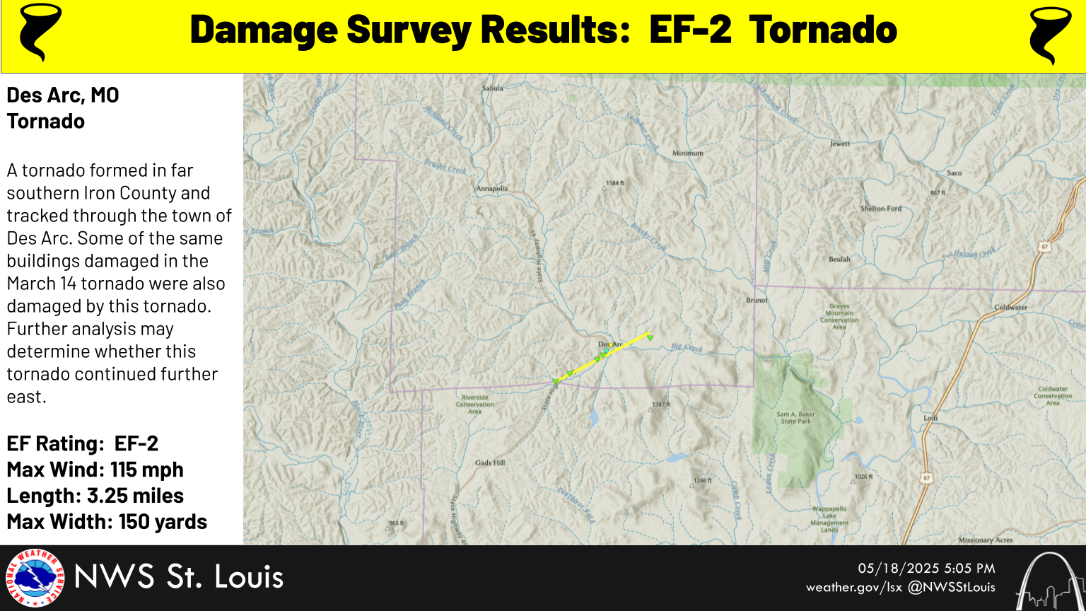
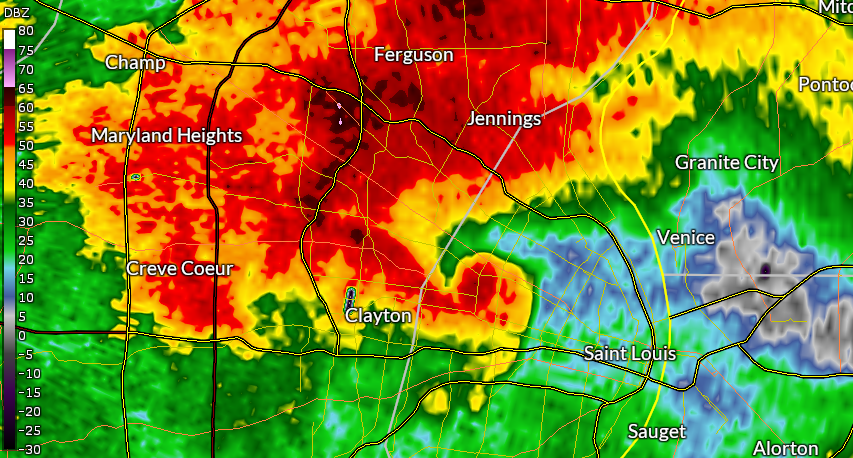
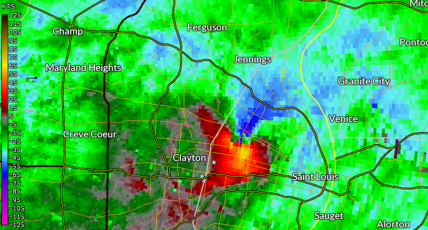
Numerous severe thunderstorms developed over Missouri on the afternoon of Friday, May 16, and raced northeast. A tornado touched down in Clayton around 2:41 pm, and quickly strengthened as it moved through the northern portions of the city of St. Louis. It was rated at EF3 intensity across this area, with maximum winds up to 152 mph. The tornado crossed the Mississippi River and entered Illinois near Venice, tracking through Granite City and Pontoon Beach before lifting near the SIU-Edwardsville campus. A second tornado occurred in southern Iron County in south central Missouri, and moved through Des Arc. This tornado was rated EF2, and damaged some of the same structures that were impacted by the March 14th tornado. |
  |
 |
 |
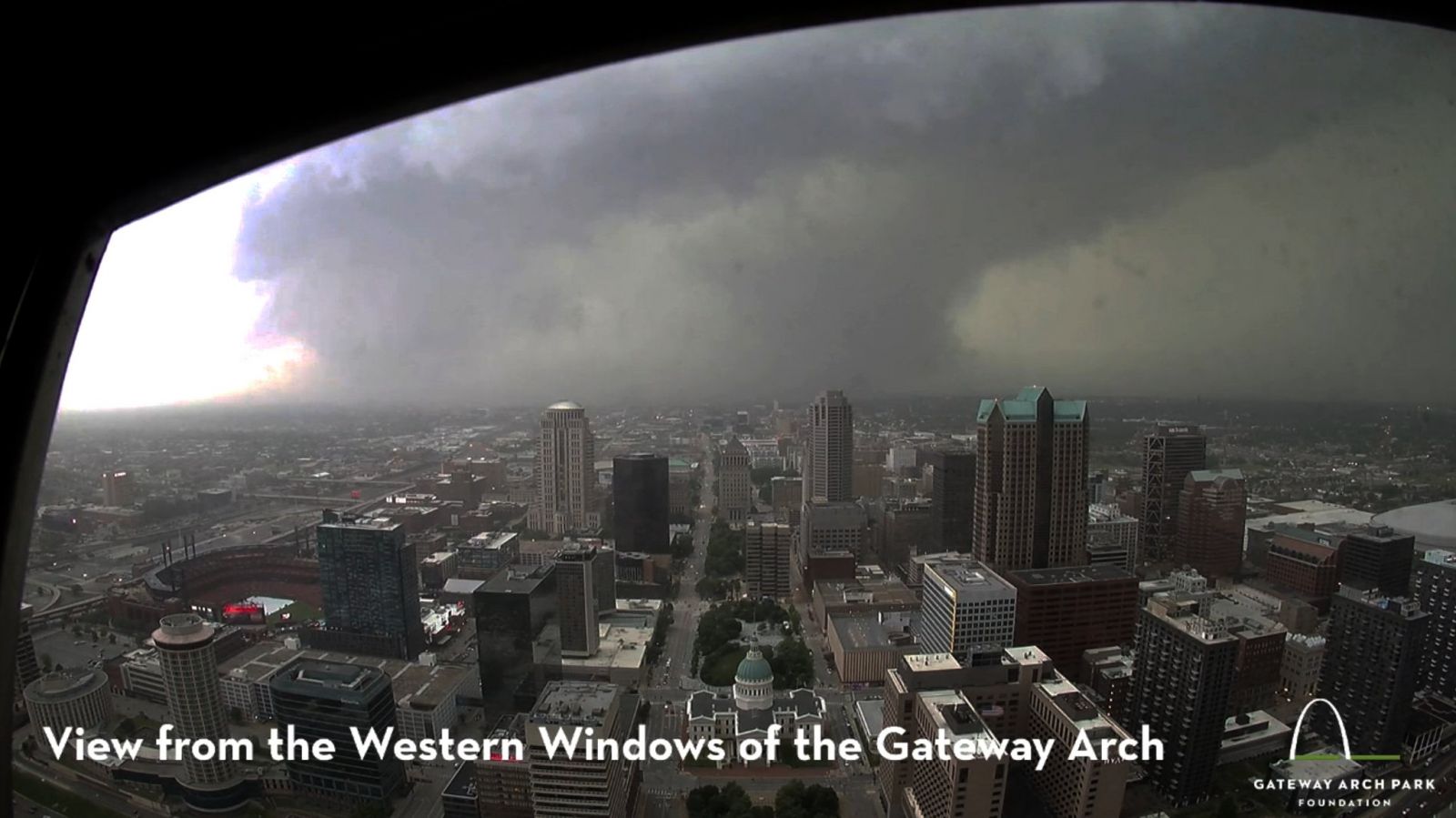 |
| KLSX base reflectivity image from 2:43 pm, showing a hook echo east of Clayton | KLSX storm relative motion image from 2:43 pm, with the tornado seen where the orange and blue shades come together | View from the Gateway Arch. Webcam photo from Gateway Arch Park Foundation |
Tornadoes
Select a tornado from the table to zoom into the track and view more information. The default table view is limited to 8 tracks, but can be scrolled by a mouse wheel or dynamically expanded. Additionally, the table can fill the entire window by clicking the small circular expanding arrow icon at the very top right of the table and returned to its original size by clicking the button again. The side information panel that opens over the map can be closed using the "X" on the upper right corner of the pop-up. Zoom into the map and click damage points to see detailed information and pictures from the surveys.
|
NOTE: times shown below are local to your device's time zone. |

The Enhanced Fujita (EF) Scale classifies tornadoes into the following categories:
| EF0 Weak 65-85 mph |
EF1 Moderate 86-110 mph |
EF2 Significant 111-135 mph |
EF3 Severe 136-165 mph |
EF4 Extreme 166-200 mph |
EF5 Catastrophic 200+ mph |
 |
|||||
| Tornadoes that fail to impact any ratable structures on the EF-Scale are rated EF-Unknown (EF-U) | |||||
Storm Reports
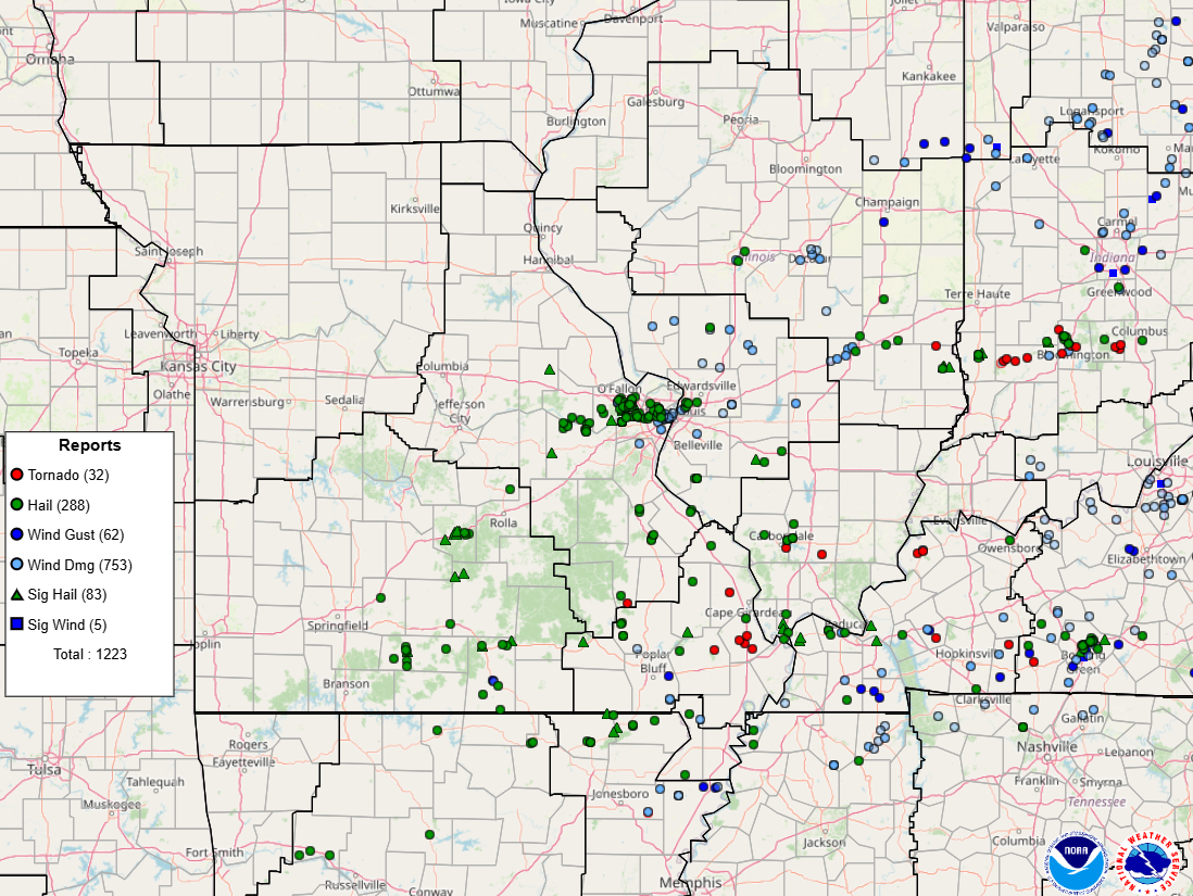
Map of local storm reports, courtesy of the Storm Prediction Center.
Interactive database available at this link.
..TIME...   ...EVENT...      ...CITY LOCATION...     ...LAT.LON...
..DATE...   ....MAG....      ..COUNTY LOCATION..ST.. ...SOURCE....
            ..REMARKS..

0221 AM     Tstm Wnd Dmg     3 WNW Chesterfield      38.67N 90.63W
05/16/2025                   St. Louis          MO   Public

            Windows of business shattered and numerous
            injuries reported. Reported via email.

0255 AM     Tstm Wnd Dmg     3 ESE Highland          38.73N 89.63W
05/16/2025                   Madison            IL   Public

            Large tree branches snapped.

0137 PM     Hail             3 S New Haven           38.57N 91.22W
05/16/2025  M1.50 Inch       Franklin           MO   Public


0141 PM     Hail             2 ESE New Haven         38.60N 91.18W
05/16/2025  M1.00 Inch       Franklin           MO   Trained Spotter


0143 PM     Hail             2 E New Haven           38.59N 91.18W
05/16/2025  E1.00 Inch       Franklin           MO   Public

            Report from mPING: Quarter (1.00 in.).

0144 PM     Hail             2 E Holstein            38.65N 91.14W
05/16/2025  M1.00 Inch       Warren             MO   Public

            Report from mPING: Quarter (1.00 in.).

0145 PM     Hail             Bellflower              39.00N 91.35W
05/16/2025  E2.00 Inch       Montgomery         MO   Emergency Mngr

            Emergency management relayed a photo of
            large hail. Time estimated by radar.

0147 PM     Hail             New Haven               38.61N 91.22W
05/16/2025  E1.00 Inch       Franklin           MO   Public

            Report from mPING: Quarter (1.00 in.).

0150 PM     Hail             Marthasville            38.63N 91.06W
05/16/2025  M1.75 Inch       Warren             MO   Emergency Mngr

            Warren County EM reported golf ball sized
            hail at Marthasville.

0151 PM     Hail             Dutzow                  38.60N 91.00W
05/16/2025  E1.75 Inch       Warren             MO   Public


0152 PM     Hail             Dutzow                  38.61N 90.99W
05/16/2025  M1.75 Inch       Warren             MO   Trained Spotter


0153 PM     Hail             Gerald                  38.40N 91.33W
05/16/2025  M2.00 Inch       Franklin           MO   Broadcast Media

            Video sent in by local broadcast media.
            Courtesy of KSDK. Time estimated by radar.

0200 PM     Hail             New Melle               38.71N 90.88W
05/16/2025  E1.00 Inch       St. Charles        MO   Public

            time estimated.

0200 PM     Hail             2 SE New Melle          38.68N 90.86W
05/16/2025  E1.00 Inch       St. Charles        MO   Public

            Report from mPING: Quarter (1.00 in.).

0202 PM     Tstm Wnd Dmg     3 WSW Saint Clair       38.33N 91.02W
05/16/2025                   Franklin           MO   Emergency Mngr

            Multiple reports of vehicle accidents along
            I-44. Several trees and wires down
            throughout the county. Time estimated by
            radar.

0205 PM     Hail             Washington              38.55N 91.01W
05/16/2025  M1.25 Inch       Franklin           MO   Local Official

            Washington School District official
            submitted a photo of half dollar size hail.
            Time estimated by radar.

0205 PM     Hail             Washington              38.56N 91.02W
05/16/2025  E1.00 Inch       Franklin           MO   Emergency Mngr

            Washington EM reported 1-inch hail.

0205 PM     Hail             Washington              38.55N 91.01W
05/16/2025  M1.00 Inch       Franklin           MO   Emergency Mngr


0206 PM     Hail             Washington              38.56N 91.01W
05/16/2025  E1.00 Inch       Franklin           MO   Public


0207 PM     Hail             1 NE O'Fallon           38.79N 90.70W
05/16/2025  E1.00 Inch       St. Charles        MO   Public

            time estimated.

0207 PM     Hail             1 S Washington          38.55N 91.01W
05/16/2025  M1.75 Inch       Franklin           MO   Public

            Report from mPING: Golf Ball (1.75 in.).

0210 PM     Tstm Wnd Dmg     1 ENE Dardenne Prairie  38.76N 90.72W
05/16/2025                   St. Charles        MO   Trained Spotter

            Power lines down near Highway N between
            Highway K and Bryan Road.

0210 PM     Tstm Wnd Dmg     1 N Dardenne Prairie    38.76N 90.73W
05/16/2025                   St. Charles        MO   Emergency Mngr

            12 power poles down near Highway N and Money
            Drive.

0212 PM     Hail             1 S O'Fallon            38.77N 90.71W
05/16/2025  E1.25 Inch       St. Charles        MO   Public

            Report from mPING: Half Dollar (1.25 in.).

0213 PM     Hail             Defiance                38.63N 90.78W
05/16/2025  M2.00 Inch       St. Charles        MO   Trained Spotter


0215 PM     Hail             3 SSE Dardenne Prairie  38.71N 90.71W
05/16/2025  M1.75 Inch       St. Charles        MO   Public

            Golf ball sized hail 3ENE of our office
            specifically.

0215 PM     Tstm Wnd Dmg     1 NE Dardenne Prairie   38.76N 90.72W
05/16/2025                   St. Charles        MO   NWS Employee

            4 power poles snapped/down, cutting off the
            entrance/exit to a neighborhood. Time
            estimated from radar.

0218 PM     Hail             3 NW Wildwood           38.62N 90.69W
05/16/2025  E1.50 Inch       St. Louis          MO   Public

            Report from mPING: Ping Pong Ball (1.50
            in.).

0218 PM     Hail             3 NW Wildwood           38.62N 90.69W
05/16/2025  E1.00 Inch       St. Louis          MO   Public

            Report from mPING: Quarter (1.00 in.).

0218 PM     Hail             2 WSW Weldon Spring     38.70N 90.68W
05/16/2025  M2.00 Inch       St. Charles        MO   NWS Employee

            Hail persisted for 10+ minutes.

0218 PM     Hail             2 WSW Weldon Spring     38.71N 90.68W
05/16/2025  M2.00 Inch       St. Charles        MO   Trained Spotter


0218 PM     Hail             2 SE Dardenne Prairie   38.74N 90.70W
05/16/2025  E1.00 Inch       St. Charles        MO   Public

            Report from mPING: Quarter (1.00 in.).

0218 PM     Tstm Wnd Dmg     1 N Dardenne Prairie    38.76N 90.73W
05/16/2025                   St. Charles        MO   Public

            Several power lines downed.

0218 PM     Hail             1 NE Dardenne Prairie   38.77N 90.72W
05/16/2025  E1.00 Inch       St. Charles        MO   Public

            Report from mPING: Quarter (1.00 in.).

0219 PM     Hail             3 NW Wildwood           38.62N 90.69W
05/16/2025  E1.75 Inch       St. Louis          MO   Public

            Corrects previous hail report from 3 NW
            Wildwood. Report from mPING: Golf Ball (1.75
            in.).

0220 PM     Hail             3 NW Wildwood           38.62N 90.69W
05/16/2025  E1.75 Inch       St. Louis          MO   Public

            Report from mPING: Golf Ball (1.75 in.).

0220 PM     Hail             Saint Peters            38.78N 90.60W
05/16/2025  E1.00 Inch       St. Charles        MO   Public

            time estimated.

0220 PM     Hail             1 S Harvester           38.74N 90.58W
05/16/2025  M2.00 Inch       St. Charles        MO   Public


0220 PM     Hail             Weldon Spring           38.72N 90.65W
05/16/2025  M1.50 Inch       St. Charles        MO   Public

            time estimated.

0221 PM     Hail             3 NW Wildwood           38.62N 90.69W
05/16/2025  E1.00 Inch       St. Louis          MO   Public

            Report from mPING: Quarter (1.00 in.).

0221 PM     Hail             1 NW Cottleville        38.76N 90.66W
05/16/2025  E1.00 Inch       St. Charles        MO   Public

            Report from mPING: Quarter (1.00 in.).

0221 PM     Hail             1 SE Cottleville        38.74N 90.64W
05/16/2025  E1.00 Inch       St. Charles        MO   Public

            Report from mPING: Quarter (1.00 in.).

0222 PM     Hail             3 NW Wildwood           38.62N 90.69W
05/16/2025  E1.00 Inch       St. Louis          MO   Public

            Report from mPING: Quarter (1.00 in.).

0223 PM     Hail             4 S Weldon Spring       38.66N 90.65W
05/16/2025  E1.75 Inch       St. Louis          MO   Public

            Report from mPING: Golf Ball (1.75 in.).

0223 PM     Hail             2 SW Cottleville        38.73N 90.68W
05/16/2025  M1.25 Inch       St. Charles        MO   Trained Spotter


0224 PM     Hail             4 SE Weldon Spring      38.66N 90.65W
05/16/2025  M1.75 Inch       St. Louis          MO   Trained Spotter

            Corrects previous hail report from 4 S
            Weldon Spring.

0224 PM     Hail             1 NW Chesterfield       38.66N 90.59W
05/16/2025  E1.75 Inch       St. Louis          MO   Public

            Report from mPING: Golf Ball (1.75 in.).

0224 PM     Hail             1 ENE Chesterfield      38.66N 90.56W
05/16/2025  M2.00 Inch       St. Louis          MO   Local Official

            City of Chesterfield official submitted a
            photo of 2 inch hail.

0224 PM     Hail             2 SW Saint Peters       38.76N 90.62W
05/16/2025  E1.50 Inch       St. Charles        MO   Broadcast Media

            Photo submitted courtesy of Spectrum News.

0224 PM     Hail             1 NE Weldon Spring      38.73N 90.63W
05/16/2025  E1.25 Inch       St. Charles        MO   Public

            60 mph estimated winds as well.

0224 PM     Hail             1 N Weldon Spring       38.73N 90.65W
05/16/2025  E2.00 Inch       St. Charles        MO   NWS Employee


0224 PM     Hail             1 WNW Harvester         38.76N 90.60W
05/16/2025  M1.75 Inch       St. Charles        MO   Trained Spotter


0225 PM     Hail             2 NE Saint Peters       38.80N 90.57W
05/16/2025  E1.25 Inch       St. Charles        MO   Public

            Report from mPING: Half Dollar (1.25 in.).

0225 PM     Hail             Cottleville             38.75N 90.65W
05/16/2025  M2.00 Inch       St. Charles        MO   Public

            Photo submitted via social media.

0225 PM     Hail             2 SW Harvester          38.73N 90.60W
05/16/2025  E1.25 Inch       St. Charles        MO   Public

            Report from mPING: Half Dollar (1.25 in.).

0225 PM     Hail             2 W Harvester           38.74N 90.62W
05/16/2025  E2.50 Inch       St. Charles        MO   Public

            Report from mPING: Tennis Ball (2.50 in.).

0225 PM     Hail             Harvester               38.75N 90.58W
05/16/2025  E2.00 Inch       St. Charles        MO   Public


0225 PM     Hail             2 WSW Harvester         38.74N 90.61W
05/16/2025  M1.75 Inch       St. Charles        MO   Public

            picture received on X. time estimated from
            radar.

0226 PM     Hail             3 NW Clarkson Valley    38.65N 90.65W
05/16/2025  E1.25 Inch       St. Louis          MO   Public

            Report from mPING: Half Dollar (1.25 in.).

0226 PM     Hail             2 E Chesterfield        38.66N 90.54W
05/16/2025  M2.00 Inch       St. Louis          MO   Public


0226 PM     Hail             1 NW Harvester          38.76N 90.59W
05/16/2025  E2.00 Inch       St. Charles        MO   Public

            Report from mPING: Hen Egg (2.00 in.).

0227 PM     Hail             2 E Chesterfield        38.66N 90.54W
05/16/2025  E1.75 Inch       St. Louis          MO   Public

            Report from mPING: Golf Ball (1.75 in.).

0227 PM     Hail             Saint Peters            38.78N 90.60W
05/16/2025  M1.50 Inch       St. Charles        MO   Public


0227 PM     Hail             2 W Harvester           38.74N 90.62W
05/16/2025  E1.75 Inch       St. Charles        MO   Public

            Report from mPING: Golf Ball (1.75 in.).

0229 PM     Hail             2 E Chesterfield        38.66N 90.55W
05/16/2025  M1.00 Inch       St. Louis          MO   Trained Spotter


0229 PM     Hail             3 E Chesterfield        38.65N 90.53W
05/16/2025  E1.00 Inch       St. Louis          MO   Public


0230 PM     Hail             4 NE Chesterfield       38.68N 90.53W
05/16/2025  E1.00 Inch       St. Louis          MO   Public

            time estimated.

0230 PM     Hail             2 W Harvester           38.74N 90.62W
05/16/2025  E2.00 Inch       St. Charles        MO   Public

            Report from mPING: Hen Egg (2.00 in.).

0232 PM     Hail             1 N Town And Country    38.64N 90.48W
05/16/2025  E1.25 Inch       St. Louis          MO   Public

            Report from mPING: Half Dollar (1.25 in.).

0233 PM     Hail             1 NE Chesterfield       38.67N 90.56W
05/16/2025  E1.50 Inch       St. Louis          MO   Public

            Report from mPING: Ping Pong Ball (1.50
            in.).

0233 PM     Tstm Wnd Dmg     High Ridge              38.46N 90.53W
05/16/2025                   Jefferson          MO   Emergency Mngr

            Numerous trees and wire down in northern
            Jefferson County around the High Ridge and
            Saline Valley area. Time estimated by radar.

0234 PM     Hail             2 E Chesterfield        38.66N 90.55W
05/16/2025  E1.25 Inch       St. Louis          MO   Public

            Report from mPING: Half Dollar (1.25 in.).

0235 PM     Hail             1 SE Overland           38.69N 90.36W
05/16/2025  E1.25 Inch       St. Louis          MO   Public


0235 PM     Hail             Creve Coeur             38.66N 90.44W
05/16/2025  E1.00 Inch       St. Louis          MO   Public

            time estimated.

0235 PM     Tstm Wnd Gst     Creve Coeur             38.66N 90.44W
05/16/2025  M60 MPH          St. Louis          MO   Public

            reported measured gust. time estimated.

0235 PM     Hail             2 W Frontenac           38.64N 90.45W
05/16/2025  E1.00 Inch       St. Louis          MO   Public

            Report from mPING: Quarter (1.00 in.).

0237 PM     Hail             1 SSW Saint John        38.70N 90.35W
05/16/2025  E1.25 Inch       St. Louis          MO   Public

            Hail in Overland and Charlack.

0237 PM     Tstm Wnd Dmg     1 W Clayton             38.64N 90.34W
05/16/2025                   St. Louis          MO   Public

            Twisted power poles and trees down and
            twisted guttering. Damage path was narrow.

0238 PM     Hail             Woodson Terrace         38.73N 90.37W
05/16/2025  E1.00 Inch       St. Louis          MO   Public

            Report from mPING: Quarter (1.00 in.).

0240 PM     Tstm Wnd Dmg     1 E Clayton             38.65N 90.31W
05/16/2025                   St. Louis          MO   Public

            large trees and fences blown over on
            Washington University Campus.

0240 PM     Tstm Wnd Dmg     1 E Richmond Heights    38.63N 90.31W
05/16/2025                   St. Louis          MO   Public

            At St. Marys Hospital insulation and metal
            objects were blown and scattered throughout
            the area. Windows were blown out of the
            building and numerous large tree branches
            were snapped on property. Report via email.

0240 PM     Tstm Wnd Dmg     Carrollton              39.30N 90.41W
05/16/2025                   Greene             IL   Emergency Mngr

            Trees and powerlines down. Time estimated by
            radar.
0241 PM     Tornado          Richmond Heights        38.63N 90.33W
05/16/2025                   St. Louis          MO   NWS Storm Survey

            *** 5 FATAL, 38 INJ ***
            Storm survey determined an EF3 tornado began
            near Clayton and tracked northeast through
            the city of St Louis and continued into
            Illinois. It dissipated near SIU
            Edwardsville. Thousands of buildings were
            damaged in the city of St Louis from this
            tornado.
0241 PM     Tstm Wnd Dmg     1 W Clayton             38.64N 90.34W
05/16/2025                   St. Louis          MO   Broadcast Media

            Report courtesy of KMOV. Time estimated by
            radar.

0241 PM     Tstm Wnd Dmg     2 WNW Saint Louis       38.65N 90.28W
05/16/2025                   St. Louis City     MO   Public

            Significant damage to apartment complex.
            What looks like parts of the building are
            laying within the complexs interior
            courtyard. Balcony bars are bent and nearly
            falling off the windows. Windows are
            shattered.

0241 PM     Tstm Wnd Dmg     1 WNW Saint Louis       38.64N 90.26W
05/16/2025                   St. Louis City     MO   Trained Spotter

            Numerous trees down across the area.

0241 PM     Tstm Wnd Dmg     Greenfield              39.34N 90.21W
05/16/2025                   Greene             IL   Law Enforcement

            Numerous large trees snapped.

0242 PM     Tstm Wnd Dmg     2 WNW Saint Louis       38.65N 90.28W
05/16/2025                   St. Louis City     MO   Public

            5655 Pershing Avenue in west St. Louis
            experienced considerable wind damage to the
            apartment building, including windows blown
            out.

0243 PM     Tstm Wnd Dmg     1 SE Saint Ann          38.72N 90.37W
05/16/2025                   St. Louis          MO   Emergency Mngr

            Cell tower damaged. Several buildings
            damaged with broken windows.

0243 PM     Hail             1 SE Olivette           38.66N 90.37W
05/16/2025  E1.50 Inch       St. Louis          MO   Public

            Report from mPING: Ping Pong Ball (1.50
            in.).

0243 PM     Tstm Wnd Dmg     1 WNW Brentwood         38.62N 90.36W
05/16/2025                   St. Louis          MO   Trained Spotter

            Several trees down on Pine Ave.

0243 PM     Tstm Wnd Dmg     1 E Clayton             38.64N 90.30W
05/16/2025                   St. Louis City     MO   Fire Dept/Rescue

            Northwest Fire District relayed a report of
            large trees down off Woodbourne Drive just
            southwest of Wydown Boulevard and Skinker.

0243 PM     Tstm Wnd Dmg     1 WNW Saint Louis       38.64N 90.26W
05/16/2025                   St. Louis City     MO   Broadcast Media

            Several trees down on West Pine Blvd. Power
            is out in the neighborhood. Courtesy of
            KSDK. Time estimated by radar.

0243 PM     Tstm Wnd Dmg     1 NW Saint Louis        38.64N 90.26W
05/16/2025                   St. Louis City     MO   Public

            Several large trees down on Maryland Ave in
            West St. Louis.

0243 PM     Tstm Wnd Dmg     Belleville              38.53N 90.00W
05/16/2025                   St. Clair          IL   Emergency Mngr

            Several calls received over northern St.
            Clair County for trees and power lines down.
            Time estimated by radar.

0244 PM     Hail             1 SW Saint John         38.71N 90.35W
05/16/2025  E1.50 Inch       St. Louis          MO   Public

            Report from mPING: Ping Pong Ball (1.50
            in.).

0244 PM     Tstm Wnd Dmg     1 S Hillsdale           38.67N 90.29W
05/16/2025                   St. Louis City     MO   Public

            Significant front porch damage to residence
            along Plymouth Avenue.

0245 PM     Hail             2 W Overland            38.70N 90.40W
05/16/2025  M1.00 Inch       St. Louis          MO   Public


0246 PM     Hail             University City         38.67N 90.33W
05/16/2025  E2.00 Inch       St. Louis          MO   Public

            Photo submitted via social media.

0246 PM     Hail             1 ENE Olivette          38.68N 90.36W
05/16/2025  M1.75 Inch       St. Louis          MO   Trained Spotter

            Photo submitted via email.

0246 PM     Hail             1 W Normandy            38.71N 90.32W
05/16/2025  M2.50 Inch       St. Louis          MO   Trained Spotter

            Photo submitted via email. Hail fell near
            Clearview and Hatherly in north city.

0246 PM     Tstm Wnd Dmg     3 E Uplands Park        38.68N 90.22W
05/16/2025                   St. Louis City     MO   Dept of Highways

            Missouri DOT reported tree debris littering
            I-70 at Carrie.

0246 PM     Tstm Wnd Dmg     2 NNE Saint Louis       38.66N 90.23W
05/16/2025                   St. Louis City     MO   Public

            Multiple trees down, others broken off at
            the top, and cell phone tower damaged at
            Courion Industries.

0247 PM     Hail             1 N University City     38.68N 90.33W
05/16/2025  E1.00 Inch       St. Louis          MO   Public


0250 PM     Tstm Wnd Dmg     1 NW Saint Louis        38.65N 90.26W
05/16/2025                   St. Louis City     MO   Public

            4-foot diameter tree down at McPherson
            Avenue and Taylor Avenue.

0251 PM     Tstm Wnd Dmg     1 SW Granite City       38.70N 90.14W
05/16/2025                   Madison            IL   Trained Spotter

            Damage in the area including trees and a
            snapped flag pole.

0252 PM     Tstm Wnd Dmg     2 SSW Mitchell          38.75N 90.10W
05/16/2025                   Madison            IL   Trained Spotter

            15-inch tree down at the roots with
            quarter-size hail.
0253 PM     Tornado          1 WSW Des Arc           37.28N 90.66W
05/16/2025                   Iron               MO   NWS Storm Survey

            A tornado touched down in Des Arc and
            tracked for at least 3.25 miles. Some
            buildings damaged by a tornado on Mar 14
            were damaged again by this tornado.
0254 PM     Hail             1 NW Clayton            38.65N 90.33W
05/16/2025  E1.50 Inch       St. Louis          MO   Public

            Report from mPING: Ping Pong Ball (1.50
            in.).

0254 PM     Tstm Wnd Dmg     1 NE Clayton            38.66N 90.31W
05/16/2025                   St. Louis          MO   Trained Spotter

            Large tree down onto power lines.

0254 PM     Hail             2 NE Granite City       38.73N 90.10W
05/16/2025  M1.00 Inch       Madison            IL   Amateur Radio

            HAM Radio operator report near Pontoon Road
            and Maryville Road in Granite City.

0255 PM     Tornado          1 N Des Arc             37.30N 90.64W
05/16/2025                   Iron               MO   911 Call Center

            Missouri State Highway Patrol reported a
            tornado on the ground near Annapolis. Damage
            unknown at the time of report. Time of event
            estimated by radar.

0255 PM     Hail             1 W Red Bud             38.21N 90.02W
05/16/2025  E1.25 Inch       Randolph           IL   Public

            Report from mPING: Half Dollar (1.25 in.).

0255 PM     Tstm Wnd Dmg     Highland                38.74N 89.68W
05/16/2025                   Madison            IL   Public

            A large branch snapped from a large healthy
            tree.

0255 PM     Tstm Wnd Dmg     Bunker Hill             39.04N 89.95W
05/16/2025                   Macoupin           IL   Amateur Radio

            12 inch tree limbs down. Estimated wind
            speeds of 70 mph. Time estimated by radar.

0257 PM     Hail             1 S Mitchell            38.75N 90.08W
05/16/2025  E1.00 Inch       Madison            IL   Public

            Report from mPING: Quarter (1.00 in.).

0257 PM     Hail             1 SW Mitchell           38.76N 90.10W
05/16/2025  E1.00 Inch       Madison            IL   Public

            Report from mPING: Quarter (1.00 in.).

0258 PM     Hail             Red Bud                 38.21N 90.00W
05/16/2025  M2.00 Inch       Randolph           IL   Public

            Corrects previous hail report from Red Bud.

0259 PM     Tstm Wnd Dmg     2 S Saint Jacob         38.68N 89.76W
05/16/2025                   Madison            IL   Amateur Radio

            HAM radio operator relayed reports of a tree
            down across summerfield road and lilac road.

0300 PM     Hail             Red Bud                 38.21N 90.00W
05/16/2025  M1.75 Inch       Randolph           IL   Public

            pictures received on X. time estimated.

0301 PM     Hail             2 W Glen Carbon         38.76N 90.00W
05/16/2025  E1.00 Inch       Madison            IL   Public

            Report from mPING: Quarter (1.00 in.).

0302 PM     Tstm Wnd Dmg     Highland                38.74N 89.68W
05/16/2025                   Madison            IL   Amateur Radio

            Tree down. Power pole and transformer taken
            down by tree.

0305 PM     Tstm Wnd Dmg     1 ENE Granite City      38.72N 90.11W
05/16/2025                   Madison            IL   Public

            Numerous tree limbs down with structural
            damage to several homes along Emert Avenue
            and Johnson Road in Granite City.

0305 PM     Tstm Wnd Dmg     Staunton                39.01N 89.79W
05/16/2025                   Macoupin           IL   Public

            received a picture of a large tree down.
            time estimated.

0314 PM     Tstm Wnd Dmg     2 S Butler              39.17N 89.53W
05/16/2025                   Montgomery         IL   Fire Dept/Rescue

            Trees down near Route 16 and Route 127. Time
            estimated by radar.

0315 PM     Tstm Wnd Dmg     Taylor Springs          39.13N 89.49W
05/16/2025                   Montgomery         IL   Public

            pictures received on X of a few small trees
            uprooted. Time estimated.

0317 PM     Tstm Wnd Dmg     Patoka                  38.75N 89.09W
05/16/2025                   Marion             IL   Emergency Mngr

            Multiple power poles down.

0317 PM     Tstm Wnd Dmg     Carlinville             39.28N 89.88W
05/16/2025                   Macoupin           IL   Law Enforcement

            Tree damage throughout town.

0317 PM     Hail             Carlinville             39.29N 89.88W
05/16/2025  M1.00 Inch       Macoupin           IL   Emergency Mngr

            Time estimated by radar.

0326 PM     Hail             Annapolis               37.36N 90.70W
05/16/2025  M1.75 Inch       Iron               MO   911 Call Center

            Officer reported golf ball size hail in
            Annapolis.

0335 PM     Hail             3 SE Addieville         38.35N 89.45W
05/16/2025  M2.00 Inch       Washington         IL   Public

            Public report of 2 inch hail 4W Nashville.

0335 PM     Hail             1 S Nashville           38.33N 89.38W
05/16/2025  M1.00 Inch       Washington         IL   Public

            pictures received on X. time estimated.

0352 PM     Hail             3 NW Richview           38.41N 89.22W
05/16/2025  E1.00 Inch       Washington         IL   Public

            Report from mPING: Quarter (1.00 in.).

0400 PM     Hail             3 NNE Bonne Terre       37.97N 90.53W
05/16/2025  M1.75 Inch       St. Francois       MO   NWS Employee

            NWS employee relayed a report from a family
            member.

0403 PM     Hail             4 SSW Valles Mill       37.99N 90.53W
05/16/2025  E1.00 Inch       St. Francois       MO   Public


0414 PM     Hail             1 NW Ste. Genevieve     37.98N 90.05W
05/16/2025  E1.00 Inch       Ste. Genevieve     MO   Public

            Report from mPING: Quarter (1.00 in.).

0415 PM     Hail             1 W Ste. Genevieve      37.97N 90.06W
05/16/2025  M1.00 Inch       Ste. Genevieve     MO   Public

            Quarter-inch hail fell at US 61 and Market
            Street in Ste. Genevieve.

0453 PM     Hail             1 NE Farmington         37.79N 90.41W
05/16/2025  M1.75 Inch       St. Francois       MO   Amateur Radio

            Report near KREI Radio in Farmington.

0455 PM     Hail             2 NE Farmington         37.80N 90.40W
05/16/2025  E1.50 Inch       St. Francois       MO   Public

            Report from mPING: Ping Pong Ball (1.50
            in.).

0455 PM     Hail             1 S Farmington          37.76N 90.42W
05/16/2025  E1.00 Inch       St. Francois       MO   Public

            Report from mPING: Quarter (1.00 in.).

0457 PM     Hail             1 NE Farmington         37.79N 90.41W
05/16/2025  E1.00 Inch       St. Francois       MO   Public

            Report from mPING: Quarter (1.00 in.).

0500 PM     Hail             1 S Bridgeton           38.75N 90.43W
05/16/2025  E1.00 Inch       St. Louis          MO   Public

            Quarter-sized hail at St. Charles Rock Road
            and McKelvey Road.

0515 PM     Hail             1 SW Saint John         38.71N 90.35W
05/16/2025  E1.75 Inch       St. Louis          MO   Public


0754 PM     Tstm Wnd Dmg     1 NNW Affton            38.56N 90.33W
05/16/2025                   St. Louis          MO   Public

            picture of a damaged carport received on X.
            time estimated.

0328 AM     Tstm Wnd Dmg     4 SSE Atwater           39.28N 89.70W
05/17/2025                   Montgomery         IL   Public

            A brick outbuilding had its roof taken off
            and walls collapsed by thunderstorm winds.
            Report via email.
Photos & Video
Clayton and Richmond Heights
| Crestwood Dr. (NWS survey) |
Fontbonne College (NWS survey) |
Fontbonne College (NWS survey) |
Big Bend Blvd. (NWS survey) |
Forest Park Area
| St. Louis Zoo (NWS survey) |
St. Louis Zoo (NWS survey) |
Pershing Ave. (NWS survey) |
Lindell Blvd. (NWS survey) |
Fountain Park and Kingsway Neighborhoods
| Shops at Roberts Village (NWS survey) |
Page Blvd. (NWS survey) |
Kingshighway at Cabanne (NWS survey) |
Kingshighway at Cates (NWS survey) |
| Newstead Ave. (NWS survey) |
Newstead Ave. (NWS survey) |
Newstead Ave. (NWS survey) |
Vine Grove Ave. (NWS survey) |
O'Fallon Park Area
| Penrose St. (NWS survey) |
Harris Ave. (NWS survey) |
O'Fallon Park (NWS survey) |
Hall St. (NWS survey) |
Granite City and Pontoon Beach
| Lewis and Clark Blvd. (NWS survey) |
W. 1st St. (NWS survey) |
Johnson Rd. (NWS survey) |
Eastgate Dr. (NWS survey) |
SIU-Edwardsville Area
| Chain of Rocks Rd. (NWS survey) |
Sunset Hills Country Club (NWS survey) |
SIU-E Campus (NWS survey) |
SIU-E Campus (NWS survey) |
Des Arc
| Front St. (NWS survey) |
Front St. (NWS survey) |
Route 49 (NWS survey) |
Route 143 (NWS survey) |
 |
Media use of NWS Web News Stories is encouraged! Please acknowledge the NWS as the source of any news information accessed from this site. |
|


 Weather Story
 Weather Map
 Local Radar