Event Overview
Ernesto was the costliest tropical cyclone of the 2006 Atlantic hurricane season. The sixth tropical storm and first hurricane of the season, Ernesto (Figure 1) developed from a tropical wave on August 24 in the eastern Caribbean Sea. Ernesto first affected the northern Caribbean, reaching minimal hurricane status near Haiti before weakening and moving across eastern Cuba as a tropical storm. Despite initial predictions for it to track through the eastern Gulf of America as a major hurricane, Ernesto moved across eastern Florida as a weak tropical storm. After turning to the northeast, it re-intensified and made landfall in Brunswick County, North Carolina near Long Beach (Figure 2) at 1130 PM on Thursday, August 31. Ernesto moved north across the Coastal Plain of North Carolina on Friday, September 1, reaching southeastern Virginia as a Tropical Depression during the late afternoon on Friday. The system becameextratropical late Friday evening as it moved across eastern Virginia.
Figure 1. Track of Ernesto across the Caribbean and up the East Coast, August 24 to September 1, 2006.
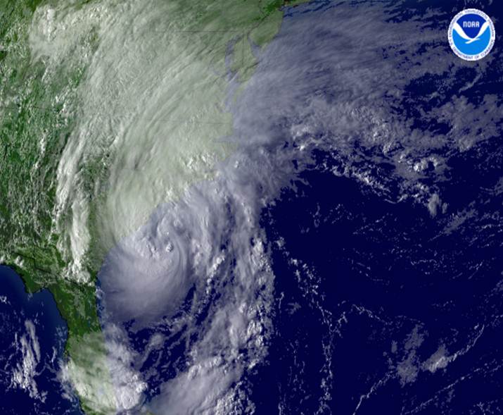
Figure 2. Tropical Storm Ernesto approaching the North Carolina/South Carolina border on August 31, 2006.
Evolution and Impacts
Ernesto was the sixth named storm, and the first hurricane of the 2006 Atlantic hurricane season, forming from a vigorous tropical wave that exited the African coast on August 18. After forming, Ernesto briefly attained hurricane status early on August 27 while south of Haiti. However, interaction with the mountainous terrain of Haiti weakened Ernesto to a Tropical Storm with maximum sustained winds of 60 mph. After the weakening, Ernesto never again attained Hurricane strength, remaining a Tropical Storm until it was over Central Florida, when it weakened to a Depression. After becoming a Depression, Ernesto moved northeast into the Atlantic and once again strengthened into a 70 mph Tropical Storm before making landfall near the North Carolina/South Carolina border.
After landfall, strong Tropical Storm Ernesto moved across the Coastal Plains of eastern North Carolina during the early morning hours of September 1, 2006. Wind gusts ranged from 40 to 60 mph, with the highest gusts to near 70 mph along coastal sections of Onslow County. Minor storm surge flooding and beach erosion occurred along the Onslow and Carteret county coastline and on the Neuse River. The most significant storm surge effects occurred along the Pamlico and Pungo Rivers in Beaufort County where estimated water level rises of 4 to 6 feet resulting in flooding of many roads, low-lying areas, homes and businesses in Washington, Whichards Beach and Belhaven. A 2 to 4 foot surge was reported at New Bern with some street flooding in the downtown area. Soundside flooding also occurred on the eastern part of the Pamlico Sound in Dare County, where a 3 foot surge was observed at Collington Harbor with several structures flooded and an estimated fifty thousand dollars in damage occurred. Minor soundside flooding also occurred on the western part of the Pamlico Sound across eastern Pamlico County with a 1 to 2 foot surge. A 2 to 3 foot surge occurred along coastal sections of Onslow and Carteret counties resulting in minor beach erosion.
Heavy rainfall during the evening of August 31 through the early morning hours of September 1 (Figure 3), resulted in extensive flooding of low-lying areas, roads and streams across eastern North Carolina, mainly west of the Highway 17 corridor. Areal flood warnings were issued for most of the county warning area as Ernesto moved across the Coastal Plains counties of eastern North Carolina. Duplin County was hardest hit with many primary roads flooded including a 12 mile stretch of Interstate 40. Many streams and roads across the Coastal Plains remained flooded for several days. Evacuations of many homes, and rescues due to high water were required for many locations across the county, especially near Chinquapin. The Northeast Cape Fear River near Chinquapin rose to major flooding levels on the 2ndand remained in major flooding status through the 7th. The river crested at 18.8 feet. Thirty homes and businesses were damaged, mainly from freshwater flooding, in Onslow County with damages estimated near a half million dollars.
Three tornadoes were reported across eastern North Carolina during the evening of August 31. A weak tornado was reported in Carteret County at 625 pm, damaging a roof in Morehead City. A large waterspout moved onshore near Stacy in downeast Carteret County at 705 pm with no damage reported. Another tornado was sighted one mile northwest of Sneads Ferry in Onslow County at 930 pm with no damage reported.
Freshwater and river flooding caused most of the damage across eastern North Carolina associated with Ernesto. Crop damage in Jones County was estimated up to 5 million dollars. Minor wind or flooding damages were reported in many other counties in eastern North Carolina.
Figure 3. Hydrometeorological Prediction Center Analysis of Ernesto’s Rainfall.
A. HIGHEST MEASURED WINDS... (ALL SPEEDS UNOFFICIAL)
2-MIN WIND PEAK GUST TIME COMMENTS
LOCATION (ID) (MPH) (MPH) (EDT)
CAPE LOOKOUT (CLKN7) 49 63 440 AM 9/01
ONSLOW BAY BUOY(41035) 46 63 207 AM 9/01
DUCK COE PIER(DUCN7) 41 57 707 AM 9/01
DIAMOND SHOALS (41025) 40 56 757 AM 9/01
CEDAR ISLAND (CITN7) NA 53 810 AM 9/01
CAPEHATTERAS (HSE) 44 51 530 AM 9/01
MOREHEAD CITY F.D. NA 61 M
ONSLOW BEACH (RSLN7) NA 68 555 AM 9/01
CHERRY POINT (NKT) 39 51 109 AM 9/01
PEA ISLAND (PEIN7) NA 54 610 AM 9/01
BEAUFORT (MRH) 43 52 538 AM 9/01
NEW RIVER (NCA) 47 59 305 AM 9/01
RICHLANDS (OAJ) 37 53 415 AM 9/01
SWANQUARTER (SWQN7) NA 53 810 AM 9/01
NEW BERN (EWN) 36 59 550 AM 9/01
STUMPY POINT (SPON7) NA 50 600 AM 9/01
KENANSVILLE (DPL) 37 59 301 AM 9/01
KINSTON (ISO) 29 44 440 AM 9/01
WASHINGTON (OCW) 28 46 802 AM 9/01
GREENVILLE (PGV) 30 45 520 AM 9/01
OCRACOKE 50 M
COMMENTS KEY
F - HIGHEST REPORT BEFORE INSTRUMENT FAILURE
P - SOURCE OF MEASUREMENT PUBLIC REPORT
M - TIME UNKNOWN
B. LOWEST PRESSURE...
PRESSURE TIME COMMENTS
LOCATION (ID) (MB) (EDT)
CAPE LOOKOUT (CLKN7) 1002.2 500 AM 9/01
ONSLOW BAY BUOY (41035) 993.7 300 AM 9/01
CEDAR ISLAND (CITN7) 1002.0 610 AM 9/01
DIAMOND SHOALS (41025) 1003.9 600 AM 9/01
NEWPORT (MHX) AM 9/01
BEAUFORT (MRH) 1003.0 756 AM 9/01
CAPE HATTERAS (HSE) 1004.7 633 AM 9/01
GREENVILLE (PGV) 992.9 740 AM 9/01
WASHINGTON (OCW) 995.3 802 AM 9/01
KINSTON (ISO) 988.5 540 AM 9/01
RICHLANDS (OAJ) 988.1 415 AM 9/01
CHERRY POINT (NKT) 998.0 514 AM 9/01
NEW RIVER (NCA) 992.2 408 AM 9/01
NEW BERN (EWN) 996.2 522 AM 9/01
KENANSVILLE (DPL) 989.8 421 AM 9/01
SWANQUARTER (SWQN7) 1002.0 800 AM 9/01
COMMENTS KEY
F - LOWEST REPORT BEFORE DATA LOST
C. RAINFALL...
STORM TOTAL RAINFALL 8/31-9/01
LOCATION (ID) AMOUNT(INCHES) COMMENTS
GRIFTON (GRTN7) 9.85
KINSTON (KNNN7) 9.57
WALLACE (WCEN7) 8.00
RICHLANDS (RILN7) 7.06
GREENVILLE(PGVN7) 6.96
WASHINGTON(TRAN7) 6.93
RICHLANDS (OAJ) 6.75
NPTN7 NEWPORT-CROATAN RAWS 6.12
CLJN7 SANDY RUN RAWS 5.68
EWN NEW BERN 5.60
LZZN7 SNOW HILL 8NE 5.38
HFMN7 JACKSONVILLE 6NE 5.34
NCA NEW RIVER MCAS 5.23
BNYN7 BUNYAN 3ESE 5.05
PYTN7 PERRYTOWN 5.00
MRH BEAUFORT 4.76
HSE CAPE HATTERAS 4.57
POCN7 WENONA 7E 4.47
NBRN7 NEW BERN RAWS 4.13
NKT CHERRY POINT MCAS 4.01
COMMENTS KEY
F - INCOMPLETE TOTAL AMOUNT BEFORE INSTRUMENT FAILURE
Sources
National Hurricane Center
Hydrometeorological Prediction Center
Wikipedia
Damage Pictures from Tropical Storm Ernesto in eastern North Carolina
Photos courtesy of: Outer Banks Free Press, Associated Press


Case Study Team:
Chris Collins


.png) Surf Forecast/Rip Currents
Surf Forecast/Rip Currents Map View
 Weather Hazard Briefing (when applicable)
 Forecaster Discussion
 Marine
 Text Products
.png) Skywarn
Skywarn Submit Storm Reports
 Coastal Flood