Hurricane Gloria
Event Overview
Hurricane Gloria was a powerful Cape Verde hurricane that formed on September 15, 1985 and tracked across the Atlantic through September 28 (Figure 1). Gloria reached Category 4 status on the Saffir-Simpson Hurricane Scale near the Bahamas, but weakened significantly by the time it made landfall on the Outer Banks (Figure 2). Gloria closely followed the Mid-Atlantic coastline and made a second landfall on Long Island, New York and, after crossing the Long Island Sound, it made a third landfall in Connecticut.
Overall, the storm caused extensive damage along the East Coast of the United States, amounting to $900 million ($1.94 billion in 2012 terms), and was responsible for eight fatalities. The storm was the first significant system to strike the northeastern United States since Hurricane Agnes in 1972 and the first major storm to affect New York and Long Island directly since Hurricane Donna in 1960.
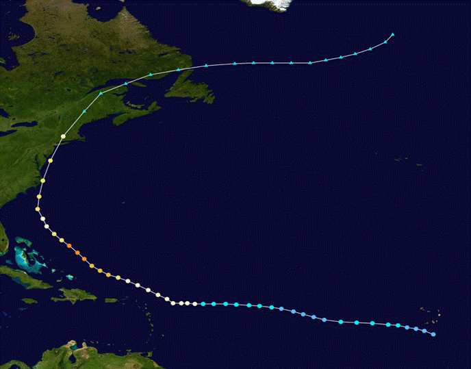
Figure 1. Track of Hurricane Gloria, September 15 through September 28, 1985.
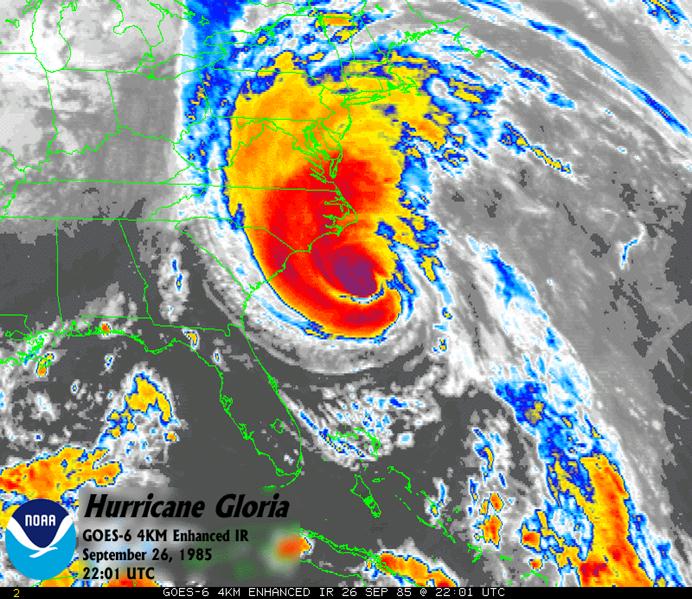
Figure 2. Satellite image of Hurricane Gloria just south of the Outer Banks on September 26, 1985.
Evolution and Impacts
Gloria began as a tropical wave that moved off the coast of Africa on September 15. It moved westward through the favorable tropical Atlantic Ocean, and organized into a tropical depression the next day while south of Cape Verde. Tracking steadily west-northwestward due to the strong subtropical ridge, the depression continued to strengthen and became Tropical Storm Gloria on the 17th. Conditions for tropical development deteriorated, causing Gloria to weaken to a tropical depression on the 18th. After it crossed 45°W on the 20th, the system was able to restrengthen to a tropical storm, and steadily intensified as it approached the Lesser Antilles. While 620 miles east-southeast of St. Croix, Gloria attained hurricane status.
While passing to the northeast of the Bahamas, Gloria strengthened significantly in very favorable conditions, reaching major hurricane status on the 24th and peak wind speeds of 145 mph and a central pressure of 919 millibars on the 25th. This is the second lowest pressure ever recorded in an Atlantic hurricane that never reached Category 5 status, only second to Hurricane Opal of the 1995 season. As Hurricane Gloria churned up the waters of the North Atlantic to its ultimate demise in the Canadian Maritimes, the media began to cover it as the “Storm of the Century”. Gloria led to the evacuation of 380,000 people along the coast from North Carolina to Connecticut. Upon making landfall on the Outer Banks, Gloria was a fast-moving hurricane that struck at low tide, reducing storm surges to a maximum of 6 feet in North Carolina. Strong winds did occur near the North Carolina coast. Diamond Shoals Light reported sustained winds of 100 mph, and Cape Hatteras, where the storm's eye came ashore, experienced 75 mph winds. Though Gloria moved quickly through the region, it dropped heavy rainfall in locations (Figure 3), including 7.09 inches in New Bern and over 9 inches at Edenton in Northeast North Carolina.
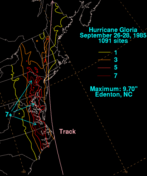
Figure 3. Rain totals from Hurricane Gloria.
Beach erosion and coastal flooding were severe along portions of the North Carolina Outer Banks. Considerable flooding also occurred in Pamlico Sound after the center passed. There was one death attributed to Gloria in North Carolina.
Sources
Wikipedia
National Hurricane Center
National Centers for Environmental Prediction
Damage Photos from the Outer Banks
Courtesy: Associated Press
Flooding at Cedar Island during Hurricane Gloria.

Massive Evacuations during Hurricane Gloria.
Case Study Team
Chris Collins


 Tropical Weather
 Map View
 Weather Hazard Briefing (when applicable)
 Forecaster Discussion
 Marine
 Text Products
.png) Skywarn
Skywarn Submit Storm Reports
 Coastal Flood