| A Review of Weather in 2002 |
The year 2002 had its share of interesting weather phenomena in Tallahassee and surrounding areas. Following are a few of the weather highlights that occurred in the NWS Tallahassee County Warning & Forecast Area in 2002.
Snow Flurries & Roller Coaster Winter Temps
As can be seen in Figure 1 (below), the year started out on a very cold note. The first week of 2002 saw the first snow flurries officially observed in Tallahassee since March 1996. Snow occurred twice on January 3rd. Large flakes fell briefly around 5:30 AM with several areas seeing small snow pellets during the late afternoon hours. Dothan, AL, and Albany and Valdosta, GA, also reported flurries that day. Another brief period of flurries occurred in Tallahassee on January 7th. Temperatures during the first nine days of the month averaged well below normal with subfreezing temperatures in Tallahassee on six of the first nine mornings. The low of 19 on the 5th broke the record for the date. A period of very mild weather commenced on January 18 and continued until February 1, when the mercury reached 80 degrees in Tallahassee and 83 in Valdosta. After a period of fairly normal winter weather, a late season arctic outbreak brought the coldest temperatures of the season to the region from February 27 through March 5. The low of 18 on the morning of the 28th was the coldest temperature of the year in Tallahassee, a record for the date. Albany recorded 18 that morning. Record lows were also recorded in Tallahassee on March 1st and 5th. The coldest afternoon of the year occurred on March 4th with a high temperature of just 41 degrees.
Very Warm Spring
The late season cold snap ended abruptly with the last freeze of the seaon in Tallahassee occurring on March 6th. Most of the Spring season averaged well above normal with April being the warmest on record in Tallahassee. Temperatures reached 80 or better on 12 of the last 17 days in March. The first 90 degree temperature of the season occurred April 18th and there were five other such days during the month. Nighttime lows were very mild. After the 7th, the temperature never fell below 57 degrees in April. The hot weather continued into May with twelve of the first 13 days exceeding 90 degrees. Record highs were tied on May 3rd and 9th. A brief cool period commenced on the 14th and continued to the 24th. The mercury dipped below 50 in Tallahassee on the 20th and 21st with a record low set on the 21st.
Typical Summer Temperatures
Temperatures were fairly typical during the summer months. Temperatures averaged about a half a degree cooler than average for the season. Hot spells occurred in early June and mid July, with the latter being the hottest of the season. The temperature reached 100 degrees on two consecutive days in July. On the 18th, the mercury officially reached 100 degrees at the Tallahassee airport for the first time since July 20, 2000. Both Albany and Apalachicola reached the century mark that day as well. The high of 101 in Tallahassee the next day was the hottest temperature of the year. Panama City FL, Dothan AL and Valdosta GA all reached 100 degrees that day as well. During the second weak of August, a front swept in the from the north bringing an unusual break from summer's typical unending humidity. The dry air allowed overnight temperatures to drop to comfortable levels on the 9th and 10th with record lows of 60 and 64 established respectively. The low of 60 on the 9th was the coolest ever recorded so early in the season. That morning saw the mercury dip to 58 in Valdosta, with record lows of 58 at Perry FL, 57 at Cross City FL, 62 at Albany and 69 at Apalachicola. No record high temperatures were set during the summer months.
Hot Early Autumn - Cold Late Autumn/Early Winter
Summer's heat continued into the early part of Autumn. Temperatures reached or exceeded 90 degrees on five of the first seven days in October. The record high of 94 on the 6th was just a degree shy of Tallahassee's all-time October maximum temperature of 95 set October 1, 1933. Apalachicola set a record high of 90 on the 13th. A brief cool spell occurred mid month with the only below normal days in Tallahassee occurring consecutively from the 15th through 19th. However, the lowest temperature recorded was just 46 degrees on the 18th and 19th. The month averaged nearly five degrees above normal. The warm weather continued into the second week of November with a record high of 86 recorded on the 11th. Apalachicola set a record high of 82 on that date. Wintery temperatures set in after that. The first official freeze occurred on the 18th with a low of 32 in Tallahassee and Albany, and 31 at Valdosta. The first widespread freeze occurred on the 23rd. There were a total of four mornings with temperatures at or below freezing for the month with the coldest temperature of the season in Tallahassee (25) setting a record for the date on the 29th. Apalachicola set a record that morning as well at 31 degrees, the first freeze of the season for that coastal city. The cold weather continued through most of December with a dozen days reaching the freezing mark or lower in Tallahassee. Overall, the two months averaged over three degrees colder than normal.
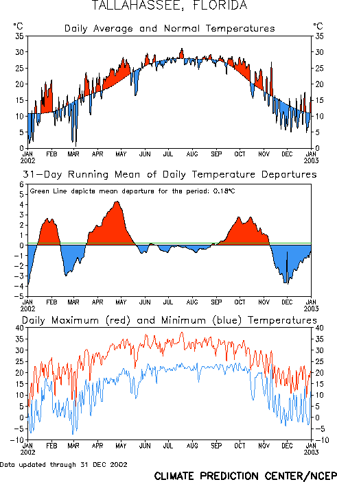
Figure 1. Temperatures in Tallahassee during the year 2002.
Rainfall Deficit Continues
After near normal precipitation in 2001, Tallahassee ran a rainfall deficit for most of 2002. As can be seen in Figure 2, with the exception of a single torrential rainstorm in early March (see discussion below), the rainfall deficit grew steadily through the first half of the year. Frequent rains occurred in January, but February precipitation was just 1/3 of normal. The period from April through June was quite dry, with only two significant rainfalls during that time. During the driest stretch, no measurable rain fell in Tallahassee from April 20 through May 17, a period of four weeks. By the end of June, the rainfall deficit was running about ten inches. The second half of the year had near normal rainfall on average. However, August was abnormally dry. The greatest deficit of the year was reached on September 11. Heavy rains associated with Tropical Storm Hanna drenched the area in mid September (see discussion below), and the remainder of the year saw near normal precipitation. The annual rainfall total in Tallahassee was 56.10 inches, which was 7.11 inches below the 1971-2000 normal.
Early March Flooding Across the Florida Big Bend
Heavy rains fell across the region on March 2nd and 3rd with nearly 8.5 inches of rain falling in Tallahassee in just 24 hours. Valdosta got nearly five inches from the same system, but much less rainfall occurred further north and east. Widespread flooding occurred across much of the Florida Big Bend and Eastern Panhandle. In Calhoun County, about 80 percent of the county's dirt roads were closed due to flooding. In Leon County, an estimated 90 homes sustained significant water damage. Several residences in the Carriage Estates mobile home park were evacuated due to high water. Numerous motorists were rescued from stranded vehicles. Many Tallahassee streets and county roads were closed. Similar flooding was reported in Wakulla, Jefferson and Madison counties.
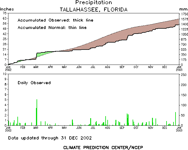
Figure 2. Rainfall in Tallahassee during the year 2002.
Tropical Storm Hanna
Tropical Storm Hanna passed over southeastern Louisiana near the mouth of the Mississippi River early on September 14th and made landfall near the Alabama-Mississippi border around midday with 50 mph winds. The strongest winds locally were observed at Cape San Blas, FL. At 4:00 AM EDT, the wind at the Cape was blowing out of the south at 41 mph, with gusts to 55 mph. Peak winds across inland portions of the Florida Big Bend and Eastern Panhandle were generally 30-35 mph. Wind damage occurred in Walton and Jackson Counties in the Panhandle, and Seminole County in Southwest Georgia. There was a four-foot storm surge in Walton County, with tidal departures of three and two feet in Bay and Gulf Counties, respectively. Dangerous rip currents were responsible for two deaths. Two adult men drowned, one near Seagrove Beach on the 14th, and the other at Panama City Beach on the 15th. The main impact from this storm on the local area was the flooding rains. Rainfall totals were generally 5 to 7 inches across the eastern Panhandle and western Big Bend in Florida, as well as across southwest Georgia. Two- to four-inch totals were common further north and east. The greatest rainfall from the storm anywhere in the U.S. occurred in Donalsonville, GA, which is in Seminole County in extreme southwest Georgia. Heavy rains kept training over this location and produced an incredible 15.56 inches of rain. This flooded numerous homes in the area, as well as U.S. Highway 84. Nearby Spring Creek crested above flood stage. Elsewhere, flooding occurred in adjacent areas of Jackson County, FL, and Miller County, GA, as well as in Perry, FL, and along the St. Mark's River. Fortunately, Hanna spawned no tornadoes in the area. Additional information on Tropical Storm Hanna can be found here.
Tropical Storm Isidore
On September 26, Tropical Storm Isidore made landfall well west of the area, along the Louisiana coast just west of Grand Isle. However, Isidore was a hybrid system and therefore displayed characteristics of both a tropical and extratropical system. The result was that the maximum winds and heaviest rains extended well away from the storm's center. Peak winds locally were even higher than those from Hanna. Because Isidore was a major hurricane while it skimmed the Yucatan Peninsula, large swells were generated which propagated north across the Gulf of Mexico. The combination of wind and wave action produced larger storm surge than would normally be expected with a tropical storm, along with some coastal flooding and severe beach erosion along the coast. Cape San Blas once again recorded the highest observed wind in our region. At 4:00 AM EDT, the wind was clocked at 46 mph out of the southeast with gusts to 58 mph. Most inland stations had peak winds of 30-40 mph. The buoys moored about 80-90 miles off the coast recorded peak seas of 19-24 feet. A 5-7 foot storm surge removed about 400, 000 cubic yards of sand from the Walton County coast, resulting in about $4 million dollars damage. A 5-foot surge removed even more sand from Bay County beaches. Storm surge of 3-4 feet also caused substantial beach erosion in Gulf, Franklin, and Wakulla Counties. On Dog Island, two houses partially collapsed and several others were damaged. Fortunately, there were no rip current deaths reported. Two tornadoes touched down in Walton County. One twister damaged several mobile homes in Santa Rosa Beach. Another tornado damaged numerous homes in Sandestin near U.S. Highway 98. Further inland, four homes were damaged in Graceville in Jackson County, FL. One person was injured there. At Bonifay in Holmes County, FL, there was damage to the roof and a school bus at Poplar Springs High School. The greatest rainfall total occurred in Geneva, AL, were 5.6 inches of rain fell. Most other areas got 1-3 inches. Additional information on Tropical Storm Isidore can be found here.
Severe Weather
Typically, this part of the country sees a peak in severe weather activity during the spring months with a secondary maximum in November. Through summer, isolated severe storms are possible on almost any day, although large outbreaks are much less common. Occasionally severe weather occurs in the winter months, and some of these can be major outbreaks. In 2002, there were several severe weather episodes during spring and above average activity in the fall. However, the biggest severe weather outbreak of the year occurred during a winter month. Monthly summaries of severe weather occurrences in 2002 can be obtained by clicking the links below.
January
The first severe weather outbreak of the year occurred on Saturday, January 19, and primarily affected southwest and south central Georgia, with a few reports in southeast Alabama as well. A few trees were blown down in Coffee and Houston counties in southeast Alabama. However, the bulk of the damage occurred further east. Damage was reported in ten different counties in southwest and south central Georgia. Downed trees and power lines accounted for most of the damage. However, the Terrell County EMA office reported roof damage to their own office in Dawson. High winds overturned a mobile home in Cooktown, GA. A house in Baconton, GA also sustained roof damage.
February
No severe weather was reported during the very dry month of February.
March
In March, there were two severe weather episodes. On the afternoon of Tuesday, the 12th, severe weather occurred across much of Alabama, Georgia and northern Florida, the second largest event of the year. Dime size hail was reported in Tallahassee, as well as near Bainbridge, GA, and near the coast in southwest Bay County, FL. In addition to downed trees and power lines, structural damage was reported in several areas. In Bayou George, FL, a double wide trailer was destroyed and a roof was blown off a house. In Jackson County, the roof was blown off a hangar at the Marianna Municipal Airport, destroying a nearby airplane. A building was destroyed in northeast Gulf County. Windows were blown out of a house in Perry, FL. In Valdosta, GA, two homes were damaged. Fortunately, there were no injuries or fatalities reported during this event. The second severe weather episode of the month occurred during the afternoon of Sunday, the 31st. In southeast Alabama, a tree fell onto a house in Dothan. In Wicksburg, a tree fell onto a barn and a shed was blown over. A roof was blown off a house in northeast Mitchell County, GA. In Moultrie, GA, an elderly man was killed when a pine tree snapped and fell on the cab of the truck he was driving during a severe thunderstorm.
April
Like March, there were two severe weather episodes in April. On Wednesday the 3rd, most of the storms were hailers. Ten counties in the region reported hail of at least dime size. The largest hailstones were reported in the Gadsden County town of Greensboro. The sheriff's office there estimated the hail to be as large as baseballs. In Georgia, golf ball size hail was reported in Decatur, Mitchell, Turner, and Ben Hill Counties. In Mitchell County, large hail damaged several vehicles and homes, and destroyed several strawberry and peach crops. Wind damage was quite limited in this event. The period Monday through Wednesday, April 28-30, was a stormy one across the southeastern U.S. However, the worst of the weather stayed north of the Tallahassee county warning area. On the 29th, gusty winds downed trees around Youngstown in Bay County, FL, while golf ball size hail was reported in Altha, FL. On the 30th, there were numerous reports of golf ball size hail in Abbeville, AL. In Georgia, a swath of nickel size hail was reported from Oak Hill to Morgan in Calhoun County, with trees and power lines downed in Cuthbert, Moultrie, and many parts of Baker County.
May
Severe weather occurred on three days in May. On Saturday the 11th, Geneva County, AL had a thunderstorm with damaging winds. In the city of Geneva itself, there was damage to the roofs of both an antique shop and a car dealership. Trees and power lines were felled across County Road 40. On the afternoon of Thursday May 30th, thunderstorms produced hail in Dale and Henry Counties in southeast Alabama. The largest hail, golf ball size, occurred along the county line 3 miles east of Echo. Trees were also blown down in these areas. In Florida, dime to nickel size hail fell in Tallahassee. Golf ball size hail was reported in Old Town, FL. In Madison County, several downed trees blocked traffic on Interstate 10. The next day, thunderstorm gusts downed trees in Taylor County, FL, and also in Dixie County at Horseshoe Beach. In Georgia, Dougherty County media and a SKYWARN spotter reported nickel size hail in Albany, GA. Wind gusts also downed trees, several large signs, and a small tower within the city limits. Dime size hail was reported in Fitzgerald, GA.
June
There were several instances of severe weather during the first half of June. On the afternoon of Saturday the 1st, thunderstorm gusts snapped a few large trees and blew down a utility pole in southeast Leon County, while golf ball size hail was reported in northern Wakulla County. Two days later, an NWS meteorologist observed quarter size hail in northern Tallahassee. Elsewhere in the city, hail was reported near the intersection of Old Bainbridge Rd. and I-10. In Liberty County, fallen trees downed power lines in Sumatra. That same day in Georgia, trees and power lines were downed in Ben Hill County with dime sized hail reported in Worth County. The next day, Tuesday June 4th, Leon County saw more hail storms. Dime size hail fell on State Highway 20 just west of Tallahassee, and in the city. Quarter size hail was reported in Quincy, FL. In Jackson County, FL, wind damage occurred in the Rocky Creek area. Large trees fell on three trailers, causing heavy damage. A church front awning and horse shed were destroyed. Several county roads were blocked by fallen trees. In Marianna, a portion of wall collapsed in a Jefferson Street business. In Georgia, nickel size hail fell on U.S. Highway 82 in Quitman County, while wind gusts downed trees in Terrell, Grady, Decatur and Mitchell counties. On Friday the 7th, some rural and county roads were flooded in Lee County, GA, when four inches of rain fell in two hours. On Friday June 14th, thunderstorm gusts blew trees down across Houston County, AL, including the city of Dothan. Elsewhere in the county, golf ball size hail fell in Pansey. In Georgia, dime size hail and downed trees were reported at a couple of locations in Miller County. Decatur County also sustained tree damage northwest of Bainbridge. In Florida, De Funiak Springs reported numerous downed power lines. On the 15th, a man drowned while attempting to escape a severe rip current at Panama City Beach. On the 20th, a few utility poles were uprooted by thunderstorm wind gusts in Apalachicola, FL.
July
In July and August, severe weather was more sporadic. On the afternoon and evening of Saturday July 6th, wind damage was reported in Turner and western Calhoun Counties in Georgia. Two days later, thunderstorm gusts downed trees and power lines near Natural Bridge, FL. On Friday the 19th, wind gusts knocked down several trees in Telogia, FL. One tree fell on a mobile home causing minor damage. On Saturday the 27th, thunderstorm gusts blew trees down 15 miles northeast of Bainbridge, GA.
August
On Thursday August 1st, trees and power lines came down in Albany in Dougherty County, GA, and in Brinson and Bainbridge, GA. On Tuesday the 20th, quarter size hail fell in Smithville, GA.
September
In September, the only severe weather that occurred was associated with Tropical Storms Hanna and Isidore (see discussion above).
October
There were several severe weather episodes during the autumn of 2002, most of them tornadic. On Tuesday October 29th, a couple of tornadoes touched down in southwest Georgia. One tornado downed trees near Vada. An hour later, a tornado destroyed a warehouse and knocked several trees and power lines down in Pelham, GA.
November
On Tuesday November 5th, three tornadoes touched down in the area. A tornado briefly touched down near Ponce De Leon, FL, on Interstate 10 causing a few car accidents. About an hour later, a tornado was sighted in far northeastern Dale County near Bertha, AL, at the intersection of County Route 69 and U.S. Highway 27. Two dwellings were damaged. This same tornado strengthened and turned deadly as it moved into Henry County as an F2. The twister swept east right through the heart of Abbeville at around 5:45 PM CST. One person was killed and 25 were injured. The high school and adjacent residential area, and many area businesses, sustained heavy damage. On Sunday November 10th, a waterspout moved ashore onto St. George Island in Franklin County, FL. It caused minor damage to an unoccupied beach house. The next day, the 11th, a late afternoon thunderstorm dumped quarter size hail 10 miles south of Colquitt, GA. Later that evening, a 60 mph wind gust was clocked in a thunderstorm at the Panama City-Bay County Airport. A bit later, dime size hail was reported in Norman Park, GA, in Colquitt County.
December
The next month and a half were relatively quiet. However, the biggest severe weather outbreak of the year occurred on Christmas Eve morning. Over a three hour period that morning, 32 severe weather reports were received at NWS Tallahassee. Several tornadoes developed out ahead of a squall line of thunderstorms that swept across the region between about 7:30 and 11:00 AM EST. In southeast Alabama, many trees and power lines were downed across the region. Possible tornado touchdowns were reported in Newton and Midland City in Dale County; Memphis Church and Columbia in Houston County; and in Headland, Tumbleton and Haleburg in Henry County. A mobile home was overturned in Memphis Church. Eight people were injured in Haleburg where one mobile home was destroyed and several other structures were heavily damaged. In the Florida Panhandle, straight line wind damage was reported across much of Washington and Holmes Counties. A waterspout was spotted out over the Gulf of Mexico, 18 miles south of Fort Walton Beach. Five minutes later, the waterspout was sighted near Grayton Beach in Walton County. Twenty five minutes after that, a possible tornado touchdown was reported by a spotter in the eastern part of the county in Red Bay. In Georgia, tornado reports were coming in for about an hour before the squall line took over and damaging straight line winds became the norm. The first tornado in this part of the state was the strongest of the morrning. At 8:20 AM EST, a tornado touched down in Early County,GA, two miles north of Blakely. Two people were injured when a home was destroyed. Two other homes sustained moderate damage with 25 residences receiving minor damage. In addition, 8-12 irrigation systems were overturned. At 8:45 AM, a tornado was reported by a SKYWARN spotter in Dougherty County in northwest Albany. Some trees fell onto houses and there were power outages. A half hour later, another twister menaced Albany. This one damaged 10 homes and an apartment complex. One person sustained minor injuries. Possible tornadoes were also reported in Calhoun County, where two mobile homes were destroyed, and in Southeast Terrell County. A tornado briefly touched down in the Worth County seat of Sylvester, damaging one house. Straight line winds damaged six homes in southwest Lee County and downed several trees and power lines. One home was damaged in Thomas County later that morning. Elsewhere, damage to trees and power lines occurred in Colquitt, Mitchell, Tift, Turner, Irwin, Ben Hill, Brooks, Berrien, Cook, Lanier and Lowndes counties. At Moody Air Force Base north of Valdosta, GA, the weather observer clocked a 63 mph gust when the squall line swept past.
Previous Years
Reviews of local weather in 2001 and 2000 are also available.
National Weather in 2002
An article summarizing last year's weather across the nation has been published by NOAA. A more detailed summary has been posted by NCDC. Also included in this site is a collection of significant weather events that occurred nationally last year.


 Follow us on YouTube