
Dangerous heat will build across the Southwest U.S. through the end of the week with daytime highs of 110-115°F. Isolated to widely scattered severe storms are expected across parts of the central and southern High Plains, Great Lakes into the Ohio Valley, and parts of the Ozarks to Lower Mississippi Valley today. Read More >
Albuquerque, NM
Weather Forecast Office
| Southern Desert |
| March-April-May Precipitation |
|
(Return to Main Feature) or go to CD1 | CD2 | CD3 | CD4 | CD5 | CD6 | CD7 |
|
Average precipitation in March-April-May is highest in the southwest and south central portion of the state, and it is here where increases (in terms of percent of normal) are generally highest in the state. During El Niño events, and especially strong events, spring precipitation can be much larger than normal. In Lordsburg, for example, spring precipitation in 1995 was almost four times that of the long term average. |
|
A description of the graphs is located at the bottom of the page. |
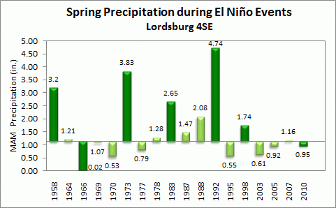 |
| Percent of Longterm Average for all El Niño Events = 143% , for strong El Niño Events = 218% |
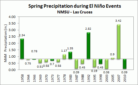 |
| Percent of Longterm Average for all El Niño Events = 118% , for strong El Niño Events = 150% |
|
Precipitation values for 3-month periods during 18 El Niño Events since 1949-1950 are plotted with respect to the long term precipitation average, listed to the right of the graph. The precipitation totals for each 3-month period are plotted above or below each bar. Years for which the El Niño Event was considered to be strong are colored in dark green. "M" represents a 3-month period with missing data. Finally, the percents of long term normal for all El Niño events and for the strong El Niño events are listed below each graph. |
Current Hazards
Outlooks
Submit A Storm Report
Severe and Hazardous Weather Info
Current Conditions
Surface Observations
Observed Precipitation
Satellite
Local Satellite Page
Local Observations Page
Map of Latest Wind and Precipitation Reports
Radar
National Radar
ABX Albuquerque Radar
FDX Cannon Air Force Base Radar
Forecasts
Fire Weather Forecasts
Area Forecast Discussion
Hourly View Forecast
Activity Planner
Aviation Forecasts
Local Forecast Page
Graphical Forecasts
Hydrology
Local Hydrology Products
Advanced Hydrologic Prediction Services
Climate and Past Weather
Winter Climatology for NM
NOAA Climate Center
Climate Prediction Center
Climate Graphs
Drought
Severe T-Storm Climatology for NM
Local Data
Local Programs
About Our Office
SKYWARN
NOAA Weather Radio
Local Studies and Features
Winter Weather Info, Safety Tips, and Climo
Severe Weather Info, Safety Tips, and Climo
Center Weather Service Unit

US Dept of Commerce
National Oceanic and Atmospheric Administration
National Weather Service
Albuquerque, NM
2341 Clark Carr Loop SE
Albuquerque, NM 87106-5633
(505) 243-0702
Comments? Questions? Please Contact Us.


 Follow us on X
 Follow us on Facebook
 Follow us on YouTube
 ABQ RSS Feed