
Dangerous and extreme heat will remain across portions of the southern U.S. this week. Heavy rainfall may bring significant flash flooding across portions of the Mid-Atlantic and Northeast through the night, and additional flash flooding concerns across New England on Wednesday. Monsoonal thunderstorms will bring a flash flood risk to the Four Corners region, especially in burn scar areas Read More >
| Wildland Fire Situation Reports - Updated Daily | ||||||||||||||||||
| National Report (pdf) | SWCC Morning Intelligence Briefing | Current Large Incidents | ||||||||||||||||||
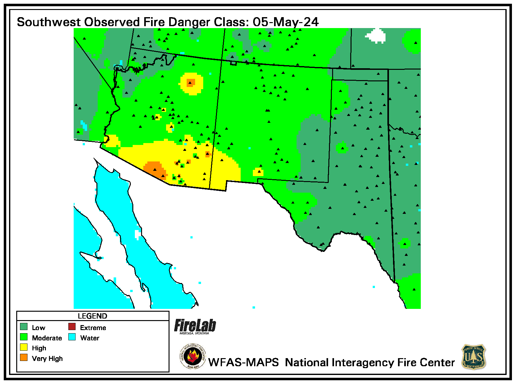
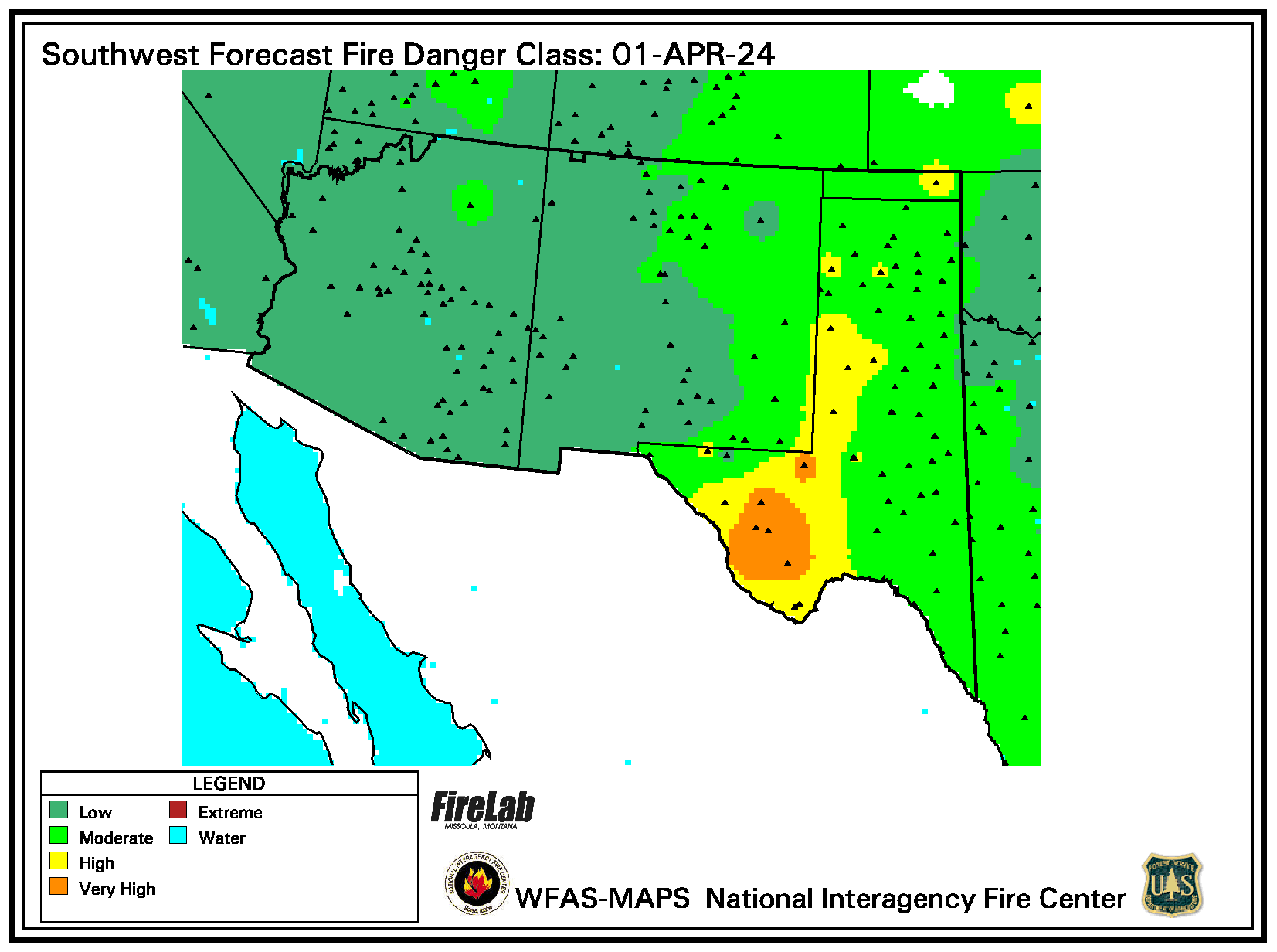
| Wildland Fire Assessment System (WFAS) - National maps of selected fire weather and fire danger components of the National Fire Danger Rating System (NFDRS). Also has maps of Keetch-Byram and Palmer drought indices. | ||||||||||||||||||
| MODIS Satellite Fire Detection - From USDA Forest Service (USFS) Remote Sensing Applications Center in cooperation with NASA Goddard Space Flight Center, the University of Maryland, the National Interagency Fire Center, and the USFS Missoula Fire Sciences Lab. | ||||||||||||||||||
| Fire Danger and Potential Graphics from WFAS - Updated Each Evening | ||||||||||||||||||
| Note: Forecasts may not depict accurate fire danger between October and April. | ||||||||||||||||||
| Large Fire Potential Index | ||||||||||||||||||
| * The experimental fire potential index map uses satellite derived Relative Greenness, an NFDRS fuel model map (both 1 km resolution), and an interpolated 10-hour time-lag map as inputs to weight the relative influence of live and dead vegetation to fire potential. The scale ranges from 0 (low) to 100 (high). | ||||||||||||||||||
| Dead Fuel Moisture - Updated Each Evening | ||||||||||||||||||
| 10 hour | 1/4 to 1 inch | |||||||||||||||||
| 100 hour | 1 to 3 inches | |||||||||||||||||
| 1000 hour | greater then 3 inches | |||||||||||||||||
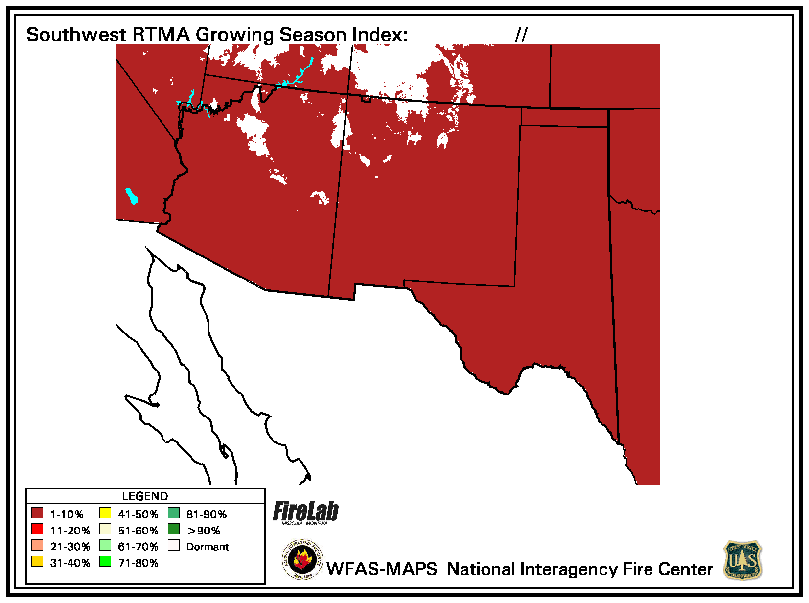
| Southwest Growing Season Index (WFAS-MAPS NIFC) | ||||||||||||||||||
| Graphical (Phenology Monitoring System) (Values greater than 50 suggests green up.) | ||||||||||||||||||
| Energy Release Component (ERC)- The Energy Release Component is a number related to the available energy (BTU) per unit area (square foot) within the flaming front at the head of a fire. The computation falls out of the National Fire Danger Rating System (NFDRS). Daily variations in ERC are due to changes in moisture content of the various fuels present, both live and dead. Since this number represents the potential "heat release" per unit area in the flaming zone, it can provide guidance to several important fire activities. It may also be considered a composite fuel moisture value as it reflects the contribution that all live and dead fuels have to potential fire intensity. The ERC is a cumulative or "build-up" type of index. As live fuels cure and dead fuels dry, the ERC values get higher thus providing a good reflection of drought conditions. The scale is open-ended or unlimited and, as with other NFDRS components, is relative. Conditions producing an ERC value of 24 represent a potential heat release twice that of conditions resulting in an ERC value of 12. ERC is very comparable to the Build Up Index computed from the Canadian Forest Fire Danger Rating System (CFFDRS). | ||||||||||||||||||
| Southwest Region | ||||||||||||||||||
|
Soil Moisture- Soil moisture is a good proxy for determining near ground level fuel dryness. Especially where and when fuel dryness data does not exist. |
||||||||||||||||||
|
NASA SPoRT hosts land information system (LIS) data. Relative soil moisture (RSM) 0 to 10 cm data has correlated fairly well with large fire growth, especially values below 25% in open-grassland fuel environments and below 35% closed canopy-forested mountain environments. |
||||||||||||||||||

