
Widespread life-threatening flash and urban flooding continues in south-central Texas, with considerable flooding impacts possible across central Texas. Wildfire smoke is impacting air quality across much of the Great Lakes region into southern New England and the Mid-Atlantic. Monsoonal thunderstorms may produce isolated to scattered flash flooding across the Southwest into the Great Basin. Read More >
Overview
|
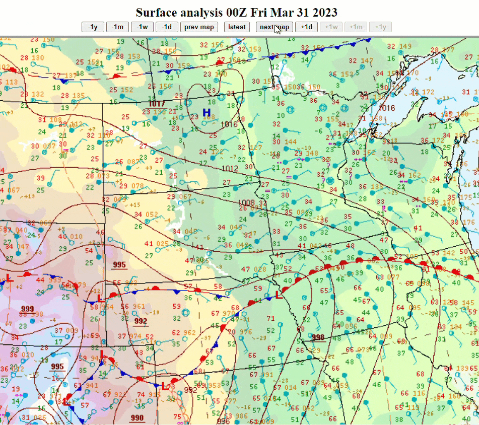
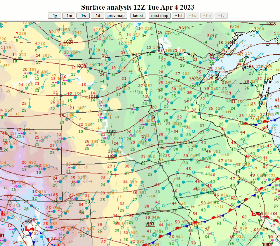
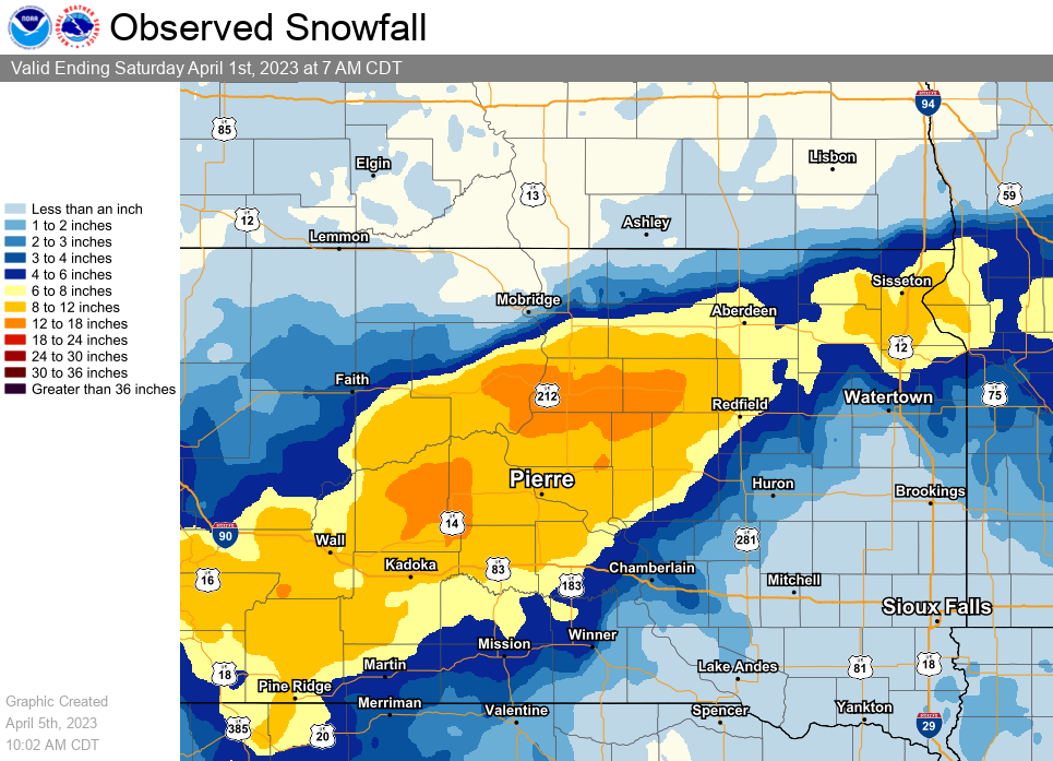
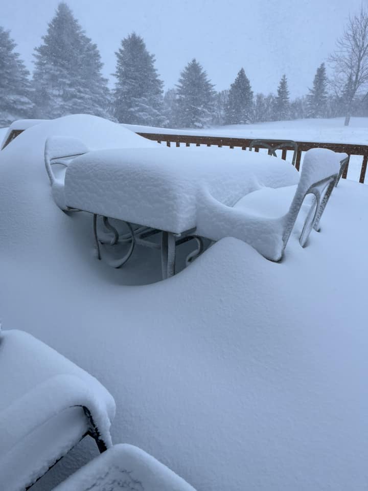
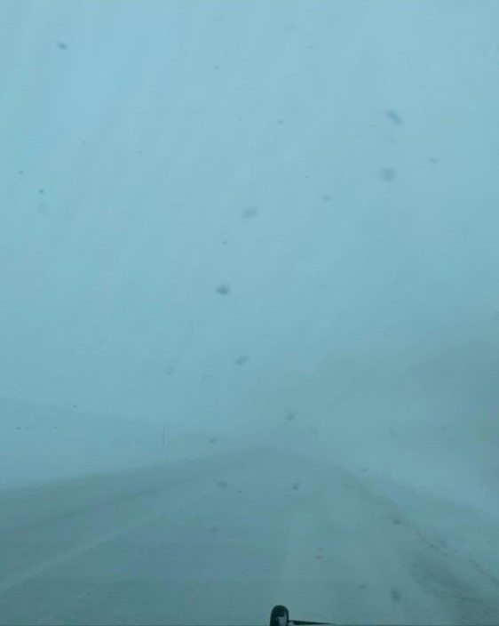
Two strong winter storms moved through the Dakotas during late March and early April 2023, bringing with them heavy snow, icing in eastern SD and western MN, along with gusty winds. They were both tied to a "Colorado Low", which is a low pressure system that develops east of the Rockies in Colorado and then moves through the Plains and into the Upper Mississippi Valley. While the process that created the storms was similar, there were differences in how each storm evolved. The March 31st storm had the heavy snow falling over central and northeast SD (amounts over a foot in a corridor between Pierre and Ipswich) while there were winds gusting to 40 to 55 mph. This produced blizzard conditions over much of central and northeast SD during the day and evening on March 31st. In addition, ice accumulations of over a quarter of an inch were reported in Grant, Codington, and Deuel counties. The April 4-5th event on the other hand had the heavy snow falling on April 4th over central and northeast SD, with northeast winds of 15-30mph. The combination of the snow and the winds led to visibilities being frequently reduced below a mile and at times down to a quarter mile in central and northeast SD. Meanwhile, the initial snow over east central SD transitioned to freezing rain for a period of time during the late afternoon and evening hours before switching back to snow. As the snow came to an end on April 5th, the winds shifted around to the west-northeast and with gusts of 30-45 mph, led to blowing and drifting of the new snow. These two storms capped off an already snowy winter season. Such late-season abnormal cold and snow also set the stage for significant spring flooding for parts of northeastern South Dakota and west central Minnesota. |
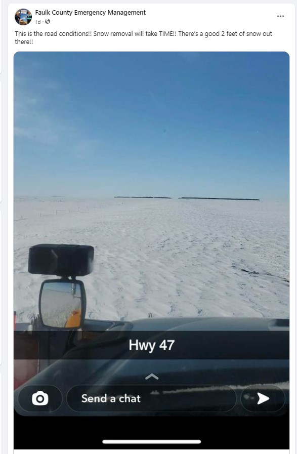 View of Highway 47 in Faulk County after the March 31 event (Image from Faulk County EM) |
 |
 |
 |
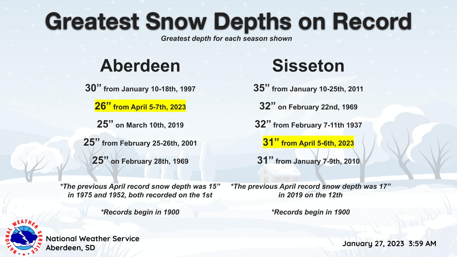 |
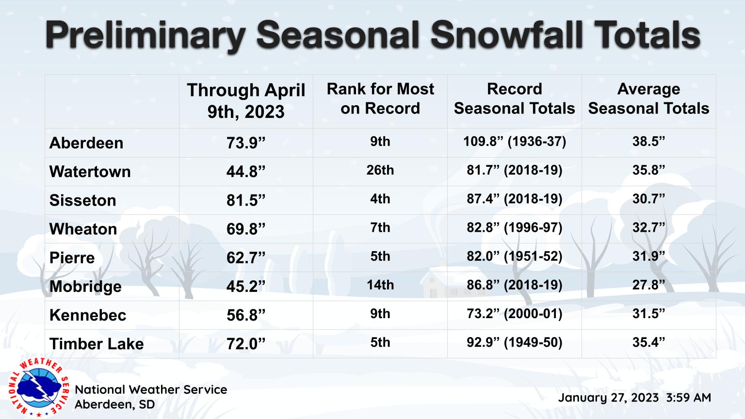
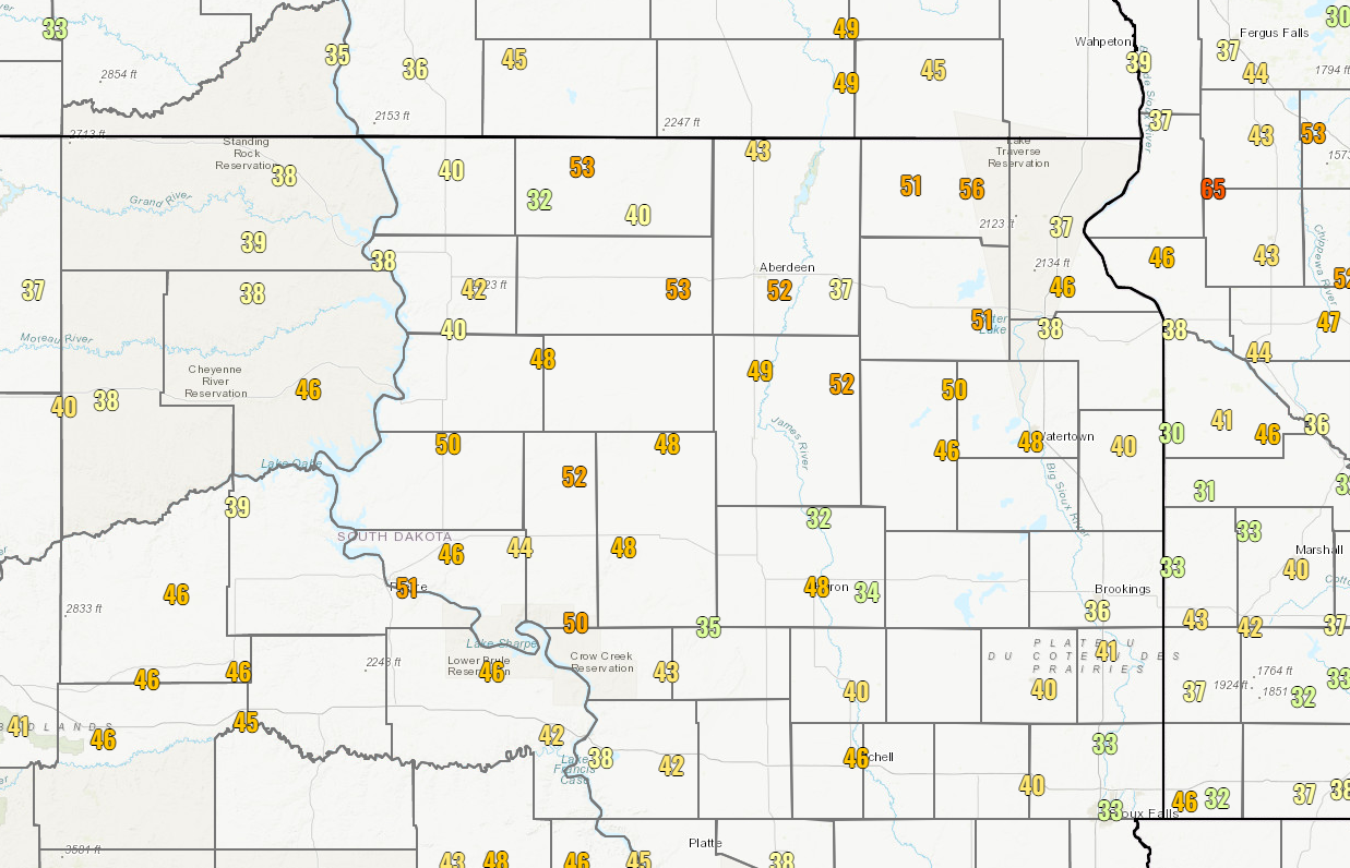
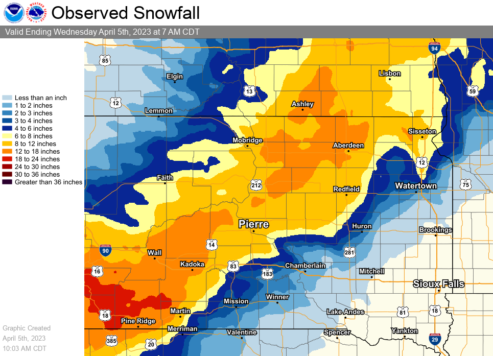
| Surface weather map for the March 31, 2023 Event | Surface weather map for the April 4-5, 2023 Event | Seasonal snowfall totals as of April 9th, 2023 | Snow depths across places such as Aberdeen and Sisseton were unprecedented for April. |
 |
 |
||
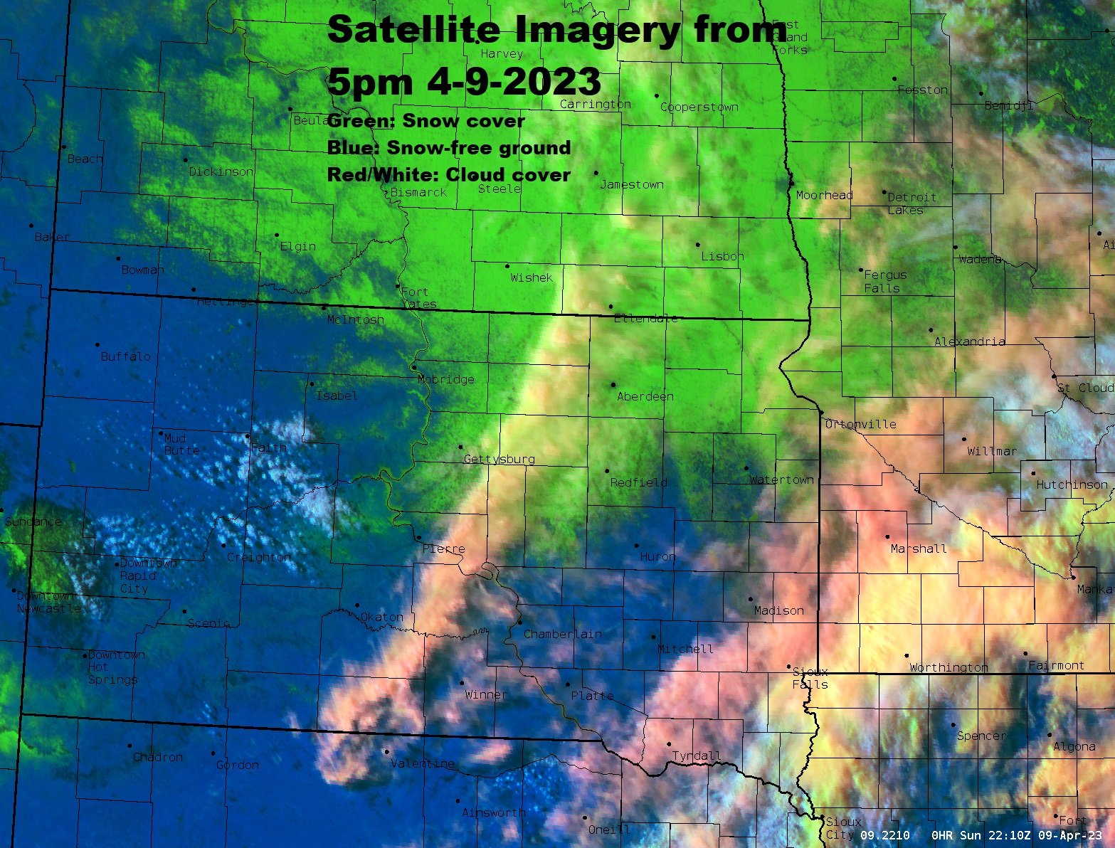
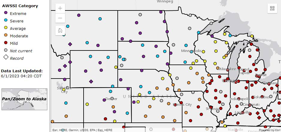
| Satellite imagery on April 9th shows plenty of snow yet in place, as a quick melt continued. | The 2022-2023 winter season finished Severe to Extreme according to the Accumulated Winter Season Severity Index. |
March 31 Snow/Ice/Blizzard
Event Snowfall - March 31st, 2023
Peak Wind Gusts on March 31st (in mph)
List of snowfall, ice, and Blizzard reports
PRELIMINARY LOCAL STORM REPORT...SUMMARY
NATIONAL WEATHER SERVICE ABERDEEN SD
1148 PM CDT SAT APR 1 2023

..TIME...   ...EVENT...      ...CITY LOCATION...     ...LAT.LON...
..DATE...   ....MAG....      ..COUNTY LOCATION..ST.. ...SOURCE....
            ..REMARKS..

0700 AM     SNOW             5 NNW MIRANDA           45.03N 99.00W
04/01/2023  M18.0 INCH       FAULK              SD   COCORAHS


0157 PM     HEAVY SNOW       7 E HAYES               44.37N 100.89W
04/01/2023  M16.0 INCH       STANLEY            SD   TRAINED SPOTTER

            STORM TOTAL.

0700 AM     HEAVY SNOW       8 SSW HIGHMORE          44.41N 99.50W
04/01/2023  M15.0 INCH       HYDE               SD   COCORAHS


0700 AM     HEAVY SNOW       17 N HOLABIRD           44.77N 99.59W
04/01/2023  M15.0 INCH       HYDE               SD   COCORAHS


1100 PM     HEAVY SNOW       HIGHMORE                44.52N 99.44W
03/31/2023  M14.2 INCH       HYDE               SD   PUBLIC

            RELAYED THROUGH TWITTER. END TIME ESTIMATED.

1100 PM     HEAVY SNOW       WILMOT                  45.41N 96.86W
03/31/2023  E14.0 INCH       ROBERTS            SD   PUBLIC


1150 PM     HEAVY SNOW       1 NW PIERRE             44.37N 100.35W
03/31/2023  M14.0 INCH       HUGHES             SD   PUBLIC


0509 AM     HEAVY SNOW       CRESBARD                45.17N 98.95W
04/01/2023  E14.0 INCH       FAULK              SD   PUBLIC

            SNOW ACCUMULATION ESTIMATED BETWEEN 12 AND
            16 INCHES.

1138 AM     HEAVY SNOW       FAULKTON                45.04N 99.13W
04/01/2023  M14.0 INCH       FAULK              SD   CO-OP OBSERVER


0900 PM     HEAVY SNOW       ONIDA                   44.70N 100.07W
03/31/2023  M13.0 INCH       SULLY              SD   PUBLIC


1100 PM     HEAVY SNOW       4 SE ANDOVER            45.37N 97.84W
03/31/2023  M12.5 INCH       DAY                SD   PUBLIC


0900 PM     HEAVY SNOW       GROTON                  45.45N 98.10W
03/31/2023  E12.0 INCH       BROWN              SD   PUBLIC


1100 PM     HEAVY SNOW       TOLSTOY                 45.21N 99.61W
03/31/2023  E12.0 INCH       POTTER             SD   PUBLIC

            RELAYED THROUGH TWITTER.

0257 PM     HEAVY SNOW       1 S CHELSEA             45.16N 98.74W
04/01/2023  M12.0 INCH       FAULK              SD   TRAINED SPOTTER


0845 PM     HEAVY SNOW       3 ESE CLAIRE CITY       45.84N 97.05W
03/31/2023  M11.5 INCH       ROBERTS            SD   PUBLIC


1102 PM     HEAVY SNOW       2 ENE HILLHEAD          45.84N 97.35W
03/31/2023  M11.2 INCH       MARSHALL           SD   PUBLIC


1100 PM     HEAVY SNOW       PIERRE                  44.37N 100.35W
03/31/2023  E11.0 INCH       HUGHES             SD   PUBLIC


0300 AM     HEAVY SNOW       REDFIELD                44.87N 98.52W
04/01/2023  E11.0 INCH       SPINK              SD   PUBLIC


0700 AM     HEAVY SNOW       3 W GRENVILLE           45.47N 97.44W
04/01/2023  M11.0 INCH       DAY                SD   COCORAHS


1138 PM     SNOW             11 ENE SISSETON MUNICIP 45.70N 96.77W
03/31/2023  M10.5 INCH       ROBERTS            SD   PUBLIC


0930 PM     HEAVY SNOW       1 NNW ABERDEEN          45.48N 98.49W
03/31/2023  M10.0 INCH       BROWN              SD   PUBLIC


0100 AM     HEAVY SNOW       MANSFIELD               45.24N 98.56W
04/01/2023  E10.0 INCH       SPINK              SD   PUBLIC

            DRIFTS TO 4 FEET.

0600 AM     HEAVY SNOW       4 W CHELSEA             45.17N 98.82W
04/01/2023  M10.0 INCH       FAULK              SD   COCORAHS


0849 AM     HEAVY SNOW       1 NE PIERRE REGIONAL AI 44.39N 100.29W
04/01/2023  M10.0 INCH       HUGHES             SD   CO-OP OBSERVER


0300 PM     HEAVY SNOW       3 W OKATON              43.89N 100.95W
03/31/2023  M9.0 INCH        JONES              SD   COCORAHS

            MEASURED BEFORE WINDS PICKED UP.

0719 AM     HEAVY SNOW       1 NNE BROWNS VALLEY     45.60N 96.83W
04/01/2023  M9.0 INCH        TRAVERSE           MN   CO-OP OBSERVER


1232 PM     HEAVY SNOW       ANDOVER                 45.42N 97.90W
04/01/2023  M9.0 INCH        DAY                SD   CO-OP OBSERVER


1000 PM     SNOW             SISSETON MUNICIPAL AIRP 45.67N 97.00W
03/31/2023  M8.6 INCH        ROBERTS            SD   CO-OP OBSERVER

            CO-OP OBSERVER STATION SSSS2 SISSETON 2 E.

0828 AM     HEAVY SNOW       ROSCOE                  45.45N 99.34W
04/01/2023  M7.7 INCH        EDMUNDS            SD   CO-OP OBSERVER


1102 AM     SNOW             ORTONVILLE              45.30N 96.44W
04/01/2023  M7.5 INCH        BIG STONE          MN   PUBLIC


0808 AM     HEAVY SNOW       3 NNW WESTPORT          45.69N 98.53W
04/01/2023  M7.5 INCH        BROWN              SD   CO-OP OBSERVER


0918 AM     HEAVY SNOW       ABERDEEN REGIONAL AIRPO 45.46N 98.41W
04/01/2023  E7.5 INCH        BROWN              SD   OFFICIAL NWS OBS


1049 AM     HEAVY SNOW       MURDO                   43.89N 100.71W
04/01/2023  M7.3 INCH        JONES              SD   CO-OP OBSERVER


1000 PM     HEAVY SNOW       VICTOR                  45.87N 96.84W
03/31/2023  M7.0 INCH        ROBERTS            SD   PUBLIC


1021 AM     HEAVY SNOW       1 NE MILBANK            45.23N 96.62W
04/01/2023  M7.0 INCH        GRANT              SD   CO-OP OBSERVER


0727 AM     HEAVY SNOW       BRITTON                 45.80N 97.75W
04/01/2023  M6.8 INCH        MARSHALL           SD   CO-OP OBSERVER


1048 AM     HEAVY SNOW       ROY LAKE STATE PARK     45.71N 97.44W
04/01/2023  M6.5 INCH        MARSHALL           SD   CO-OP OBSERVER


0900 PM     HEAVY SNOW       BROWNS VALLEY           45.59N 96.83W
03/31/2023  M6.0 INCH        TRAVERSE           MN   PUBLIC


0700 AM     HEAVY SNOW       9 N VIVIAN              44.05N 100.26W
04/01/2023  M6.0 INCH        LYMAN              SD   COCORAHS


0700 AM     SNOW             TURTON                  45.05N 98.10W
04/01/2023  M5.5 INCH        SPINK              SD   COCORAHS


0700 AM     SNOW             7 S VAYLAND             44.39N 98.80W
04/01/2023  M5.3 INCH        HAND               SD   COCORAHS


0700 AM     SNOW             LA BOLT                 45.05N 96.67W
04/01/2023  M5.2 INCH        GRANT              SD   COCORAHS


0700 AM     SNOW             2 SSE CLAREMONT         45.64N 98.00W
04/01/2023  M5.2 INCH        BROWN              SD   COCORAHS


0700 AM     SNOW             6 NE ROSCOE             45.51N 99.25W
04/01/2023  M5.0 INCH        EDMUNDS            SD   COCORAHS


0900 AM     SNOW             2 NNW EAGLE BUTTE       45.03N 101.26W
04/01/2023  M5.0 INCH        DEWEY              SD   COCORAHS


0924 AM     SNOW             WEBSTER                 45.34N 97.52W
04/01/2023  M5.0 INCH        DAY                SD   CO-OP OBSERVER


1023 AM     SNOW             CLARK                   44.88N 97.73W
04/01/2023  M3.1 INCH        CLARK              SD   CO-OP OBSERVER


1208 PM     SNOW             ONIDA                   44.70N 100.07W
03/31/2023  E3.0 INCH        SULLY              SD   PUBLIC

            STILL SNOWING. LOW VISIBILITY AS WELL.

0700 AM     SNOW             4 NNE RELIANCE          43.93N 99.57W
04/01/2023  M3.0 INCH        LYMAN              SD   COCORAHS


0700 AM     SNOW             4 WNW LAKE COCHRANE REC 44.73N 96.54W
04/01/2023  M2.6 INCH        DEUEL              SD   PUBLIC


1139 AM     SNOW             3 NNE GANN VALLEY       44.08N 98.97W
04/01/2023  M2.6 INCH        BUFFALO            SD   CO-OP OBSERVER


0900 AM     SNOW             MURDO                   43.88N 100.72W
03/31/2023  M2.4 INCH        JONES              SD   CO-OP OBSERVER

            CO-OP OBSERVER STATION MURS2 MURDO. STILL
            SNOWING.

0500 PM     ICE STORM        4 S STRANDBURG          44.99N 96.76W
03/31/2023                   GRANT              SD   PUBLIC

            PHOTOS OF 1/3 INCH OF ICE VIA FACEBOOK. TIME
            ESTIMATED.

1000 PM     ICE STORM        3 S BRANDT              44.62N 96.63W
03/31/2023                   DEUEL              SD   EMERGENCY MNGR

            CORRECTS TO ADD ADDITIONAL NOTES. 1/2 TO 3/4
            INCH ICE ACCUMULATION. RAIN TURNED TO SNOW
            AROUND 10:30 PM FRIDAY NIGHT.

0637 AM     ICE STORM        WATERTOWN               44.90N 97.10W
04/01/2023                   CODINGTON          SD   CO-OP OBSERVER

            1/4 INCH OF ICE UNDER THE SNOW.

0230 PM     BLIZZARD         2 N HOVEN               45.27N 99.78W
03/31/2023                   WALWORTH           SD   PUBLIC

            LESS THAN ONE QUARTER MILE VISIBILITY AND
            HEAVY SNOW. REPORTER COULD NOT SEE MORE THAN
            A FEW YARDS.

0854 PM     BLIZZARD         ORTONVILLE              45.30N 96.44W
03/31/2023                   BIG STONE          MN   PUBLIC


0855 PM     BLIZZARD         FLORENCE                45.06N 97.33W
03/31/2023                   CODINGTON          SD   PUBLIC

            VIDEO VIA FACEBOOK.

0900 PM     BLIZZARD         EUREKA                  45.77N 99.62W
03/31/2023                   MCPHERSON          SD   COCORAHS

            COCORAHS COMMENTED ON GROUND BLIZZARD
            CONDITIONS DESPITE LACK OF SNOWFALL. ROADS
            BLOCKED IN OPEN AREAS.

0900 PM     BLIZZARD         HIGHMORE                44.52N 99.44W
03/31/2023                   HYDE               SD   PUBLIC

            RELAYED PHOTOS THROUGH FACEBOOK.

1000 PM     BLIZZARD         LAKE CITY               45.72N 97.41W
03/31/2023                   MARSHALL           SD   PUBLIC

            RELAYED VIDEO THROUGH FACEBOOK. TIME
            ESTIMATED.

1000 PM     BLIZZARD         ABERDEEN REGIONAL AIRPO 45.46N 98.41W
03/31/2023                   BROWN              SD   OFFICIAL NWS OBS

            1/4 MILE OR LESS VISIBILITY FOR MORE THAN
            THREE HOURS FRIDAY AFTERNOON (KABR ASOS).
            STORM TOTAL SNOW WAS 7.5 INCHES.

1027 PM     BLIZZARD         REDFIELD                44.87N 98.52W
03/31/2023                   SPINK              SD   PUBLIC

            MESSAGE BLIZZARD CONDITIONS ON FACEBOOK.

1037 PM     BLIZZARD         MILLER                  44.52N 98.99W
03/31/2023                   HAND               SD   PUBLIC

            VIDEO RELAYED THROUGH FACEBOOK.

0716 AM     BLIZZARD         3 W SISSETON            45.66N 97.11W
04/01/2023                   ROBERTS            SD   CO-OP OBSERVER

            8.6 INCHES.


&&
March 31 Photos
 |
 |
 |
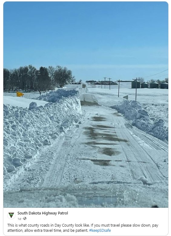 |
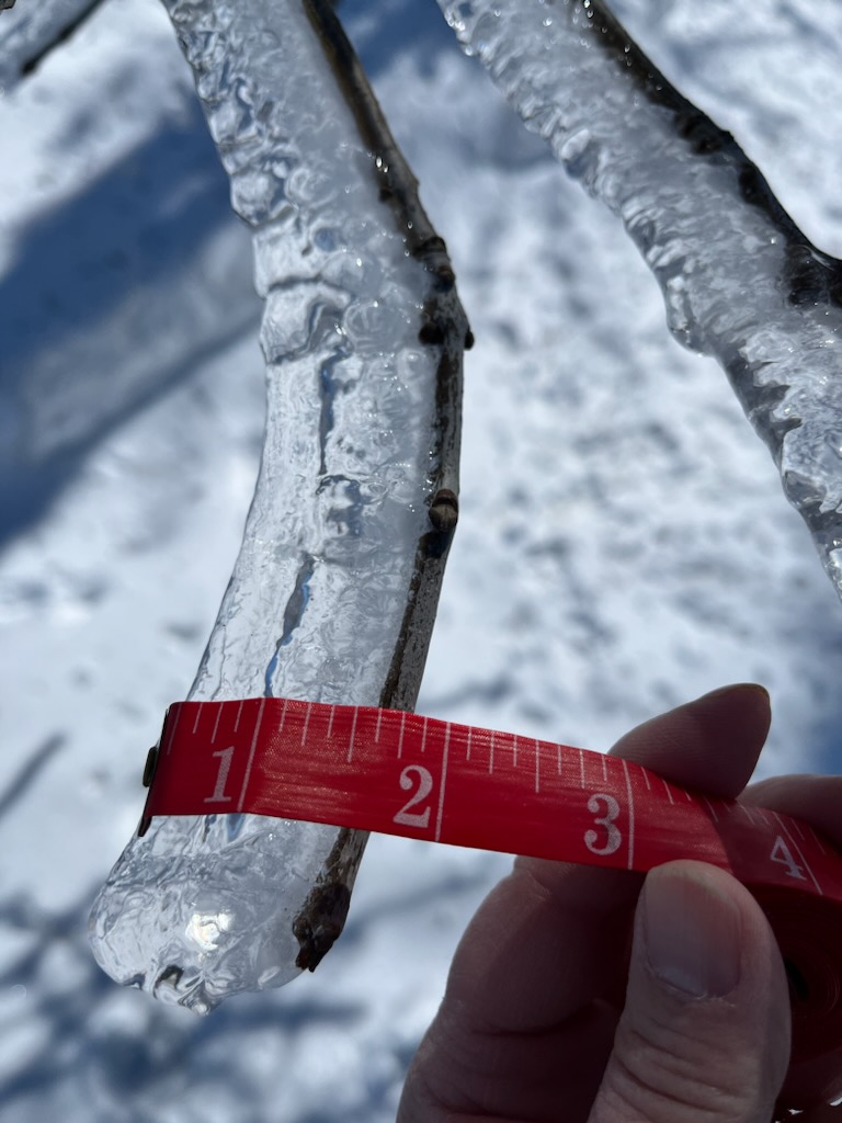
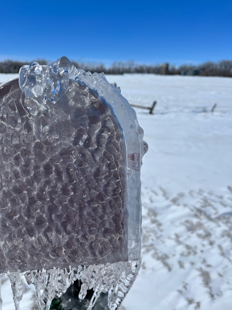
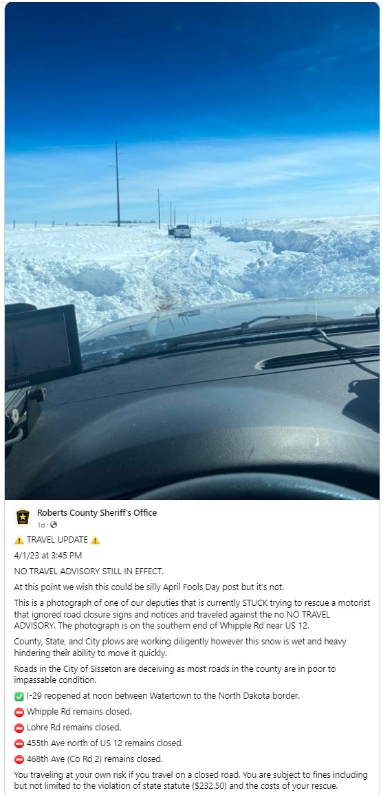
| Ice accumulation on a tree branch near Brandt, SD (Deuel County EM) | Ice accumulation on a mailbox near Brandt, SD (Deuel County EM) | Travel conditions the day after the March 31 event in Roberts County (Roberts County Sheriff's Office) | Travel conditions the day after the March 31 event in Day County (SD Highway Patrol) |
 |
 |
 |
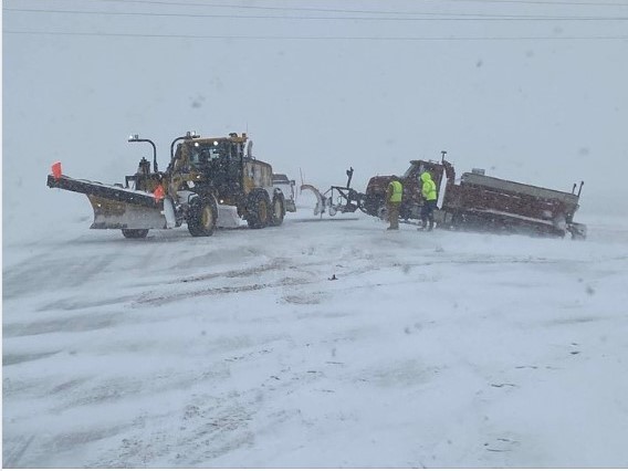 |
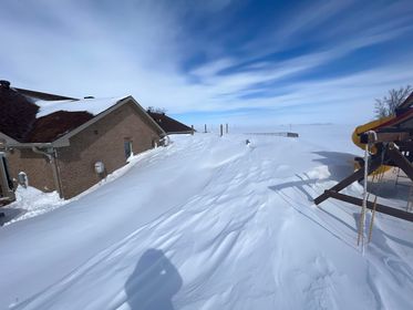
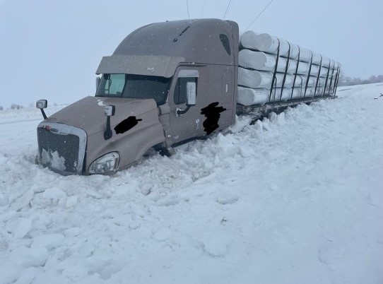
| Saturday morning in Faulkton (Faulk County EM) | Photo courtesy of the Hand County Sheriff's Office | Photo courtesy of the Hand County Sheriff's Office | Long day for county snow crews (Hughes County Sheriff's Office) |
 |
 |
 |
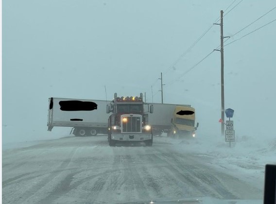 |
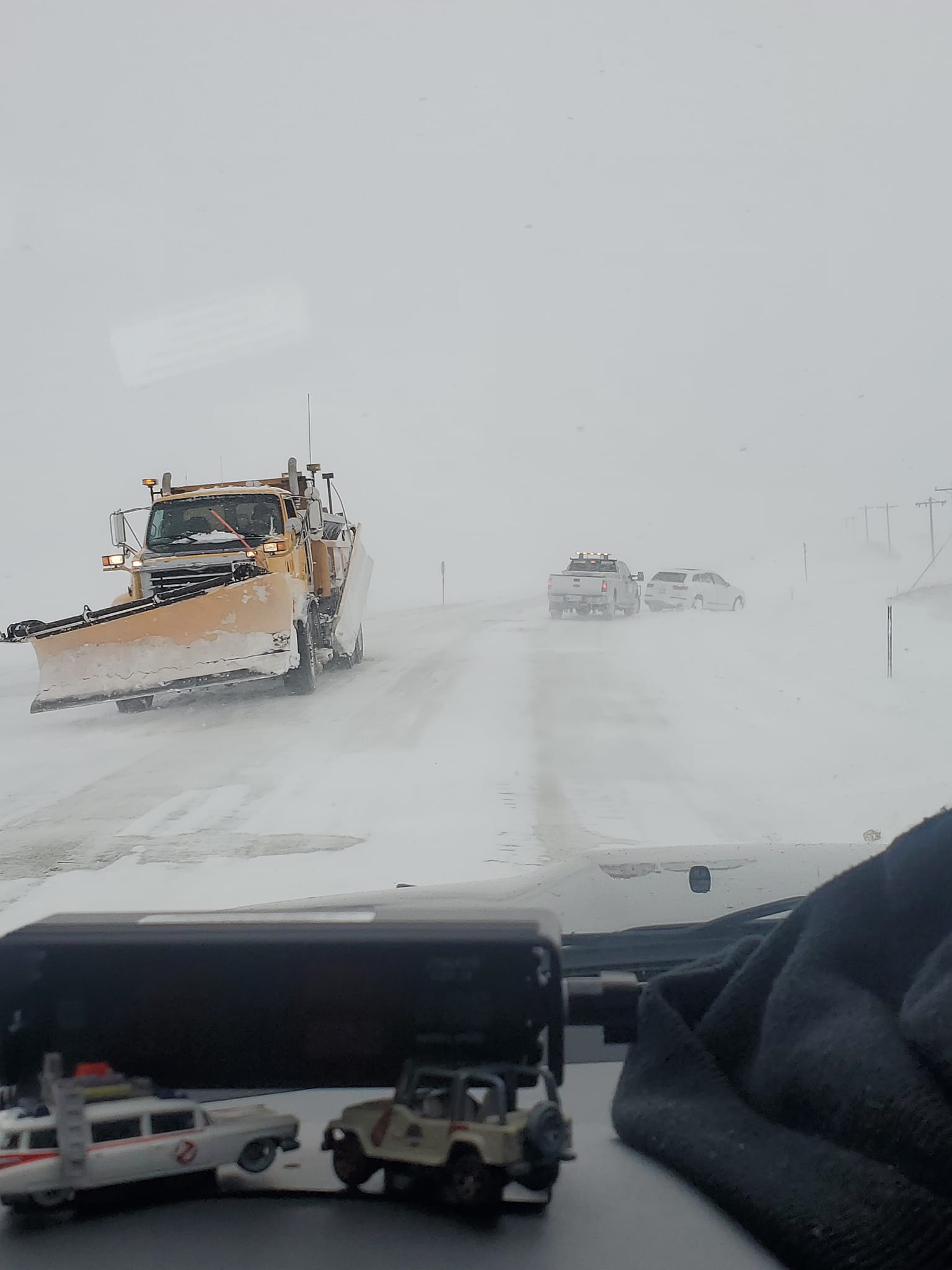
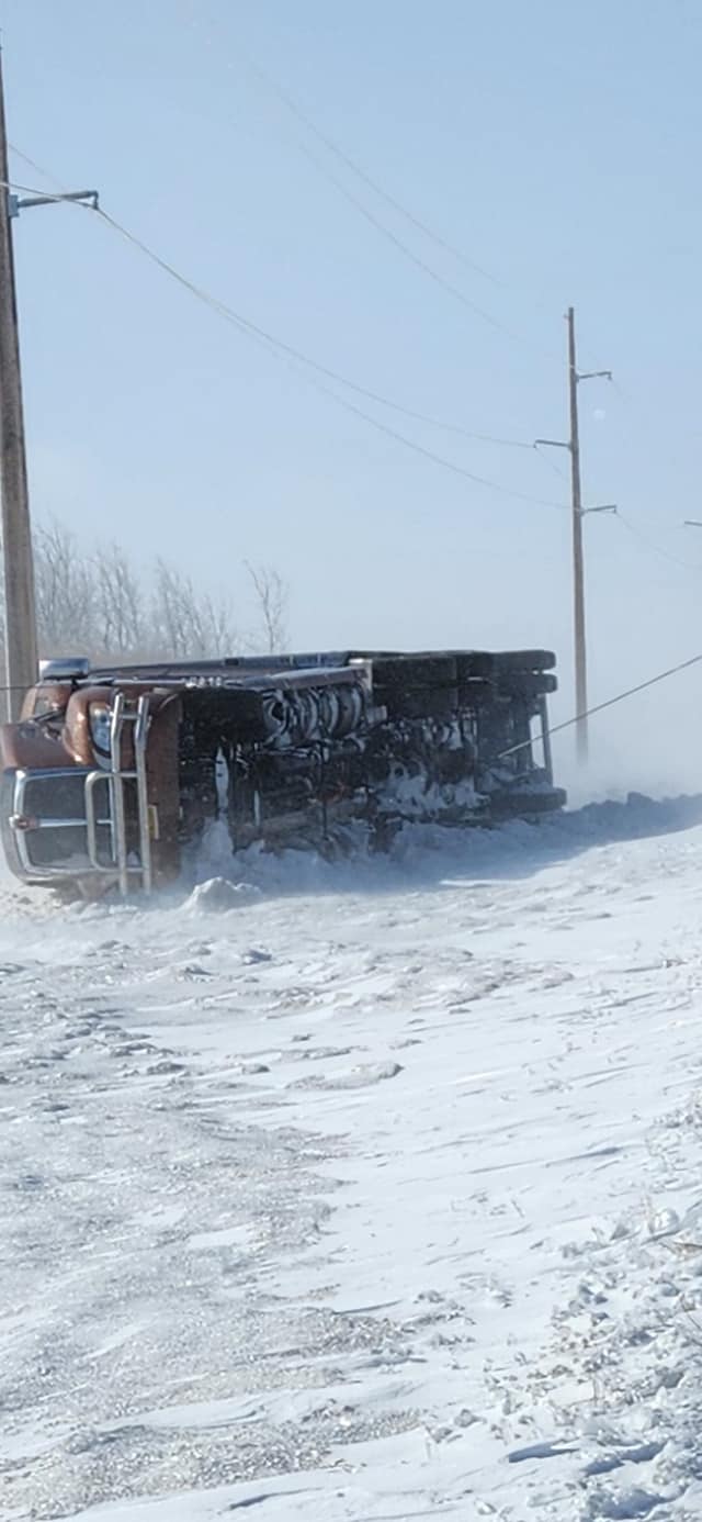
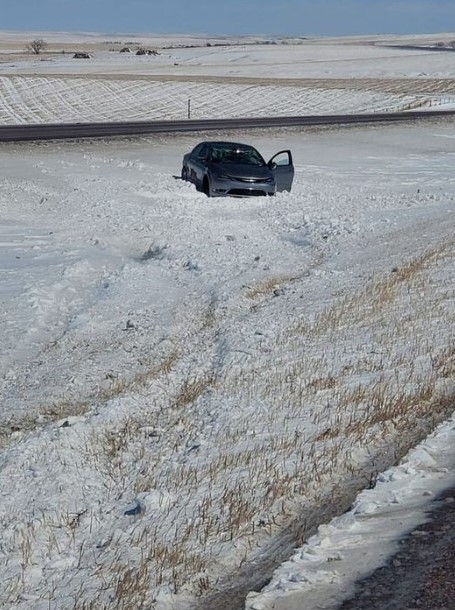
| Photo courtesy of the Jones County EM | North Aberdeen, courtesy of Todd Wahl | ~6:30 pm on SD Highway 15 near the Wilmot Rest Area (SD Highway Patrol) | Jackknifed semi on SD Highway 20 near 455th avenue in Codington County (SD Highway Patrol) |
April 4-5th Snow/Ice Reports
2 Day Event Snowfall ending at 7am on April 5, 2023
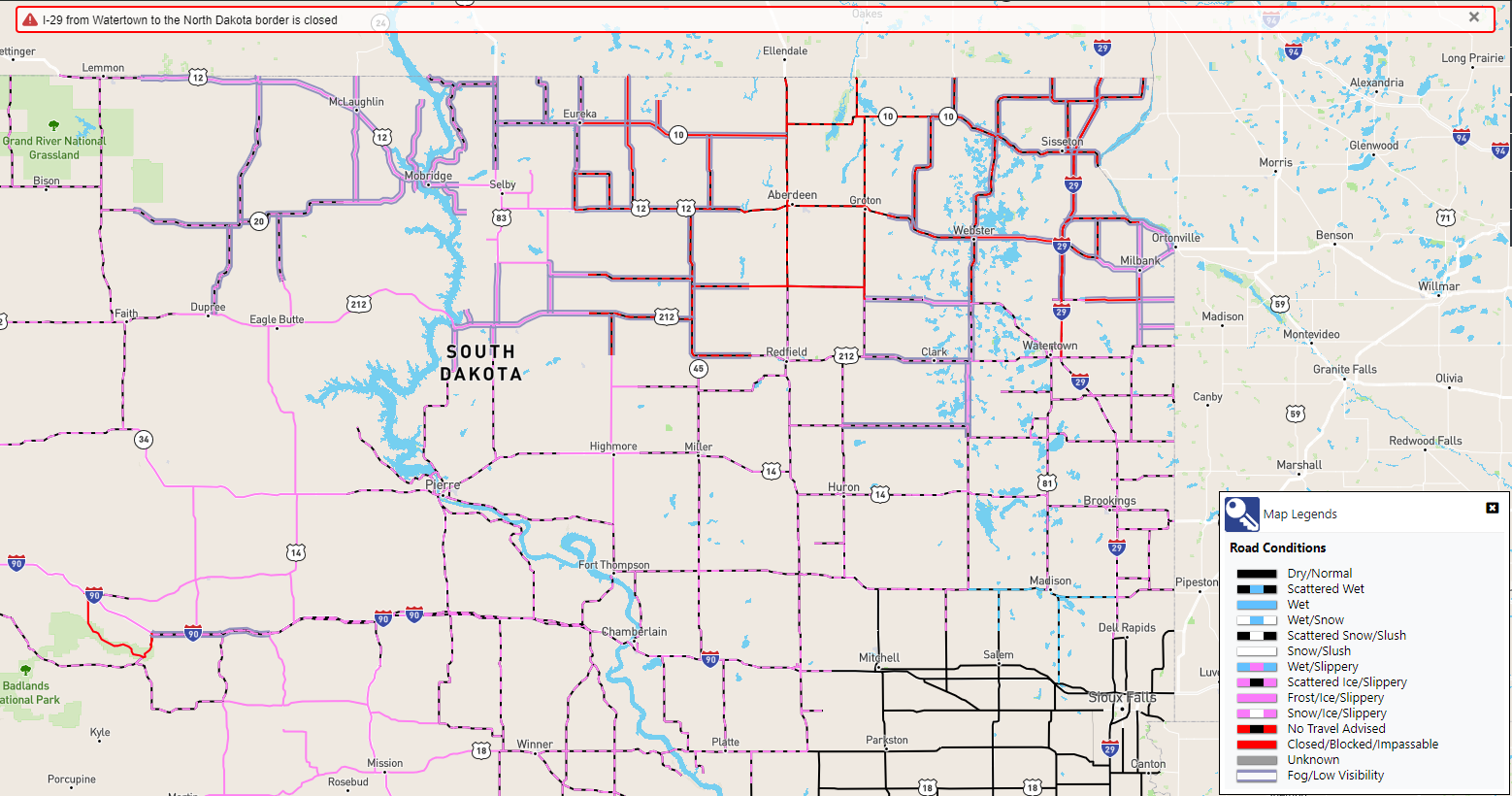
SD Road Conditions as of 10:30 AM on April 5th (Via SD511.org)
List of snowfall reports
..TIME...   ...EVENT...      ...CITY LOCATION...     ...LAT.LON...
..DATE...   ....MAG....      ..COUNTY LOCATION..ST.. ...SOURCE....
            ..REMARKS..

0600 AM     Snow             7 E Hayes               44.37N 100.89W
04/05/2023  M18.0 inch       Stanley            SD   CO-OP Observer

            CO-OP Observer station AYES2 Hayes 6 E. 48
            hour snowfall. 16 inches fell in the last 24
            hours.

0700 AM     Snow             8 SSW Seneca            44.94N 99.55W
04/05/2023  M16.0 inch       Faulk              SD   Cocorahs

            Cocorahs station SD-FK-8 Seneca 8.3 SSW. 48
            hour snowfall.

0800 AM     Snow             1 W Roscoe              45.45N 99.35W
04/05/2023  M15.6 inch       Edmunds            SD   CO-OP Observer

            CO-OP Observer station ROSS2 Roscoe. 48 hour
            snowfall total. 15.1 inches fell in the past
            24 hours.

0600 AM     Snow             9 E Grey Goose          44.49N 100.17W
04/05/2023  M15.0 inch       Hughes             SD   Cocorahs

            Cocorahs station SD-HG-33 Pierre 11.3 NE.

0600 AM     Snow             3 NW Westport           45.68N 98.53W
04/05/2023  M14.0 inch       Brown              SD   CO-OP Observer

            CO-OP Observer station WPTS2 Westport 2 NW.
            48 hour snowfall.

0700 AM     Snow             3 NW Westport           45.68N 98.53W
04/05/2023  M14.0 inch       Brown              SD   CO-OP Observer

            1.1 inches liquid. 24 hour snowfall.

0700 AM     Snow             Fort Pierre             44.36N 100.37W
04/05/2023  M12.5 inch       Stanley            SD   Cocorahs

            Cocorahs station SD-ST-6 Fort Pierre 0.5 SE.
            0.67 inches of liquid water equivalent. 48
            hour snowfall. 8.5 inches fell in the last
            24 hours.

0700 AM     Snow             Selby                   45.50N 100.03W
04/05/2023  M11.7 inch       Walworth           SD   CO-OP Observer

            CO-OP Observer station SBYS2 Selby. 0.88
            liquid water equivalent. 24 hour snowfall.

0700 AM     Snow             1 NNE Aberdeen          45.48N 98.47W
04/05/2023  M11.1 inch       Brown              SD   Cocorahs

            Cocorahs station SD-BR-1 Aberdeen 1.0 NNE.
            0.70 inches water equivalent. 48 hour
            snowfall. 10.2 inches fell in the last 24
            hours.

0800 AM     Snow             3 SW Sand Lake Wildlife 45.72N 98.30W
04/05/2023  M11.0 inch       Brown              SD   CO-OP Observer

            0.48 inches liquid equivalent. 48 hour
            snowfall. 7.0 inches fell in the last 24
            hours.

0700 AM     Snow             1 SE Pierre             44.35N 100.32W
04/05/2023  M10.0 inch       Hughes             SD   Cocorahs

            Cocorahs station SD-HG-10 Pierre 1 S. 0.78
            inches of liquid equivalent. 48 hour total
            snowfall. 7.5 inches of snow fell in the
            last 24 hours.

0800 AM     Snow             Faulkton                45.03N 99.13W
04/05/2023  M10.0 inch       Faulk              SD   CO-OP Observer

            CO-OP Observer station FAUS2 Faulkton 1 NW.
            1.0 inches liquid water equivalent. 48 hour
            snowfall. 7.0 inches fell in the last 24
            hours.

0700 AM     Snow             11 SW Eureka            45.66N 99.80W
04/05/2023  M10.0 inch       Campbell           SD   Cocorahs

            Cocorahs station SD-CP-9 Eureka 11 WSW. 24
            hour snowfall.

0700 AM     Snow             2 SSE Claremont         45.64N 98.00W
04/05/2023  M10.0 inch       Brown              SD   Cocorahs

            Cocorahs station SD-BR-3 Claremont 2 SSE. 36
            hour snowfall, 9.5 inches over the past 24
            hours. 0.99 inch liquid equivalent.

0700 AM     Snow             4 W Sisseton            45.66N 97.12W
04/05/2023  M9.7 inch        Roberts            SD   CO-OP Observer

            CO-OP Observer station SIWS2 Sisseton 3 W.
            Liquid equivalent 0.79. 9.2 inches in the
            past 24 hours. 48 hour snowfall.

0700 AM     Snow             1 SSW Aberdeen          45.45N 98.49W
04/05/2023  M9.5 inch        Brown              SD   Cocorahs

            Cocorahs station SD-BR-11 Aberdeen 1 SSW. 24
            hour snowfall.

0800 AM     Snow             3 WSW Long Lake         45.84N 99.27W
04/05/2023  M9.3 inch        McPherson          SD   Cocorahs

            Cocorahs station SD-MP-9 Long Lake 3.1 WSW.
            0.77 liquid water equivalent. 48 hour
            snowfall. 9.0 inches in the last 24 hours.

0700 AM     Snow             8 ENE Sisseton Municipa 45.69N 96.83W
04/05/2023  M9.0 inch        Roberts            SD   Cocorahs

            Cocorahs station SD-RB-4 Browns Valley 6 N.
            0.81 inches of liquid water equivalent. 24
            hour snowfall. A trace of snow fell in the
            previous 24 hour period.

0700 AM     Snow             4 W Chelsea             45.17N 98.82W
04/05/2023  M9.0 inch        Faulk              SD   Cocorahs

            Cocorahs station SD-FK-6 Chelsea 3.8 W. 36
            hour snowfall total.

0700 AM     Snow             2 SSE Claremont         45.64N 98.00W
04/05/2023  M9.0 inch        Brown              SD   Cocorahs

            Cocorahs station SD-BR-3 Claremont 2 SSE. 36
            hour snowfall total.

0800 AM     Snow             7 WNW Hecla             45.92N 98.29W
04/05/2023  M9.0 inch        Brown              SD   Cocorahs

            Cocorahs station SD-BR-4 Hecla 7 WNW.

0700 AM     Snow             Britton                 45.78N 97.75W
04/05/2023  M8.7 inch        Marshall           SD   CO-OP Observer

            CO-OP Observer station BRIS2 Britton. 0.58
            inch liquid equivalent. 8.3 inch snowfall in
            the past 24 hours. 48 hour snowfall.

0800 AM     Snow             2 WNW Roy Lake State Pa 45.72N 97.48W
04/05/2023  M8.0 inch        Marshall           SD   CO-OP Observer

            CO-OP Observer station ROYS2 Lake City 3 W.
            0.74 inches liquid water equivalent. 48 hour
            snowfall. 6.0 inches fell in last 24 hours.

1005 AM     Snow             2 N Eagle Butte         45.02N 101.24W
04/05/2023  M8.0 inch        Dewey              SD   Cocorahs

            Cocorahs station SD-DW-5 North Eagle Butte
            1.7 NNW.

0900 AM     Snow             Murdo                   43.88N 100.72W
04/05/2023  M7.6 inch        Jones              SD   CO-OP Observer

            CO-OP Observer station MURS2 Murdo. 0.47
            inches of liquid water equivalent. 48 hour
            snowfall total. 4.1 inches of snow in the
            last 24 hours.

0700 AM     Snow             Turton                  45.05N 98.10W
04/05/2023  M7.0 inch        Spink              SD   CO-OP Observer

            CO-OP Observer station TURS2 Turton. 0.29
            liquid equivalent. 48 hour storm total
            snowfall. 6 inches in the past 24 hours.

0800 AM     Snow             2 S Doland              44.87N 98.10W
04/05/2023  M6.6 inch        Spink              SD   CO-OP Observer

            CO-OP Observer station DOLS2 Doland 2 S.
            0.50 inches of liquid water equivalent. 48
            hour snowfall totals. 4.1 inches fell in the
            last 24 hours.

0800 AM     Snow             Groton                  45.45N 98.10W
04/05/2023  M6.0 inch        Brown              SD   Public

            Storm total snow through 8 AM.

0800 AM     Snow             1 NNW Eureka            45.78N 99.63W
04/05/2023  M5.8 inch        McPherson          SD   CO-OP Observer

            CO-OP Observer station ERKS2 Eureka. 0.51
            inches liquid water equivalent. 48 hour
            snowfall. 5.4 inches in the last 24 hours.

0700 AM     Snow             8 N Vivian              44.04N 100.27W
04/05/2023  M5.5 inch        Lyman              SD   Cocorahs

            Cocorahs station SD-LY-5 Vivian 7 NNE. 060
            liquid water equivalent. 48 hour snowfall
            total. 4 inches fell in the last 24 hours.

1200 PM     Snow             Andover                 45.41N 97.91W
04/05/2023  M5.5 inch        Day                SD   CO-OP Observer

            CO-OP Observer station ANVS2 Andover. 0.55
            inches liquid equivalent. 48 hour snowfall.
            1.5 inches fell in the last 24 hours.

0800 AM     Snow             5 N Firesteel           45.49N 101.29W
04/05/2023  M5.0 inch        Corson             SD   Cocorahs

            Cocorahs station SD-CR-18 Isabel 9.5 NE.
            0.65 liquid water equivalent. 24 hour
            snowfall.

0600 AM     Snow             2 N Browns Valley       45.62N 96.83W
04/05/2023  M4.6 inch        Traverse           MN   CO-OP Observer

            CO-OP Observer station BRVM5 Browns Valley.
            24 hour snowfall. 0.45 inches of liquid.

0730 AM     Snow             Milbank                 45.22N 96.63W
04/05/2023  M4.5 inch        Grant              SD   CO-OP Observer

            CO-OP Observer station MLBS2 Milbank. Liquid
            equivalent 0.45. 3.0 inches of snow over the
            past 24 hours. 48 hour snowfall.

0700 AM     Snow             2 SE Roslyn             45.47N 97.47W
04/05/2023  M4.4 inch        Day                SD   Cocorahs

            Cocorahs station SD-DY-17 Roslyn 2 SE.

0800 AM     Snow             Mclaughlin              45.81N 100.81W
04/05/2023  M3.2 inch        Corson             SD   CO-OP Observer

            0.16 liquid water equivalent. 48 hour
            snowfall total. 2.0 inches fell in the last
            24 hours.

0600 AM     Snow             Clark                   44.88N 97.74W
04/05/2023  M3.0 inch        Clark              SD   CO-OP Observer

            CO-OP Observer station CAKS2 Clark. 0.32
            inch water equivalent. 1.3 inches of snow in
            the past 24 hours. 24 hour snowfall.

0809 AM     Snow             4 ENE Reliance          43.91N 99.53W
04/05/2023  M2.4 inch        Lyman              SD   Cocorahs

            Cocorahs station SD-LY-26 Reliance 4 ENE.

0725 AM     Snow             3 NNE Gann Valley       44.08N 98.97W
04/05/2023  M2.2 inch        Buffalo            SD   CO-OP Observer

            CO-OP Observer station GNVS2 Gann Valley 3
            NNE. 0.17 inches liquid water equivalent. 24
            hour snowfall.

0800 AM     Snow             1 WSW Webster           45.33N 97.53W
04/05/2023  M2.0 inch        Day                SD   CO-OP Observer

            CO-OP Observer station WBRS2 Webster. 0.55
            liquid equivalent. 48 hour snowfall. 1.1
            inches fell in the past 24 hours.

0700 AM     Snow             La Bolt                 45.05N 96.68W
04/05/2023  M1.5 inch        Grant              SD   Cocorahs

            Cocorahs station SD-GT-9 LaBolt. 0.51 inches
            liquid equivalent. 24 hour snowfall.

0600 AM     Snow             Watertown               44.91N 97.12W
04/05/2023  M1.5 inch        Codington          SD   CO-OP Observer

            CO-OP Observer station WATS2 Watertown.
April 4-5th Photos
 |
 |
 |
 |
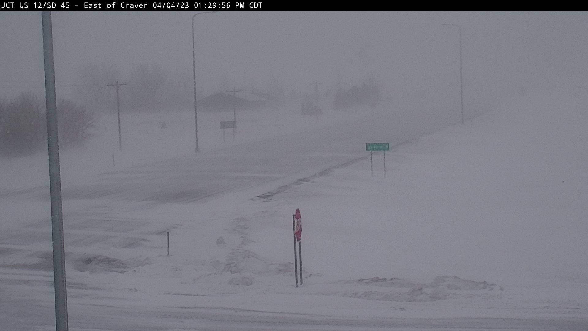
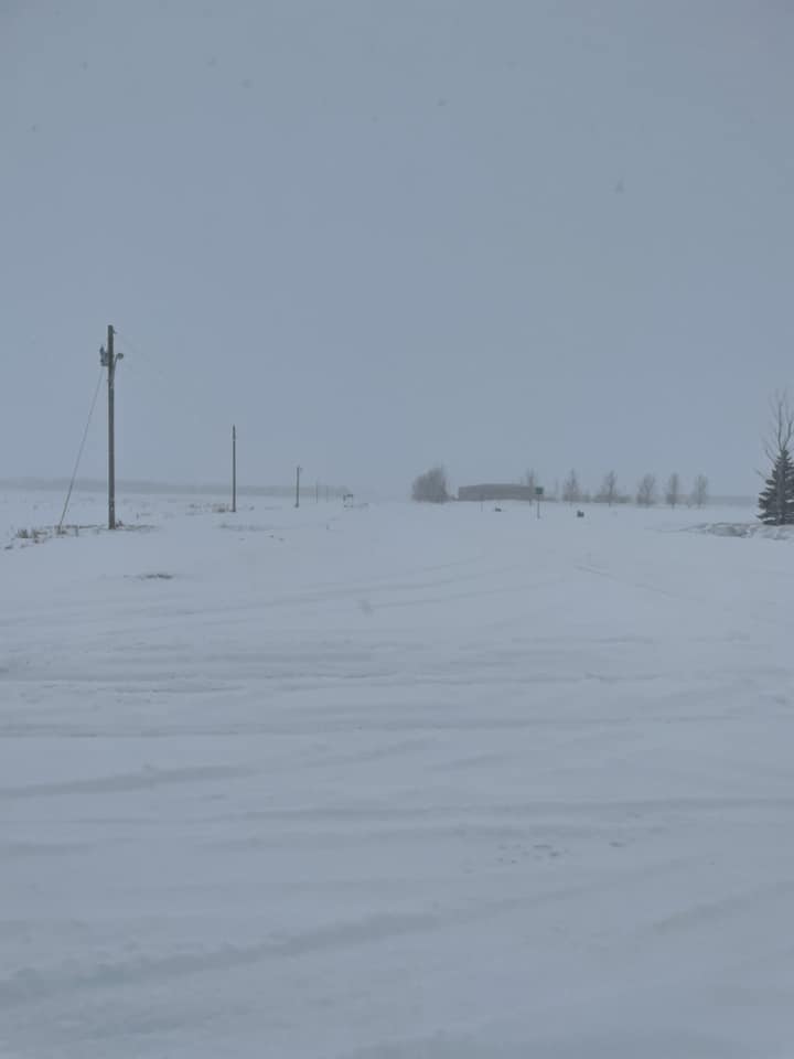
| View of US12 from Craven's Corner, near Ipswich, SD at 1:30 PM on April 4th. Visibility from falling snow was less than 1/2 mile. (Image from SD DOT) | Large drift next to a house 2 miles east of Barnard, SD (Brittany Foley) | Photo Courtesy of the Brown County Sheriff, taken at 10am on April 4th | Photo courtesy of the Grant County EM, taken around 2pm on April 5th |
 |
 |
 |
 |
| Photo courtesy of the Grant County EM, taken around 2pm on April 5th | SD Highway 12 near Summit, at 5:55pm on April 4th (SD Highway Patrol) | Near Vivian during the afternoon of April 5th (Jones County EM) | April 4th in Murdo (Jones County EM) |
 |
 |
 |
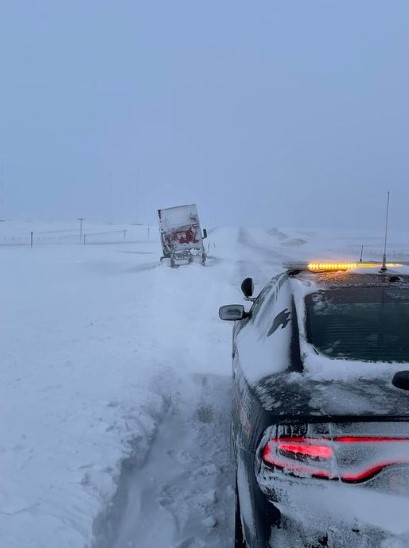 |
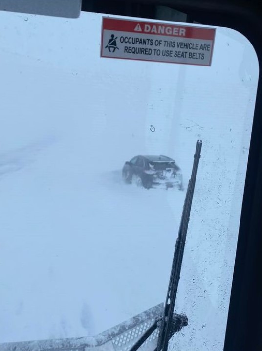
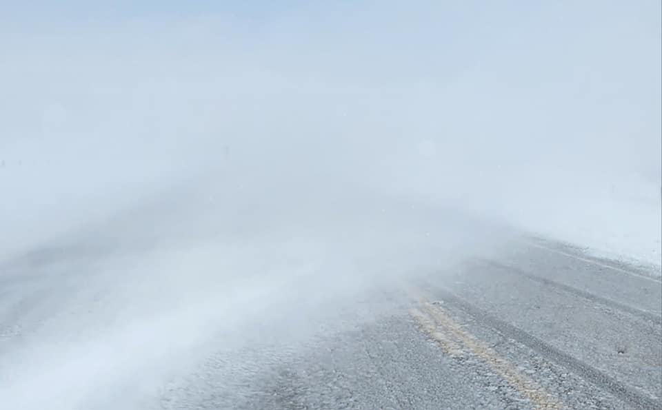
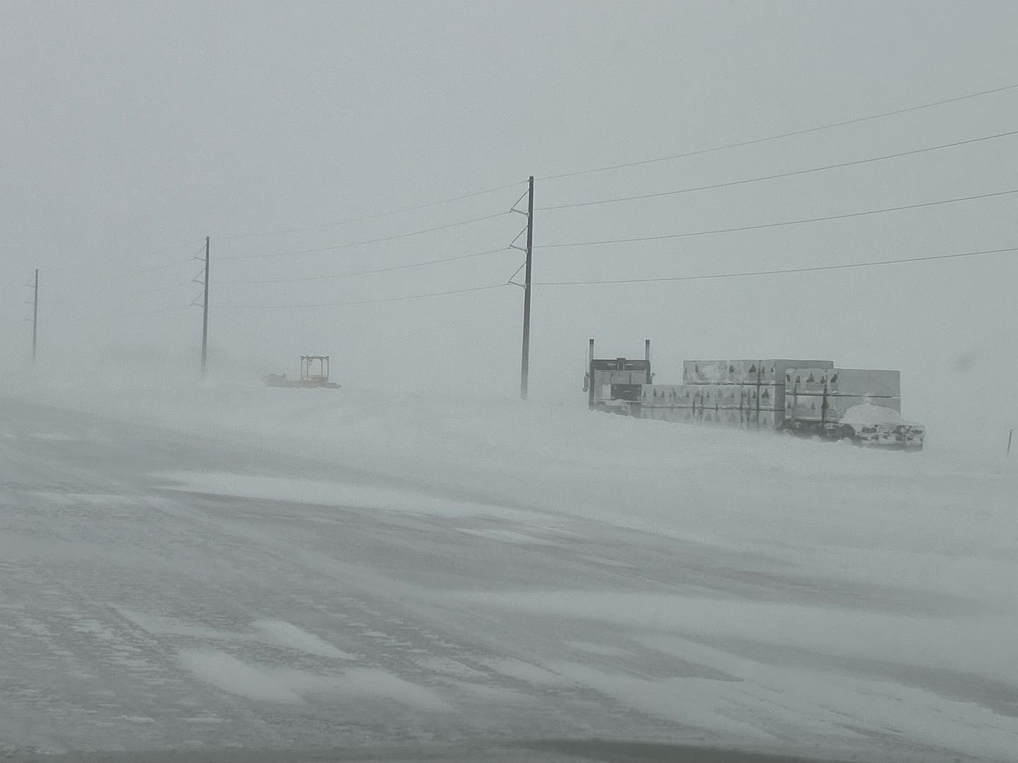
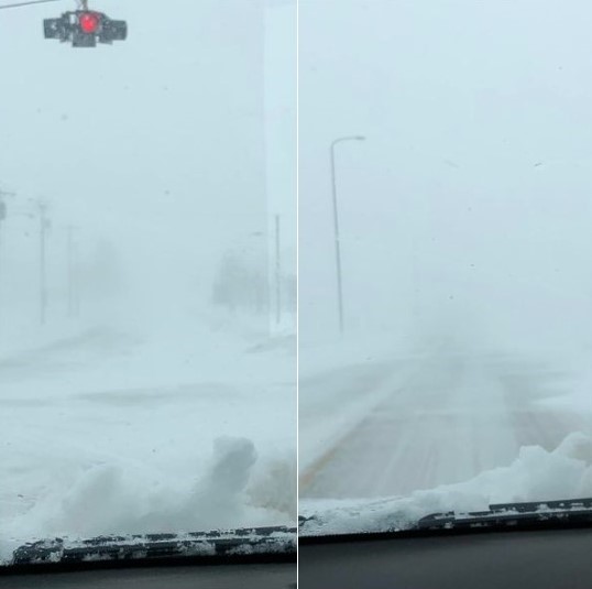
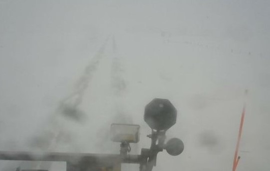
| The scene from a SDDOT plow near Sisseton around 1:15pm on April 4th | Reduced visibility from blowing snow on SD Highway 15 near Wilmot on April 5th (SD Highway Patrol) | I-29 near the New Effington exit around 11am on April 4th (SD Highway Patrol) | US Highway 83 near Selby at 10am on April 5th (SD Highway Patrol) |
 |
Media use of NWS Web News Stories is encouraged! Please acknowledge the NWS as the source of any news information accessed from this site. |
|

