Widespread life-threatening flash and urban flooding continues in south-central Texas, with considerable flooding impacts possible across central Texas. Wildfire smoke is impacting air quality across much of the Great Lakes region into southern New England and the Mid-Atlantic. Monsoonal thunderstorms may produce isolated to scattered flash flooding across the Southwest into the Great Basin. Read More >
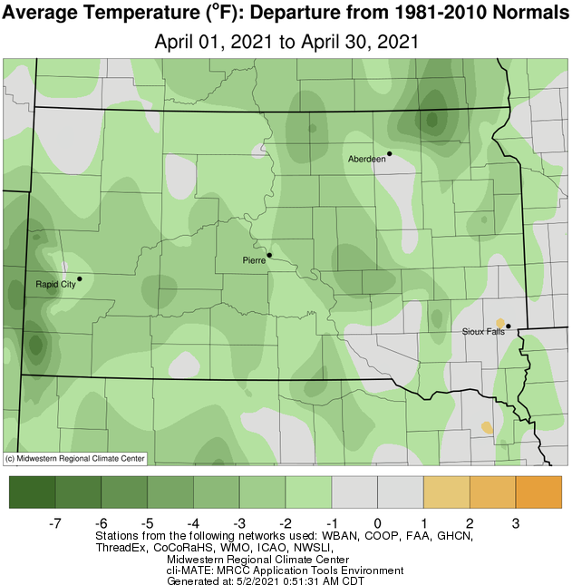
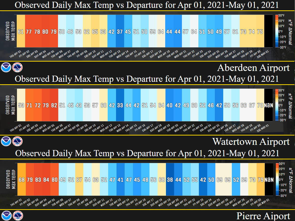
Temperatures finished near to slightly below normal on the whole across the area this April. The first 5 days featured record-territory warmth with highs in the 70s and 80s. In fact, Pierre and Mobridge set daily record highs on the 2nd, 3rd, and/or 4th. However, much of the remainder of the month would feature near normal to below normal temperatures. Some of the coldest air was observed on the 19-25th, when Pierre and Mobridge set at least one record low temperature each.
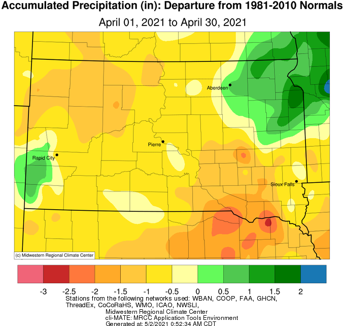
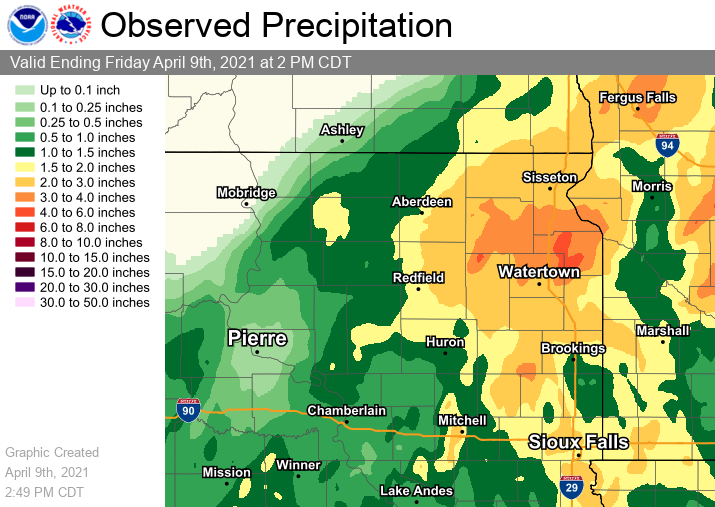
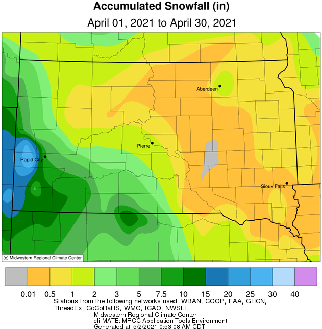
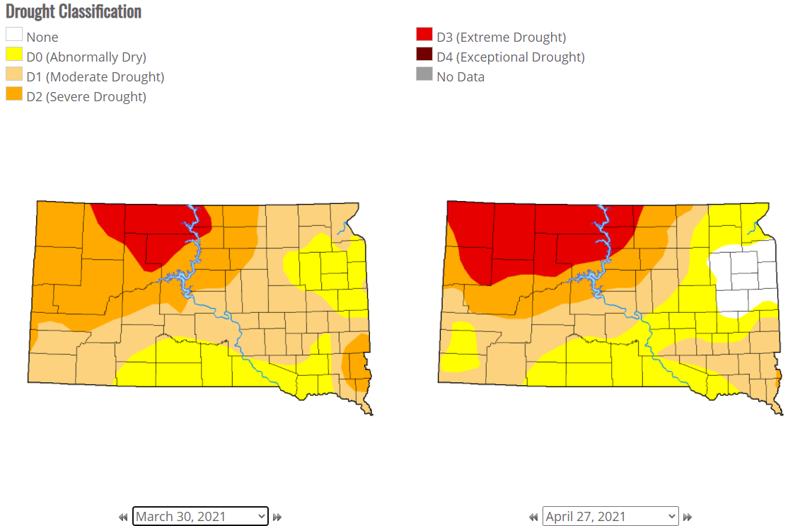
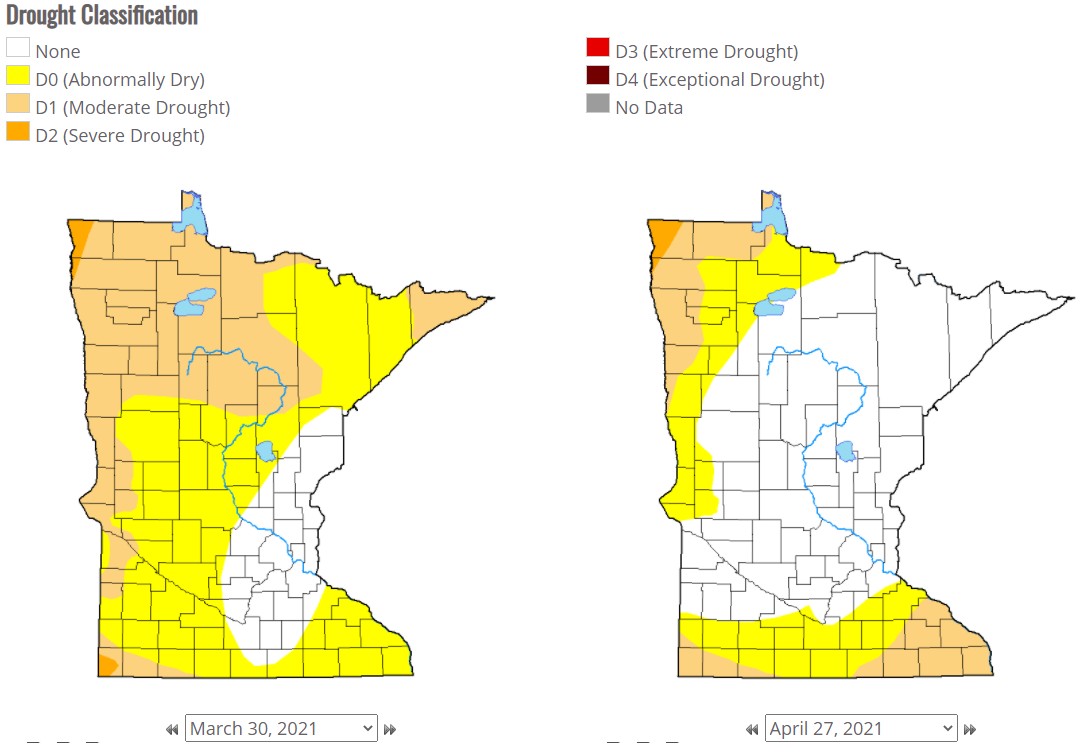
Brown/Spink Counties and areas to the east recorded above average amounts of precipitation (by as much as around three quarters of an inch at Aberdeen and Wheaton), while the rest of the area was below average (by as much as around an inch at Mobridge and Timber Lake). For those with a surplus, much of the rain fell over a 3-day period from April 6-8th when a large, slow moving low pressure system tracked through. Daily records were set on the 7th at Aberdeen, Watertown and Sisseton when over an inch fell. The bullseye of this system was across Day, Roberts, Big Stone, Clark, Codington and Grant Counties where there was a storm total of 3 to 4 plus inches of rain. This led to river rises to near action flood stage in a few cases. As far as snowfall goes, the whole area recorded below average amounts. There were just a few days where at least a trace of snow fell (a few of which led to icy roads), but the most notable in terms of accumulations took place on the 20th from McPherson southeast to Deuel County during the afternoon and evening – up to 2 to 4” fell (fairly localized). Drought conditions worsened over the course of the month across north central SD, but improved or disappeared across portions of northeastern SD and west central MN.
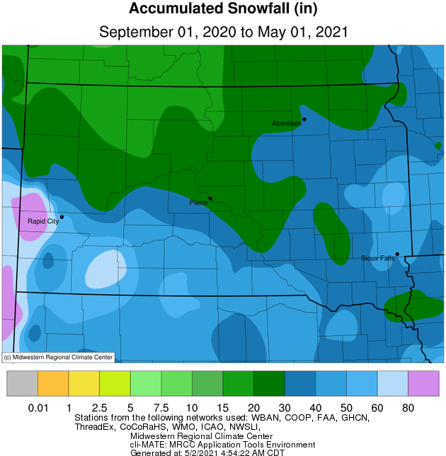
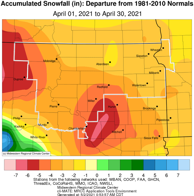
Finally, below are the snowfall totals as of May 1st for the 2020-2021 cold season vs normal (based on the 1981-2010 climate normals – an update to these normal will take place in a couple days on May 4th).
Aberdeen: 31.7” vs 38.1” (-6.4”)
Watertown: 32.6” vs 35.9” (-3.3”)
Sisseton: 23.7” vs 44.5” (-20.8”)
Pierre: 24.2” vs 31.9” (-7.7”)
Mobridge: 17.2” vs 31.1” (-13.9”)
|
April 2021 |
||||
|
Temperature Data |
Aberdeen |
Sisseton |
Wheaton |
Watertown |
|
Warmest Temperature / Date |
80 / 4th |
79 / 5th |
76 / 5th |
82 / 5th |
|
Coldest Temperature / Date |
12 / 1st |
15 / 1st |
16 / 1st |
15 / 1st |
|
Average High / Departure from Normal |
58.7 / +1.7 |
56.4 / +0.1 |
53.1 / -2.1 |
54.8 / -0.8 |
|
Average Low / Departure from Normal |
30.6 / -1.2 |
33.0 / +0.4 |
32.7 / +0.7 |
31.2 / -0.9 |
|
Monthly Average / Departure from Normal |
44.7 / +0.3 |
44.7 / +0.2 |
42.9 / -0.7 |
43.0 / -0.8 |
|
Precipitation Data |
|
|
|
|
|
Monthly Precipitation / Departure from Normal |
2.59 / +0.74 |
2.66 / +0.38 |
2.94 / +0.70 |
2.44 / +0.42 |
|
Most Precipitation in 24 hours / Date |
1.41 / 7th |
1.56 / 7th |
1.24 / 7th |
1.01 / 7th |
|
Monthly Snowfall / Departure from Normal |
1.7 / -1.4 |
T / -3.8 |
T / -4.4 |
0.9 / -2.4 |
|
Most Snow in 24 hours / Date |
1.6 / 20th |
T / 5 days |
T / 4 days |
0.6 / 20th |
|
Temperature Data |
Pierre |
Kennebec |
Mobridge |
Timber Lake |
|
Warmest Temperature / Date |
84 / 4th |
86 / 4th |
84 / 4th |
80 / 4th, 5th |
|
Coldest Temperature / Date |
18 / 20th |
14 / 20th |
17/20,21,24th |
16 / 21st |
|
Average High / Departure from Normal |
59.2 / -0.5 |
61.9 / -0.3 |
60.0 / +2.0 |
58.8 / +0.0 |
|
Average Low / Departure from Normal |
30.9 / -3.3 |
30.7 / -3.3 |
29.5 / -3.0 |
29.7 / -3.0 |
|
Monthly Average / Departure from Normal |
45.1 / -1.9 |
46.5 / -1.6 |
44.7 / -0.6 |
44.5 / -1.3 |
|
Precipitation Data |
|
|
|
|
|
Monthly Precipitation / Departure from Normal |
1.28 / -0.53 |
1.90 / -0.26 |
0.50 / -1.07 |
0.74 / -0.96 |
|
Most Precipitation in 24 hours / Date |
0.81 / 6th |
1.14 / 7th |
0.18 / 26th |
0.34 / 26th |
|
Monthly Snowfall / Departure from Normal |
T / -4.1 |
T / -3.9 |
T / -3.2 |
T / -5.3 |
|
Most Snow in 24 hours / Date |
T / 5 days |
T / 20th, 21st |
T / 5 days |
T / 12,13,20th |
Average temperature departure from normal this April on the whole, courtesy of the Midwestern Regional Climate Center
Daily high temperatures (value) and departures from normal (box shading) at Aberdeen, Watertown and Pierre.
Total precipitation this April (left) and departures from normal (right), courtesy of the Midwestern Regional Climate Center
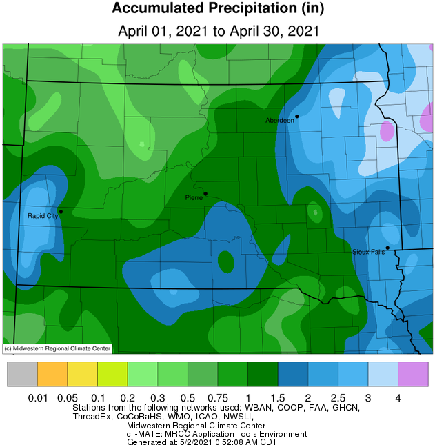
Total observed rainfall from April 6-8th.
Total snowfall this April (left) and departures from normal (right), courtesy of the Midwestern Regional Climate Center
US Drought Monitor comparison between the beginning (left) and end (right) of the month in South Dakota and Minnesota.
Total snowfall during the 2020-2021 cold season, as of May 1st, 2021, courtesy of the Midwestern Regional Climate Center