Overview
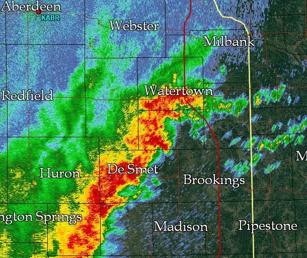
An active pattern set up across South Dakota from August 9th-11th, in which round after round of severe storms and heavy rain developed and moved east. The last round in this series developed in a very moisture-laden environment across eastern South Dakota on Thursday evening, August 11th, and produced very heavy rainfall primarily across Clark, Codington, Hamlin, and Deuel counties. Flooding resulted, with Watertown, SD being among the hardest hit.
Flooding
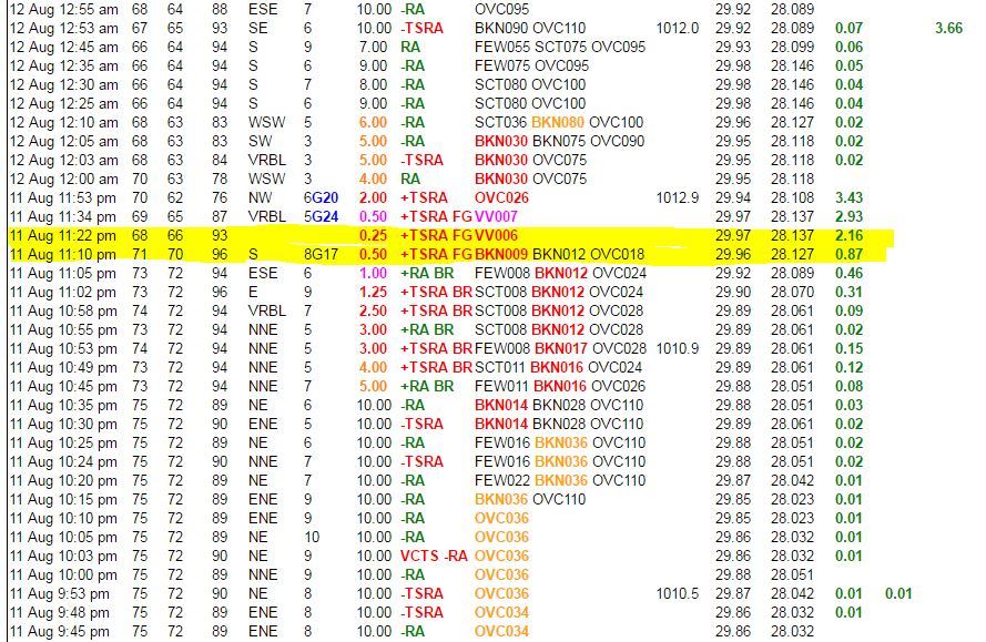
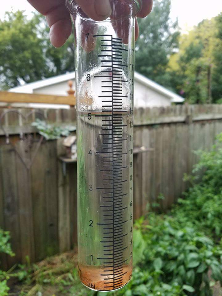
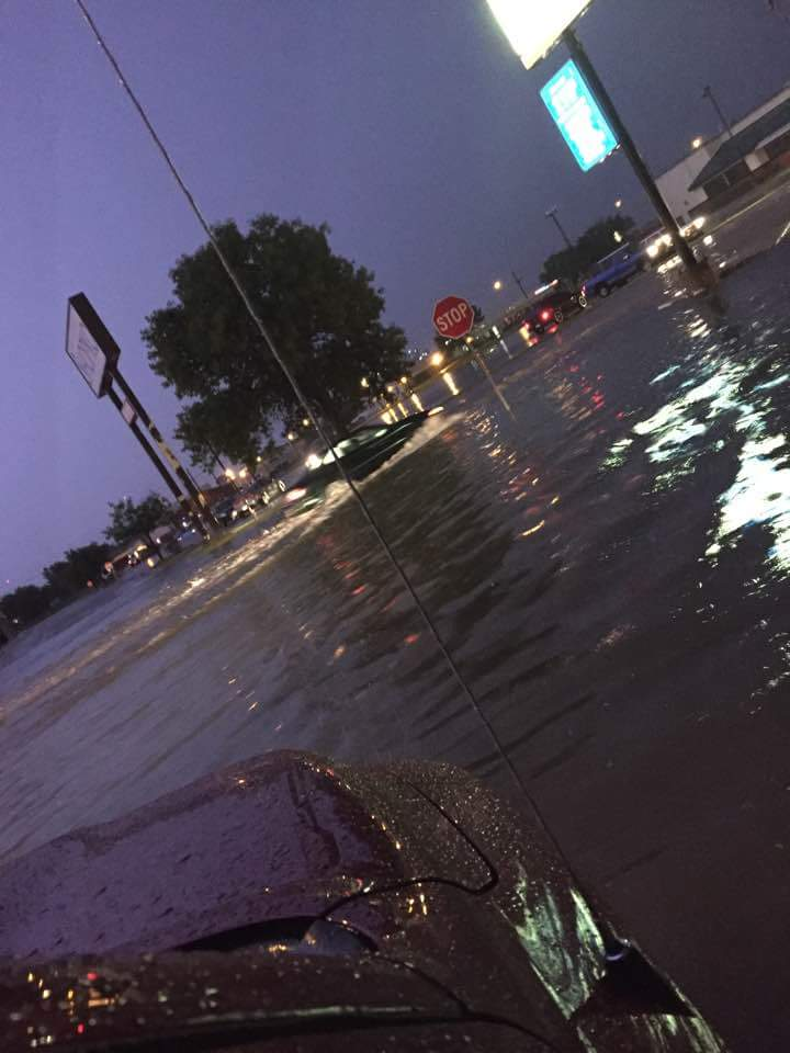
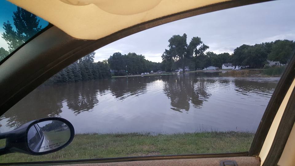
Too much rain fell far too fast for the soil to soak up Thursday evening. The urban setting across Watertown exacerbated the issue, as drainage systems backed up. A total of 3.90" of rain was recorded at the Watertown airport on August 11th, which broke the previous daily rainfall record of 1.66" in 1974. Amazingly, 3.29" of that total fell during a one hour period from 11 pm to midnight, and 1.29" of THAT amount fell within a 12 minute period from 11:10-11:22 pm. Additionally, 1.45" fell at the airport the previous night, August 10th, making soils more saturated and less able to handle this second and more intense round of rainfall. It's also worth noting that the Watertown airport is positioned on the far northeast side of town near Lake Kampeska. The heaviest of the rains fell further south as indicated on radar, and indeed upwards of 5" of rain was reported in several cases from Watertown proper.
At the airport, only 3 other calendar days observed 3.90" or more since records began in 1893 (4.32" on 8-20-2002, 4.35" on 6-15-1977, and 7.14" on 5-27-1931). Flooding quickly resulted in town, especially along highway 212 and near the Shopko, with many businesses and homes affected. One rescue was performed on Hwy 20 by the sheriff's department as multiple vehicles were stalled in the water. Reportedly, as of 1 pm CDT on Friday August 12th, the situation was improving as waters were receding across town. Areas outside of town were doing better with less impacts noted.
River gauge, other data
 |
.jpeg) |
 |
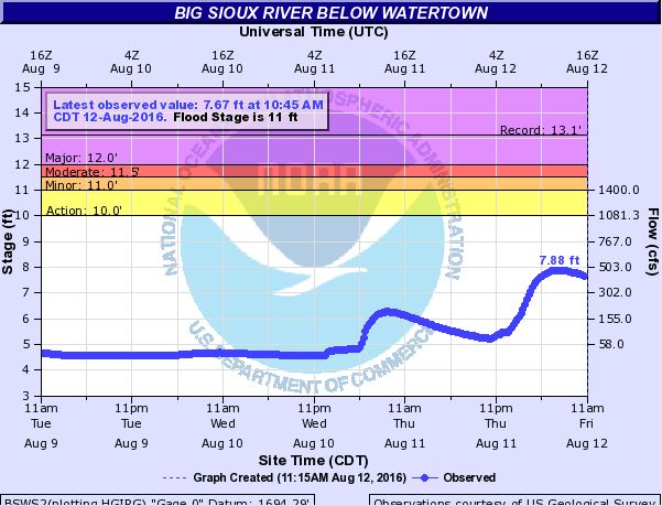 |
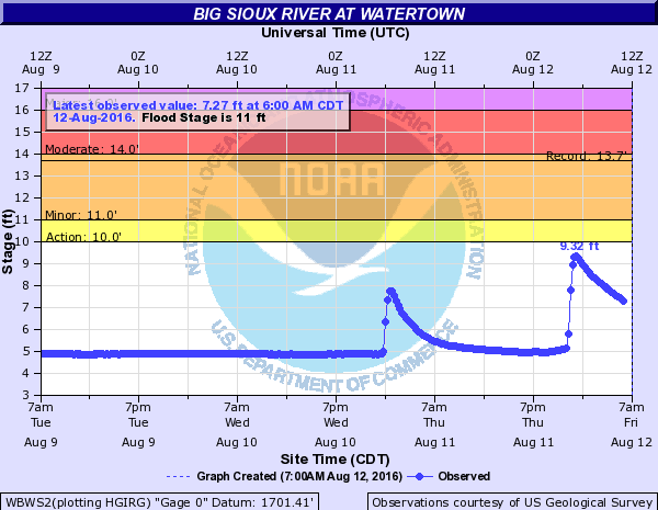
| 1.29" of rain at the Watertown airport in just 12 minutes, from 11:10-11:22 pm: https://goo.gl/N8fDq1 | Graph of precipitation accumulation over the past 48 hours+ at the Watertown airport. ~5.5" fell | Big Sioux River at Watertown river gauge shows two distinct rounds of heavy rain briefly spiking river levels | Big Sioux River below Watertown river gauge shows water levels receding |
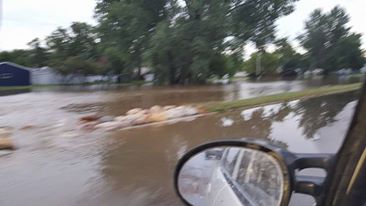
Photos from Watertown area
 |
 |
 |
 |
| Courtesy of Paul Endres | Courtesy of Matt Routh | Courtesy of Angela Hillberg | Courtesy of Paul Endres |
Radar:
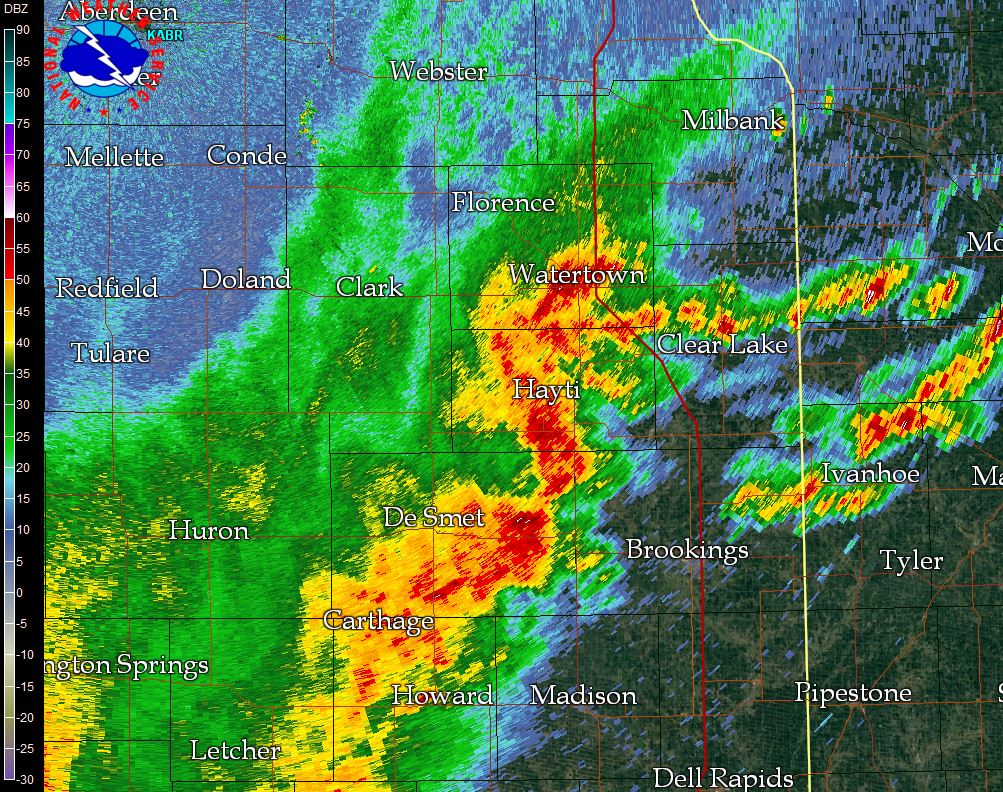
Heavy rain-producing squall line across eastern South Dakota
 |
 |
 |
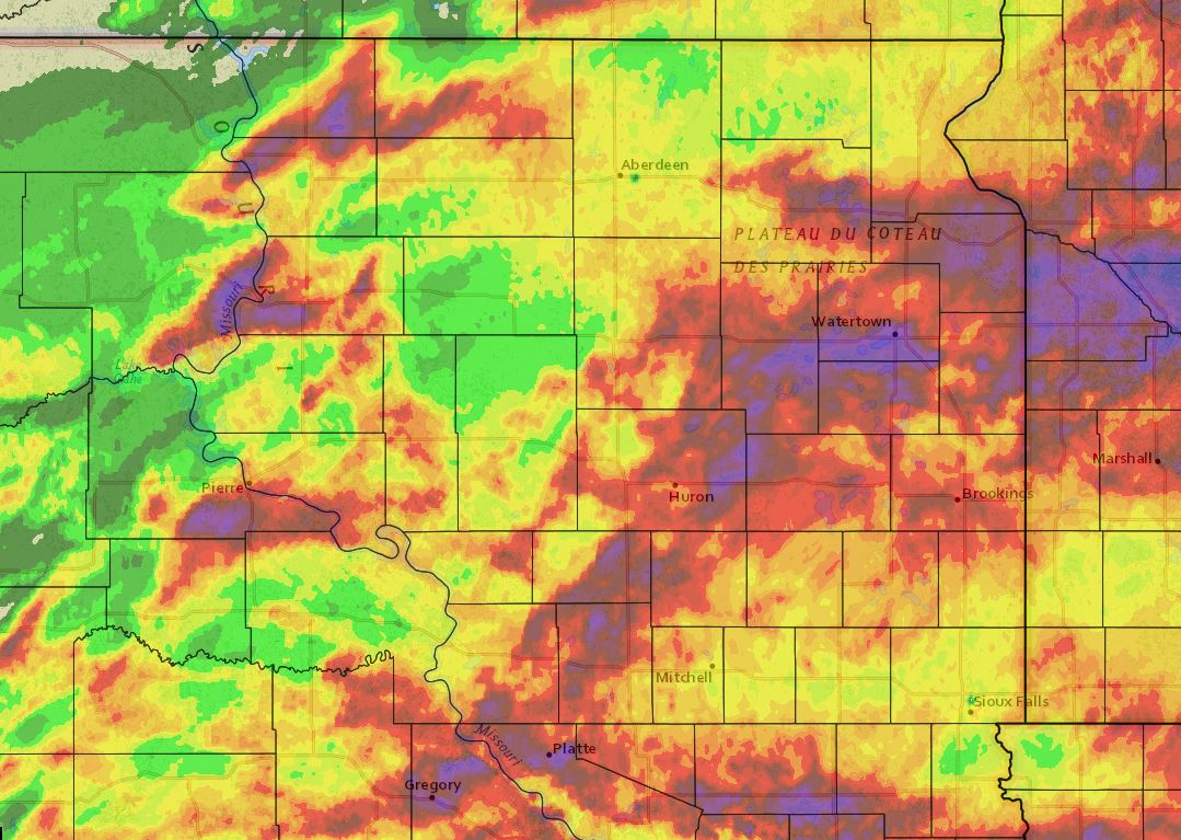 |
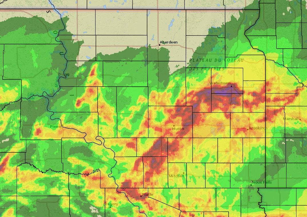
| Radar reflectivity at 11:20 pm August 11th as the system pivots over Watertown | Radar reflectivity at 11:24 pm August 11th as the system pivots over Watertown | 24 hour radar estimated rainfall totals: 7 am 8/11/16 to 7 am 8/12/16 | 48 hour radar estimated rainfall totals: 7 am 8/10/16 to 7 am 8/12/16 |
Storm Reports
Although the line that affected eastern South Dakota August 11th remained primarily below severe limits in terms of wind and hail, there were a few storms across central South Dakota that were severe. Additionally, many severe storms affected the state on August 10th. Find both this information here:
August 11th SPC Storm Reports: http://www.spc.noaa.gov/climo/gmf.php?rpt=160811_rpts_filtered
August 10th SPC Storm Reports: http://www.spc.noaa.gov/climo/gmf.php?rpt=160810_rpts_filtered
Rain Reports
Past 24 hour Rainfall Amounts (7 am Aug 11th to 7 am Aug 12th)

Location                     Amount    Time/Date       Lat/Lon
3 E Watertown                5.00 in   1000 AM 08/12   44.91N/97.11W
3 W Castlewood               4.80 in   0900 AM 08/12   44.73N/97.09W
4 E Watertown                4.78 in   0800 AM 08/12   44.92N/97.09W
4 N Thomas                   4.18 in   0700 AM 08/12   44.82N/97.21W
2 E Watertown                3.95 in   0700 AM 08/12   44.91N/97.11W
3 E Watertown                3.95 in   0800 AM 08/12   44.91N/97.11W
Watertown Municipal Airport  3.91 in   0653 AM 08/12   44.91N/97.15W
3 E Watertown                3.81 in   0700 AM 08/12   44.92N/97.09W
Watertown 3 SE               3.61 in   1100 AM 08/12   44.89N/97.12W
Watertown  2 S               3.12 in   0800 AM 08/12   44.87N/97.12W
4 SE Watertown               3.12 in   0800 AM 08/12   44.87N/97.11W
Clark                        2.90 in   0800 AM 08/12   44.88N/97.73W
Clear Lake                   2.90 in   0708 AM 08/12   44.75N/96.68W
1 SSW Clear Lake             2.88 in   0800 AM 08/12   44.76N/96.69W
Hayti                        2.55 in   0705 AM 08/12   44.66N/97.21W
Clear Lake                   2.50 in   1155 AM 08/12   44.76N/96.69W
National Wildlife Refuge     2.26 in   0400 PM 08/11   45.43N/97.33W
Rauville 4 SSE               2.26 in   1100 AM 08/12   44.92N/97.05W
3.5 S Brandt                 2.02 in   0700 AM 08/12   44.61N/96.62W
2 W Watertown                1.93 in   0800 AM 08/12   44.91N/97.21W
Hayti 1 W                    1.93 in   0800 AM 08/12   44.66N/97.23W
1 ENE Sandy Shore State Park 1.93 in   0700 AM 08/12   44.91N/97.21W
1 SE Onida                   1.73 in   0700 AM 08/12   44.69N/100.05W
Harrold 5 N                  1.55 in   0800 AM 08/12   44.60N/99.73W
2 S Rauville                 1.50 in   0700 AM 08/12   44.94N/97.08W
Watertown 2 NNE              1.36 in   1115 AM 08/12   44.94N/97.15W
Tulare 4.5 SSW               1.32 in   0800 AM 08/12   44.68N/98.53W
Fort Pierre 2 S              1.30 in   1130 AM 08/12   44.33N/100.38W
2 SSW Iona                   1.25 in   0700 AM 08/12   43.50N/99.44W
7 WNW Gann Valley            1.08 in   0700 AM 08/12   44.08N/99.13W
Artichoke Lake               1.00 in   0900 PM 08/11   45.37N/96.13W
Lees Corner 8 E              1.00 in   1200 PM 08/12   44.08N/99.15W
3 ESE Rosseau                0.98 in   0700 AM 08/12   44.29N/100.01W
Harrold 3.8 ESE              0.96 in   0800 AM 08/12   44.51N/99.66W
1 NNE Sandy Shore State Park 0.94 in   0700 AM 08/12   44.92N/97.23W
2 W Willow Lake              0.85 in   0800 AM 08/12   44.63N/97.69W
Danforth 5 E                 0.83 in   1141 AM 08/12   44.24N/98.77W
5 SSE Onida                  0.83 in   0700 AM 08/12   44.62N/100.03W
Holabird 8.5 N               0.82 in   0700 AM 08/12   44.65N/99.60W
Fort Pierre 26.4 W           0.80 in   0800 AM 08/12   44.30N/100.91W
Fort Pierre                  0.77 in   0700 AM 08/12   44.36N/100.37W
Wallace 4 SW                 0.74 in   1200 PM 08/12   45.04N/97.55W
Browns Valley                0.65 in   0500 AM 08/12   45.62N/96.83W
Wallace 5 ENE                0.62 in   1159 AM 08/12   45.14N/97.39W
South Shore 8 W              0.60 in   1115 AM 08/12   45.11N/97.10W
Pierre 1 SW                  0.59 in   1158 AM 08/12   44.36N/100.34W
Harrold 14 NNW               0.53 in   0800 AM 08/12   44.71N/99.83W
Oacoma 9 WSW                 0.48 in   1201 PM 08/12   43.75N/99.56W
Watertown 7.6 ENE            0.47 in   0800 AM 08/12   44.96N/97.02W
Pierre Capitol               0.47 in   0640 AM 08/12   44.36N/100.33W
8 W Ames                     0.45 in   0700 AM 08/12   44.30N/99.26W
Pierre                       0.44 in   0700 AM 08/12   44.37N/100.32W
Pierre                       0.42 in   0800 AM 08/12   44.37N/100.33W
12 NNW Holabird              0.39 in   0700 AM 08/12   44.70N/99.63W
La Bolt                      0.38 in   0600 AM 08/12   45.05N/96.68W
Strandburg 2.5 NW            0.37 in   0700 AM 08/12   45.06N/96.80W
9 SW Marvin                  0.35 in   1000 AM 08/12   45.17N/97.07W
3 SSW Milbank                0.35 in   0800 AM 08/12   45.17N/96.65W
Miller                       0.34 in   0800 AM 08/12   44.52N/98.99W
Waverly                      0.33 in   1100 AM 08/12   45.00N/96.97W
17 N Holabird                0.33 in   0700 AM 08/12   44.78N/99.57W
Milbank                      0.28 in   0700 AM 08/12   45.23N/96.64W
Watertown 7 N                0.27 in   1100 AM 08/12   45.01N/97.11W
Past 24 hour rainfall totals: 7 am 8-11 through 7 am 8-12. Red is around 2" of rain with purple around 3-4" of rain.
Past 48 hour rainfall totals: 7 am 8-10 through 7 am 8-12. Red is around 2" of rain with purple around 3-4"
 |
Media use of NWS Web News Stories is encouraged! Please acknowledge the NWS as the source of any news information accessed from this site. |
|

