
Canadian wildfire smoke will push into the Midwest, worsening air quality. A frontal system brings severe storms from the Northern Plains to the Mid‑Atlantic the next few days. Heavy Gulf Coast rain is possible as we closely monitor tropical development, while monsoonal storms persist in the Southwest with heavy rainfall. Hazardous heat expands from the Plains into the Lower Mississippi Valley. Read More >
Overview
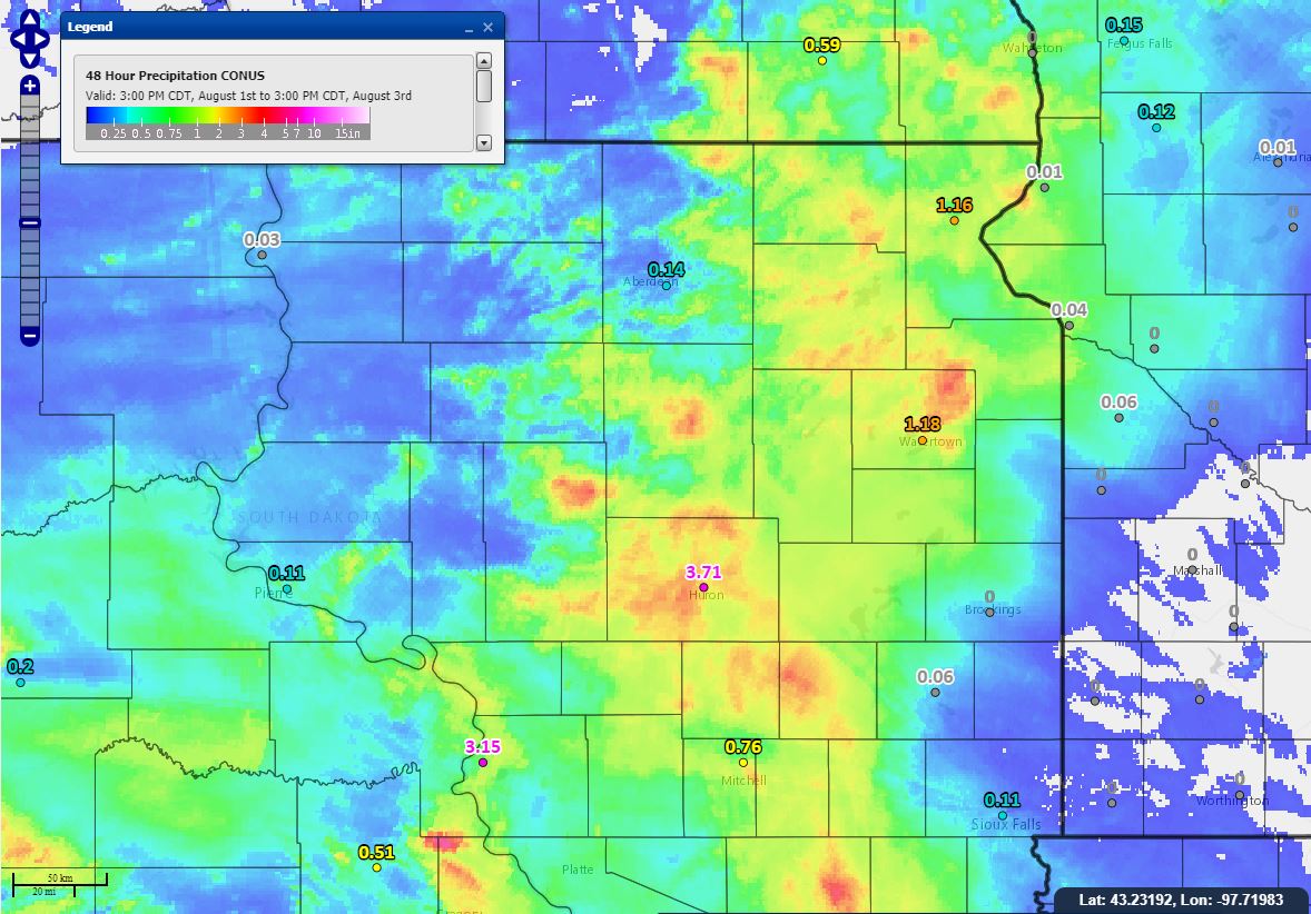
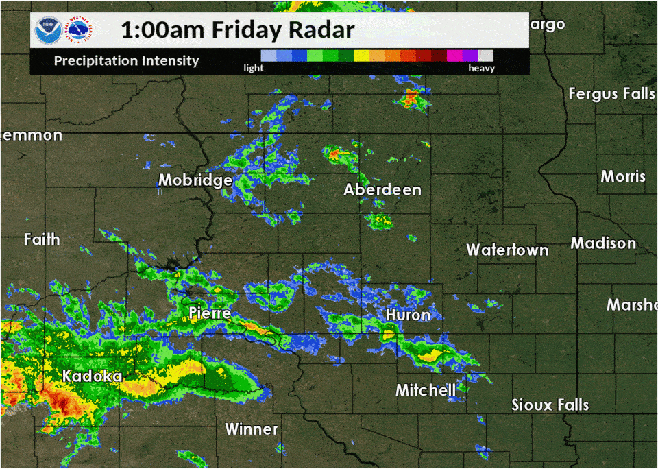
A very moist and stagnant atmosphere set the stage for heavy rains from slow-moving thunderstorms Friday morning, August 2nd. Several locations across the area observed up to 5-8". To make matters worse, this rain fell during a relatively short period of time with rainfall rates of 3+ inches per hour in some cases. As a result, flooding of property and several roadways resulted, and rivers rose to minor and moderate flood stages. Additional river rises to flood stage are forecast through the weekend as well, as a large volume of water continues to work its way through the river system.
Heavy Rain & Flooding
Rainfall and Flooding Reports Map, Hydrographs
 |
 |
 |
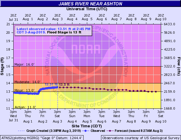 |
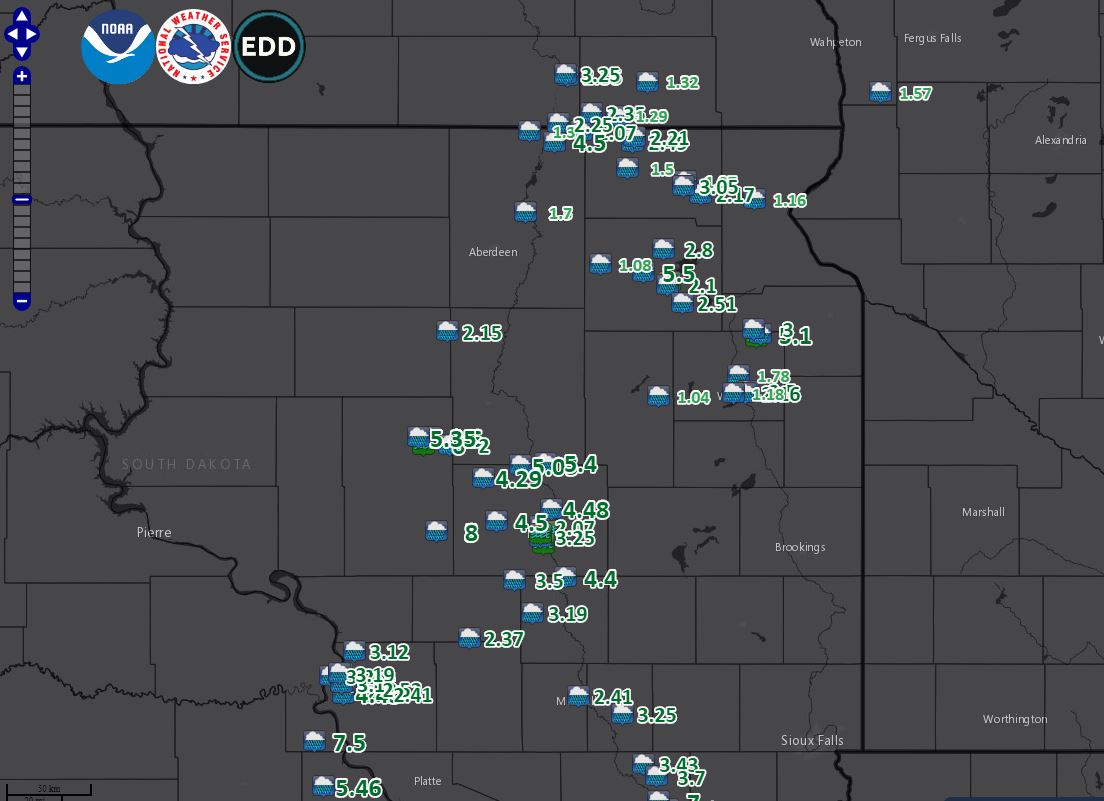
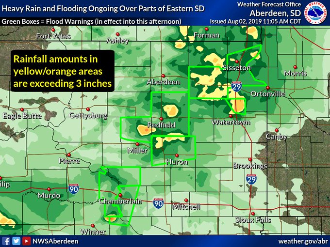
| Shading is of radar-estimated rainfall totals (underdone, despite our adjusting the radar to a setting more suitable for tropical environments) | Map of heavy rain and flooding reports across northeastern and central South Dakota | Extent of Flood Warnings as of 11am 8-2-19. Localized flooding continued in some areas into the day on the 3rd | Hydrograph for the James River near Ashton shows a spike in the river level into minor flood stage in response to the heavy rains |
 |
 |
 |
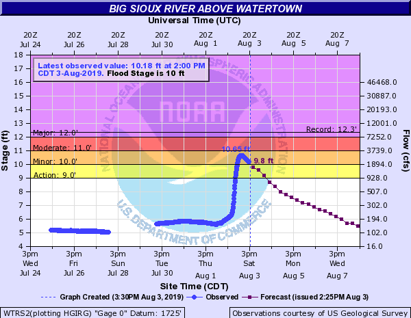 |
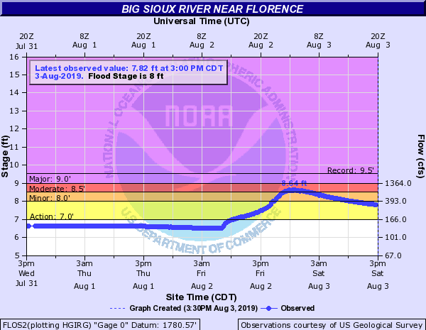
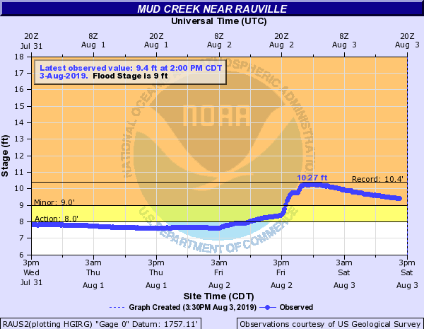
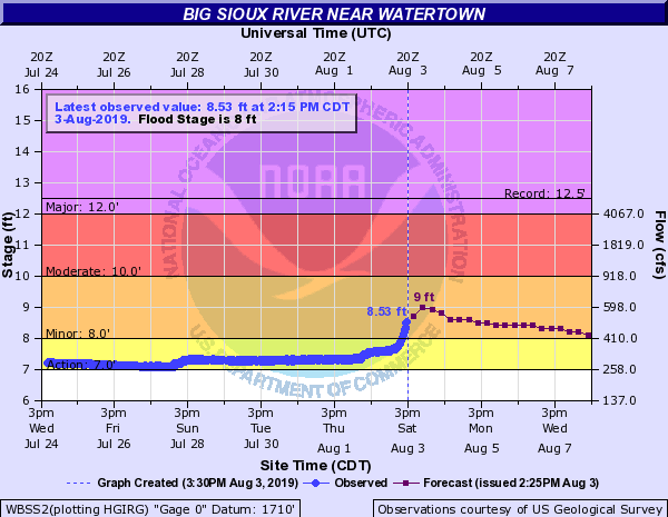
| Hydrograph for the Big Sioux River near Florence shows a spike in the river level into moderate flood stage in response to the heavy rains | Hydrograph for Mud Creek near Rauville shows a spike in the river level into minor flood stage in response to the heavy rains | Hydrograph for the Big Sioux River near Watertown shows a spike in the river level into minor flood stage in response to the heavy rains | Hydrograph for the Big Sioux River above Watertown shows a spike in the river level into minor flood stage in response to the heavy rains |
Listing of Rainfall and Flooding Reports
..TIME... ...EVENT... ...CITY LOCATION... ...LAT.LON...
..DATE... ....MAG.... ..COUNTY LOCATION..ST.. ...SOURCE....
..REMARKS..
0500 PM Heavy Rain 8 S Vayland 44.37N 98.80W
08/02/2019 M8.00 inch Hand SD Public
Updates previous heavy rain report from 8 S
Vayland. Public report relayed via the EM.
0500 PM Heavy Rain 2 W Iona 43.54N 99.47W
08/02/2019 M7.50 inch Lyman SD Public
Relayed via social media. Fell in under 3
hours.
1151 AM Heavy Rain 3 W Burdette 44.71N 98.87W
08/02/2019 E6.00 inch Hand SD Public
1031 AM Heavy Rain 5 ENE Bristol 45.38N 97.66W
08/02/2019 M5.50 inch Day SD Public
10 HOUR TOTAL. STILL RAINING.
0330 PM Heavy Rain 9 SSE Spink Colony 44.64N 98.20W
08/02/2019 M5.40 inch Spink SD Public
Relayed via social media.
1153 AM Heavy Rain 5 WNW Burdette 44.74N 98.90W
08/02/2019 M5.35 inch Hand SD Public
Updated rainfall total for this location.
0200 PM Heavy Rain 5 WNW South Shore 45.14N 97.02W
08/02/2019 M5.10 inch Codington SD Public
0307 PM Heavy Rain 8 E Spottswood 44.63N 98.34W
08/02/2019 E5.05 inch Spink SD Public
Relayed via social media.
1044 AM Heavy Rain 5 WNW Burdette 44.74N 98.90W
08/02/2019 M5.04 inch Hand SD Public
Report as of 10:44 am. Still raining.
0930 AM Heavy Rain 2 NNW Burdette 44.74N 98.83W
08/02/2019 M4.60 inch Hand SD Public
Report as of 9:30 AM, still raining.
0830 AM Heavy Rain Hecla 45.88N 98.15W
08/02/2019 M4.50 inch Brown SD Emergency Mngr
10 HOUR RAINFALL TOTAL.
0150 PM Heavy Rain Oacoma 43.80N 99.38W
08/02/2019 M3.25 inch Lyman SD Public
0600 PM Heavy Rain Roy Lake State Park 45.71N 97.44W
08/02/2019 M3.05 inch Marshall SD CO-OP Observer
0550 PM Heavy Rain 7 WNW South Shore 45.16N 97.06W
08/02/2019 M3.00 inch Grant SD CO-OP Observer
0750 AM Heavy Rain 3 WSW Roslyn 45.47N 97.55W
08/02/2019 M2.80 inch Day SD Public
Rainfall since about 4 AM CDT. Have had some
water in basement.
1000 AM Heavy Rain 7 SSE Webster 45.26N 97.45W
08/02/2019 M2.51 inch Day SD Trained Spotter
Still raining.
1200 PM Heavy Rain 4 E Watertown 44.92N 97.09W
08/02/2019 M2.50 inch Codington SD Public
12 HOUR TOTAL. STILL RAINING.
0700 AM Heavy Rain 1 SW Kidder 45.88N 97.72W
08/02/2019 M2.49 inch Marshall SD Cocorahs
0825 PM Heavy Rain 1 N Kidder 45.90N 97.71W
08/02/2019 M2.21 inch Marshall SD CO-OP Observer
0700 AM Heavy Rain 4 SE Lake City 45.68N 97.35W
08/02/2019 M2.17 inch Marshall SD Cocorahs
Cocorahs station SD-MR-13 Lake City 4 SE.
0310 PM Heavy Rain 3 E Watertown 44.91N 97.10W
08/02/2019 M2.16 inch Codington SD Broadcast Media
Relayed via social media.
1200 PM Heavy Rain 1 S Chelsea 45.15N 98.74W
08/02/2019 M2.15 inch Faulk SD Public
Still raining.
0800 AM Heavy Rain 1 WSW Webster 45.33N 97.53W
08/02/2019 M2.10 inch Day SD CO-OP Observer
0700 AM Heavy Rain 8 ENE Hecla 45.92N 98.00W
08/02/2019 M2.07 inch Brown SD CO-OP Observer
CO-OP Observer station BRTS2 Hecla 5 NE.
1030 AM Heavy Rain 4 E Burdette 44.71N 98.73W
08/02/2019 M2.00 inch Hand SD Public
Still raining.
1115 AM Heavy Rain 1 WNW Lake City 45.73N 97.43W
08/02/2019 M1.97 inch Marshall SD Trained Spotter
12 HOUR TOTAL. STILL RAINING.
0800 AM Heavy Rain 3 W Rauville 44.98N 97.14W
08/02/2019 M1.78 inch Codington SD CO-OP Observer
CO-OP Observer station RALS2 Rauville 2 W.
0521 PM Heavy Rain Columbia 45.61N 98.31W
08/02/2019 M1.70 inch Brown SD Emergency Mngr
0700 AM Heavy Rain Britton 45.78N 97.75W
08/02/2019 M1.50 inch Marshall SD CO-OP Observer
CO-OP Observer station BRIS2 Britton.
0700 AM Heavy Rain 7 WNW Hecla 45.92N 98.29W
08/02/2019 M1.30 inch Brown SD Cocorahs
Cocorahs station SD-BR-4 Hecla 7 WNW.
0700 AM Heavy Rain Columbia 45.61N 98.31W
08/02/2019 M1.30 inch Brown SD Emergency Mngr
0650 PM Heavy Rain Watertown 44.91N 97.17W
08/02/2019 M1.18 inch Codington SD ASOS
0651 PM Heavy Rain Sisseton 45.66N 97.05W
08/02/2019 M1.16 inch Roberts SD ASOS
1200 PM Heavy Rain Andover 45.41N 97.90W
08/02/2019 M1.08 inch Day SD CO-OP Observer
0330 PM Heavy Rain 4 S Garden City 44.90N 97.58W
08/02/2019 M1.04 inch Clark SD CO-OP Observer
1152 AM Flood 3 W Burdette 44.71N 98.87W
08/02/2019 Hand SD Public
Water over county and township roads, 6.0
inches of rain reported.
0732 AM Flood Webster 45.34N 97.52W
08/02/2019 Day SD Law Enforcement
WATER OVER SEVERAL AREA ROADWAYS.
1220 PM Flood 6 WNW South Shore 45.13N 97.04W
08/02/2019 Codington SD Public
County and township roads have water running
over them due to heavy rain.
Photos & Video
| 2 miles west of Iona, captured by and courtesy of Mark Kenzy around 1 pm, after his personal weather station recorded 7.5" of rain in less than 3 hours. A neighbor's KELO rain gauge measured 7.2" of rain as well. | Another video 2 miles west of Iona, captured by and courtesy of Mark Kenzy around 1 pm, after his personal weather station recorded 7.5" of rain in less than 3 hours. A neighbor's KELO rain gauge measured 7.2" of rain as well. |
 |
 |
 |
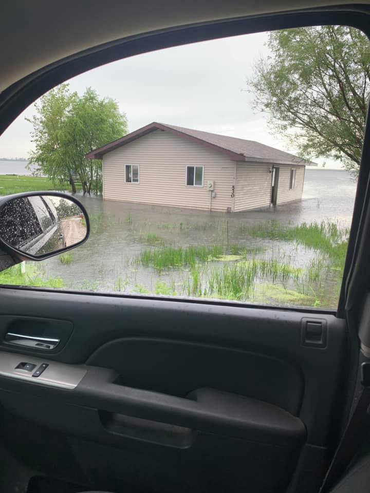 |
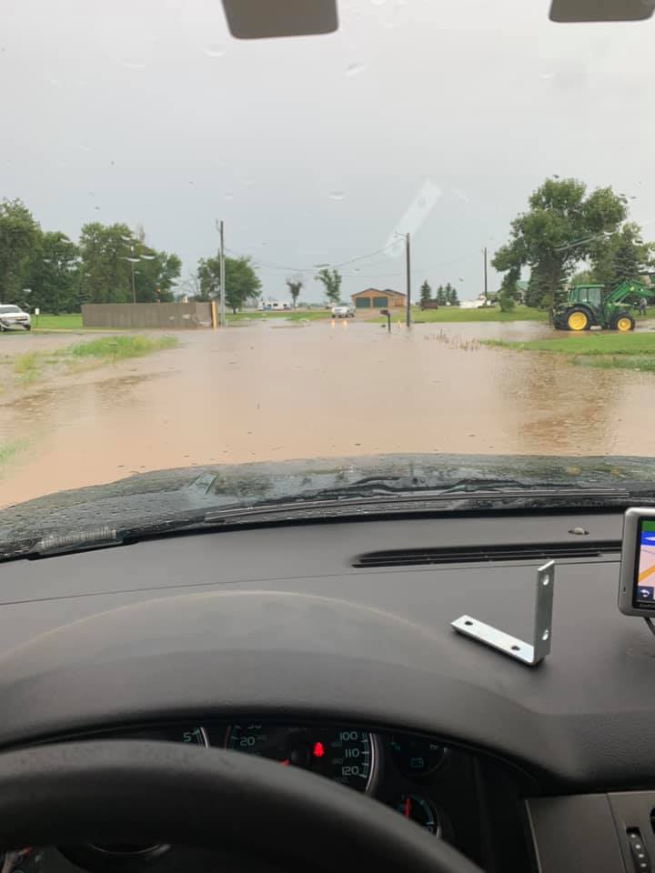
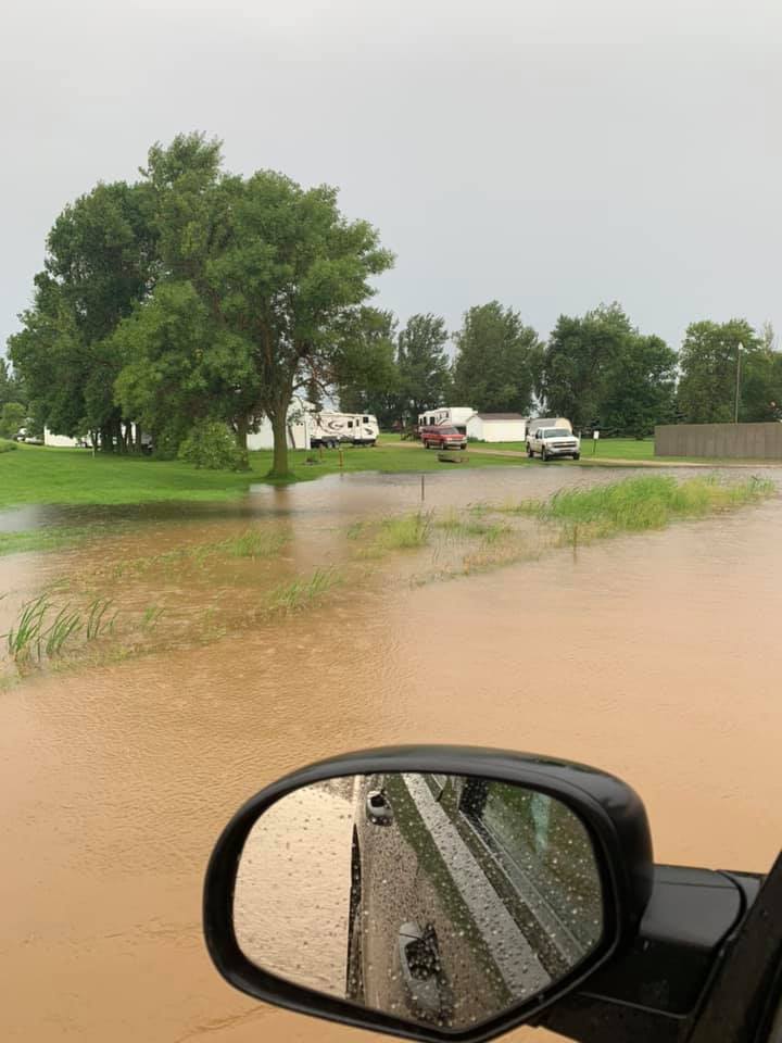
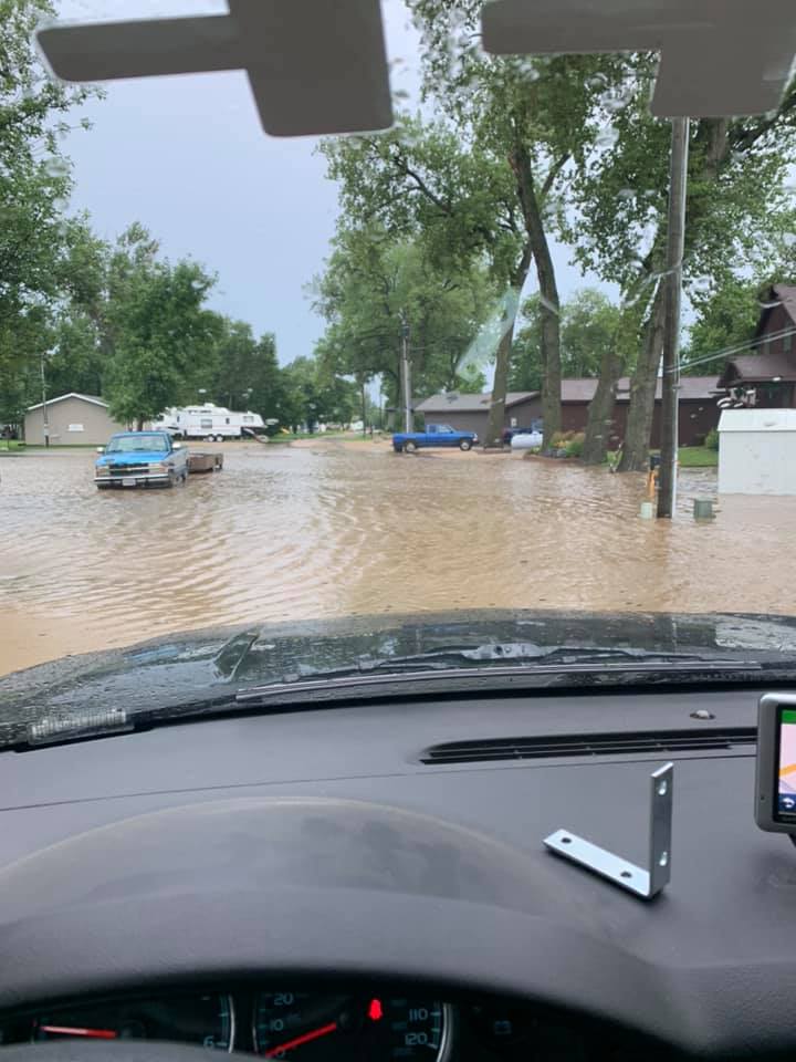
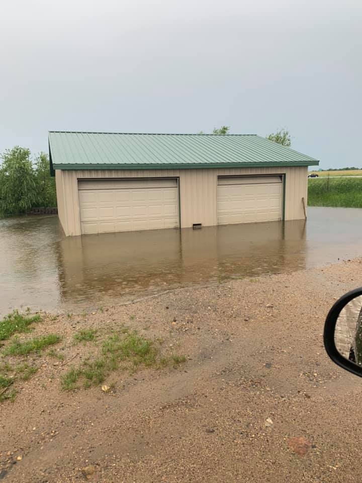
| Flooding at Blue Dog Lake. Photo by the Day County Sheriff | Flooding at Blue Dog Lake. Photo by the Day County Sheriff | Flooding at Blue Dog Lake. Photo by the Day County Sheriff | Flooding at Blue Dog Lake. Photo by the Day County Sheriff |
 |
 |
 |
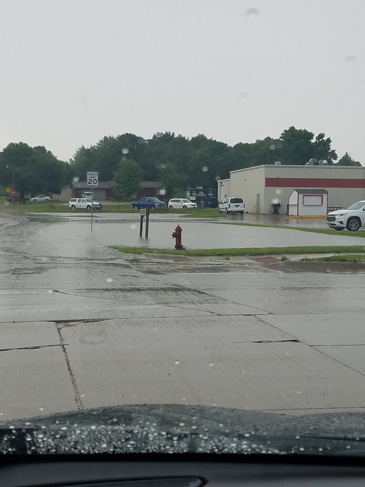 |
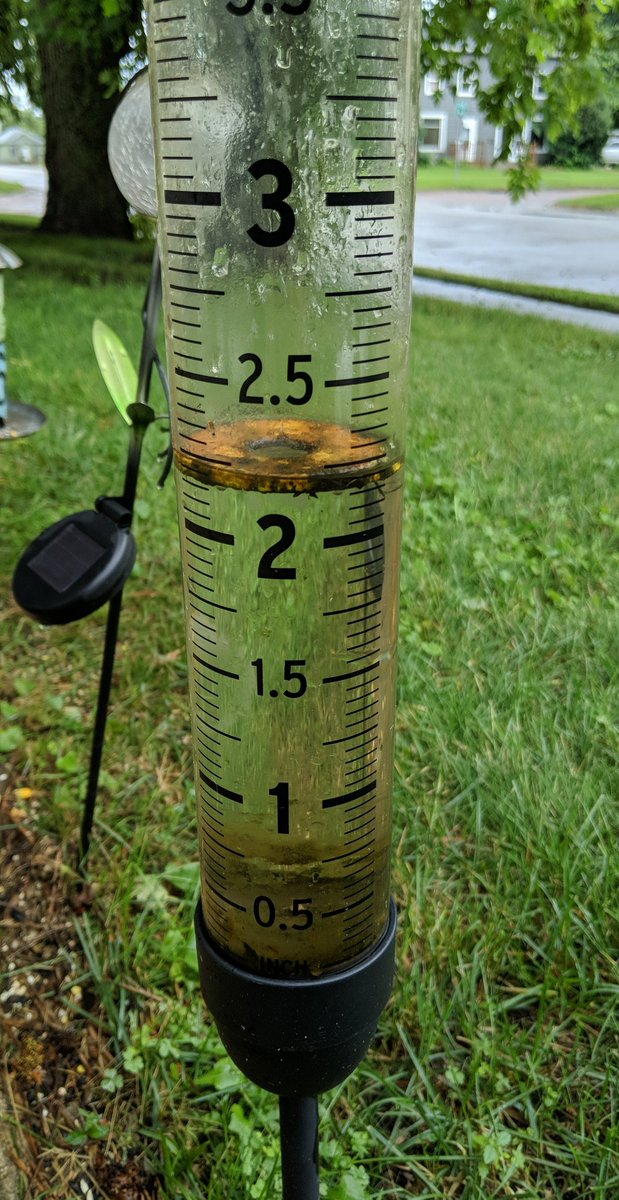
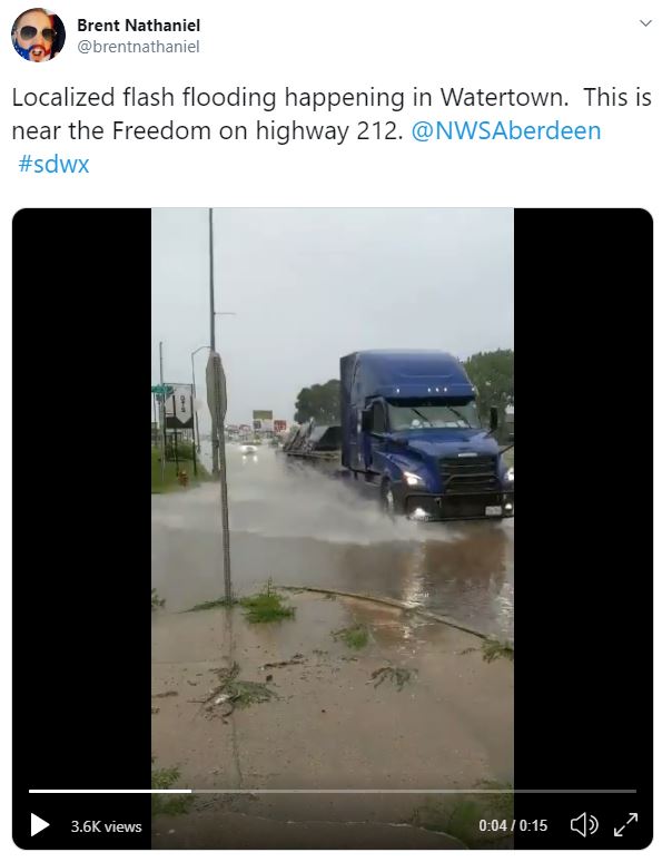
| Flooding at Blue Dog Lake. Photo by the Day County Sheriff | Rain gauge from Watertown, courtesy of Brent Nathaniel. A wide range of totals were observed with this event | Water over the roads in Watertown, courtesy of Brent Nathaniel | Ponding of water in Webster at the intersection of SD 25 and 14th Ave, courtesy of Daniel Basler Jr |
Radar
 |
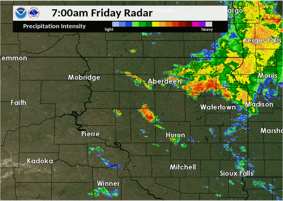 |
| Radar imagery from 1am to 7am 8-2-19 | Radar imagery from 7am to 1pm 8-2-19 |
 |
Media use of NWS Web News Stories is encouraged! Please acknowledge the NWS as the source of any news information accessed from this site. |
|

