
Widespread life-threatening flash and urban flooding continues in south-central Texas, with considerable flooding impacts possible across central Texas. Wildfire smoke is impacting air quality across much of the Great Lakes region into southern New England and the Mid-Atlantic. Monsoonal thunderstorms may produce isolated to scattered flash flooding across the Southwest into the Great Basin. Read More >
Overview
|
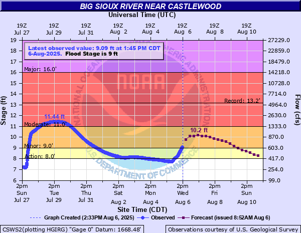
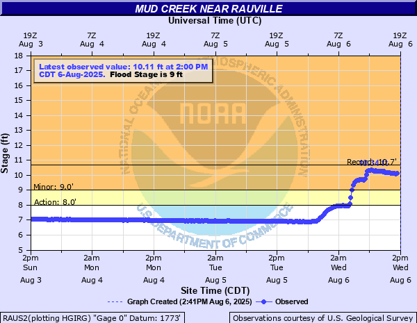
A low pressure system and a hot humid air mass would combine and be the focus for severe weather on August 5. A cluster of storms would first develop over south central North Dakota and then slide south into parts of north central and northeast South Dakota. These storms would produce a brief tornado near Leola, SD. The tornado would only be on the ground for a few seconds in an open field. In the Hoven and Bowdle areas, hail up to the size of baseballs would fall. The north side of Aberdeen would also have several large tree branches come down due to wind. Later in the evening the storms would form a line, producing pockets of strong staightline winds and dropping heavy rain across the region. The strongest winds would occur in the Lake Kampeska, Watertown and Waverly areas. A personal weather station on the south side of the lake would record a 99 mph wind gust. Many reports of trees uprooted or snapped at the trunk were relayed. It was estimated that 40+ pine trees were uprooted. There was also structural damage to grain bins and outbuildings. Flooding would also occur. Several rounds of heavy rain in late June and July had previously saturated soils. Another 2 to 4 inches of rain would fall on August 5 and would again cause rising rivers and overland flooding over northeast South Dakota. Water flowing across highways would require barricading by highway departments. |
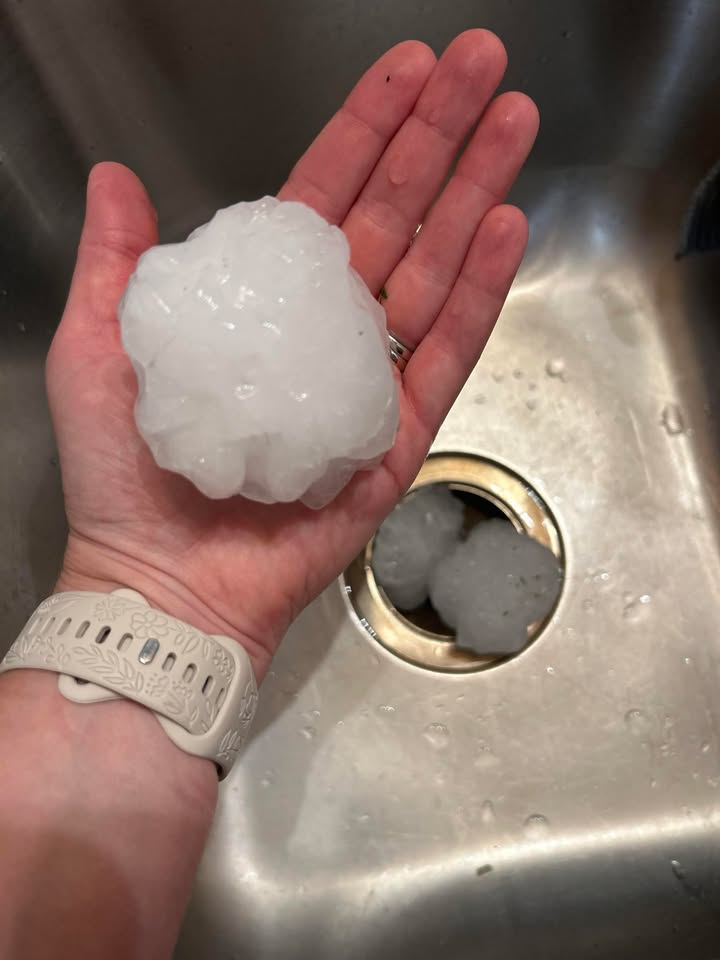 Tennis ball sized hail in Hoven. Photo courtesy of Ashley Griese |
Wind & Hail
Wind
 |
 |
 |
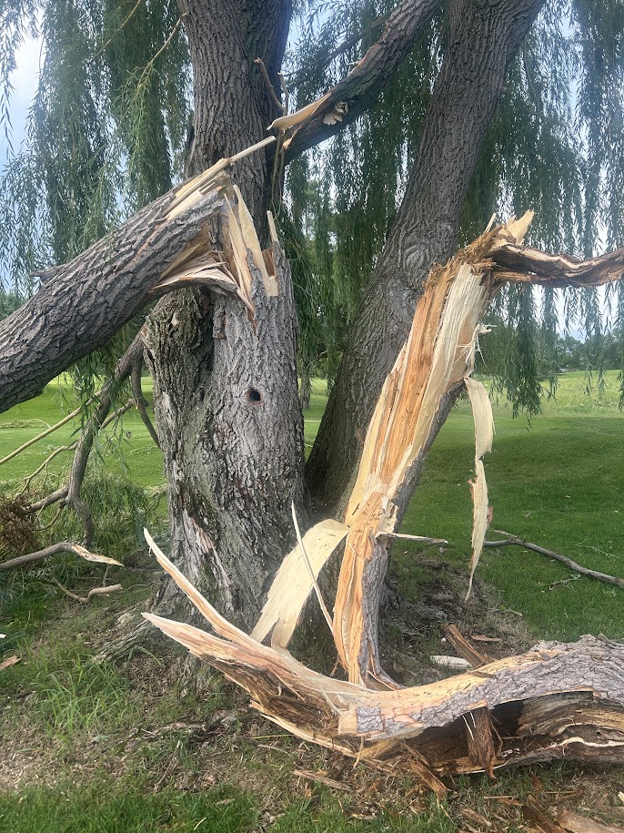 |
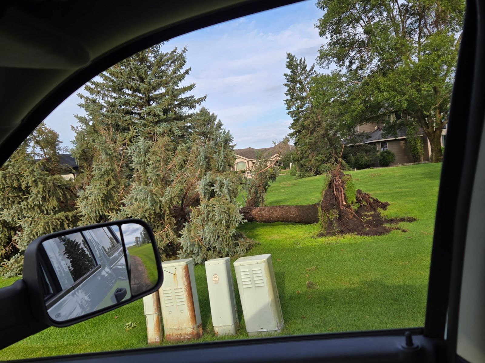
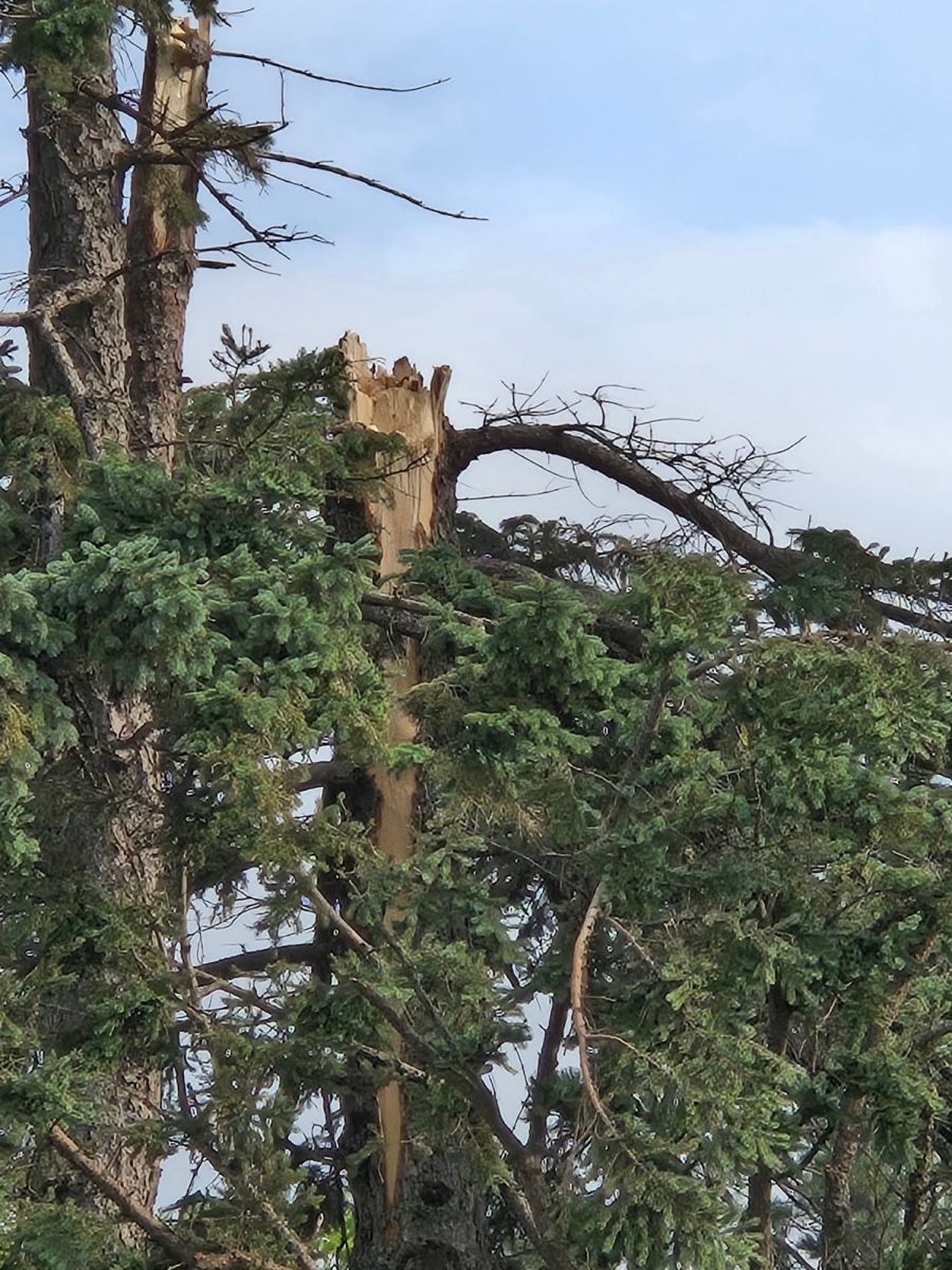
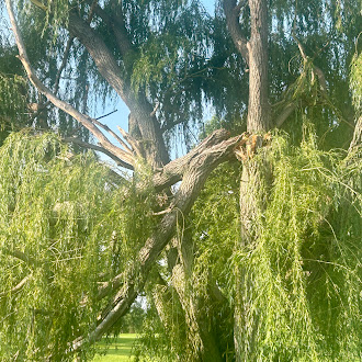
| Uprooted tree near Lake Kampeska, courtesy of Codington County Emergency Manager | Snapped tree near Lake Kampeska, courtesy of Codington County Emergency Manager | Snapped tree branches at Lee Park in Aberdeen, courtesy of Charlie Kornman | Snapped tree branches at Lee Park in Aberdeen, courtesy of Charlie Kornman |
Hail
 |
 |
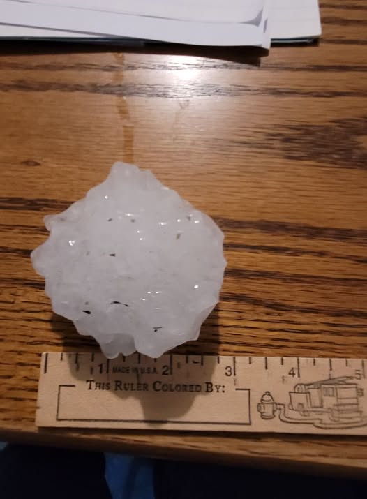 |
| Golf ball sized hail 10 miles south of Bowdle, courtesy of Edmunds County Emergency Manager | Baseball sized hail 10 miles south of Bowdle, courtesy of Edmunds County Emergency Manager | Tea cup sized hail in Hoven, photo courtesy of Anna Marshall |
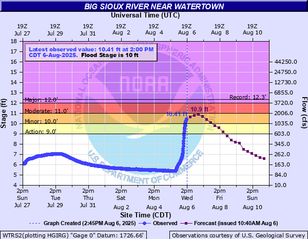
Flooding
Hydrographs
 |
 |
 |
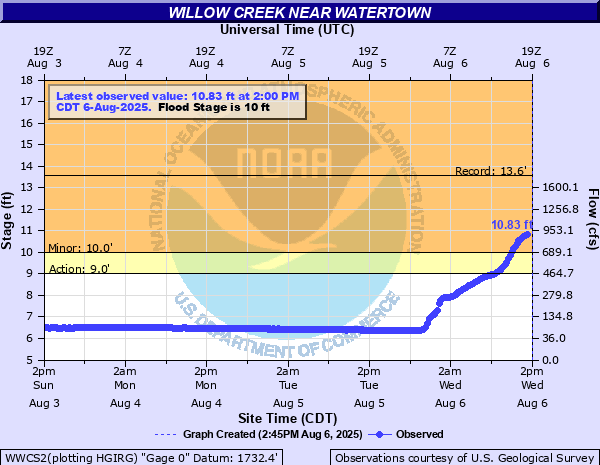 |
| Hydrograph from the Big Sioux River near Castlewood | Hydrograph from Mud Creek near Rauville | Hydrograph from the Big Sioux River near Watertown | Hydrograph from Willow Creek near Watertown |
Maps/Photos
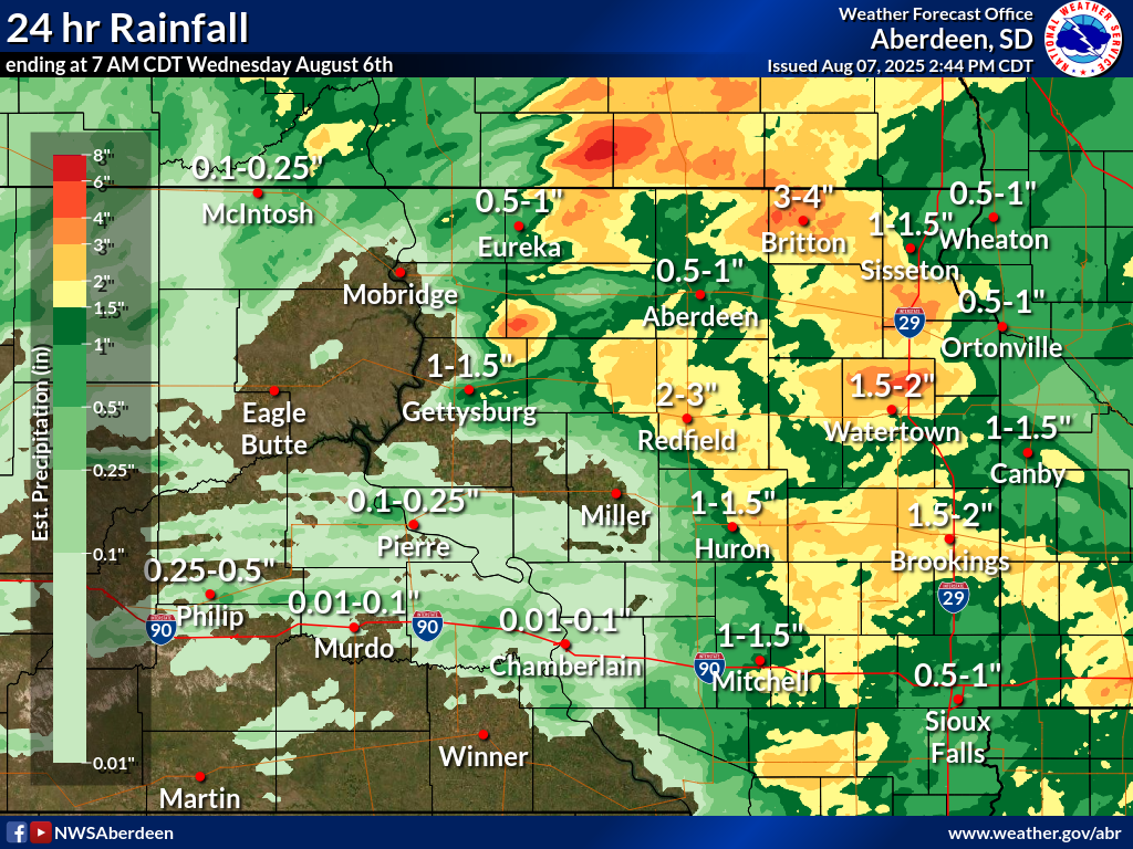 |
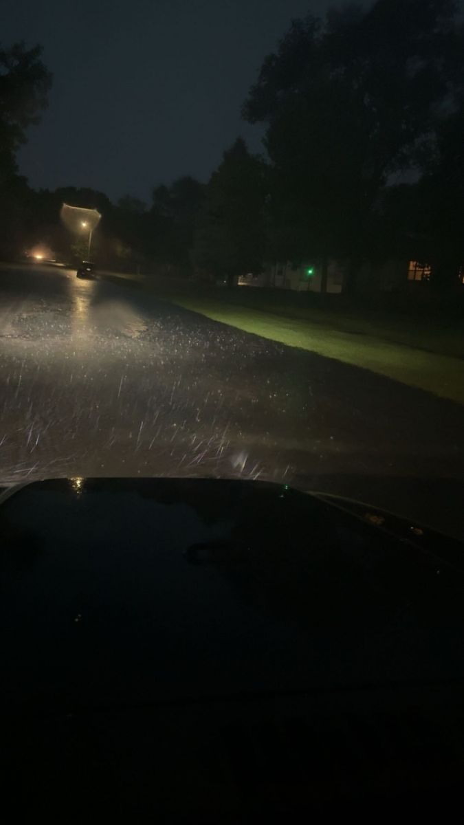 |
| 24 hour Rainfall total ending at 7 AM CDT August 6th | Street flooding in Britton, photo courtesy of Marshall County Emergency Manager |
Storm Reports
Preliminary Local Storm Report...Summary
National Weather Service Aberdeen SD
302 PM CDT Wed Aug 6 2025

..TIME...   ...EVENT...      ...CITY LOCATION...     ...LAT.LON...
..DATE...   ....MAG....      ..COUNTY LOCATION..ST.. ...SOURCE....
            ..REMARKS..

0434 PM     Hail             Elm Lake                45.89N 98.70W
08/05/2025  E1.00 Inch       Brown              SD   Public

            Quarter size hail reported in Elm Lake. Time
            estimated by radar.

0439 PM     Hail             2 NE Elm Lake           45.91N 98.68W
08/05/2025  E1.50 Inch       Brown              SD   Public

            Report from mPING: Ping Pong Ball (1.50
            in.).

0644 PM     Hail             5 WNW Long Lake         45.88N 99.31W
08/05/2025  M0.88 Inch       McPherson          SD   Public


0644 PM     Tstm Wnd Gst     5 W Long Lake           45.85N 99.32W
08/05/2025  E60 MPH          McPherson          SD   Trained Spotter

            Estimated 50 to 60 mph winds.

0720 PM     Hail             7 SW Long Lake          45.78N 99.29W
08/05/2025  E1.00 Inch       McPherson          SD   Public

            Estimated pea to quarter size hail for 30
            minutes to an hour. Measured 3.5 inches of
            rainfall. Some crop and garden damage from
            the hail.

0734 PM     Hail             3 NW Bristol            45.38N 97.79W
08/05/2025  E0.88 Inch       Day                SD   Storm Chaser

            Dime to nickel size hail. Estimated 45-50
            mph winds.

0748 PM     Funnel Cloud     6 E Hosmer              45.61N 99.36W
08/05/2025                   McPherson          SD   Public


0748 PM     Hail             5 W Webster             45.34N 97.62W
08/05/2025  M1.50 Inch       Day                SD   Trained Spotter


0754 PM     Tornado          2 WSW Leola             45.71N 98.98W
08/05/2025                   McPherson          SD   Fire Dept/Rescue

            Preliminary information. Location estimated
            by report and radar.

0815 PM     Hail             10 S Bowdle             45.31N 99.66W
08/05/2025  E2.75 Inch       Edmunds            SD   Emergency Mngr

            Golf ball to baseball size hail reported.

0837 PM     Hail             Wetonka                 45.62N 98.77W
08/05/2025  E1.50 Inch       McPherson          SD   Trained Spotter


0840 PM     Tstm Wnd Gst     4 SW Hillhead           45.80N 97.45W
08/05/2025  M65 MPH          Marshall           SD   Mesonet

            Mesonet station MRLS2 Hillhead 3 WSW. Radar
            estimated time.

0850 PM     Hail             6 W Hoven               45.25N 99.89W
08/05/2025  E1.00 Inch       Walworth           SD   Trained Spotter

            penny to quarter size hail.

0850 PM     Tstm Wnd Gst     Lake City               45.72N 97.42W
08/05/2025  M73 MPH          Marshall           SD   Mesonet

            Mesonet station 2 Lake City (SDDOT).

0900 PM     Hail             10 S Bowdle             45.31N 99.66W
08/05/2025  E1.75 Inch       Edmunds            SD   Emergency Mngr


0905 PM     Tstm Wnd Dmg     1 NW Aberdeen           45.48N 98.50W
08/05/2025                   Brown              SD   Public

            Multiple large tree branches down at Lee
            Park golf course.

0915 PM     Tstm Wnd Gst     2 ENE Aberdeen          45.48N 98.45W
08/05/2025  M70 MPH          Brown              SD   Mesonet

            Personal Weather Station.

0920 PM     Flash Flood      Britton                 45.79N 97.75W
08/05/2025                   Marshall           SD   Emergency Mngr

            Street flooding and water over the curbs in
            Britton.

0920 PM     Hail             4 ENE Hoven             45.26N 99.69W
08/05/2025  E1.00 Inch       Edmunds            SD   Public

            Corrects previous hail report from 4 ENE
            Hoven.

0920 PM     Hail             Hoven                   45.24N 99.78W
08/05/2025  M1.50 Inch       Potter             SD   Public

            Image sent via social media, radar estimated
            time.

0920 PM     Hail             Hoven                   45.24N 99.78W
08/05/2025  M3.00 Inch       Potter             SD   Public

            Photo with ruler reference sent via social
            media.

0920 PM     Hail             Hoven                   45.24N 99.78W
08/05/2025  E2.50 Inch       Potter             SD   Public

            Photo send via social media.

0920 PM     Tstm Wnd Gst     7 NNE Pickerel Lake Sta 45.59N 97.22W
08/05/2025  E60 MPH          Roberts            SD   Public

            Estimated 60 mph winds and small branches
            broke off of trees. Radar estimated time.

0945 PM     Hail             3 SSE Hoven             45.20N 99.75W
08/05/2025  E1.50 Inch       Potter             SD   Public

            Hail size estimated by observer and the hail
            caused some minor damage to their corn crop.

0945 PM     Tstm Wnd Dmg     2 ESE Groton            45.44N 98.07W
08/05/2025                   Brown              SD   Trained Spotter

            Hay bales tossed from north to south across
            the highway. Radar estimated time.

0946 PM     Funnel Cloud     6 E Verdon              45.25N 97.97W
08/05/2025                   Day                SD   Public


1019 PM     Tstm Wnd Gst     Tolstoy                 45.20N 99.61W
08/05/2025  M53 MPH          Potter             SD   Mesonet

            Mesonet station 56 Tolstoy (SDDOT).

1044 PM     Tstm Wnd Gst     5 E Orient              44.90N 98.98W
08/05/2025  M66 MPH          Hand               SD   Mesonet

            Mesonet station 158 Miranda (SDDOT).

1049 PM     Tstm Wnd Gst     2 NE Sandy Shore State  44.91N 97.22W
08/05/2025  M99 MPH          Codington          SD   Mesonet

            Personal weather station peak gust.

1050 PM     Tstm Wnd Dmg     2 W Watertown Airport   44.91N 97.21W
08/05/2025                   Codington          SD   Emergency Mngr

            Multiple uprooted trees up along Kampeska.
            Time radar estimated.

1050 PM     Tstm Wnd Gst     1 SE Watertown Airport  44.90N 97.15W
08/05/2025  M68 MPH          Codington          SD   ASOS

            ASOS station KATY Watertown Muni AP.

1055 PM     Tstm Wnd Dmg     5 NNE Thomas            44.83N 97.17W
08/05/2025                   Codington          SD   Trained Spotter

            Two hay bales rolled over 100 ft across a
            field.

1056 PM     Tstm Wnd Dmg     4 NNE Thomas            44.81N 97.17W
08/05/2025                   Codington          SD   Trained Spotter

            Numerous tree branches blown at least 90
            feet into a field. The largest branches
            knocked down were around 6 inches in
            diameter.

1103 PM     Tstm Wnd Dmg     Waverly                 45.00N 96.97W
08/05/2025                   Codington          SD   Emergency Mngr

            Multiple trees were snapped at the top in
            town and there was an empty grain bin blown
            open near town.

1135 PM     Tstm Wnd Gst     4 W Bryant              44.59N 97.55W
08/05/2025  M59 MPH          Clark              SD   Mesonet

            Mesonet station 262 4W Bryant (SDDOT).

1157 PM     Tstm Wnd Gst     4 ESE Lake Norden       44.55N 97.14W
08/05/2025  M71 MPH          Hamlin             SD   Mesonet

            Personal Weather Station.

1201 AM     Tstm Wnd Gst     1 N Ree Heights         44.53N 99.20W
08/06/2025  M65 MPH          Hand               SD   Mesonet

            Mesonet station 312 Ree Heights (SDDOT).

1204 AM     Tstm Wnd Gst     1 SE Toronto            44.56N 96.63W
08/06/2025  M60 MPH          Deuel              SD   Trained Spotter

            Estimated winds. Trees bent over and fallen
            branches.

0200 AM     Flash Flood      3 W Troy                45.04N 96.93W
08/06/2025                   Codington          SD   Emergency Mngr

            Water up to ditches and bottoms of bridges
            on main highways, water over secondary
            roads.

0200 AM     Flash Flood      3 NNE Agency Village    45.60N 97.04W
08/06/2025                   Roberts            SD   Emergency Mngr

            County department barricaded several
            locations where water ran over highways and
            secondary roads, including 123rd street and
            highway 15.

0200 AM     Flash Flood      1 ENE Wilmot            45.41N 96.83W
08/06/2025                   Roberts            SD   Emergency Mngr

            County department barricaded several
            locations where water ran over highways and
            secondary roads, including 123rd street and
            highway 15.

0600 AM     Rain             La Bolt                 45.05N 96.67W
08/06/2025  M3.16 Inch       Grant              SD   Cocorahs

            24 hour total ending at 6 AM.

0700 AM     Rain             1 W Claremont           45.67N 98.04W
08/06/2025  M2.36 Inch       Brown              SD   Cocorahs

            24 hour total ending at 7 AM.

0700 AM     Rain             4 W Henry               44.88N 97.54W
08/06/2025  M2.06 Inch       Clark              SD   Cocorahs

            24 hour total ending at 7 AM.

0700 AM     Rain             5 NNE Tolstoy           45.27N 99.58W
08/06/2025  M2.05 Inch       Edmunds            SD   Cocorahs

            24 hour total ending at 7 AM.

0700 AM     Rain             4 W Chelsea             45.17N 98.82W
08/06/2025  M2.13 Inch       Faulk              SD   Cocorahs

            24 hour total ending at 7 AM.

0700 AM     Rain             2 S Stockholm           45.07N 96.80W
08/06/2025  M2.38 Inch       Grant              SD   Cocorahs

            24 hour total ending at 7 AM.

0700 AM     Rain             Britton                 45.79N 97.75W
08/06/2025  M2.32 Inch       Marshall           SD   CO-OP Observer

            24 hour total ending at 7 AM.

0700 AM     Rain             1 SSE Kidder            45.87N 97.70W
08/06/2025  M3.31 Inch       Marshall           SD   Cocorahs

            24 hour total ending at 7 AM.

0700 AM     Rain             1 W Summit              45.30N 97.06W
08/06/2025  M2.56 Inch       Roberts            SD   CO-OP Observer

            24 hour total ending at 7 AM.

0800 AM     Rain             1 E Pickerel Lake Stati 45.51N 97.26W
08/06/2025  M2.14 Inch       Day                SD   Cocorahs

            24 hour total ending at 8 AM.

0800 AM     Rain             3 WSW Long Lake         45.84N 99.26W
08/06/2025  M2.20 Inch       McPherson          SD   Cocorahs

            24 hour total ending at 8 AM.

0800 AM     Rain             Wilmot                  45.41N 96.86W
08/06/2025  M3.63 Inch       Roberts            SD   CO-OP Observer

            24 hour rainfall total ending at 8 am.

0900 AM     Rain             8 NNE Wilmot            45.52N 96.79W
08/06/2025  E2.78 Inch       Roberts            SD   Cocorahs

            24 hour total ending at 9 AM.
Radar
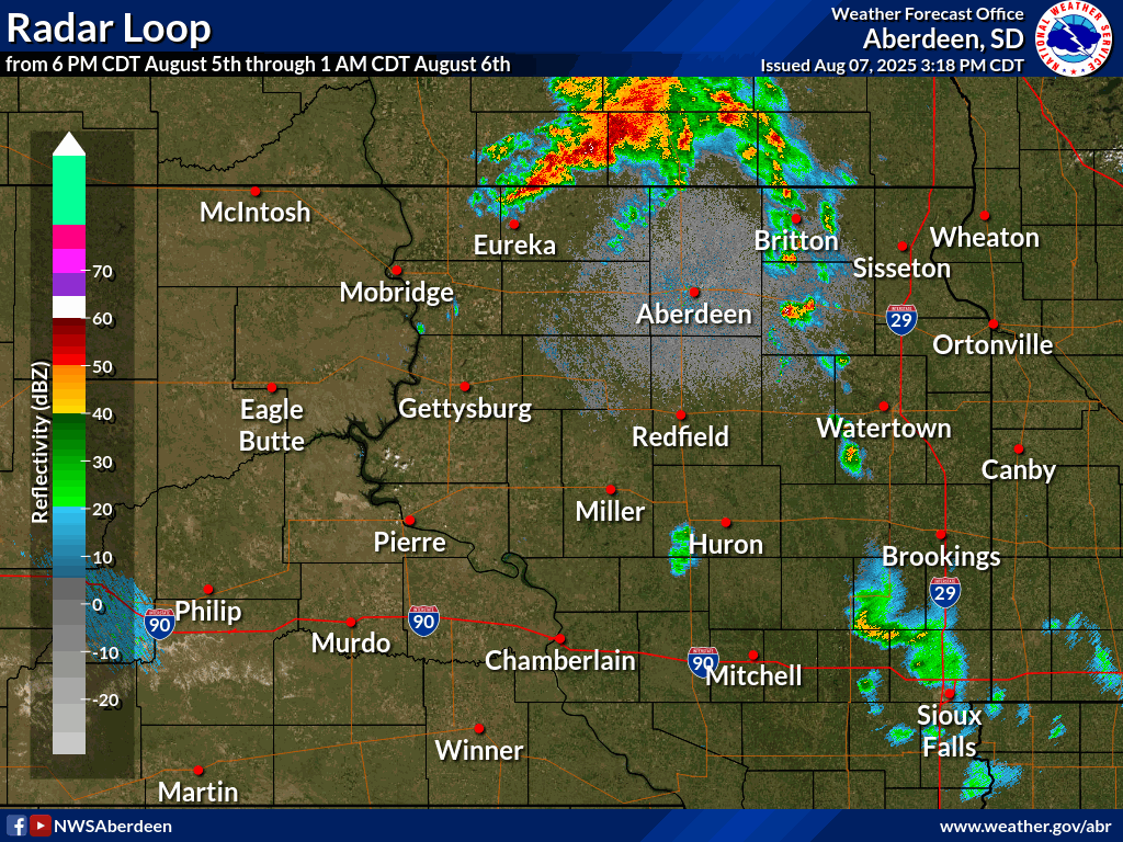 |
| Radar Loop from 6 PM CDT August 5th to 1 AM CDT August 6th |
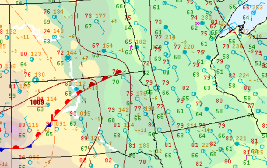
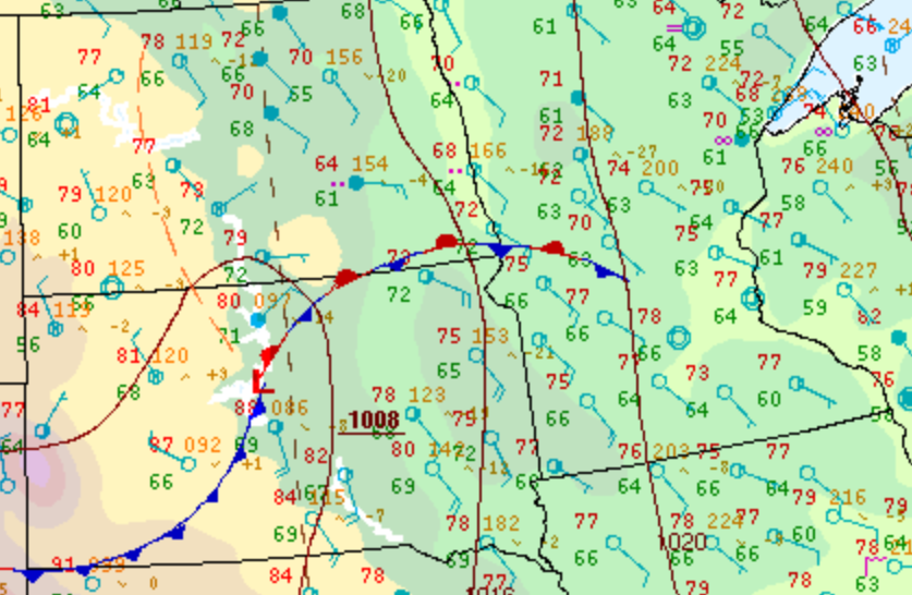
Environment
Surface Pressure Pattern
 |
 |
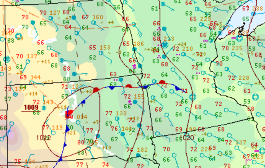 |
| WPC Surface Analysis at 4 PM CDT August 5th | WPC Surface Analysis at 7 PM CDT August 5th | WPC Surface Analysis at 10 PM CDT August 5th |
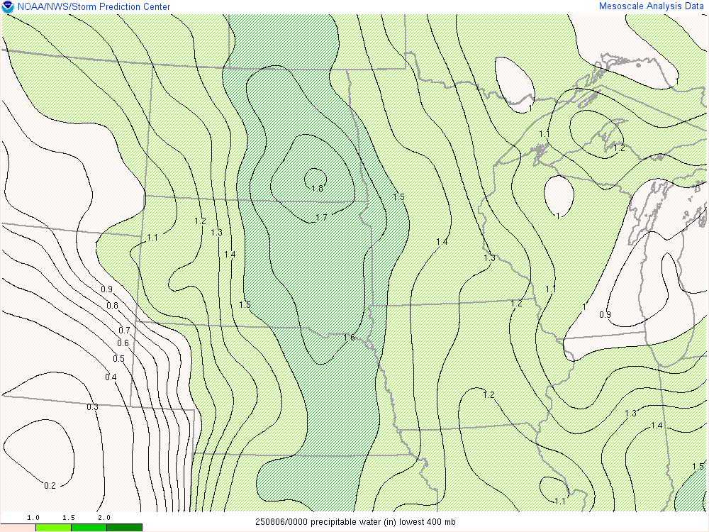
Near-storm environment at 7 PM CDT August 5th
 |
 |
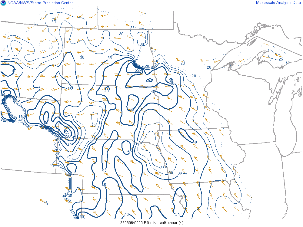 |
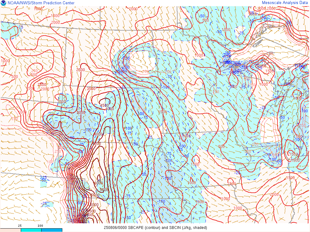
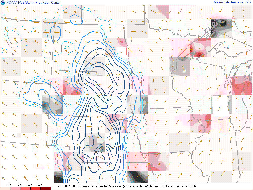
| SPC Surface Based CAPE | SPC Supercell Composite Parameter | SPC Effective Bulk Shear |
 |
 |
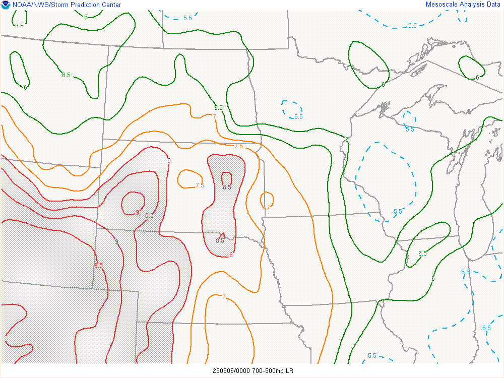 |
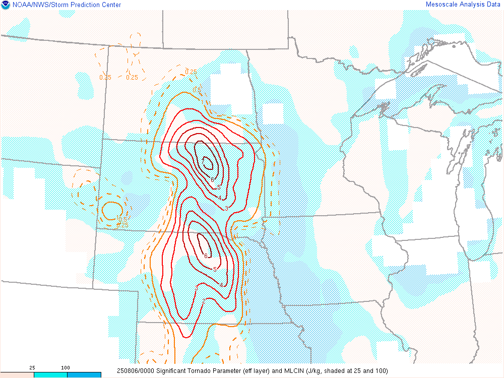
| SPC Significant Tornado Parameter | SPC Precipitable Water | SPC Mid Level Lapse Rates |
 |
Media use of NWS Web News Stories is encouraged! Please acknowledge the NWS as the source of any news information accessed from this site. |
|

