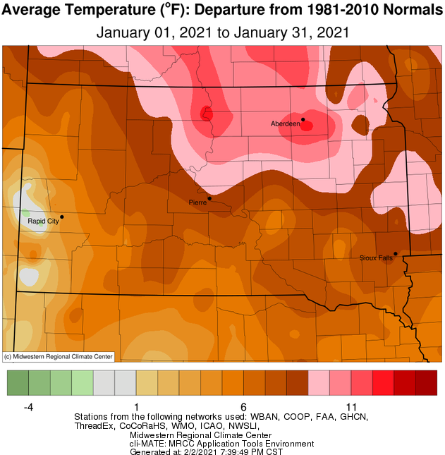
January 2021 finished well above normal temperature-wise as a whole, between 8 and 13 degrees for most. In fact, Kennebec recorded their 10th warmest January on record; Watertown 7th, Timber Lake 5th, Aberdeen, Pierre and Sisseton 4th, and Mobridge 2nd (the top two warmest Januaries at most locations were 2006 and 1990). Looking at the warmth another way, a number of locations failed to drop below zero degrees all month long. This includes Pierre (has happened only 5 other years on record, and the average is 9 sub-zero days per January), Timber Lake (3 other years, averages 12 sub-zero days), Aberdeen (two other years – 2006 and 1990, average is 14 sub-zero days), Sisseton (one other year – 2006, averages 13 days), Mobridge (one other year – 2006, averages 13 days) and Watertown (one other year – 2006, averages 14 days). A number of daily warm low temperature records were set at several locations, particularly on the 13th and 14th.
Looking at the winter more broadly, this mild January picked up where the mild December left off. With two-thirds of meteorological winter (Dec, Jan and Feb) now finished, Watertown has recorded their 5th warmest winter to date on record, 3rd at Pierre and Sisseton, 2nd at Kennebec and Aberdeen, and 1st at Timber Lake and Mobridge. Unfortunately, one of the side-effects of such a mild winter is thin ice on area lakes – there were several incidences of people falling through.
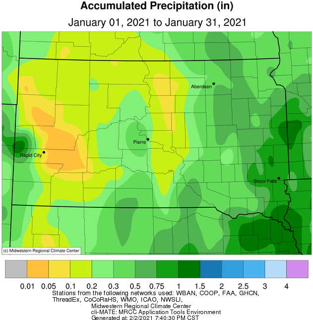
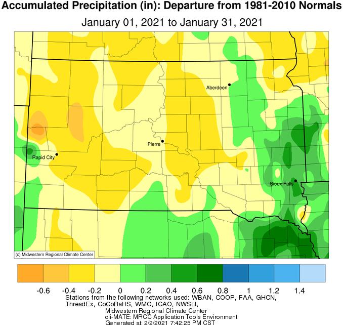
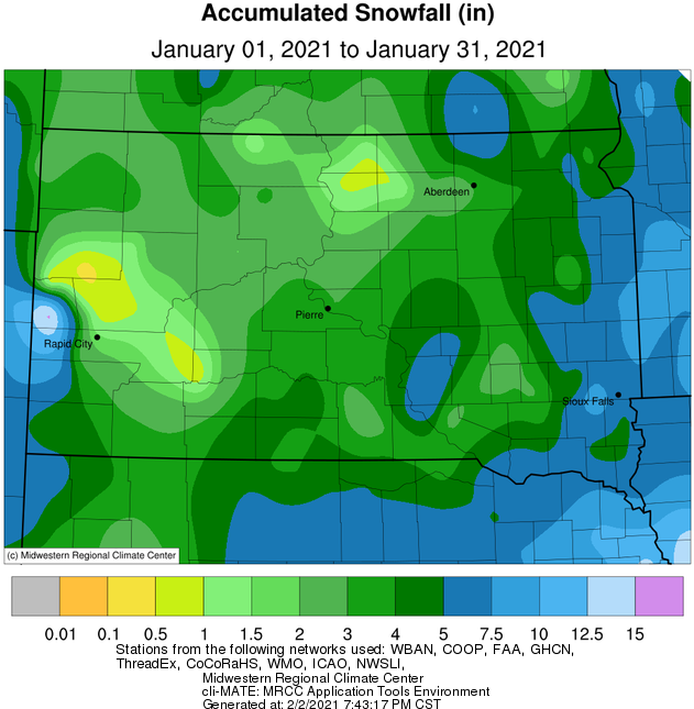
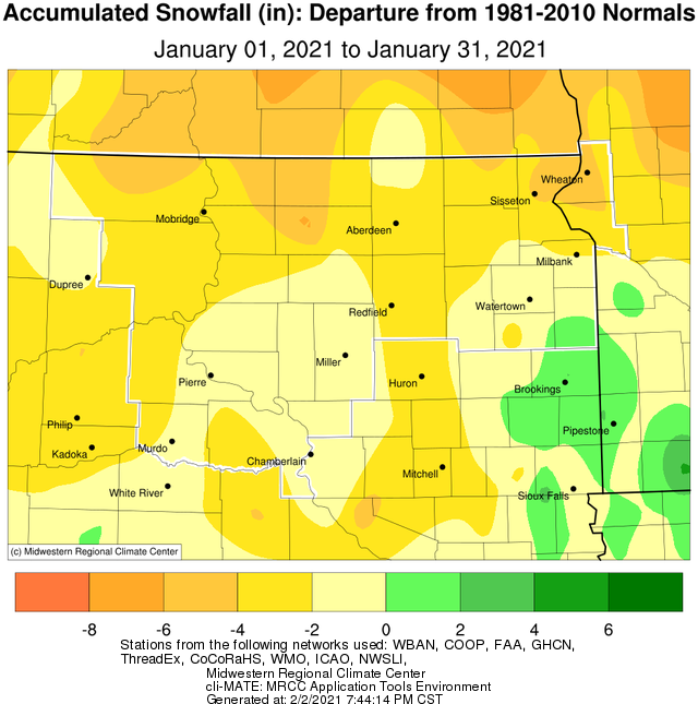
In terms of precipitation, January 2021 finished below average both in terms of snowfall and liquid equivalent for the vast majority of the area. While a couple daily snowfall records were set on the 23rd at Watertown and Pierre, amounts were under 2” in both cases. The main storm system this January manifested in the form of high winds across the entire forecast area, as well as blizzard conditions across portions of eastern South Dakota on the 14th and 15th. Much more information on this event can be found here: https://www.weather.gov/abr/2021_January_14-15_BlizzardHighWind
|
January 2021 |
||||
|
Temperature Data |
Aberdeen |
Sisseton |
*Wheaton |
Watertown |
|
Warmest Temperature / Date |
49 / 20th |
49 / 13th |
M |
44 / 13th |
|
Coldest Temperature / Date |
1 / 24th |
2 / 27th |
M |
1 / 22nd |
|
Average High / Departure from Normal |
33.1 / +10.6 |
31.1 / +8.1 |
M |
29.2 / +7.0 |
|
Average Low / Departure from Normal |
17.0 / +15.5 |
17.5 / +14.2 |
M |
15.3 / +12.2 |
|
Monthly Average / Departure from Normal |
25.1 / +13.1 |
24.3 / +11.2 |
M |
22.2 / +9.5 |
|
Precipitation Data |
|
|
|
|
|
Monthly Precipitation / Departure from Normal |
0.52 / +0.05 |
0.45 / +0.02 |
0.44 / -0.38 |
0.54 / +0.02 |
|
Most Precipitation in 24 hours / Date |
0.16 / 6th |
0.11 / 13th |
0.16 / 15th |
0.12 / 13,14th |
|
Monthly Snowfall / Departure from Normal |
3.0 / -3.4 |
3.1 / -5.3 |
3.9 / -5.1 |
4.9 / -0.4 |
|
Most Snow in 24 hours / Date |
1.7 / 23rd |
1.4 / 14th |
1.5 / 15th |
1.8 / 23rd |
|
Temperature Data |
Pierre |
Kennebec |
Mobridge |
Timber Lake |
|
Warmest Temperature / Date |
54 / 12, 13th |
55 / 13th |
55 / 12th |
51 / 12th |
|
Coldest Temperature / Date |
0 / 24th |
-5 / 26th |
4 / 24th |
1 / 28th |
|
Average High / Departure from Normal |
37.5 / +7.5 |
37.3 / +5.4 |
37.0 / +11.0 |
34.5 / +6.4 |
|
Average Low / Departure from Normal |
20.3 / +10.5 |
19.8 / +9.7 |
20.7 / +14.6 |
18.8 / +11.0 |
|
Monthly Average / Departure from Normal |
28.9 / +9.0 |
28.8 / +7.8 |
28.9 / +12.9 |
27.0 / +9.0 |
|
Precipitation Data |
|
|
|
|
|
Monthly Precipitation / Departure from Normal |
0.20 / -0.22 |
0.14 / -0.25 |
0.18 / -0.11 |
0.17 / -0.26 |
|
Most Precipitation in 24 hours / Date |
0.13 / 23rd |
0.05 / 18th |
0.07 / 18th |
0.06 / 18th |
|
Monthly Snowfall / Departure from Normal |
3.0 / -1.7 |
2.9 / -1.9 |
1.3 / -3.7 |
3.3 / -2.3 |
|
Most Snow in 24 hours / Date |
1.7 / 23rd |
1.2 / 23rd |
0.8 / 25th |
1.2 / 26th |
*Wheaton: temperature data for the second half of the month is missing due to data quality issues.
January 2021 temperature departures from normal, courtesy of the Midwestern Regional Climate Center
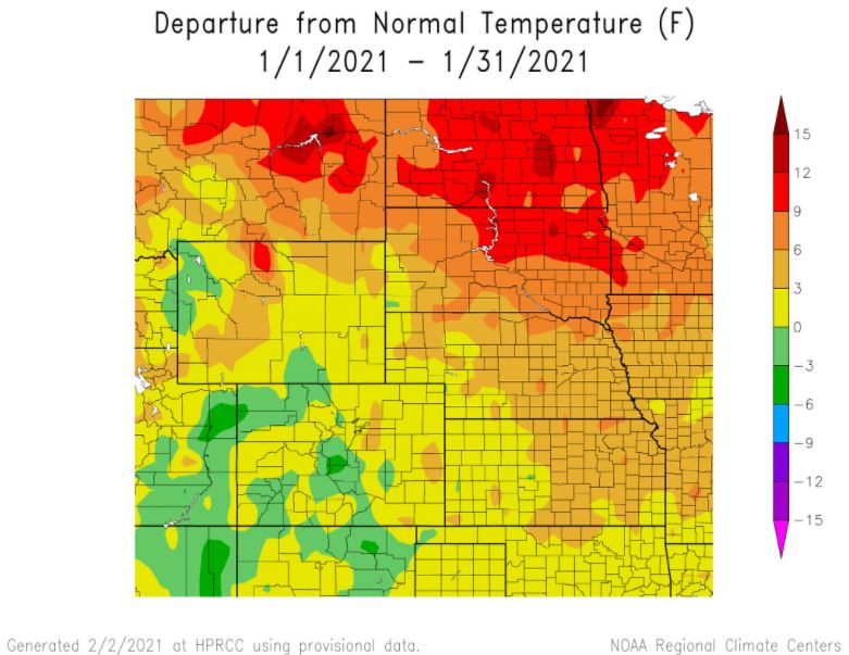
January 2021 temperature departures from normal on a regional scale, courtesy of the High Plains Regional Climate Center
January 2021 total precipitation (left) and departure from normal (right), courtesy of the Midwestern Regional Climate Center
January 2021 total snowfall (left) and departure from normal (right), courtesy of the Midwestern Regional Climate Center
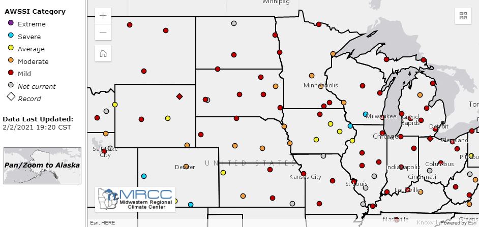
The Accumulated Winter Season Severity Index through early February, from the Midwestern Regional Climate Center. This index shows how severe the winter has been thus far. Most of our area is in the "Mild" category, with some in the "Moderate" category.
Specific plots of the Accumulated Winter Season Severity Index at Aberdeen, Pierre and Watertown (from top to bottom, respectively)
.jpeg)
.jpeg)
.jpeg)

