Widespread life-threatening flash and urban flooding continues in south-central Texas, with considerable flooding impacts possible across central Texas. Wildfire smoke is impacting air quality across much of the Great Lakes region into southern New England and the Mid-Atlantic. Monsoonal thunderstorms may produce isolated to scattered flash flooding across the Southwest into the Great Basin. Read More >
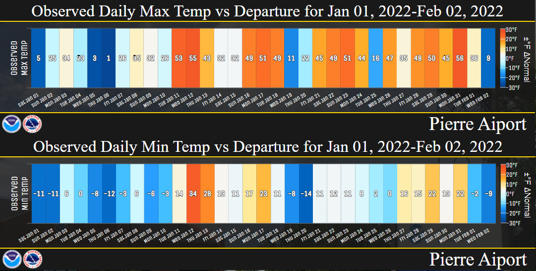
January 2022 finished near to above average across central South Dakota by as much as 2 degrees, but below average roughly along and east of the James River Valley by as much as 8 degrees. Generally speaking, locations further northeast were colder and locations further southwest were warmer. Temperatures could vary quite a bit this month from day to day however. Pierre, for instance, recorded 4 days with a low temperature of 10 below or colder (this is average for January). Pierre also recorded 15 days with a high temperature of 40 degrees or warmer, the most since 2006 (average is 8). This combination has only happened in one other January on record (1942). These numerous temperature swings were due to a parade of clipper-like low pressure systems which moved from northwest to southeast across the region, which drew warm air out ahead of them and brought cold air quickly in behind. The blasts of cold air were on numerous occasions bitterly to dangerously cold, with wind chills from 20 to well into the 40 below zero range, particularly across northeastern SD and west central MN.
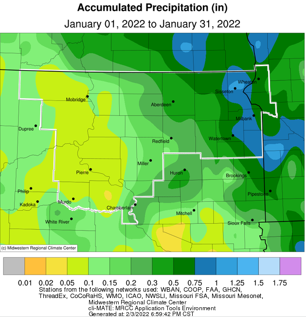
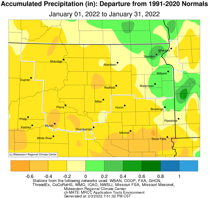
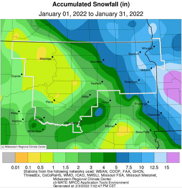
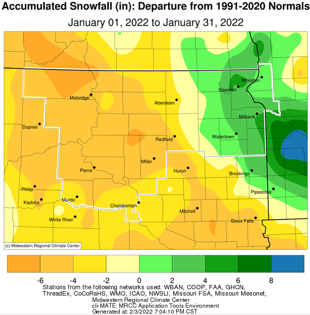
Precipitation varied about as much as temperatures did across the region. The Prairie Coteau and west central Minnesota area observed near to above average precipitation and snowfall, while those across and west of the James River Valley had below to much below average amounts. The most significant snowstorm of the month took place on the 14th, and impacted much of northeastern South Dakota and west central Minnesota with as much as 4 to 9 inches of snow. Watertown recorded 5.4 inches, which set a daily record. Meanwhile, Timber Lake tied their 8th lowest January snowfall on record, Pierre tied 6th, and Kennebec and Mobridge tied their lowest amount of snow on record. The storm track largely repeated throughout the month, leading to this disparity. All areas experienced several rounds of windy conditions, however. When combined with generally light falling snow and pre-existing, vulnerable-to-blowing snowpack across portions of the Prairie Coteau into west central Minnesota, and there were several incidents of significant blowing snow. Blizzard conditions were observed from the 4th into the 5th in these areas.
|
January 2022 |
||||
|
Temperature Data |
Aberdeen |
Sisseton |
Wheaton |
Watertown |
|
Warmest Temperature / Date |
45 / 17th |
45 / 2, 18th |
37 / 18th |
41 / 18th |
|
Coldest Temperature / Date |
-21 / 1st |
-24 / 7th |
-24 / 1, 7th |
-17 / 1,2,6,25th |
|
Average High / Departure from Normal |
24.9 / +1.2 |
22.2 / -0.4 |
14.6 / -5.5 |
21.9 / +0.5 |
|
Average Low / Departure from Normal |
-1.7 / -3.6 |
-4.8 / -8.9 |
-7.9 / -10.6 |
-3.2 / -6.3 |
|
Monthly Average / Departure from Normal |
11.6 / -1.2 |
8.7 / -4.6 |
3.4 / -8.0 |
9.4 / -2.8 |
|
Precipitation Data |
|
|
|
|
|
Monthly Precipitation / Departure from Normal |
0.44 / -0.11 |
1.06 / +0.43 |
0.66 / -0.22 |
0.71 / +0.13 |
|
Most Precipitation in 24 hours / Date |
0.16 / 14th |
0.56 / 14th |
0.21 / 14th |
0.45 / 14th |
|
Monthly Snowfall / Departure from Normal |
5.5 / -2.3 |
10.5 / +4.3 |
7.8 / -0.2 |
8.3 / +1.6 |
|
Most Snow in 24 hours / Date |
2.4 / 14th |
5.7 / 14th |
2.6 / 14th |
5.4 / 14th |
|
Temperature Data |
Pierre |
Kennebec |
Mobridge |
Timber Lake |
|
Warmest Temperature / Date |
56 / 31st |
55 / 23rd |
52 / 30th |
51 / 30th |
|
Coldest Temperature / Date |
-14 / 20th |
-16 / 2nd |
-18 / 1st |
-21 / 6th |
|
Average High / Departure from Normal |
35.3 / +6.3 |
35.6 / +4.0 |
31.2 / +4.1 |
30.3 / +3.6 |
|
Average Low / Departure from Normal |
7.1 / -2.2 |
8.7 / -0.5 |
5.9 / -0.5 |
5.9 / -1.2 |
|
Monthly Average / Departure from Normal |
21.2 / +2.1 |
22.2 / +1.8 |
18.5 / +1.7 |
18.7 / +1.8 |
|
Precipitation Data |
|
|
|
|
|
Monthly Precipitation / Departure from Normal |
0.07 / -0.38 |
0.03 / -0.42 |
0.14 / -0.24 |
0.10 / -0.39 |
|
Most Precipitation in 24 hours / Date |
0.03 / 5th |
0.03 / 21st |
0.04 / 21st |
0.06 / 4th |
|
Monthly Snowfall / Departure from Normal |
0.3 / -4.8 |
0.0 / -5.5 |
T / -6.3 |
0.5 / -5.9 |
|
Most Snow in 24 hours / Date |
0.2 / 5th |
N/A |
T /Many days |
0.5 / 4th |
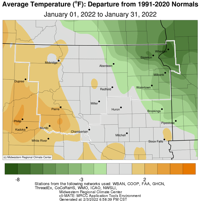
January 2022 temperature departure from the normal, courtesy of the Midwestern Regional Climate Center.
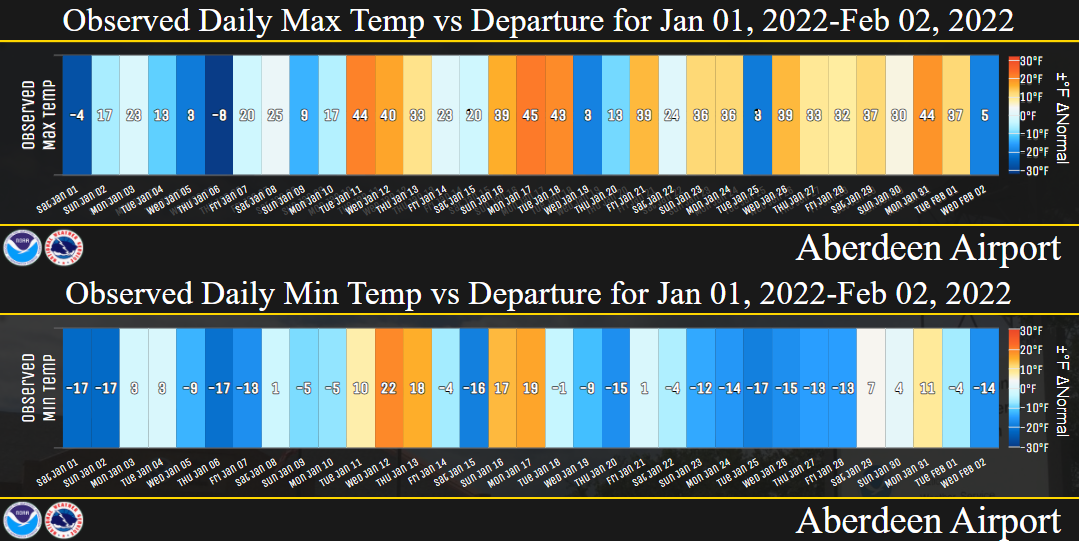
Daily high and low temperatures (text value) and departures from normal (color shading) for Aberdeen, highlighting the several drastic and quick fluctuations this month.
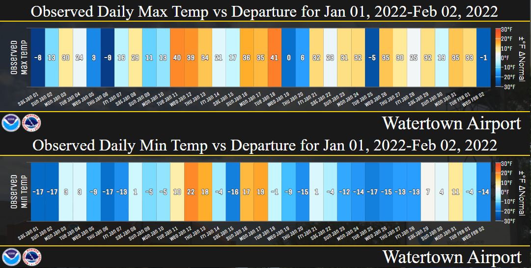
Daily high and low temperatures (text value) and departures from normal (color shading) for Watertown, highlighting the several drastic and quick fluctuations this month.
Daily high and low temperatures (text value) and departures from normal (color shading) for Pierre, highlighting the several drastic and quick fluctuations this month.
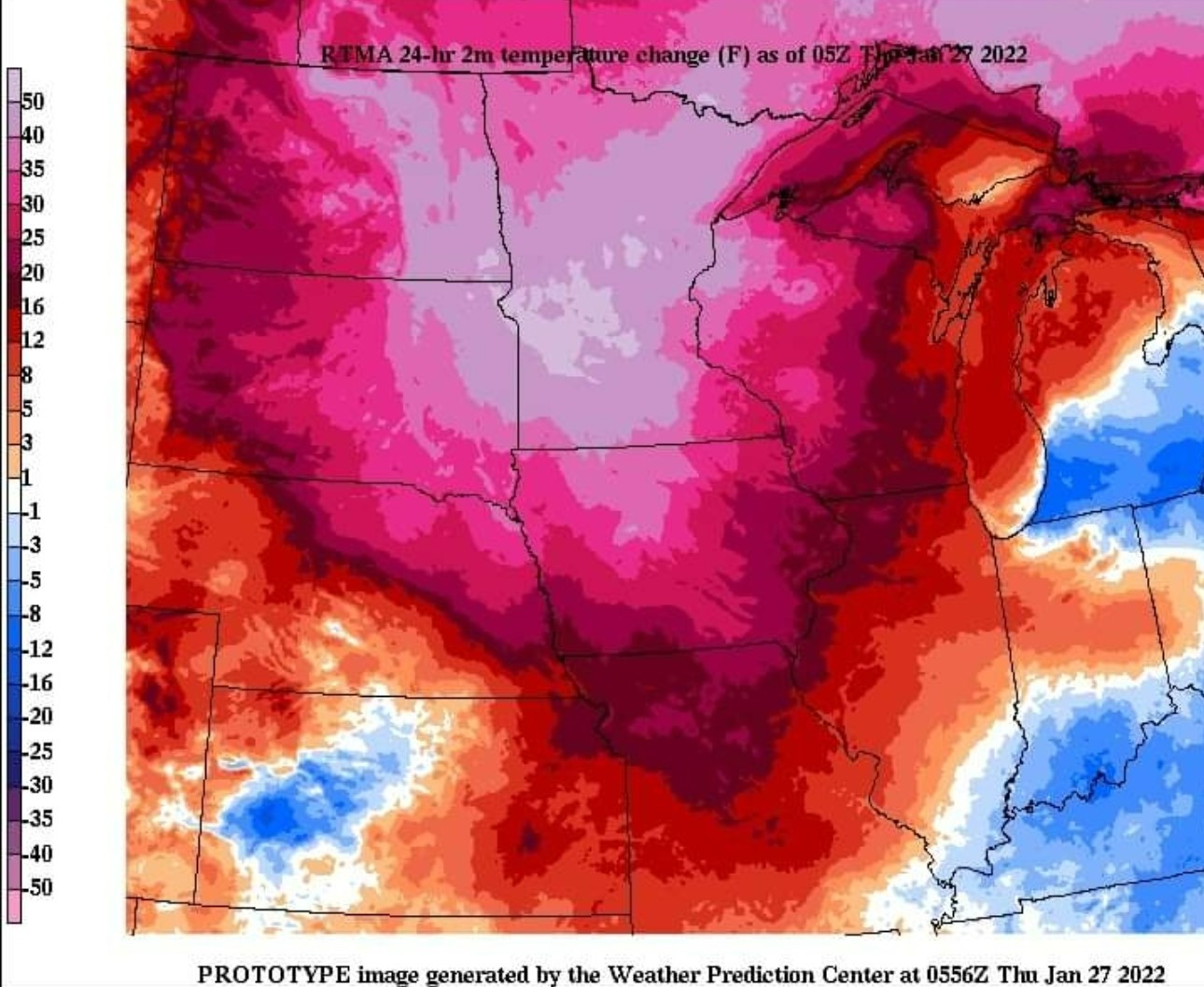
24 hour temperature change map, from midnight on the 26th to midnight on the 27th, across the Northern Plains. Sisseton recorded a low temperature of -19 F at 12:01am on the 26th, and then rebounded to a high of 38 F at 8:12pm. That's a 57 F temperature change in a little more than 20 hours! For comparison, on January 22nd, 1943 in Spearfish, SD, the temperature changed 58 degrees in just 27 minutes, from 54 F to -4 F! Find more on this historic event here.
January 2022 precipitation totals (left) and departures from normal (right), courtesy of the Midwestern Regional Climate Center.
January 2022 snowfall totals (left) and departures from normal (right), courtesy of the Midwestern Regional Climate Center.
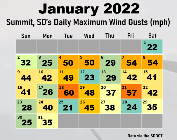
Daily maximum wind gusts at Summit, SD. Data from the SDDOT. Several clipper-like low pressure systems kept conditions breezy to windy most days this month.