Record setting heat is expected over the next several days from the Intermountain West through the northern Plains. Furthermore, fire weather concerns increase with dry and breezy conditions. Meanwhile, heavy rainfall and severe thunderstorm threats for the Ohio/Tennessee Valleys, central Appalachians and Southeast today. The threat shifts to central Gulf Coast and across central Texas this week. Read More >
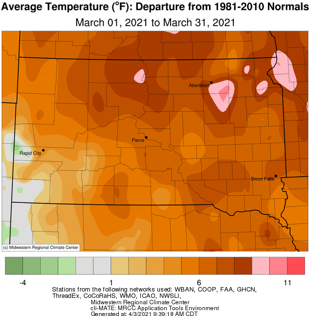
March 2021 was exceptionally mild, as many days featured high temperatures of 15 to 35 degrees above average in the 60s, 70s and 80s. Nighttime lows were occasionally near or even above average daytime highs as well. March 1-9th and 29th were particularly warm, breaking several daily record warm high and low temperatures across the area. On the whole, locations finished anywhere from 6 to 11 degrees above normal which made this the 9th warmest March on record at Watertown, 8th in Pierre, 7th in Wheaton, and 3rd in Mobridge, Timber Lake, Sisseton and Aberdeen.
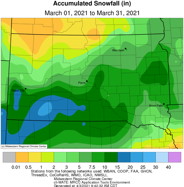
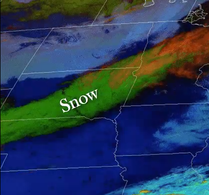
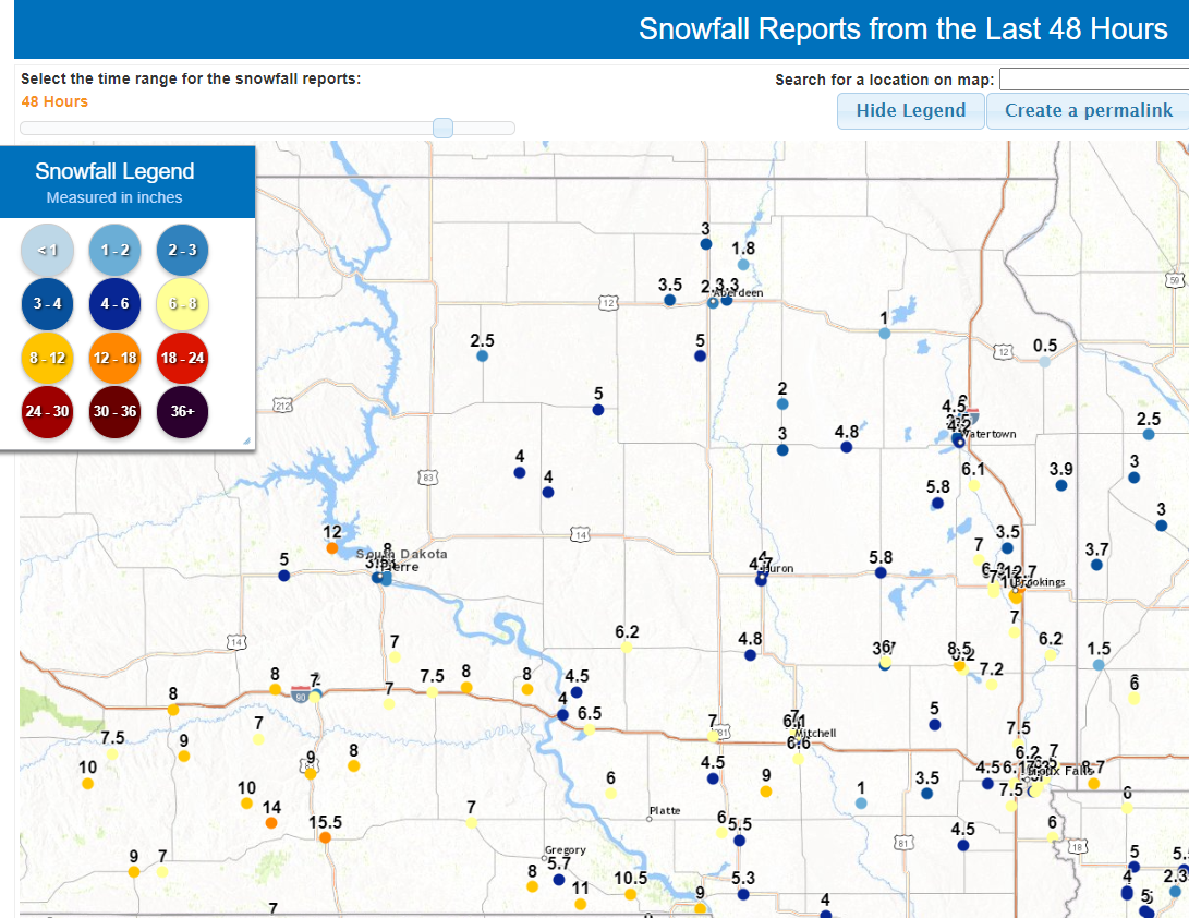
March is one of, if not the snowiest month on average, and this season’s held to character for many as two snowstorms with heavy, wet snow impacted the area. The first, on the 10th, produced a swath of generally 2 to 8” of snow from south central to northeastern South Dakota and west central Minnesota. Aberdeen, Watertown, Pierre and Sisseton all recorded record daily snow, precipitation or both. Resulting treacherous road conditions led to several vehicle accidents. The second, on the 14-15th, impacted south central and east central South Dakota the greatest, where generally 4 to 9” of snow fell (Watertown set a daily snowfall record on the 15th). Persistent breezy to windy conditions combined with the wet snow in near 32 F temperatures to create snow accretion on power lines, which caused a significant strain on wires and poles. As a result, hundreds of people lost power across south central South Dakota, and these outages persisted into the 16th in some cases.
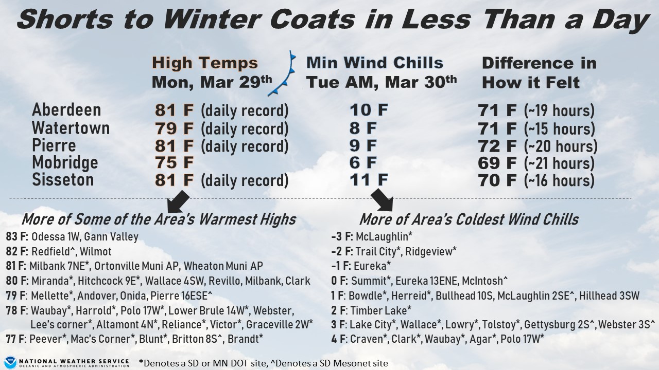
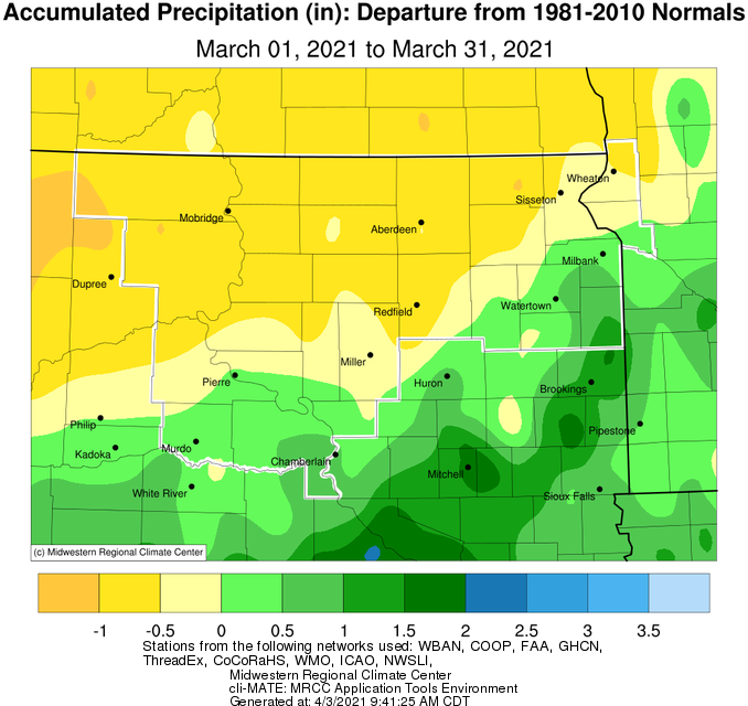
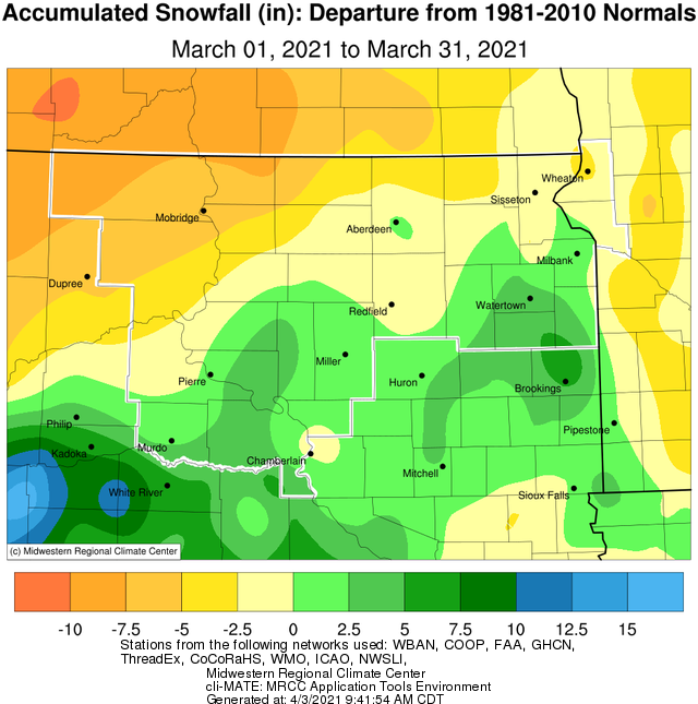
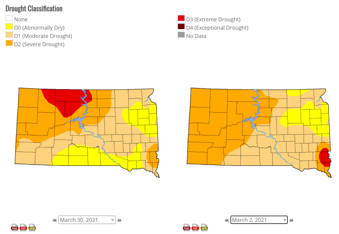
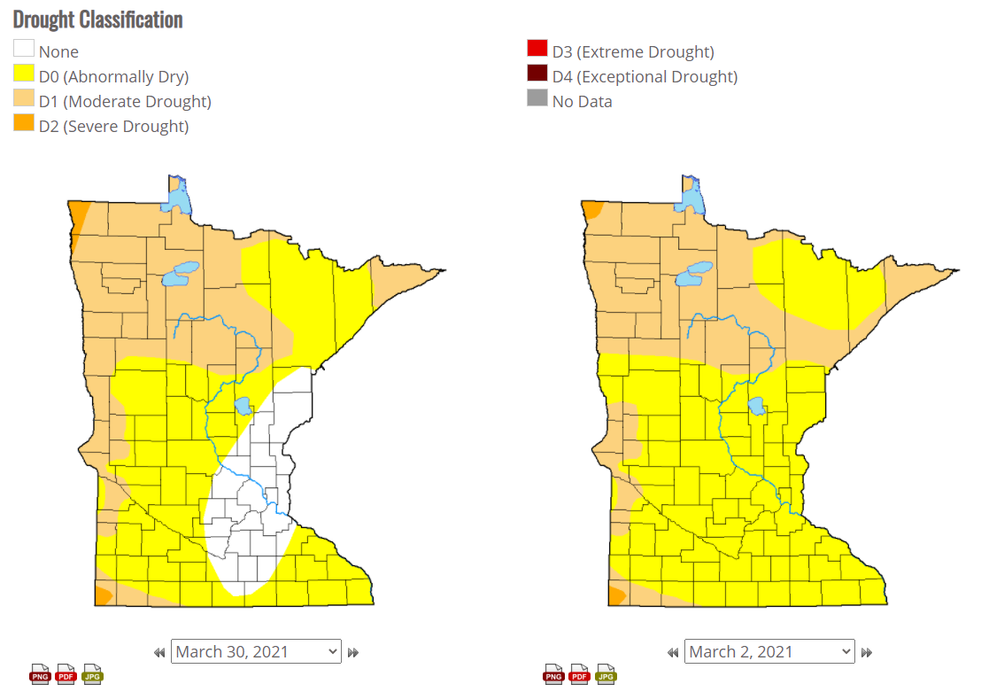
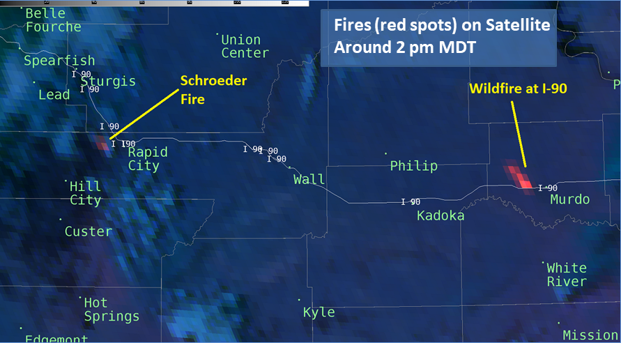
It was a very different story precipitation-wise across north central South Dakota, however. Very little moisture fell, leading to this being the 5th driest March on record in Timber Lake and 4th in Mobridge. While drought conditions remained largely unchanged for most of the area between the beginning and end of the month, north central South Dakota worsened from D2/Severe Drought to D3/Extreme Drought. Areas that did receive accumulating snowfall saw it melt rather quickly given the much above average temperatures, and grasses and other fuels soon dried out. These fuels were dangerously dry everywhere by the end of the month, and fire weather became a large concern particularly on the 29th when a strong low pressure system and cold front passed through the area. High temperatures in the 70s and 80s, relative humidity in the 15 to 25 percent range, and, most significantly, wind gusts of 40 to 60 mph set the stage for large, wind-driven wildfires. Many fires did indeed ignite, the largest of which (in our forecast area) burned around 10,000 acres in central Jones County. Strong winds intensified further overnight with widespread gusts of 50 to 70+ mph, and strong winds persisted through the day on the 30th. A sharp drop in temperatures was also observed. In less than 24 hours, many experienced a drop of about 70 degrees in how it felt, with wind chills in the single digits or teens by the morning of the 30th. Blowing dust was also an issue during this time, leading to very poor visibility at times as well as low air quality. This time lapse video from Mina, SD shows the lofted blowing dust during the afternoon on the 29th: https://video.nest.com/clip/b426f1ab12c54b53828ce36bfd65f36c.mp4.
|
March 2021 |
||||
|
Temperature Data |
Aberdeen |
Sisseton |
Wheaton |
Watertown |
|
Warmest Temperature / Date |
81 /29th |
81 / 29th |
81 / 29th |
79 / 29th |
|
Coldest Temperature / Date |
10 / 1st |
6 / 1st |
1 / 1st |
6 / 1st |
|
Average High / Departure from Normal |
53.5 / +13.5 |
52.5 / +13.2 |
48.9 / +12.1 |
48.0 / +9.1 |
|
Average Low / Departure from Normal |
26.4 / +6.6 |
28.8 / +8.0 |
26.6 / +8.6 |
25.4 / +5.5 |
|
Monthly Average / Departure from Normal |
40.0 / +10.1 |
40.7 / +10.7 |
37.8 / +10.4 |
36.7 / +7.3 |
|
Precipitation Data |
|
|
|
|
|
Monthly Precipitation / Departure from Normal |
0.68 / -0.48 |
0.85 / -0.27 |
1.00 / -0.48 |
1.39 / +0.28 |
|
Most Precipitation in 24 hours / Date |
0.38 / 15th |
0.40 / 10th |
0.47 / 11th |
0.80 / 10th |
|
Monthly Snowfall / Departure from Normal |
8.2 / +1.0 |
4.9 / -3.4 |
4.9 / -3.4 |
10.8 / +4.6 |
|
Most Snow in 24 hours / Date |
4.9 / 10th |
4.7 / 10th |
3.4 / 11th |
6.4 / 10th |
|
Temperature Data |
Pierre |
Kennebec |
Mobridge |
Timber Lake |
|
Warmest Temperature / Date |
81 / 29th |
80 / 29th |
75 / 29th |
71 / 20th |
|
Coldest Temperature / Date |
10 / 1st |
11 / 4th |
10 / 1st |
11 / 31st |
|
Average High / Departure from Normal |
54.2 / +8.8 |
56.1 / +8.2 |
56.2 / +13.6 |
55.2 / +12.0 |
|
Average Low / Departure from Normal |
27.1 / +3.6 |
27.4 / +4.0 |
26.1 / +5.0 |
27.1 / +5.6 |
|
Monthly Average / Departure from Normal |
40.6 / +6.2 |
42.1 / +6.4 |
41.2 / +9.3 |
41.4 / +9.0 |
|
Precipitation Data |
|
|
|
|
|
Monthly Precipitation / Departure from Normal |
1.24 / +0.01 |
1.76 / +0.5 |
0.08 / -0.82 |
0.13 / -1.02 |
|
Most Precipitation in 24 hours / Date |
0.53 / 10th |
0.75 / 15th |
0.04 / 27th |
0.13 / 15th |
|
Monthly Snowfall / Departure from Normal |
7.8 / +1.8 |
11.7 / +3.7 |
0.5 / -5.4 |
1.0 / -6.6 |
|
Most Snow in 24 hours / Date |
6.0 / 10th |
4.5 / 15th |
0.5 / 16th |
1.0 / 15th |
Average temperature departures from normal this March, courtesy of the Midwestern Regional Climate Center.
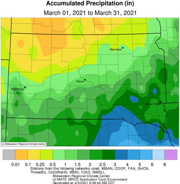
Precipitation totals (left) and departures from normal this March, courtesy of the Midwestern Regional Climate Center.
Snowfall totals (left) and departures from normal this March, courtesy of the Midwestern Regional Climate Center.
Drought conditions at the end (left) and beginning (right) of the month across South Dakota and Minnesota, from https://droughtmonitor.unl.edu/
GOES-16 satellite imagery following the March 10th snowstorm (left) and snowfall reports from the March 14-15th snowstorm (right).
Fire "hot spot" via GOES-16 Satellite shows the location of the large, wind-driven fire across Jones County on the 29th.
Drastic 29th - 30th temperature swing by the numbers.