Widespread life-threatening flash and urban flooding continues in south-central Texas, with considerable flooding impacts possible across central Texas. Wildfire smoke is impacting air quality across much of the Great Lakes region into southern New England and the Mid-Atlantic. Monsoonal thunderstorms may produce isolated to scattered flash flooding across the Southwest into the Great Basin. Read More >
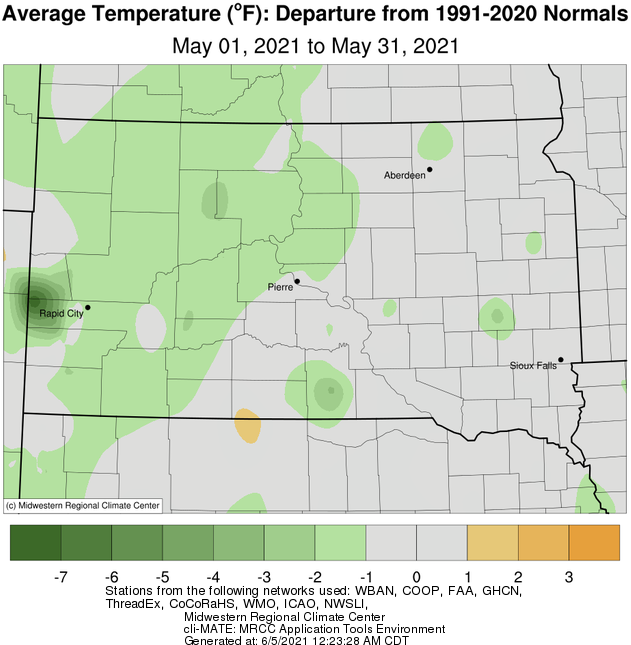
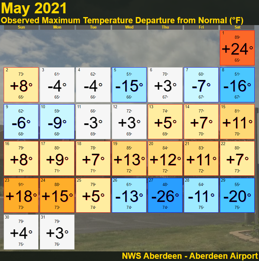
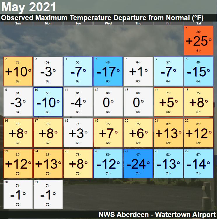
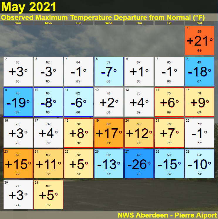
On the whole, temperatures this May were very close to what you’d expect, with only slightly below average. As is typical however, there were some notable swings in temperatures throughout the month. For most locations, the day with the warmest departure from normal took place on the 1st (high temperatures in the mid to upper 80s), and the day with the coldest departure from normal took place on the 27th (record cold highs of 47 F at Mobridge and Pierre). The last freeze (32 degrees or colder) of the season also took place this month, from the 10-12th for most.
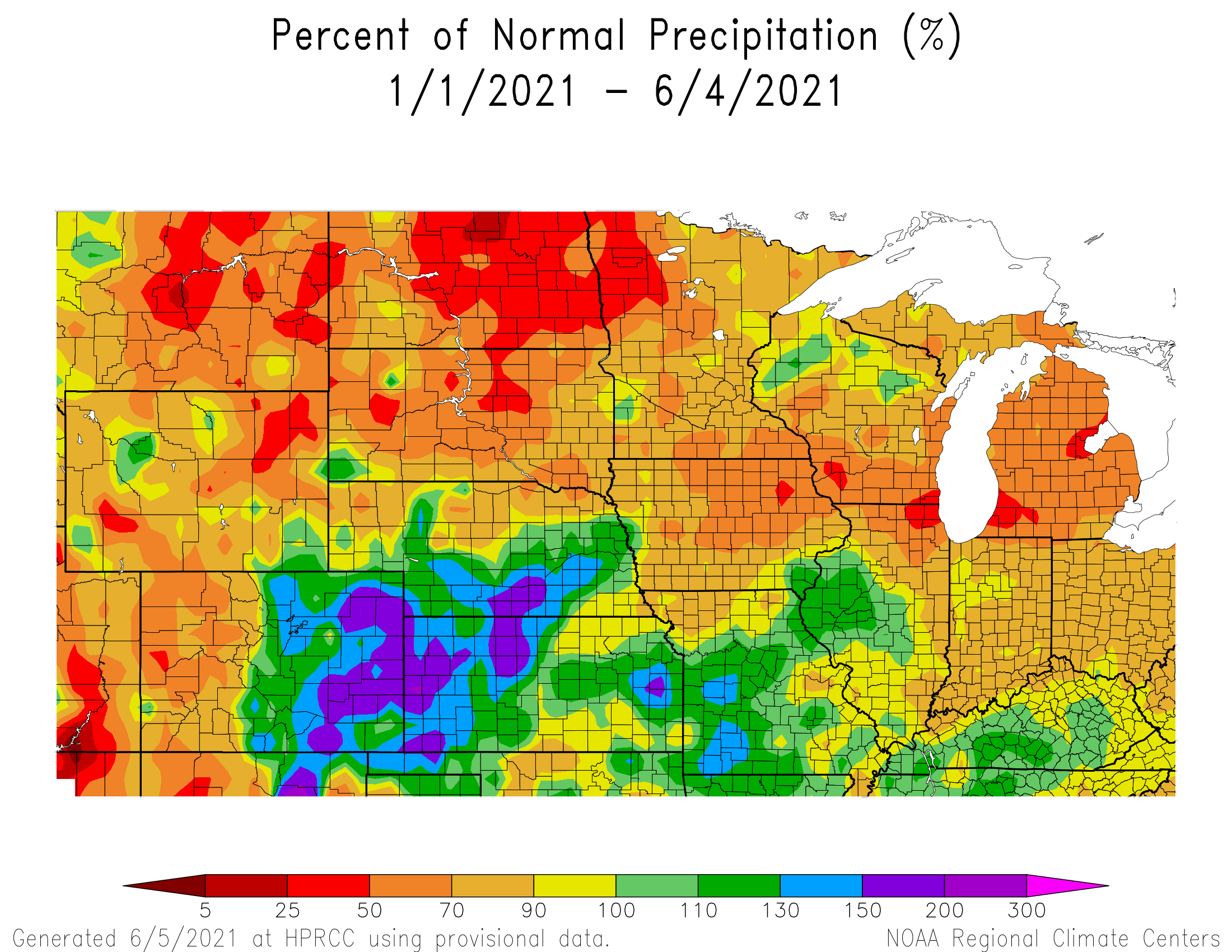
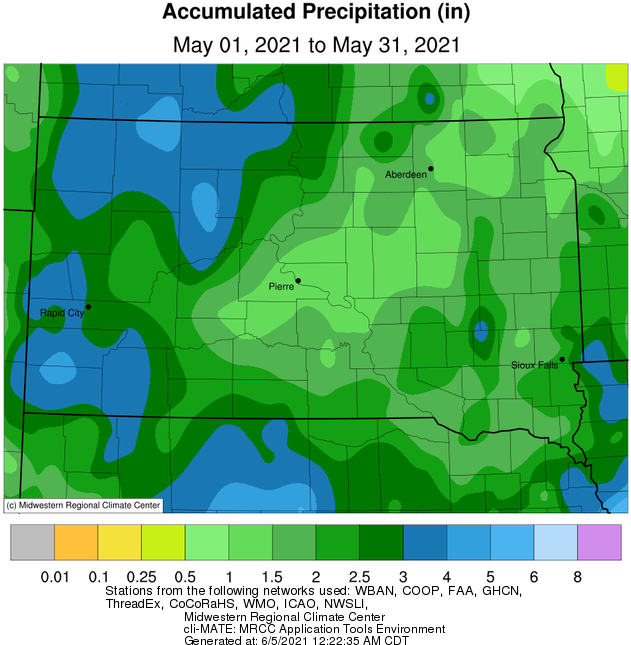
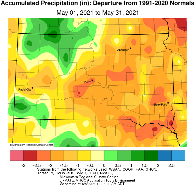
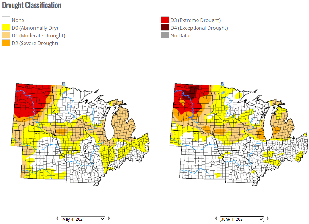
Climatologically, May is the 2nd or 3rd wettest month of the year on average for most locations, so while there were several rounds of precipitation totaling in the 1 to 3” range, everyone except for portions of Dewey and Corson Counties finished below normal this May. Therefore, drought conditions remained largely unchanged from the beginning to the end of the month, including the Extreme Drought across portions of north central South Dakota. Fortunately, some of the heaviest rains of the month fell across portions of north central South Dakota, particularly from the 7th through the 9th (generally 0.5 to 1.5” of rain). Accumulating snow was even recorded on the morning of May 9th, Mother’s Day, west of the Missouri River. Finally, while May can be a volatile month for severe weather, May 2021 was fairly quiet across our forecast area. The main exception was on the evening of the 23rd, when a squall line and outflow boundary tracked from western South Dakota through central and then portions of northeastern South Dakota. Severe wind gusts of 50 to 85 mph were recorded during this time, along with reports of damage.
|
May 2021 |
||||
|
Temperature Data |
Aberdeen |
Sisseton |
Wheaton |
Watertown |
|
Warmest Temperature / Date |
91 / 23rd |
90 / 1st |
89 / 1st |
86 / 1st |
|
Coldest Temperature / Date |
27 / 11th |
29 / 11th |
30 / 4th, 11th |
27 / 4,5,11th |
|
Average High / Departure from Normal |
71.6 / +1.2 |
71.4 / +2.2 |
69.4 / +0.9 |
67.2 / +0.3 |
|
Average Low / Departure from Normal |
43.5 / -0.8 |
44.8 / -0.5 |
45.3 / -1.6 |
43.9 / -0.6 |
|
Monthly Average / Departure from Normal |
57.6 / +0.3 |
58.1 / +0.8 |
57.4 / -0.3 |
55.5 / -0.2 |
|
Precipitation Data |
|
|
|
|
|
Monthly Precipitation / Departure from Normal |
1.61 / -1.67 |
1.32 / -1.47 |
1.52 / -1.28 |
1.84 / -1.03 |
|
Most Precipitation in 24 hours / Date |
0.56 / 8th |
0.83 / 27th |
0.40 / 15,28th |
0.78 / 27th |
|
Monthly Snowfall / Departure from Normal |
0.0 / +0.0 |
0.0 / +0.0 |
0.0 / +0.0 |
0.0 / -0.1 |
|
Most Snow in 24 hours / Date |
N/A |
N/A |
N/A |
N/A |
|
Temperature Data |
Pierre |
Kennebec |
Mobridge |
Timber Lake |
|
Warmest Temperature / Date |
88 / 19th |
87 / 1st |
87 / 1st, 19th |
86 / 19th |
|
Coldest Temperature / Date |
26 / 4th |
25 / 4th |
25 / 4th |
28 / 4th |
|
Average High / Departure from Normal |
69.8 / +0.3 |
72.1 / -0.3 |
70.0 / -0.2 |
68.7 / -0.4 |
|
Average Low / Departure from Normal |
42.8 / -2.1 |
43.3 / -1.6 |
43.4 / -1.6 |
41.8 / -1.6 |
|
Monthly Average / Departure from Normal |
56.3 / -0.9 |
57.9 / -0.7 |
56.7 / -0.9 |
55.5 / -0.7 |
|
Precipitation Data |
|
|
|
|
|
Monthly Precipitation / Departure from Normal |
1.15 / -2.10 |
1.51 / -1.78 |
2.73 / -0.21 |
2.91 / +0.01 |
|
Most Precipitation in 24 hours / Date |
0.51 / 23rd |
0.26 / 8th |
1.22 / 8th |
0.79 / 8th |
|
Monthly Snowfall / Departure from Normal |
0.0 / +0.0 |
0.0 / +0.0 |
0.0 / +0.0 |
0.0 / -0.6 |
|
Most Snow in 24 hours / Date |
N/A |
N/A |
N/A |
N/A |
How much the average temperature of May 2021 varied from normal, courtesy of the Midwestern Regional Climate Center
Calendar day high temperature departures (large number) as well as high temperatures (small top number) and average high temperatures (small bottom number) for Aberdeen, Watertown and Pierre, in that order.
Total precipitation in May 2021, courtesy of the Midwestern Regional Climate Center
How much the total precipitation in May 2021 varied from normal, courtesy of the Midwestern Regional Climate Center
US Drought Monitor on May 4th (left) vs June 1st (right)
Percent of normal precipitation since January 1st, courtesy of the High Plains Regional Climate Center. Areas in the red have seen less than half of what is considered normal for precipitation through June 4th.