
Dangerous heat will expand from the Gulf Coast into the Southern Plains and Desert Southwest through week's end. Additional extreme heat impacting the Pacific Northwest will shift to the northern Plains by the weekend. Tropical Storm Bertha is expected to continue to impact portions of the northwestern Gulf Coast from south central Louisiana to the upper Texas coast today. Read More >
Overview
|
A vigorous late-season storm system raced across northeast South Dakota and west central Minnesota during the early evening on Tuesday, September 19th. Many atmospheric ingredients, including abundant moisture, instability, wind shear and forcing, came together for rapid and intense thunderstorm development. Severe weather in the form of large hail and damaging winds, as well as tornadoes resulted. Locally heavy rain also affected the area, while those west of a line generally from Faulkton to Chamberlain remained dry. |
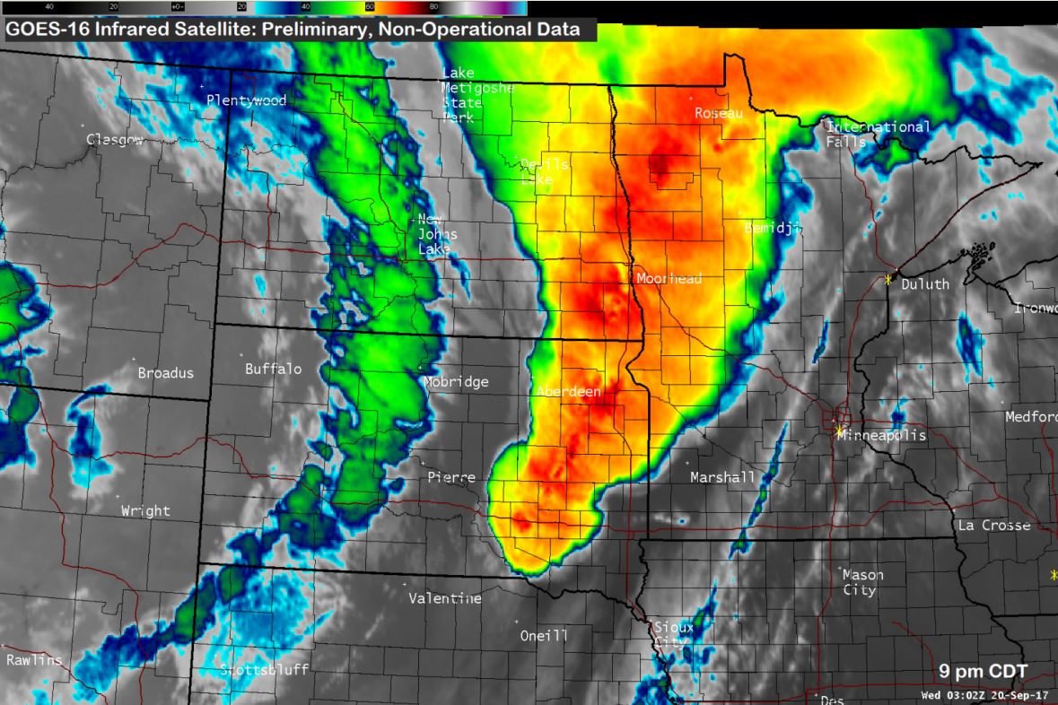 Strong to severe thunderstorms across the region, as seen from GOES-16 at 9 pm |
Tornadoes:
|
Tornado
Track Map  
|
||||||||||||||||
|
Tornado
Track Map 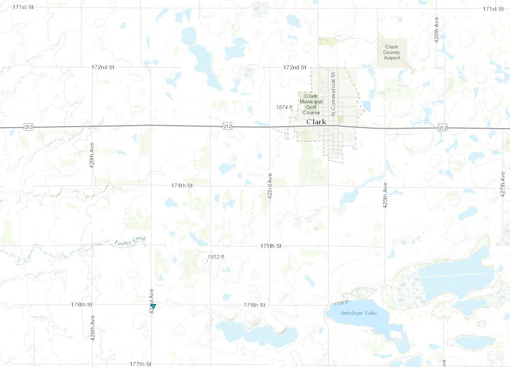
|
||||||||||||||||
|
Tornado
Track Map 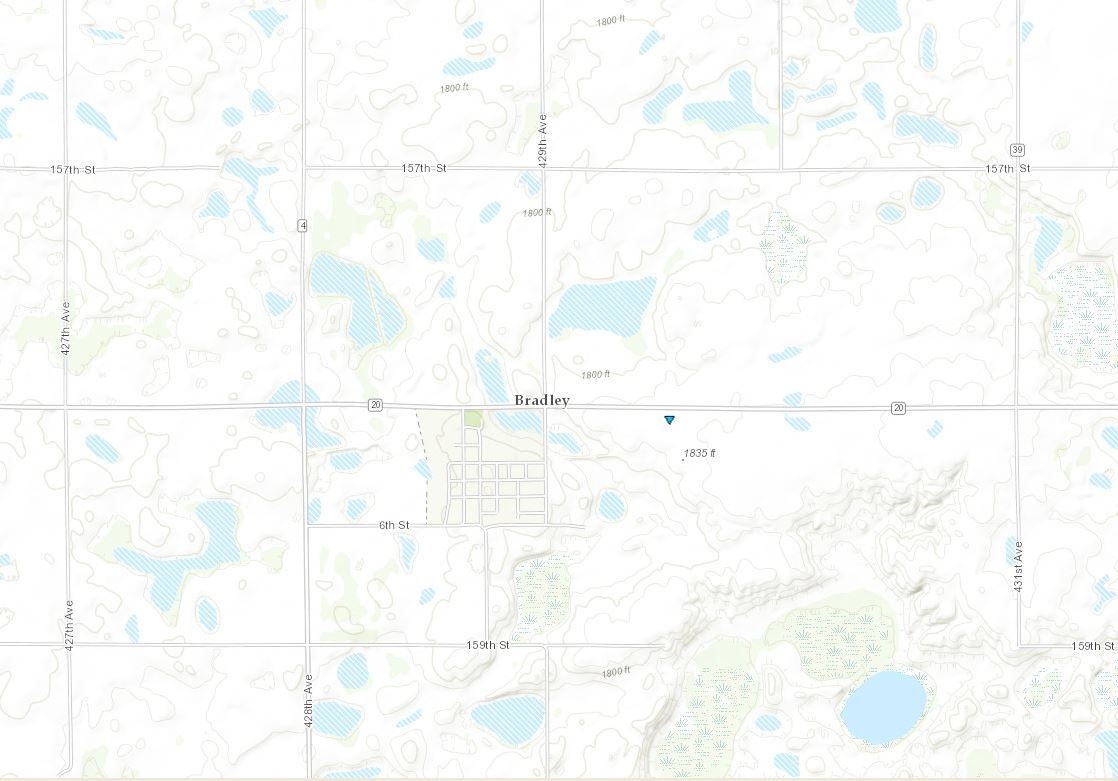
|
||||||||||||||||
The Enhanced Fujita (EF) Scale classifies tornadoes into the following categories:
| EF0 Weak 65-85 mph |
EF1 Moderate 86-110 mph |
EF2 Significant 111-135 mph |
EF3 Severe 136-165 mph |
EF4 Extreme 166-200 mph |
EF5 Catastrophic 200+ mph |
 |
|||||
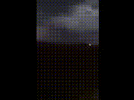
Photos & Video:
.jpg) |
 |
 |
.jpg) |
| Funnel cloud/tornado spotted near Tulare, SD. Credit: Hand County Sheriff | Video taken near Tulare, SD Credit: Hand County Sheriff |
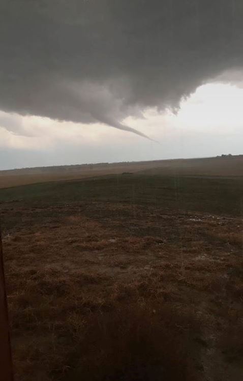
SW of Tulare, SD. Credit: Nick Ihnen | Near Tulare, SD. Credit: Connor Skaare |
.PNG) |
 |
 |
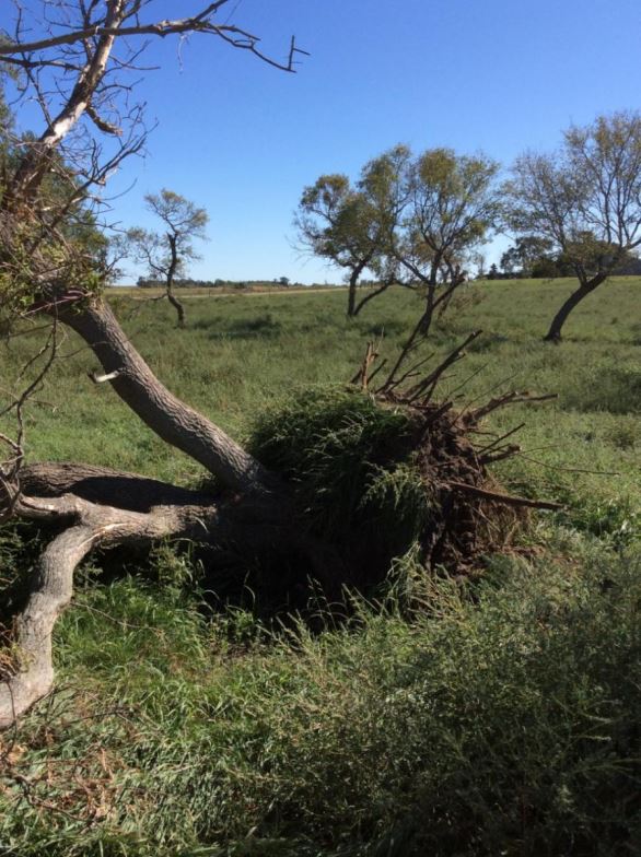 |
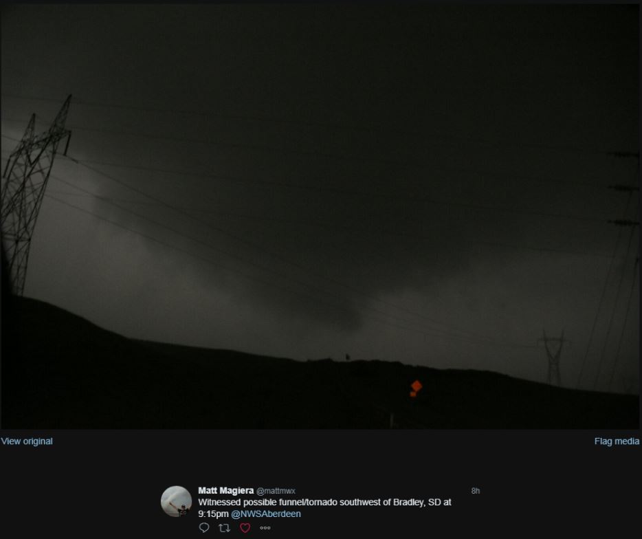
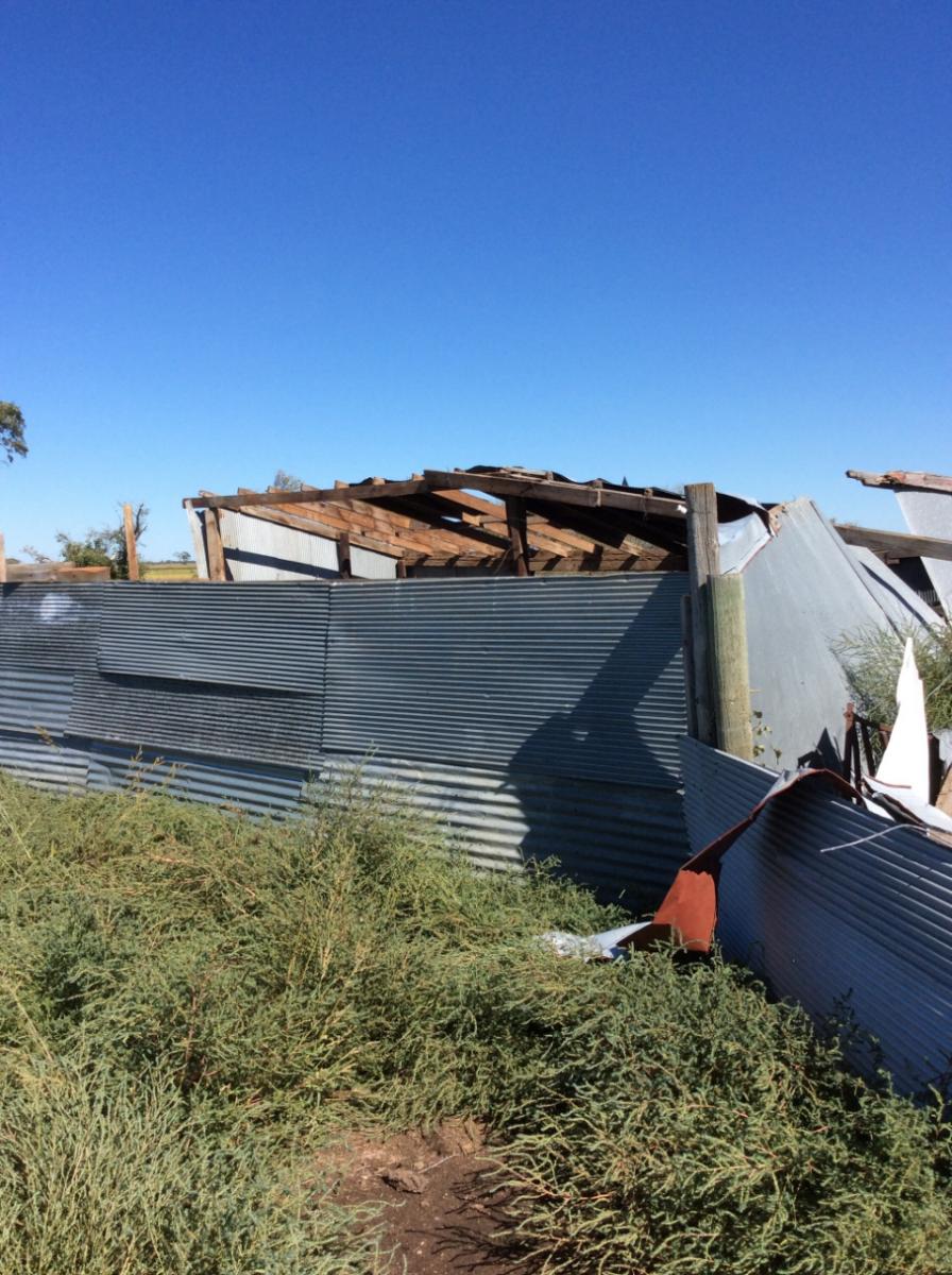
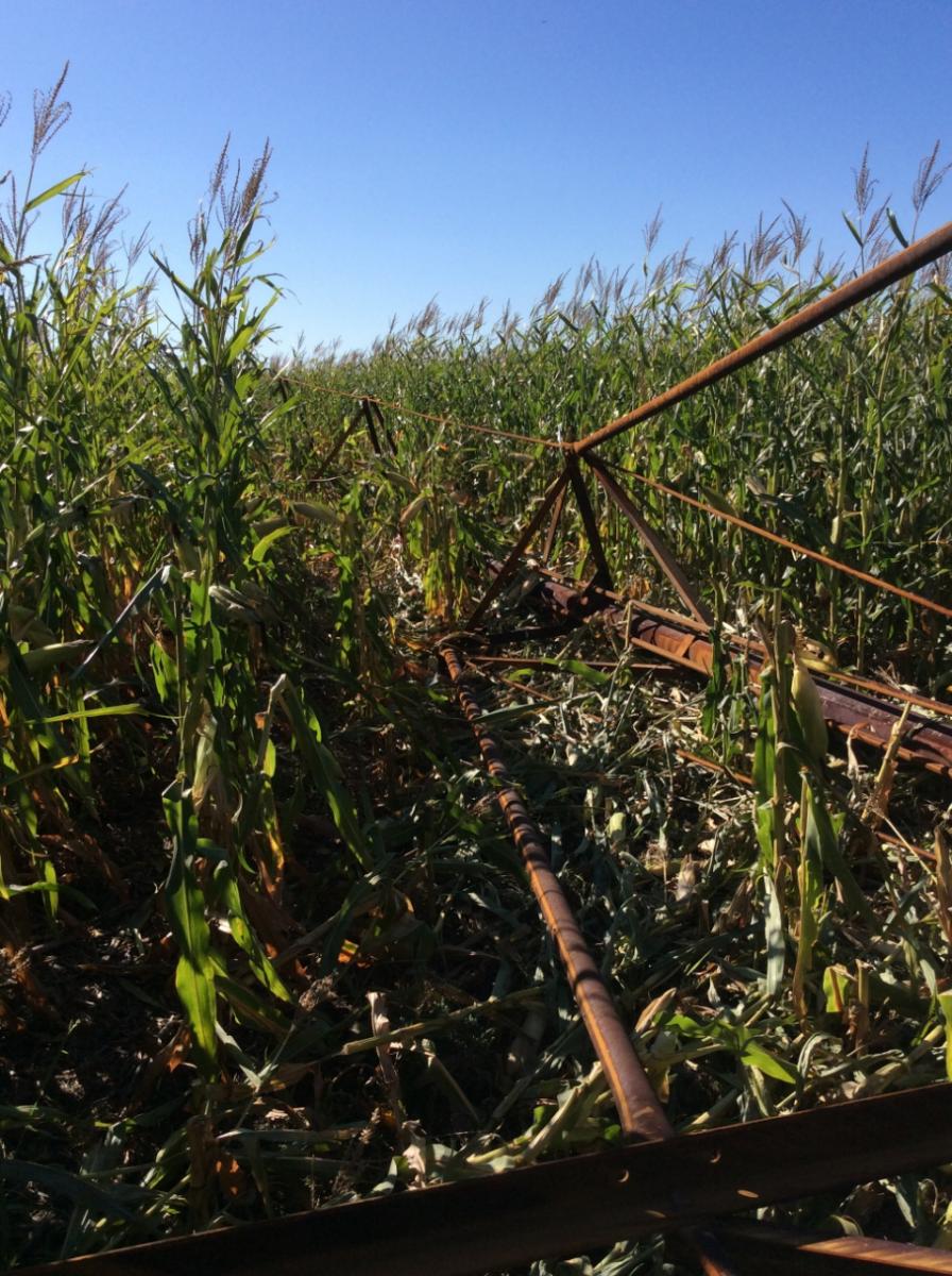
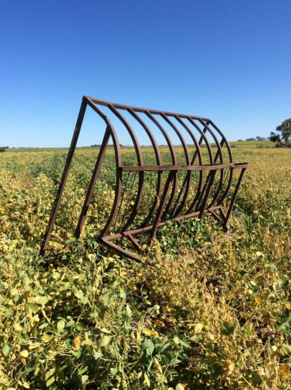
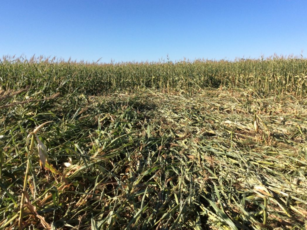
| Funnel Cloud 6 mi S of Redfield at 8:12 PM. Credit: Brandon Whitley via Brent Nathaniel | Possible funnel cloud/tornado captured SW of Bradley, SD. Credit: Matt Magiera | Damage to a farm outbuilding SW of Tulare, SD | Uprooted trees SW of Tulare, SD |
 |
 |
 |
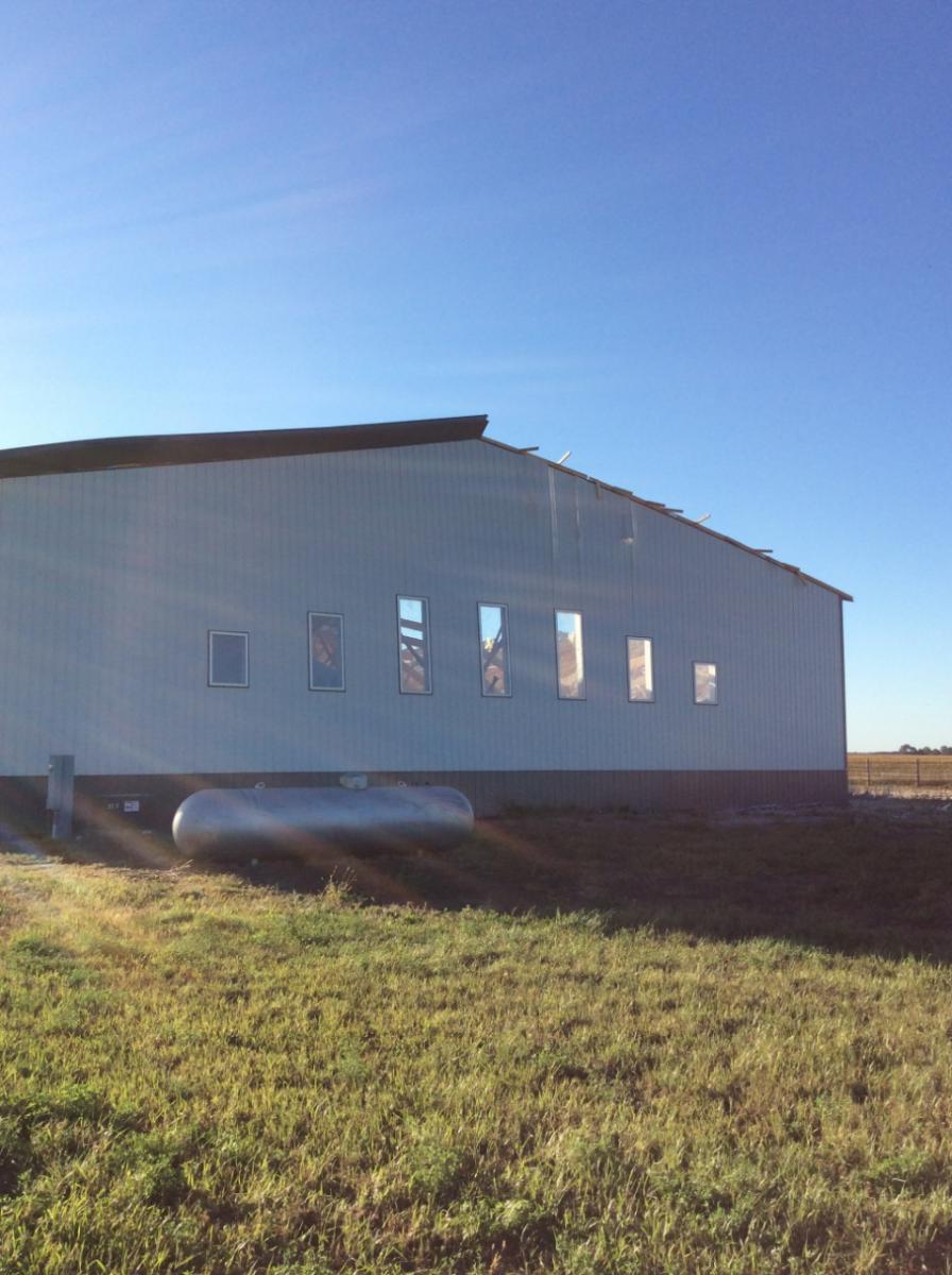 |
| Tipped-over irrigation system SW of Tulare, SD | Feeder thrown into a field SW of Tulare, SD | Converging wind pattern in corn field, created by rotating winds SW of Tulare, SD | Straight-line wind damage to a metal building 6 mi SE of Bath, SD |
Radar:
 |
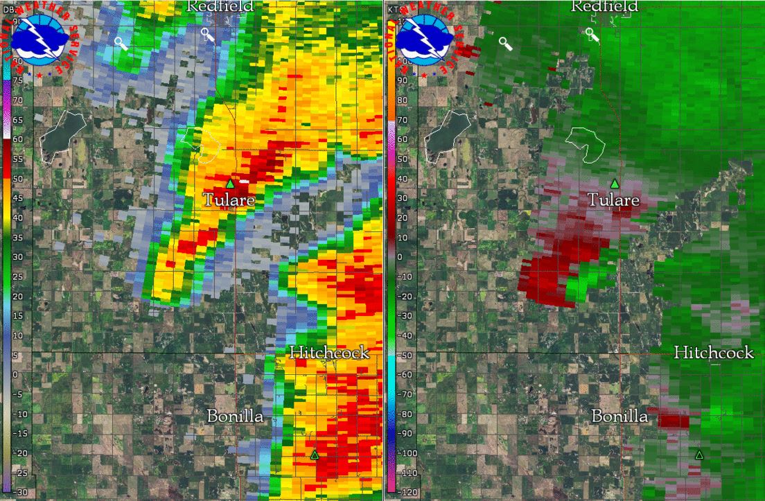 |
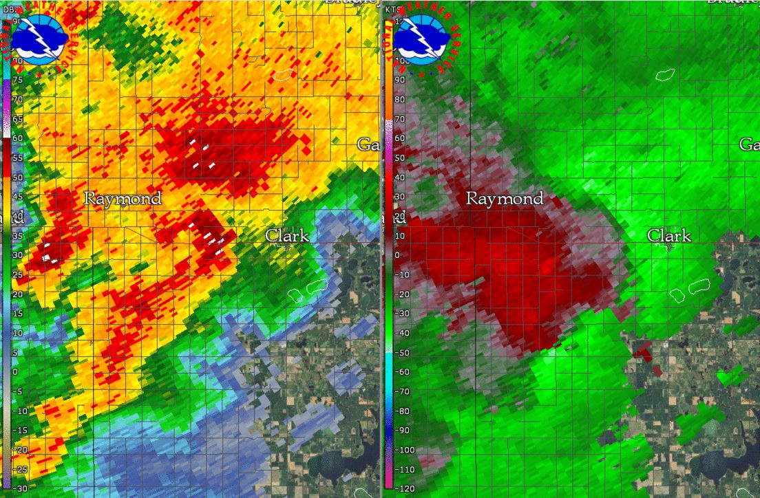 |
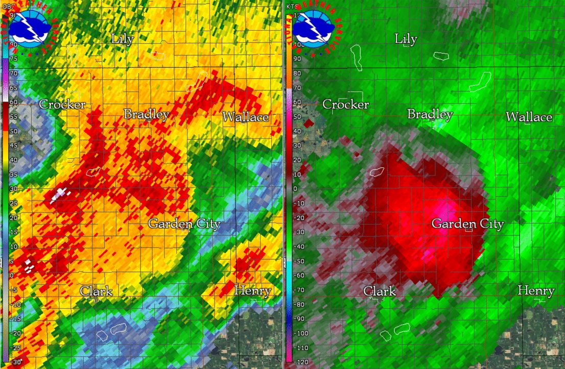 |
| Radar reflectivity overview at 8 pm on September 19th | Radar reflectivity and storm relative velocity of the Tulare, SD storm | Radar reflectivity and storm relative velocity of the Clark, SD storm | Radar reflectivity and storm relative velocity of the Bradley, SD storm |
Storm Reports
Severe weather in the form of large hail and damaging winds also impacted the area. Of note, a supercell storm produced up to golf ball sized hail in and around Java, SD and straight-line winds resulted in the partial loss of a large metal building's roof 6 miles SE of Bath. More reports below. This data is preliminary and subject to change.
.PNG)
..TIME... ...EVENT... ...CITY LOCATION... ...LAT.LON...
..DATE... ....MAG.... ..COUNTY LOCATION..ST.. ...SOURCE....
..REMARKS..
0651 PM HAIL JAVA 45.50N 99.88W
09/19/2017 M1.75 INCH WALWORTH SD PUBLIC
0717 PM HAIL 1 WNW FREDERICK 45.84N 98.53W
09/19/2017 E0.75 INCH BROWN SD PUBLIC
0850 PM HAIL DOLAND 44.89N 98.10W
09/19/2017 E1.00 INCH SPINK SD TRAINED SPOTTER
HEAVY RAINS CAUSING PONDING OF WATER IN CITY
STREETS.
0725 PM HAIL 4 ESE HILLSVIEW 45.65N 99.49W
09/19/2017 E1.50 INCH MCPHERSON SD FIRE DEPT/RESCUE
0715 PM HAIL 7 SW HILLSVIEW 45.58N 99.65W
09/19/2017 E1.50 INCH EDMUNDS SD FIRE DEPT/RESCUE
RADAR ESTIMATED TIME.
0255 PM HAIL 6 NE LONG LAKE 45.92N 99.11W
09/19/2017 E1.00 INCH MCPHERSON SD PUBLIC
0749 PM HAIL 6 WSW HOUGHTON 45.72N 98.31W
09/19/2017 M1.00 INCH BROWN SD EMERGENCY MNGR
0717 PM HAIL 3 NW WESTPORT 45.68N 98.53W
09/19/2017 E1.00 INCH BROWN SD CO-OP OBSERVER
4 INCH DIAMETER APPLES BLOWN OFF TREE. 1.05
INCHES OF RAIN FELL IN 20 MINUTES.
0712 PM HAIL 7 SSW HILLSVIEW 45.58N 99.64W
09/19/2017 M1.75 INCH EDMUNDS SD EMERGENCY MNGR
0700 PM HAIL 1 W RICHMOND LAKE REC A 45.55N 98.64W
09/19/2017 M1.50 INCH BROWN SD PUBLIC
56 MPH WIND GUST ALSO RECORDED.
0808 PM HAIL 5 W HOUGHTON 45.76N 98.31W
09/19/2017 E1.50 INCH BROWN SD EMERGENCY MNGR
0705 PM TSTM WND DMG 9 NNW BOWDLE 45.58N 99.70W
09/19/2017 EDMUNDS SD PUBLIC
HAIL AND WIND DAMAGE INCLUDES BROKEN WINDOWS
AND CORN CROP STRIPPED.
Rain Reports
In addition to severe weather, locally heavy rains accompanied thunderstorm activity. Some street flooding occurred in Watertown, where 1.57" of rain was recorded within an hour's time from 10-11 pm at the airport. Find a radar estimated rainfall map below, and then measured amounts listed further down.

Public Information Statement
National Weather Service Aberdeen SD
1036 AM CDT Wed Sep 20 2017

...24 Hour Rainfall Reports...

Location                     Amount    Time/Date
Clark 7 N                    3.00 in   0900 AM 09/20
Rauville 2 SW                2.75 in   1000 AM 09/20
Hecla 5 NE                   2.73 in   0700 AM 09/20
Sandy Shore State Park 2 NE  2.40 in   1100 PM 09/19
Watertown 2 NNE              2.33 in   0915 AM 09/20
Rauville 2 NNW               2.05 in   0700 AM 09/20
Watertown Muni AP            1.75 in   0653 AM 09/20
Watertown 5 W                1.61 in   0700 AM 09/20
Watertown 2 E                1.56 in   0830 AM 09/20
Watertown 6 ENE              1.53 in   0700 AM 09/20
Watertown 7 SW               1.49 in   0700 AM 09/20
Waverly                      1.48 in   1000 AM 09/20
Watertown 3 SE               1.44 in   1000 AM 09/20
Wallace 5 ENE                1.40 in   1018 AM 09/20
Watertown  2 S               1.27 in   0800 AM 09/20
Wallace 4 SW                 1.22 in   1016 AM 09/20
Rauville 4 SSE               1.13 in   1000 AM 09/20
Garden City 4 S              1.10 in   1000 AM 09/20
Westport 2 NW                1.05 in   0530 AM 09/20
South Shore 8 W              1.04 in   0915 AM 09/20
Clear Lake                   1.03 in   1019 AM 09/20
Hayti                        0.97 in   0800 AM 09/20
Clear Lake                   0.95 in   0624 AM 09/20
Hayti 1 W                    0.91 in   0800 AM 09/20
Columbia                     0.87 in   0800 AM 09/20
Lily 6 ENE                   0.85 in   0700 AM 09/20
Castlewood                   0.84 in   0600 AM 09/20
3 W Stone Bridge             0.82 in   0700 AM 09/20
Strandburg 3 NW              0.77 in   0700 AM 09/20
Hillhead 3 WSW               0.76 in   0959 AM 09/20
Milbank                      0.71 in   0730 AM 09/20
Hecla 7 WNW                  0.70 in   0750 AM 09/20
Ortonville 1n                0.62 in   0800 AM 09/20
Eureka                       0.58 in   0800 AM 09/20
Eureka (COOP)                0.58 in   0800 AM 09/20
Eureka 0.5 S                 0.57 in   1014 AM 09/20
Kidder                       0.57 in   0700 AM 09/20
Odessa 1 W                   0.56 in   0951 AM 09/20
La Bolt                      0.55 in   0616 AM 09/20
Milbank 3 SSW                0.54 in   0800 AM 09/20
Eureka (CWOP)                0.53 in   1010 AM 09/20
Aberdeen 5.5 NNW             0.51 in   0700 AM 09/20
Aberdeen 9 NW                0.49 in   0900 AM 09/20
Groton                       0.48 in   1014 AM 09/20
Webster                      0.40 in   0820 AM 09/20
Veblen 8 W                   0.39 in   0700 AM 09/20
Wheaton 7 ENE                0.39 in   1000 AM 09/20
Aberdeen 9 NW                0.36 in   1016 AM 09/20
Barnard 5 W                  0.36 in   1008 AM 09/20
Aberdeen 7 NNW               0.34 in   0945 AM 09/20
Victor 4 NNE                 0.34 in   0700 AM 09/20
Claremont 2 SSE              0.32 in   0700 AM 09/20
Leola 9 W                    0.28 in   1005 AM 09/20
Turton (CoCoRAHS)            0.24 in   0700 AM 09/20
Turton (UCOOP)               0.24 in   0700 AM 09/20
Grenville 6 ENE              0.24 in   0800 AM 09/20
Dumont 10 NE                 0.23 in   1000 AM 09/20
Aberdeen 6.5 W               0.23 in   1011 AM 09/20
Ashton                       0.21 in   0945 AM 09/20
Wheaton 1 NW                 0.20 in   1000 AM 09/20
Eureka 11 WSW                0.20 in   0700 AM 09/20
Wheaton 1 NNE                0.19 in   0930 AM 09/20
Eureka 13 ENE                0.19 in   1015 AM 09/20
Sisseton 3 W (UCOOP)         0.17 in   0700 AM 09/20
Wheaton 7 WSW                0.17 in   1000 AM 09/20
Sisseton 3 W (CoCoRAHS)      0.17 in   0700 AM 09/20
Leola 9 W                    0.16 in   0700 AM 09/20
Aberdeen 0.5 NW              0.16 in   1019 AM 09/20
Aberdeen 0.5 SE              0.15 in   1018 AM 09/20
Sisseton Muni AP             0.14 in   0656 AM 09/20
Bath 4 WNW                   0.14 in   0700 AM 09/20
Aberdeen 1 SSW               0.13 in   0700 AM 09/20
Eden 7 E                     0.11 in   0800 AM 09/20
Browns Valley 6 N            0.11 in   0700 AM 09/20
Browns Valley                0.10 in   0500 AM 09/20
Britton                      0.10 in   0700 AM 09/20
Bullhead 10 S                0.09 in   1006 AM 09/20
Bath 5 SSW                   0.08 in   0700 AM 09/20
Lake City 4 SE               0.06 in   0700 AM 09/20
Little Eagle 1 SW            0.06 in   0915 AM 09/20
Shambo Ranch 2 NNW           0.04 in   1017 AM 09/20
Mina 7 S                     0.04 in   0900 AM 09/20
Frederick 9 W                0.04 in   0830 AM 09/20
Highmore 12 N                0.03 in   0700 AM 09/20
Browns Valley 3 W            0.03 in   0945 AM 09/20
Aberdeen 5.5 NW              0.03 in   0945 AM 09/20
Lantry 3 NW                  0.03 in   0952 AM 09/20
Hoven 2 N                    0.02 in   0800 AM 09/20
Vivian 7 NW                  0.02 in   1005 AM 09/20
Aberdeen 3 E                 0.02 in   0600 AM 09/20
White Horse 2 ESE            0.02 in   0945 AM 09/20
Aberdeen Rgnl AP             0.02 in   0653 AM 09/20
Mobridge Muni AP             0.02 in   0652 AM 09/20
Leola                        0.01 in   0700 AM 09/20
Graceville 2 W               0.01 in   1000 AM 09/20
Mansfield                    0.01 in   0700 AM 09/20

Observations are collected from a variety of sources with varying
equipment and exposures. We thank all volunteer weather observers
for their dedication. Not all data listed are considered official.
 |
Media use of NWS Web News Stories is encouraged! Please acknowledge the NWS as the source of any news information accessed from this site. |
|

