Weather History - August 24th
Local and Regional Events:
August 24, 1960:
A man was injured when a barn was blown over by an F2 tornado that touched down near Hayes, in Stanley County. Hail, up to golf ball size accompanied the storm as well as about three inches of rain, causing some damage to crops and a farmhouse. The sky color in a westerly direction shortly before the tornado hit was described as a distinct shade of green. Evidence suggests that the tornado may have touched down again in northeast Sully County, destroying a barn, a chicken coop, and haystacks on two farms. Also, precipitation more than 3 inches and locally 6 to 8 inches was accompanied by severe hail, causing damage to buildings and crops. Hail damage was most substantial in Stanly County. The wind carried away an estimated 400 tons of baled hay in Haakon County. A measured rainfall amount of 5.1 inches in less than six hours occurred in Onida, causing extensive flooding of basements, streets, and cropland. Additional rainfall amounts include 5.58 inches 4 NW of Onida, 4.50 inches 23 N of Highmore, 3.05 inches 2N of Onaka, 3.42 inches in Clear Lake, 3.11 inches in Miller, 3.02 inches in Eureka, 2.55 inches 1 NW of Faulkton, 2.40 inches in Gettysburg, 2.22 inches in Blunt, 2.20 inches at Oahe Dam, and 2.16 inches in Clark.
August 24, 1998:
A line of severe thunderstorms raced southeast across Sully, Hyde, and Hand counties during the morning hours, producing destructive winds up to 100 mph and hail up to the size of baseballs. The winds and hail damaged or destroyed a wide swath of sunflowers and corn. Four power poles south of Highmore on Highway 47 were snapped off. The school in Highmore had twenty screens shredded by the hail and the winds. On a farm northeast of Onida, a grain bin was blown over a distance of 200 yards.
August 24, 2006:
Up to 4.25” diameter hail and 9 tornadoes developed across central and northeastern South Dakota between 4:30 pm and 8:00 pm, two of which were rated as F3 intensity. The first of these F3 tornadoes developed in McPherson County west of Hillsview at 5:03 pm, and tracked 24.5 miles
southeast to just north of Hosmer before lifting at 5:30 pm. Numerous livestock and deer were killed. Devastating damage was observed to farm equipment, homes, barns, grain bins, and vehicles. A well-anchored mobile home was completely destroyed. Debris from each site was observed up to 3 miles away. One person received minor scrapes and bruises. The second F3 tornado of the event was spawned by a long-track supercell, and this supercell produced the other 7 tornadoes of the day (two F2, an F1, and four F0 roughly from Onida to De Smet). It touched down just south of Wessington in Beadle County at 6:37 pm, and tracked 19.5 miles southeast to just southwest of Huron before lifting at 7:18 pm. This tornado destroyed 8 houses and numerous farm buildings and damaged at least 7 other houses. Five large high-voltage transmission towers were blown down about 3 miles southeast of Wessington. A woman was cut on the neck at a farm southwest of Wolsey where the house and all other buildings were destroyed (non-life threatening). One other injury occurred southeast of Wolsey.
U.S.A and Global Events for August 24th:
79: Stratovolcano, Mount Vesuvius erupted on this day, burying the Roman cities of Pompeii and Herculaneum. Click HERE for more information from the History Channel.
1456: Machiavelli wrote, "On the 24th of August, about an hour before day-break there arose from the Adriatic near Ancona, a whirlwind, which crossing Italy from east to west, again reached the sea near Pisa, accompanied by thick clouds, and the most intense and impenetrable darkness.” Click HERE to read this book.
1992: Hurricane Andrew made landfall in southern Florida at 4:30 AM on this day. The high winds caused catastrophic damage in Florida, with Miami-Dade County cities of Florida City, Homestead, and Cutler Ridge receiving the brunt of the storm. About 63,000 homes were destroyed, and over 101,000 others were damaged. This storm left roughly 175,000 people homeless. As many as 1.4 million people were left without electricity at the height of the storm. In the Everglades, 70,000 acres (280 km2) of trees were knocked down. Additionally, rainfall in Florida was substantial, peaking at 13.98 in (355 mm) in western Miami-Dade County. About $25 billion in damage and 44 fatalities were reported in Florida. Click HERE for more information from the National Hurricane Center.
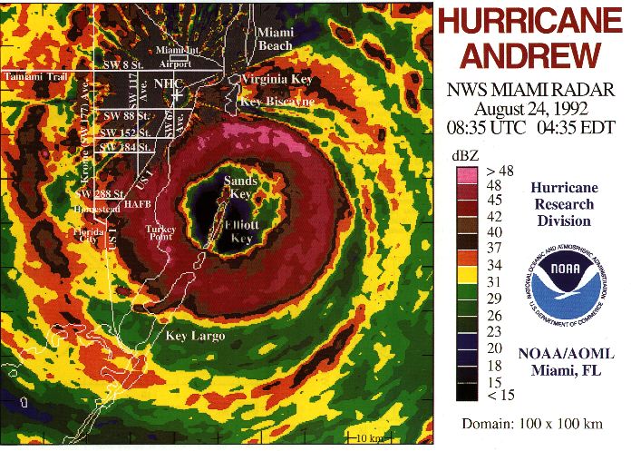
The last radar image was taken from NHC before the WSR-57 radar was blown off the roof, 0835 UTC August 24, 1992.
Click HERE for more This Day in Weather History from the Southeast Regional Climate Center.

