Weather History - December 24th
Local and Regional Events:
December 24, 1985:
Snow fell over western South Dakota on December 23, with the greatest amounts in the northern Black Hills. Strong winds gusting to 50-60 mph developed over the western part of the state on the evening of December 23rd and continued into the morning of the 24th, with gusts to above 40 mph in the east. The winds caused ground blizzard conditions in the northern and central sections of South Dakota, and many vehicles were reported in ditches. Many people were stranded for a time in Martin in Bennett County. Several roads were blocked entirely during this time, such as Highway 248 near Murdo in Jones County.
December 24, 1992:
A deep area of low pressure traveled across the United States/Canada border, dragging a cold front southward across South Dakota and Minnesota by Christmas Day. Southerly winds gusted up to 50 mph over western Minnesota on the 23rd in advance of the storm, causing ground blizzard conditions. As the arctic cold front swept across the area, temperatures tumbled from the 20s and 30s to well below zero by Christmas morning. Wind gusts were up to 50 mph behind the front, causing ground blizzard conditions and wind chill readings from 40 to 60 degrees below zero. A church that was under construction in Litchfield in Meeker County, Minnesota, was destroyed by strong winds. Many motorists were stranded on Christmas Eve and spent the night at area homes and motels. Interstate 94 from Alexandria to Moorhead, MN, was closed for nearly eight hours. High winds gusted up to 55 mph in the Watertown, SD area, causing a steel frame building under construction to collapse sometime between 9 and 10 pm CST.
December 24, 2009:
A broad upper-level low-pressure area over the Upper Midwest associated with an intense surface low-pressure area brought widespread heavy snow along with blizzard conditions to central and northeast South Dakota as well as west-central Minnesota. The storm was a slow mover and produced several rounds of snow over three days. Total snowfall amounts were from 7 to as much as 25 inches. The heavy snow combined with winds of 25 to 40 mph with gusts to 50 mph brought widespread blowing and drifting snow with visibilities frequently less than a quarter of a mile. This blizzard ranked in the top three for South Dakota snowfall with a state average of 15.4 inches. Most of the state received 10 inches of snow or more with many locations with 20 inches or more. Pollock in north-central South Dakota set an all-time high three-day snowfall total with 17 inches. Before the onset of the storm, the Governor declared a state of emergency for South Dakota. Large portions of both Interstates 29 and 90 across South Dakota were closed late on Thursday, December 24th. Both Interstates were closed through Christmas Day and into Saturday, December 26th. There were some stranded holiday travelers due to the road closings, along with a few rescues. Most roads were reopened by Sunday morning, December 27th. There were also several vehicle accidents with nothing serious. Several airports were also closed throughout the storm, along with a few spotty power outages occurring in Lyman County in central South Dakota. Total snowfall amounts over the three days predominantly ranged from 1 to 2 feet. Snowfall amounts with a foot or more included; 12 inches at Mobridge, Eureka, Waubay, and Eagle Butte; 13 inches at Highmore and Miller; 14 inches at
Castlewood, Summit, Watertown, Pierre, and Ree Heights; 15 inches at Groton, Gettysburg, Webster, Wilmot, Hayti, and McLaughlin; 16 inches at McIntosh, east of Hayes and east of Hosmer; 17 inches at Timber Lake, Britton, and Pollock; 18 inches near Victor; 20 inches near Keldron; 22 inches at Murdo; 23 inches at Sisseton and 25 inches at Kennebec. In west-central Minnesota Wheaton received 11 inches, Browns Valley received 15 inches with 16 inches at Ortonville and Artichoke Lake.
U.S.A and Global Events for December 24th:
1851: The Library of Congress caught fire. About 35,000 of the Library’s 55,000 volumes were destroyed. Click HERE for more information from the Library of Congress.

1963: At 0326 CDT on December 24th, 1963, a new all-time low for Memphis occurred with a reading of -13°F. The record still stands today.
1968: The crew of Apollo 8 took this photo, later dubbed “Earthrise,” on December 24th, 1968. During a broadcast that night, pilot Jim Lovell said: “The vast loneliness is awe-inspiring, and it makes you realize just what you have back there on Earth.”

The image above is from a tweet from the NASA History Office.
1971: A commercial airliner encountered severe turbulence from a thunderstorm and broke up in mid-air over Peru. Juliane Koepcke, who was 17 years old, fell roughly 2 miles to earth, still strapped into her seat, survived with a broken collarbone, a gash to her right arm, and her right eye swollen shut. She traveled 11 days through the Peruvian rainforest before being rescued. Click HERE for more information from the BBC.
2004: An extremely rare snowstorm impacts southeastern Texas on this day. Corpus Christi International Airport officially measured 4.4 inches from this event. This was their second white Christmas ever recorded in Corpus Christi. The other white Christmas occurred in 1918 when 0.1 inches was reported. Click HERE for more information from the NWS office in Corpus Christi.
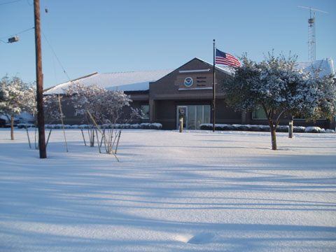
Front Lawn of the NWS Office in Corpus Christi.
Click HERE for more This Day in Weather History from the Southeast Regional Climate Center.

