
A heat wave over the Southwest will intensify this week, peaking and expanding into the Intermountain West and northern High Plains this weekend. Critical to extremely critical fire weather conditions are forecast from the Northwest and the northern Great Basin this weekend. Particularly Dangerous Situation Red Flag Warnings have been issued. Read More >
Weather History - January 18th
Local and Regional Events:
January 18, 1979:
An area of low pressure moving across the region brought widespread snow of 5 to 10 inches to much of Minnesota from the 18th through the 20th. Travel was difficult, if not impossible, in many areas where there were near blizzard conditions. Schools and businesses closed, along with many flights canceled.
January 18, 1999:
One to 4 inches of snowfall combined with winds of 30 to 45 miles an hour brought blizzard conditions to part of northeast South Dakota. Highway 12 and Interstate 29 were most affected by the low visibilities. There was a seven-car pileup on Highway 12 near Andover with minor injuries. As a result, traffic was shut off in the westbound lanes for a few hours. Over 200 people were stranded overnight at a restaurant near Summit. There was also a rollover north of Summit, which resulted in minor injuries. One traveler said the visibility was frequently near zero.
January 18, 2014:
A strong Alberta Clipper low-pressure system moved over the Northern Plains Friday night and Saturday morning. Anywhere from a trace to just near 3 inches of fresh snowfall accompanied this low-pressure system. Over this area, strong northwest winds of 25 to 40 mph developed by late Friday night with gusts of 45 to 55 mph. A few areas even experienced gusts to 58 mph or higher again. This system packed such a wallop that a couple of instances of thundersnow occurred, as evidenced by the cloud to ground lightning strikes showing up in southwestern Day County and northwestern Clark County early Saturday morning.
Numerous reports of visibility reduced to one-quarter mile or less across northeast South Dakota, specifically on or just to the east of the Glacial Lakes region, were received. Click HERE for more information.
U.S.A and Global Events for January 18th:
1943: Idaho's coldest night on record occurred as the low temperature dropped to 60 degrees below zero at Island Park Dam.

1950: Oregon continued in the grips of one of its worst winter months ever. A significant winter storm brought a thick glaze of ice to Columbia River Gorge, stopping automobile traffic in its tracks. Hundreds of motorists were stranded and had to be rescued by train. Even that wasn't easy with the coating of ice. The storm caused widespread power outages. Click HERE for more information.

1971: A warm Santa Ana condition brought a 95 degree reading to Los Angeles, the highest January temperature on record. It was 95 degrees in Palm Springs, the highest temperature on record for January as well.

The image above is from the January 1971 Climatological Data for California.
1973: The first tornado death of the year has been registered north of Corey, Louisiana, during the afternoon hours. Although a girl was killed when a tenant farm was destroyed, a baby received only minor injuries when it was carried 300 to 400 yards by the tornado. Click HERE for more information from TornadoTalk.com

The image above is from Storm Data.
1978: In Connecticut, the Hartford Arena collapsed after experiencing the largest snowstorm of its 5-year life. Multiple issues caused the collapse. Click HERE for more information from ConnecticutHistory.org

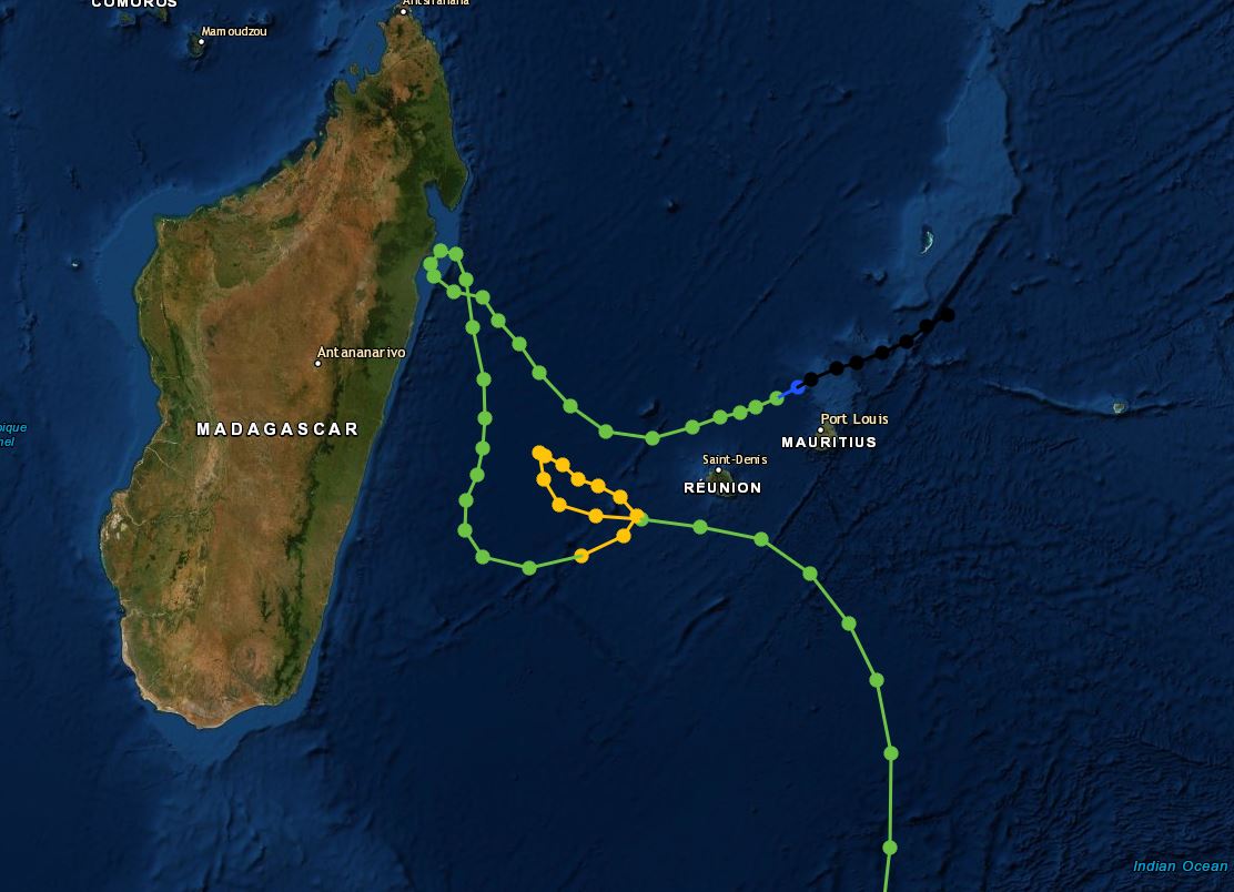
1980: A tropical depression that developed on January 15th became Tropical Storm Hyacinthe on the 18th. From the 18th through the 27th, this storm produced a world-record rainfall amount of 223.5 inches at Cratère Commerson on La Réunion. Click HERE for more information from the Hurricane Research Division.

The hurricane track below is from NOAA.
Click HERE for more This Day in Weather History from the Southeast Regional Climate Center.

