
Widespread life-threatening flash and urban flooding continues in south-central Texas, with considerable flooding impacts possible across central Texas. Wildfire smoke is impacting air quality across much of the Great Lakes region into southern New England and the Mid-Atlantic. Monsoonal thunderstorms may produce isolated to scattered flash flooding across the Southwest into the Great Basin. Read More >
Weather History - January 22nd
Local and Regional Events:
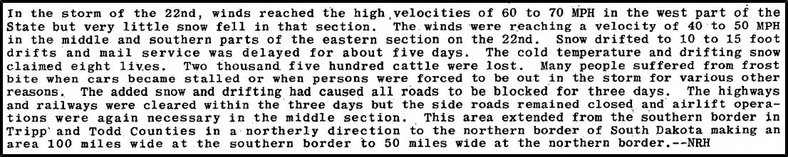
January 21-22, 1952:
A significant winter storm impacted South Dakota, bringing snow, bitter cold temperatures, snow with snowdrifts of 10 to 15 feet. The cold temperatures and drifting snow claimed eight lives. At least 2,500 cattle were lost. Many roads were blocked for three to five days.
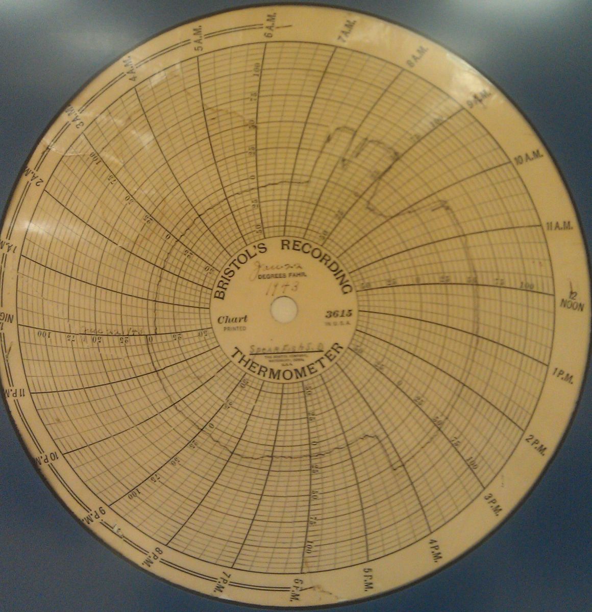
January 22, 1973:
During the early morning hours, Chinook winds caused the temperature at Spearfish, South Dakota, to rise from 4 below zero to 45 above in just two minutes, the most dramatic temperature rise in the world. An hour and a half later, the mercury plunged from 54 above to 4 below zero in 27 minutes. Click HERE for more information from the National Weather Service office in Rapid City.
January 22, 1982:
A winter storm lasting three days from the 22nd to the 24th virtually paralyzed South Dakota with snowfall of 6 to 20 inches. Subzero temperatures statewide coupled with strong winds of 30 to 50 mph brought wind chills of 50 to 70 below zero. One woman died of exposure near her home in Aurora County. Snow drifted as high as 15 feet. Blowing snow caused a reduction in visibility to near zero for most of the duration of the storm. Hundreds of motorists were stranded. Numerous traffic accidents occurred due to near zero visibilities. Some power outages occurred. Major highways, interstates, and airports were closed. Multiple businesses and schools were closed for several days.
January 22, 2010:
A powerful mid-season winter storm moved northeast out of the four corners region of the United States and into the Northern Plains. Ahead of this system, warm and moist air streamed northward, creating widespread fog and freezing fog conditions during the days leading up to the event. Heavy riming frost began to accumulate on power lines and tower guide wires, placing a heavy strain on them when the freezing rain arrived in the late morning and afternoon hours on Friday, January 22nd. Along with the freezing rain, southeast winds gusting to 30 mph also strain sagging power lines. Scattered power outages were reported as early as Tuesday, January 19th, due to the frost-covered lines. Still, most of the power lines and power pole damage occurred during the evening of the 22nd and the morning of the 23rd. The freezing rain that arrived during the afternoon and evening of the 22nd was the proverbial "straw that broke the camel's back." By the time the rain, freezing rain, and snow ended Saturday morning, January 23rd, nearly every power cooperative across central and northeast South Dakota suffered large power pole and power line damage. Also, several radio and television towers were downed by the icing and strong winds. The heavy icing and strong winds downed over 5000 power poles and 21,000 miles of power lines across South Dakota, leaving thousands of households without power. Several homes sustained substantial damage caused by broken water pipes. Power was still not restored for many customers until several weeks after the event. Power line crews from Minnesota, Kansas, and Oklahoma were called upon to help restore power. Several counties, along with the state emergency operations center, opened emergency shelters for people to stay. Forty-one National Guard members were on active duty across the state, helping to restore power. Many flights were delayed or canceled at several airports. The ice and the wind also helped topple a canopy at a truck stop at Highway 20 and 212. On January 23rd, a radio and television transmission tower northwest of South Shore was downed along with a tower north of Reliance and a radio tower southwest of Marvin. The hardest-hit area with this storm was the Cheyenne River and Standing Rock Sioux reservations in central and north-central South Dakota. With no electricity, residents depended on donations of food, bottled water, blankets, heat and light sources, toiletries, and cots. The rural water system serving the Cheyenne River Sioux Tribe was shut down, resulting in the state EOC shipping water to the reservation. The Governor asked for a presidential disaster declaration for most of the counties and three reservations. The request was for both public and individual assistance for total damages estimated over 20 million dollars for the state.
U.S.A and Global Events for January 22nd:
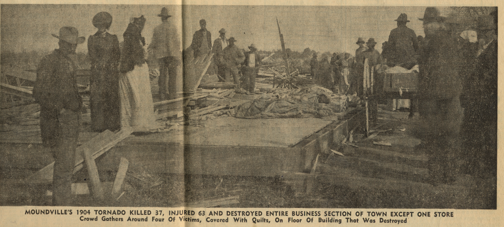
1904: An unusual estimated F4 tornado leveled the northern part of Moundville, Alabama, just after midnight, killing 37 people. The tornado reportedly had a phosphorescent glow. An engineer on a northbound Great Southern train saw the destruction right after it occurred and backed his train 12 miles in reverse to the town of Akron, where he sent a telegram for help. Click HERE for more information from the NWS Office in Birmingham, Alabama.
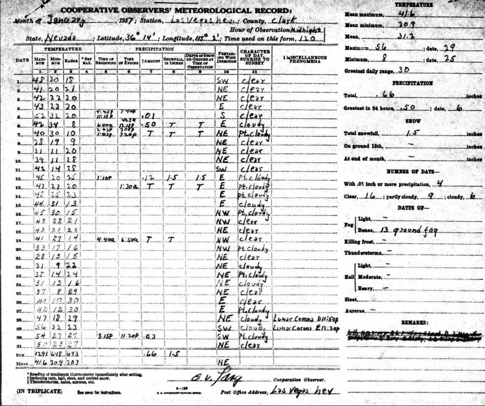
1937: Low of 9 degrees above zero in Las Vegas froze many pipes. Schools had trouble keeping warm, and coal was in short supply in the city. January 1937 was the coldest month on record for Las Vegas, with an average temperature of 31.2 degrees, 17.5 degrees below normal.
Click HERE for more This Day in Weather History from the Southeast Regional Climate Center.

