Weather History - November 19th
Local and Regional Events:
November 19, 1981:
A storm system moved from southeast Nebraska through Iowa on the 18th and spread rain and sleet as well as a few thunderstorms into southern Minnesota. Rain and sleet began changing over to snow during the afternoon on the 18th and continued through the 19th. The most substantial snowfall was in the Minneapolis area. The 10.4 inches of snow reported from the National Weather Service office in the Twin Cities was the heaviest snowfall recorded at the office since March 22nd, to the 23rd, 1965 when 13.6 inches fell. The storm knocked out power and phones to many in the Twin Cities metropolitan area. Damage was also done to the Humber H. Humphrey Metrodome, where the weight of the heavy snow caused the newly inflated, fabric dome collapsed and ripped.
November 19, 1996:
Widespread freezing rain spread a layer of ice across a large area before changing over to snow during November 19-20. Snowfall amounts were 1 to 3 inches in central South Dakota, 3 to 7 inches across north central South Dakota, 5 to 6 inches in west central Minnesota, and 4 to 12 inches across northeast South Dakota. Travel was difficult, and several schools were closed or delayed. Mail delivery was also slowed or postponed for a day or two. Several, mainly minor accidents, resulting in several minor injuries, occurred as a result of the ice and snow covered roads. Two Milbank buses slid into ditches. Strong north winds led to near-blizzard conditions across northeast South Dakota on the 20th. Some snowfall totals included; 12.0 inches in Clear Lake and near Milbank; 10.1 inches near Mellette; 9.0 inches in Browns Valley; 8.3 inches near Big Stone City; 8.0 inches in Faulkton; and 7.0 inches in Britton and Conde.
U.S.A and Global Events for November 19th:
1921: The Columbia Gorge ice storm finally came to an end. In Oregon, 54 inches of snow, sleet, and glaze blocked the Columbia River Highway at The Dalles. Apart from traffic on the river itself, all transportation between Walla Walla WA and Portland, OR came to a halt. Nine trains were stopped as railroads were blocked for several days.
1930: A rare, estimated F4 tornado struck the town of Bethany, Oklahoma. Between 9:30 am and 9:58 am CST, it moved north-northeast from 3 miles west of the Oklahoma City limits, and hit the eastern part of Bethany. About 110 homes and 700 other buildings, or about a fourth of the town, were damaged or destroyed. Near the end of the damage path, 3.5 miles northeast of Wiley Post Airfield, the tornado hit the Camel Creek School. Buildings blew apart just as the students were falling to the floor and looking for shelter, and five students and a teacher were killed. A total of 23 people were killed and another 150 injured, with 77 being seriously injured. Damage estimates were listed at $500,000. Click HERE for more pictures from KOCO.com
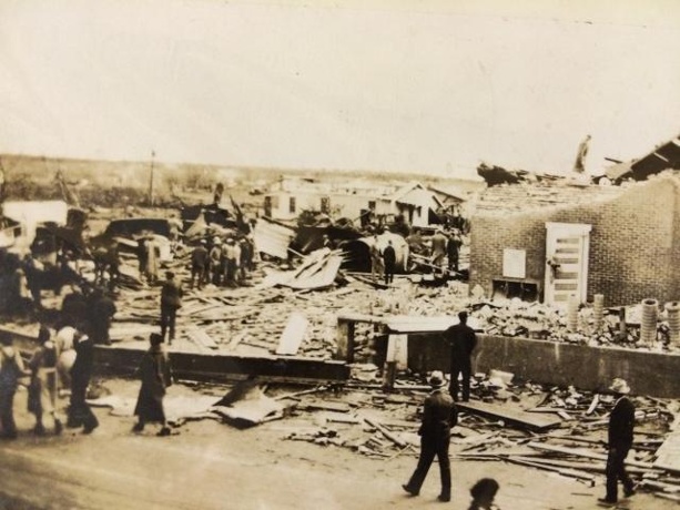
Above is tornado damage in Bethany, Oklahoma. The image is courtesy of KOCO in Oklahoma City.
Click HERE for more This Day in Weather History from the Southeast Regional Climate Center.

