
Tropical system in the Gulf expected to gradually strengthen the next couple of days off the Florida Panhandle and Alabama coasts. Instances of flash flooding will be possible through Thursday along the eastern and central Gulf Coast. Severe thunderstorms will develop and move along a cold front crossing the Upper Midwest, and through the Ohio Valley/Mid-Atlantic on Tuesday. Read More >
Weather History - October 5th
Local and Regional Events:
October 5, 1982:
Strong thunderstorms developed across central South Dakota and raced into portions of southwest Minnesota. The storms were prolific lightning producers in South Dakota, setting several structures on fire. An electrical substation was damaged near Salem, an elementary school was set ablaze in Aberdeen, and several homes in Sioux Falls were struck. One house in Sioux Falls had a hole knocked in a wall by a lightning strike.
Numerous fires were also started in southern Minnesota by the same line of storms. Strong thunderstorm winds leveled several buildings, damaged a house, and moved a hog shed off its foundation on three separate farms near Worthington. The winds also turned over railroad cars near Pipestone. Worthington narrowly escaped damage as a small tornado touched down two miles southwest of town and moved southeast. Fortunately, the tornado's damage was confined to trees and crops.
October 5, 2013:
A historic blizzard pounded western South Dakota with record-setting snowfall and high winds for almost 48 hours from October 3 through the afternoon of October 5. One to two feet of snow was reported over the plains of western South Dakota, with three to five feet of snow falling over the northern and central Black Hills. Wind gusts to 70 mph across the plains produced significant blowing and drifting snow, with visibilities near zero for much of the day on October 4. The heavy wet snow and strong winds downed trees and power lines, causing prolonged outages and impassable highways. The roofs of several businesses, a middle school, and a community center collapsed from the heavy snow. Thousands of livestock were killed from hypothermia, suffocation, or drowning. The South Dakota Animal Industry Board received over 21,000 cattle; over 1300 sheep; 400 horses; and 40 bison deaths from the storm. Tree and debris removal costs were several million dollars. An unyielding low-pressure area moving across the region brought an early fall blizzard to most of the counties west of Missouri River on October 4th and 5th. The snowfall and blizzard conditions occurred mainly along with the western parts of the counties. The snowfall amounts varied broadly from 1 to 2 inches to as much as 22 inches in far western Corson County. Very strong northwest winds of 30 to 50 mph with gusts to 60 mph brought blizzard conditions and significant travel problems. Interstate-90 was closed from Murdo to the Wyoming border from 7 pm on October 4th to October 8th. No travel was advised on all roads west of the Missouri River. Many cattle were also lost in western Corson County due to the storm. The heavy snow, along with strong winds, resulted in some power outages and some downed tree branches. The snowfall began in the late morning hours of the 4th and ended in the early afternoon hours of the 5th. Some snowfall amounts that occurred were 1 inch at Murdo; 2 inches at Timber Lake and 5 miles west of Hayes; 4 inches at McIntosh; 16 inches southeast of Morristown; and 22 inches southwest of Keldron.

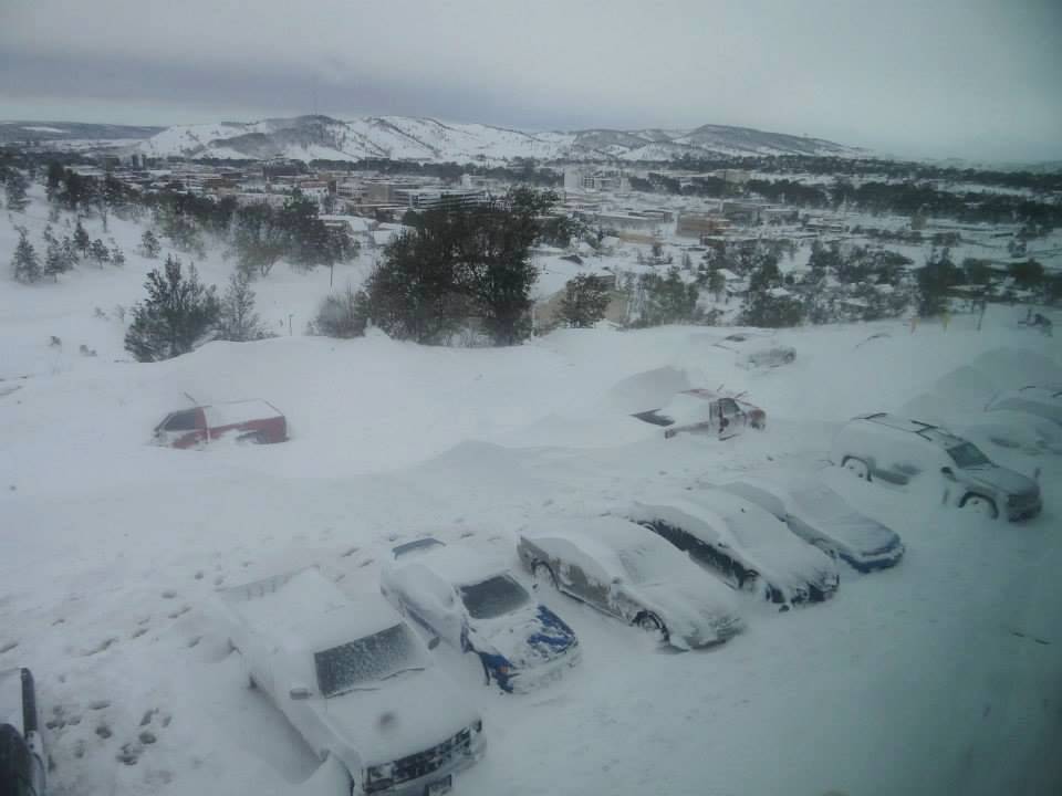
The photo above of Rapid City, South Dakota is courtesy of Ryan Lueck.
Click HERE for more information from the NWS Office in Rapid, City, South Dakota.
U.S.A and Global Events for October 5th:
1786: The famous “Pumpkin Flood” occurred on the Delaware and Susquehanna Rivers. Harrisburg, PA, reported a river stage of twenty-two feet. Click HERE for a youtube video.
1864: A tropical cyclone hit India near Calcutta, devastating the city and killing about 60,000 people. Click HERE to read the Report on the Calcutta Cyclone of 5th October 1864.

"Effects of the cyclone at Calcutta," from the Illustrated London News, 1864.
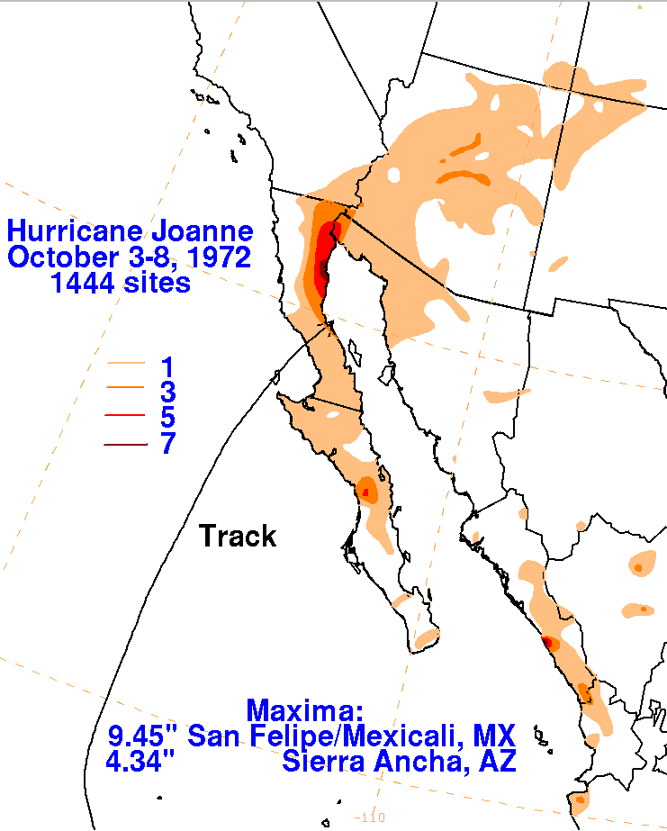
1972: Tropical Storm Joanne, earlier a hurricane, moved across the Baja California peninsula and came ashore in western Mexico south of Ajo. The storm brought heavy rain and flooding to much of Arizona. This storm is the first documented tropical storm to reach Arizona, with its cyclonic circulation intact. Over 5 inches of rain was reported on the Mogollon rim southeast of Flagstaff. Additional rainfall amounts included 4.44 at Flagstaff, 3.80 at Prescott, 2.21 at Yuma, 1.95 at Phoenix, 1.63 at Nogales, and 1.63 at Tucson.

The image above is from the ESSA 9 weather satellite of Hurricane Joanne taken on October 2, 1972, at 2233 UTC.
Click HERE for more information from the Weather Prediction Center.
2010: Large hail pounded Phoenix, Arizona, causing nearly $3 billion in damage. Click HERE for more information from the NWS Office in Phoenix, Arizona. Click HERE for a YouTube video.
Click HERE for more This Day in Weather History from the Southeast Regional Climate Center.

