TOP 5 WEATHER EVENTS
While many significant weather events affected many people across central and northeast South Dakota and west central Minnesota in 2015, below is a listing of the top 5 events of the year in terms of scope, severity of impacts, and/or rarity. In chronological order:
Dry January-April, Then Drought-Busting May
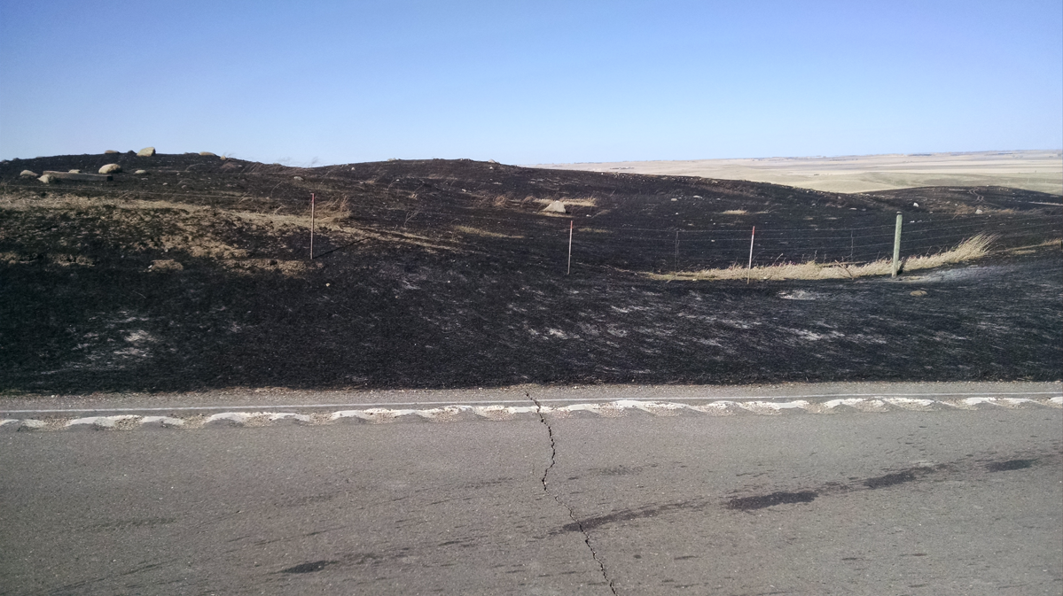
From January 1st through April 30th, many locations had one of their top ten driest periods since records began. This period was the driest on record for Kennebec, Murdo, and Pierre with around only one inch of total precipitation. Gettysburg, Summit, Selby, and Mellette all had their second driest January through April period with Sisseton having the third driest, Watertown fourth driest, and the sixth driest at Aberdeen. This, coupled with much above normal temperatures, led to a fairly active fire season particularly in March and April as fuels became quite susceptible. One such fire occurred during the first half of April west of Glenham (photo below).
By the start of May, much of South Dakota was in moderate (D1) or severe (D2) drought. However, by the end of May, the majority of the state was completely drought-free! Pierre, Mobridge, Wheaton, and Aberdeen all had one of their top ten wettest Mays on record. In fact, the 9.32 inches at Mobridge was not only their wettest May on record, but also their wettest month of all-time. The previous wettest month on record for Mobridge was June 1915 when they received 8.85 inches of precipitation. It is quite amazing how a drought can be eliminated or nearly eliminated over a short period of time.
Back-to-Back Severe Windstorms June 19-20 and June 21-22
A bow echo June 19-20 and a derecho (a long-lasting bow echo) June 21-22 raked the area, leading to widespread damage. June 19-20’s storm moved from the Black Hills eastward across Jones, Stanley, and Lyman counties and continued to the north side of Sioux Falls. Along the way, wind gusts of up to 80-90 mph knocked over trees, billboards, and led to one fatality in Fort Thompson when a trailer home was destroyed. Then, less than 72 hours later, a second wave of intense storms developed on the 21st, Father’s Day, and lasted into the morning of the 22nd. A derecho developed in the Black Hills, once again, and moved east across Stanley, Jones, and Lyman counties before impacting Sioux Falls. During the early morning hours of the 22nd, a 122 mph wind gust was recorded by a home wind sensor in Hayes and shortly after Pierre recorded an 81 mph gust. Grain bins, trees, and many other outdoor objects were damaged. Additional storms affected north central and north eastern South Dakota during this event as well, leading to 2.75 inch hail (baseball) in the Richmond Lake Rec Area.
June 19-20: Photo from Draper, courtesy of Briget Millage Hatheway

June 21-22: Photo from Pierre, courtesy of Jackie Hig

Summer Canadian Smoke
Alberta, Saskatchewan, and several other Canadian provinces experienced a terrible fire season that lasted several months. Well over 1000 fires burned an area of land around the size of the state of Massachusetts, or the equivalent of two of South Dakota’s Black Hills. As a result, northwest flow in the atmosphere transported a good deal of that smoke southeastward into the United States. South Dakota and Minnesota, as well as many other states, experienced many days with hazy days and sunrises/sunsets. While most of the smoke stayed lofted, there were occasions when subsidence, or sinking air, led to reduced visibilities and poor air quality. July 6th was one of those days when the visibility at 7:00 am was reduced to 1.5 miles at Aberdeen and 2.5 miles at Pierre and Mobridge. Photo below is from the NWS office in Aberdeen, courtesy of a NWS employee.

July 17 Severe Weather Outbreak
Friday, July 17th, featured a warm and humid air mass which helped produce numerous supercells across northeast South Dakota and west central Minnesota. One of the initial storms formed over McPherson County and produced baseball size hail in Leola. Further east, in Marshall, Roberts and Day counties, the storms developed strong rotation and numerous wall clouds and funnel clouds were observed. A brief EF-0 tornado even formed in Langford. In Bristol, damage was done to a gas station canopy and grain bin along highway 12. Large hail broke car windows in Webster, with numerous injuries reported from broken glass. Several campers were overturned at a campground near Waubay, and two fires were reported due to downed power lines. Finally, crops were completely destroyed in areas. The damage was so extensive that satellites from space could see a swath of brown among the green surrounding crops.
Photos from Langford by Lance Johnson (tornado) and from near Grenville (corn stalks)

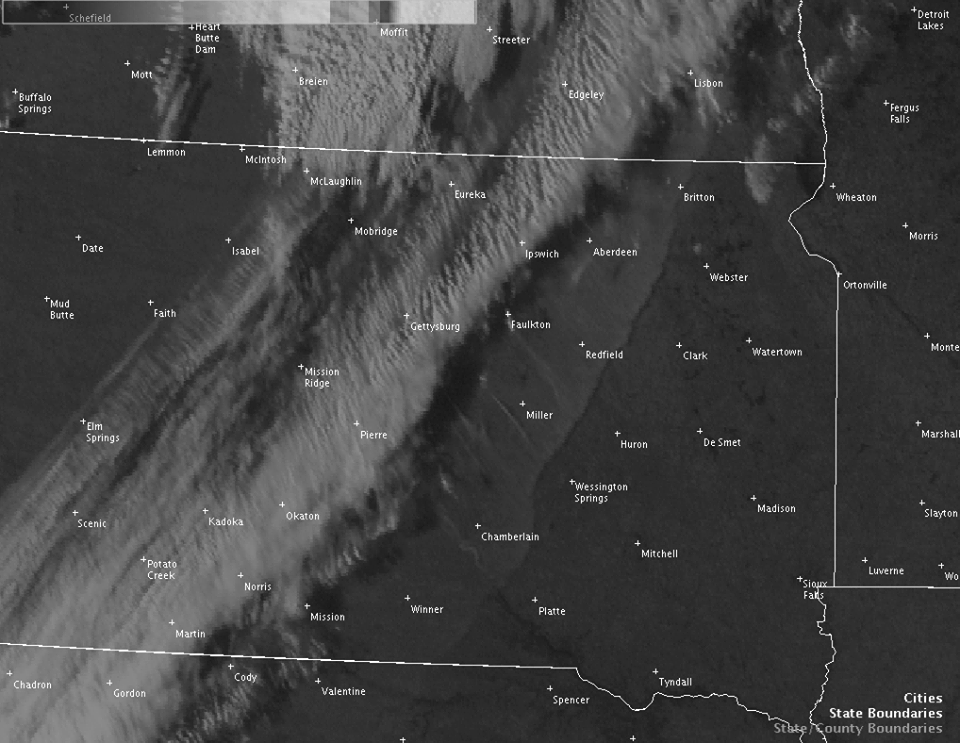
October 11 Dust Storm/Fires
This Sunday started out very warm with numerous record high temperatures in the mid and lower 90s, with Sisseton tying an all-time October high of 95 degrees. However, a strong cold front swept across the High Plains by the early evening and brought a drastic change in weather. Due to a relative dry stretch, high winds gusting predominantly in the 50-60 mph range kicked up a large area of blowing dust up several thousands of feet. Visibilities were reduced to less than a mile at times during the afternoon and evening hours of the 11th across the area as a result. But that wasn’t the last of our concerns that evening – a number of fires also got going due to the dry fuels and high winds. The visible satellite image below shows high clouds (left side), dust (transparent, right side), and smoke plumes (within the dust, streaking southeast).
Honorable mentions: High wind event November 18-19th, freeing rain/drizzle events in January, blizzard conditions January 8th, and the snowy December.
MONTHLY SUMMARIES
Below are summaries that address overall trends and events for each of the months in 2015.
January 2015
2015 began with average temperatures for January across central and northeast South Dakota as well as west central Minnesota being much above normal. Although, January started out very cold across the region with daily temperature departures of up to 20 to 25 degrees below normal from the 2nd through the 13th. Temperatures then warmed up to much above normal in the middle of the month and stayed that way through nearly the end of the month. From January 14th through January 30th, daily temperature departures were up to 20 to 25 degrees above normal. Across the region, the difference between the high and low temperatures for the month were anywhere from 60 to 80 degrees. Timber Lake had the greatest difference in January with a low 17 degrees below zero and a high of 64 degrees.
With the warm temperatures from mid to late January, there were a few rare rain and freezing rain events. Precipitation for the month varied from a half inch below normal to around a quarter inch above normal.
February 2015
After a few warm winter months, February had below to much below normal temperatures with average monthly temperatures ranging from 2 to as much as 9 degrees below normal. There was quite a range in temperatures across the region for February as mild Pacific air and bitter Arctic air battled it out, especially across central South Dakota. The differences between the high and low temperatures for the month were anywhere from 76 degrees at Mobridge to 87 degrees at Kennebec. In fact, all four locations in central South Dakota set record high temperatures on February 7th.
The abnormally dry conditions continued across the region mainly east of the Missouri river throughout February. Moderate drought conditions continued to be felt across a large part of northeast South Dakota. February precipitation was below normal for all locations except for Mobridge where it was slightly above normal for the month.
March 2015
March was a very warm and dry month with average temperatures ranging from 4 to 7 degrees above normal for the month. The average high temperatures across the region were from 7 to 13 degrees above normal being one of the warmest on record. Pierre had their second warmest average high temperature for March along with Timber Lake. Mobridge and Kennebec had their third warmest average high temperature on record. There was a large range from the highest to the lowest temperatures for March with below zero readings early on to the very warm readings in mid and late March. Differences between the high and low temperatures across the region ranged from 80 to over 100 degrees. Kennebec had a difference of 102 degrees with a low of 19 below zero on March 5th and a high of 83 degrees on March 15th.
The area was also very dry throughout March with precipitation departures ranging generally from three-quarters to an inch below normal. As a result, moderate drought conditions expanded across northeast South Dakota and west central Minnesota throughout March with abnormally dry conditions spreading out west. Several locations had one of their top ten driest March’s on record. Aberdeen and Mobridge tied for the tenth driest while Timber Lake had their fourth driest March on record. Timber Lake and Mobridge also tied for their second and third least snowfalls on record, respectively, with only a trace of snowfall.
April 2015
April was a very warm month with average temperatures ranging anywhere from 3 to 4 degrees above normal. While the average high temperatures across the region were from 4 to 7 degrees above normal, the average lows were within 1 to 2 degrees above normal.
The area was also very dry throughout April with precipitation departures across the region generally from an inch to nearly two inches below normal. As a result, moderate drought conditions expanded to include most of South Dakota. By the end of the month, severe drought conditions developed over a good portion of central South Dakota. Many locations had one of their top ten driest April’s on record. The Mellette area had their driest April on record with Roscoe having their 2nd driest April on record. Watertown, Kennebec, and Wilmot all had their 6th driest April on record. Aberdeen and Pierre had their 15th driest April on record.
May 2015
May was a very wet month across the region along with cooler than normal temperatures. Rainfall amounts were generally from 3 to over 9 inches or from 2 to over 6 inches above normal. Kennebec was the only location with just below normal rainfall. Pierre, Mobridge, Wheaton, and Aberdeen all had one of their top ten wettest Mays on record. In fact, the 9.32 inches at Mobridge was not only their wettest May on record, but also their wettest month of all-time. The previous wettest month on record for Mobridge was June 1915 when they received 8.85 inches of precipitation. The monthly rankings for the top ten are located in parentheses by the monthly precipitation amounts. The most interesting fact for the region was that drought covered much of the area at the beginning of the month with most of the area in moderate to severe drought. It is quite amazing how a drought can be eliminated or nearly eliminated over a short period of time. The unusual weather in May was the heavy snow that occurred across north central South Dakota with 6 to 12 inches of snow from May 9th into the 11th.
After several above normal temperature months, average temperatures for May were from 1 to 4 degrees below normal across the region. Later than average freezing temperatures also occurred across central and north central South Dakota when temperatures fell into the upper 20s at several locations.
June 2015
June was a warmer than normal month with average monthly temperatures anywhere from near normal to almost three and half degrees above normal. Precipitation across the region varied from above, near, to below normal ranging from 2.36 inches below at Sisseton to 2.59 inches above at Pierre. Pierre received over 6 inches of rain during June.
The highlights for severe weather took place in a back-to-back timeframe from June 19th through June 22nd. The beginning of the first one took place across Sully, Hand, and Hyde counties during the afternoon of the 19th with severe weather and flash flooding. Large hail up to 2 inches along with 5 to 6 inches of rainfall occurring in some locations with radar estimates much higher. During the night of June 19th and 20th, a squall line of severe thunderstorms produced winds of over 90 mph mainly across Jones, Lyman, and Buffalo counties mainly along Interstate-90. Numerous structures, campers, trees, semis, power lines, billboards, roads signs, grain bins, along with a trailer house were damaged or destroyed. There was a fatality when the trailer house was destroyed in Fort Thompson.
The other severe event came within 72 hours from Sunday evening June 21st through Monday morning June 22nd. First a bowing line of storms moved in from south central North Dakota impacting McPherson and Brown counties with hail up to baseball size at Richmond Lake. A couple supercells then tracked from Bath to Milbank producing large hail. The second shot during this event was the derecho, a particularly damaging and long-lived line of wind-producing thunderstorms that moved at 60 mph from western South Dakota into Stanley County. A wind gust of 122 mph was measured near Hayes, unofficially. One person was injured here as a camper rolled along with some grain bins destroyed and an office building moved. The storms raced east through Pierre and Fort Pierre with winds measured up to 81 mph at the Pierre Airport. Widespread damage occurred with countless trees downed, a flipped mobile home and semis, along with several buildings damaged. The storms then moved east to affect much of Lyman, Hyde, Hand, and Buffalo counties, the same counties that were affected a few days earlier. The storms went on to produce widespread wind damage through southeast South Dakota, southern Minnesota, northern Iowa, and Illinois through the morning and afternoon hours on the 22nd.
July 2015
July had near average temperatures across the region ranging from 1 degree below normal to 2 degrees above normal. Rainfall across the region was also not far from normal ranging from an inch above to nearly an inch below normal. The big severe weather event for the month came on July 17th when a surface low pressure area moving across South Dakota combined with a warm front lifting north and a cold front moving east to bring numerous severe thunderstorms to northeast South Dakota. Large hail up to the size of baseballs, damaging winds up to 100 mph, along with a few tornadoes affected much of northeast South Dakota. Tree, building, vehicle, and crop damage occurred along the path of the storms. The most significant damage occurred in Waubay and southeast of Waubay where many trees were downed. At the Bitter Lake Lodge campground, several campers were rolled and destroyed. A farm had a barn and several other outbuildings severely damaged along with empty grain bins destroyed. Also, much of the wheat and corn crop was completely destroyed. Many trees were downed in Waubay along with several damaged homes and downed power lines. A tornado also touched down southeast of Grenville causing some damage.
August 2015
August 2015 had near to just slightly below temperatures across central and northeast South Dakota as well as west central Minnesota. There were several periods of heat and high humidity throughout the month. The warmest temperatures for August were mainly in the 90s and lower 100s. Pierre reached 104 degrees on August 15th. Rainfall for August was generally near to above normal across the region. Monthly rainfall amounts were from near 2 to over 5 inches across the region with Watertown being over two and half inches above normal.
September 2015
September was a very warm and dry month across most of central and northeast South Dakota as well as west central Minnesota. All locations except for Pierre had one of their top ten warmest Septembers on record. Average temperatures were anywhere from four to seven degrees above normal for the month. Timber Lake had their second warmest September on record while Mobridge had their third warmest. Average September temperatures for Watertown were the fourth warmest with Sisseton the fifth warmest on record. Finally, Aberdeen and Kennebec had their eighth and ninth warmest Septembers on record, respectively. Highs for the month were in the 90s with Pierre reaching 100 degrees on the third. Also, no freezing temperatures occurred at each of the locations with lows only in the mid to upper 30s for the month.
As far as precipitation, all locations had below normal rainfall except for Kennebec. Locations in northeast South Dakota and west central Minnesota were very dry with rainfall amounts all under one inch or from nearly two to two and half inches below normal.
October 2015
October was another very warm month with average temperatures ranging from 4 to 6 degrees above normal. Aberdeen, Mobridge and Timber Lake all set record highs on the 10th and the 11th while Pierre and Sisseton set record highs on the 11th. Wheaton, Minnesota broke their record high with 95 degrees on the 12th, and it tied for their 2nd warmest October temperature on record. Sisseton tied their all-time record high for the month of October with 95 degrees, previously set on October 10th 1955. With the very warm temperatures, most locations had one their top twentieth warmest Octobers on record. Kennebec, Mobridge, and Timber Lake all had one of their top ten warmest Octobers on record with Timber Lake having their eighth warmest October on record. With these warmer than normal temperatures, a hard freeze held off across the region until the middle of October.
Drought conditions expanded some across the northern part of our region throughout the month before a widespread rainfall event occurred from the 22nd through the 24th. A strong area of low pressure lifting across the region brought anywhere from a half inch to nearly two inches of rainfall. Despite this rainfall, monthly averages were still below normal across the region ranging from a third of an inch below to almost one and quarter inches below normal. Also, several locations had some snow showers towards the end of the month on October 28th.
November 2015
November 2015 was a very warm month with monthly average temperatures ranging from 3 to almost 9 degrees above normal across the region. It was interesting that Aberdeen, Sisseton, Watertown and Wheaton, Minnesota were nearly as warm or warmer than Kennebec and Pierre in central South Dakota. This does not happen very often for anytime of the year. As a result, all locations in northeast South Dakota and west central Minnesota had one of their top ten warmest Novembers of all-time. Watertown tied for the fourth warmest while Sisseton had their ninth warmest November on record. Wheaton had its sixth warmest November while Aberdeen had its tenth warmest November on record. Some record highs also occurred at Aberdeen and Mobridge on November 14th. The warmer temperatures were due in part to the lack of snow cover across the region along with El Nino.
The monthly precipitation across the region was generally from a quarter of an inch to three quarters of an inch above normal. Most of the precipitation was rainfall, which, for our region, would normally be snowfall. Timber Lake was the only location with below normal precipitation. An intense surface low pressure area brought good coverage of rainfall on the 18th and 19th along with very strong northwest winds. Many locations received from a half inch to over an inch of rainfall with high wind gusts from 50 to nearly 80 mph. The snowfall mainly came at the end of November into the first of December as a large upper level pressure system affected the region. This snowstorm brought anywhere from 3 to 10 inches of snow across the region.
December 2015
December 2015 featured above average temperatures, which has become a monthly theme for the year. Though not in record territory, locations ranged from 4-8 degrees above normal for the month. The first half of December was particularly warm, but temperatures became increasingly seasonable as the month wrapped up. It took until mid to late December for low temperatures to first reach at least 0 degrees for many. On the 27th Pierre’s streak was broken, but not before coming within 5 days of reaching their record latest first 0 degrees or colder temperature.
These warm temperatures prevailed despite an active pattern which brought several rounds of moderate to heavy snow across the area, which typically entrenches cold air across the region this time of year. Snowstorms took place on Nov 30-Dec 1st, Dec 15-16th, and then again from Dec 25-26th. Although these events weren’t particularly extreme in terms of cold, wind, or ice, they combined to reach impressive monthly snowfall totals across parts of central South Dakota. Murdo observed their snowiest December on record, while Pierre was 4th and Kennebec tied for 5th. These numbers are unusual considering a strong El Nino is in progress, though El Nino is but one climatic factor that influences our winters.
|
2015 CLIMATE REVIEW |
||||
|
Temperature Data |
Aberdeen |
Sisseton |
Wheaton |
Watertown |
|
Warmest Temperature/Date |
98/June 9th |
97/June 9th +July 12th |
95/July 13th +Oct 12th |
96/June 9th |
|
Coldest Temperature/Date |
-20/Feb 27th |
-15/Jan 12th +Feb 22nd |
-17/Feb 23rd |
-18/Mar 5th |
|
Average Yearly High/Departure from Normal |
58.8/+4.2 |
57.3/+2.8 |
55.4/+2.5 |
56.5/+2.9 |
|
Average Yearly Low/Departure from Normal |
33.7/+2.2 |
34.9/+1.9 |
34.4/+2.3 |
35.2/+2.7 |
|
Yearly Average/Departure from Normal |
46.3/+3.3 |
46.1/+2.4 |
44.9/+2.4 |
45.8/+2.8 |
|
Precipitation/Wind Data |
||||
|
Yearly Precipitation / Departure from Normal |
21.18/-0.54 |
17.93/-4.40 |
21.83/-0.55 |
21.42/-0.66 |
|
Highest Wind Gust MPH / Date |
64/June 21st |
60/Nov 18th |
N/A |
56/Nov 18th |
|
Temperature Data |
Pierre |
Kennebec |
Mobridge |
Timber Lake |
|
Warmest Temperature/Date |
104/Aug 15th |
101/July 23+24th +Aug 15+16th |
99/Aug 15th +Sept 3rd |
102/Aug 15th |
|
Coldest Temperature/Date |
-11/Jan 5th +Jan 12th |
-19/Mar 5th |
-17/Jan 5th |
-17/Jan 5th |
|
Average Yearly High/Departure from Normal |
61.5/+2.3 |
64.6/+3.5 |
60.7/+3.9 |
60.5/+3.2 |
|
Average Yearly Low/Departure from Normal |
36.2/+0.6 |
36.6/+1.2 |
35.9/+2.8 |
35.5/+1.9 |
|
Yearly Average/Departure from Normal |
48.9/+1.5 |
50.6/+2.4 |
48.3/+3.4 |
48.0/+2.5 |
|
Precipitation/Wind Data |
||||
|
Yearly Precipitation / Departure from Normal |
22.50/+2.49 |
18.16/+0.80 |
23.33/+5.46 |
16.70/-0.91 |
|
Highest Wind Gust MPH / Date |
80/Jun 22nd |
N/A |
61/Nov 18 |
N/A |

