Wildfire smoke continues to impact air quality from the Great Lakes region into New England and the Mid-Atlantic today with widespread Air Quality Alerts in effect. Severe thunderstorms are expected across portions of the Ohio Valley and Lower Great Lakes into the Mid-Atlantic and Northeast, this afternoon into the evening. Monsoonal thunderstorms may bring areas of flooding to the Southwest. Read More >
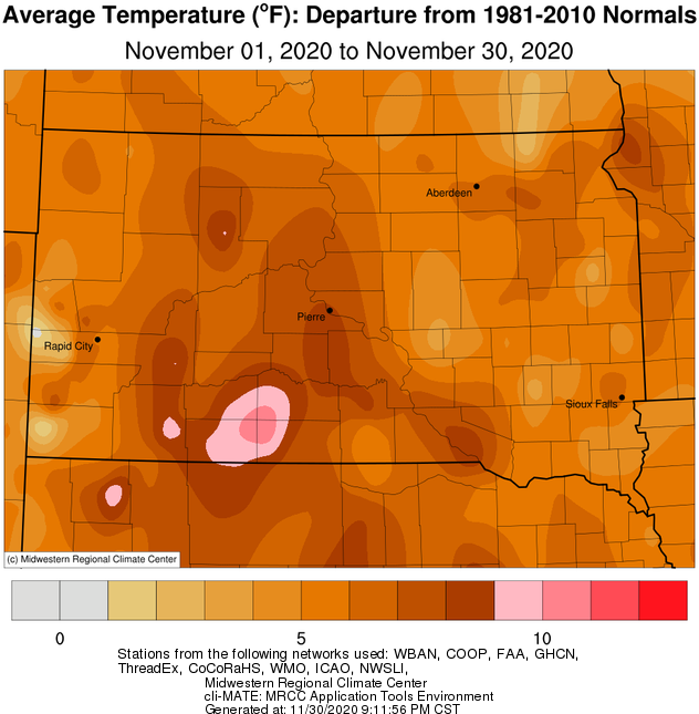
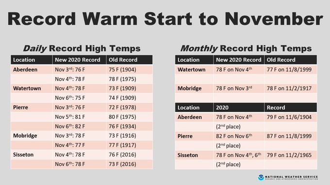
The whole region observed much above average temperatures on a whole this November, of generally between 6 to 9 degrees. A plethora of record-setting warm days early on, in particular, resulted in the 5th warmest first week of November on record in Aberdeen, 4th at Watertown, Mobridge and Sisseton, and 3rd at Pierre. See the graphic further down the page for a listing of records through the first week of November at our Automated Surface Observation Station (ASOS) sites, including a couple monthly records. Additional warm temperature records set throughout the month not in that graphic include a tied monthly record of 81 F in Wheaton on the 5th (Nov 1st in 1950), a daily record of 60 F at ABR on 28th (59 in 1949), 59 F at 8D3 on the 28th (55 in 1949), a record warm low of 36 F at PIR on 18th (36 in 2019), record warm low of 44 F at ATY on the 8th (43 in 2006), and a record warm low of 35 F at MBG on 18th (34 in 1976). On a whole, the month finished as the 10th warmest on record in Mobridge, 8th warmest November on record in Kennebec, and tied 4th at Wheaton.
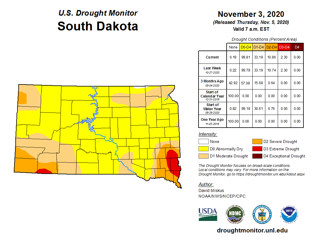
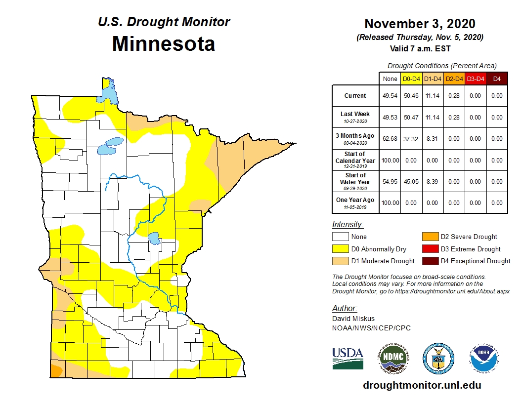
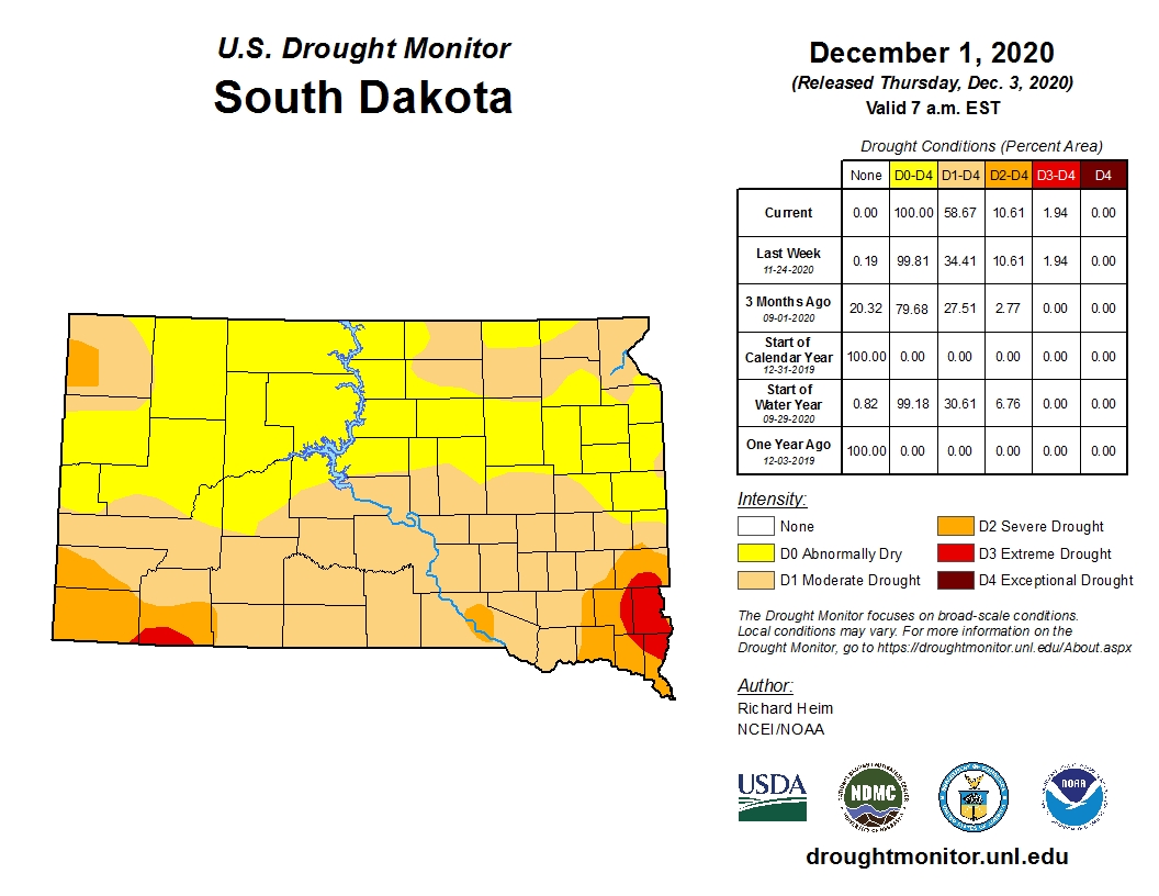
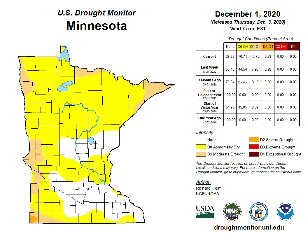
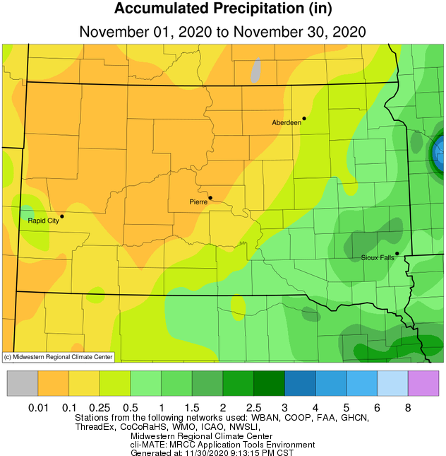
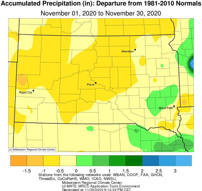
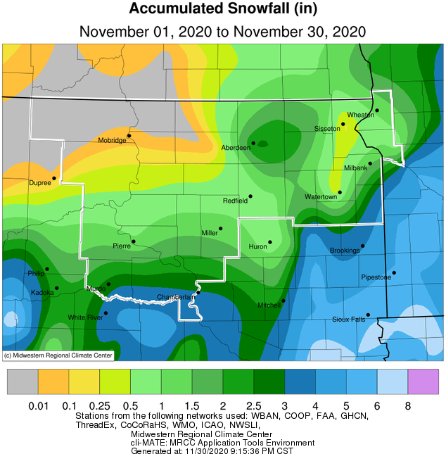
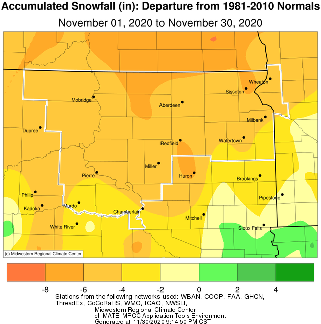
With just a trace or less of moisture/snowfall, November 2020 will go down as one of the driest on record for several locations across Central South Dakota. Specifically, just a trace of moisture fell over the 30 day period at Timber Lake and Mobridge, and just a trace of snow was observed at Wheaton and Mobridge. Timber Lake tied their least snowy November on record with zero snow. This, on the heels of a record-setting snowy October. As a result of the dry pattern, D1/Moderate Drought expanded to include much of the southern half of South Dakota by the end of the month, while remaining largely unchanged across portions of northeastern South Dakota and west central Minnesota. Far northeastern/eastern South Dakota and west central Minnesota did observe a more typical November in terms of precipitation, though snowfall was still below normal. Those in and around Deuel County picked up the most snow, as a couple systems with multiple inches of snow clipped that area. A daily snowfall record of 2.4” was set at Aberdeen on the 9th (2.0 in 1982) as well.
|
November 2020 |
||||
|
Temperature Data |
Aberdeen |
Sisseton |
Wheaton |
Watertown |
|
Warmest Temperature / Date |
78 / 4th |
78 / 4, 6th |
81 / 4th |
78 / 4th |
|
Coldest Temperature / Date |
5 / 30th |
11 / 30th |
14 / 30th |
8 / 30th |
|
Average High / Departure from Normal |
51.3 / +11.7 |
49.5 / +9.3 |
49.4 / +10.8 |
47.5 / +8.5 |
|
Average Low / Departure from Normal |
21.3 / +2.4 |
26.0 / +4.5 |
27.9 / +7.5 |
24.2 / +3.6 |
|
Monthly Average / Departure from Normal |
36.3 / +7.0 |
37.7 / +6.9 |
38.7 / +9.2 |
35.8 / +6.0 |
|
Precipitation Data |
|
|
|
|
|
Monthly Precipitation / Departure from Normal |
0.36 / -0.37 |
0.49 / -0.09 |
0.69 / -0.44 |
0.99 / +0.23 |
|
Most Precipitation in 24 hours / Date |
0.20 / 9th |
0.29 / 9th |
0.47 / 9th |
0.75 / 9th |
|
Monthly Snowfall / Departure from Normal |
2.7 / -4.3 |
0.1 / -7.2 |
T / -4.6 |
0.1 / -4.8 |
|
Most Snow in 24 hours / Date |
2.4 / 9th |
0.1 / 9th |
T / 10,15,22,23rd |
0.1 / 10th |
|
Temperature Data |
Pierre |
Kennebec |
Mobridge |
Timber Lake |
|
Warmest Temperature / Date |
82 / 6th |
83 / 6th |
78 / 3rd |
74 / 3rd |
|
Coldest Temperature / Date |
7 / 30th |
4 / 30th |
10 / 30th |
11 / 12th |
|
Average High / Departure from Normal |
54.6 / +10.5 |
57.0 / +11.5 |
52.9 / +10.1 |
51.3 / +9.4 |
|
Average Low / Departure from Normal |
25.4 / +2.1 |
24.7 / +2.1 |
23.8 / +2.7 |
24.4 / +3.2 |
|
Monthly Average / Departure from Normal |
40.0 / +6.3 |
41.1 / +7.1 |
38.3 / +6.4 |
38.1 / +6.5 |
|
Precipitation Data |
|
|
|
|
|
Monthly Precipitation / Departure from Normal |
0.07 / -0.69 |
0.14 / -0.58 |
T / -0.48 |
T / -0.61 |
|
Most Precipitation in 24 hours / Date |
0.07 / 12th |
0.14 / 9th |
T / 8,16,19th |
T / 8, 19th |
|
Monthly Snowfall / Departure from Normal |
1.0 / -4.3 |
2.0 / -4.3 |
T / -4.7 |
0.0 / -5.9 |
|
Most Snow in 24 hours / Date |
1.0 / 12th |
2.0 / 9th |
T / 16th |
N/A |
Average temperature departures in November, courtesy of the Midwestern Regional Climate Center
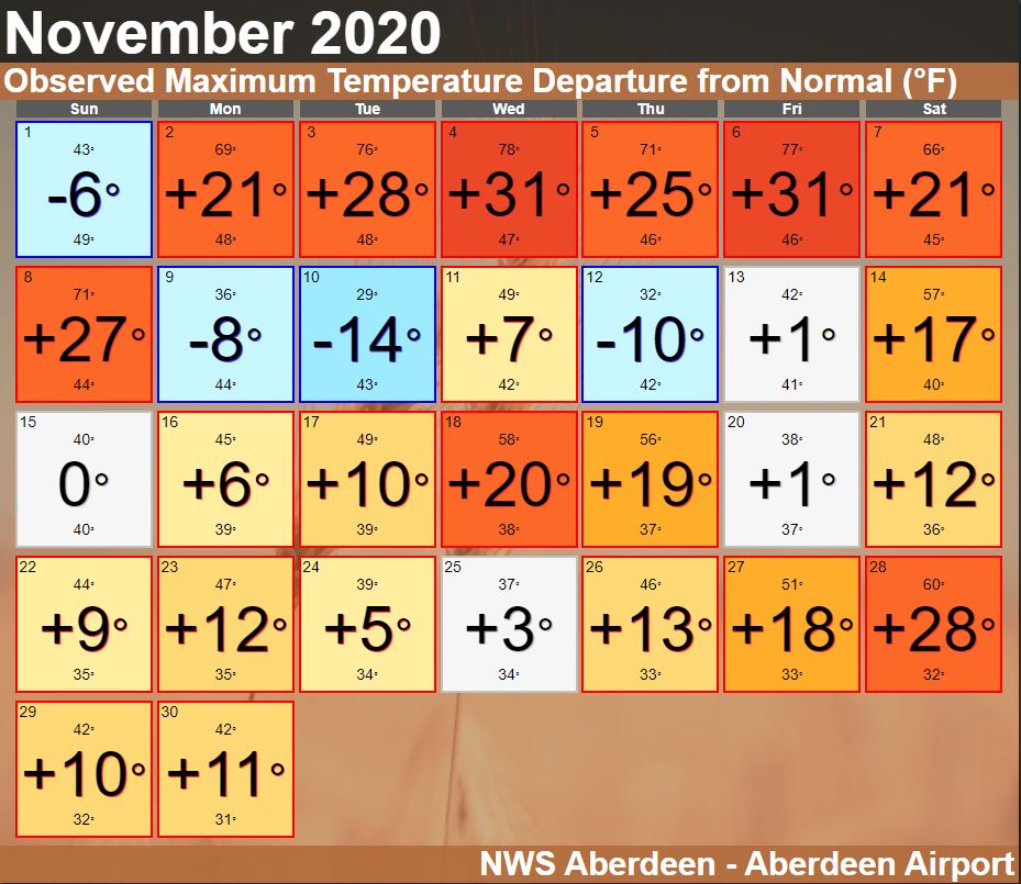
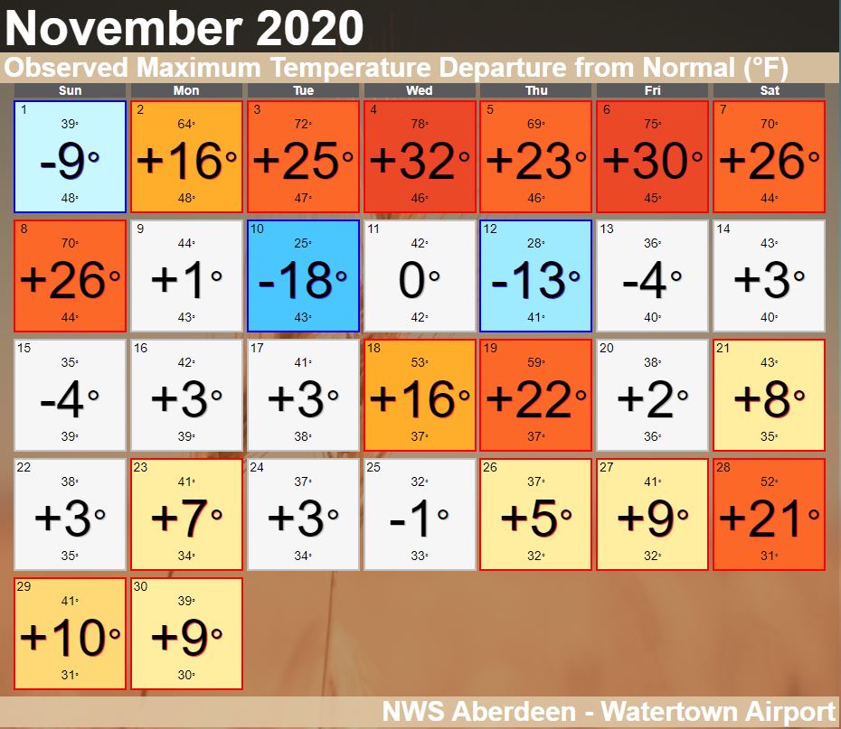
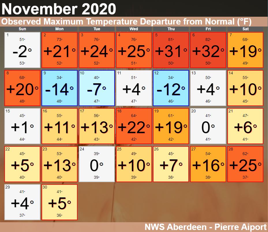
Daily high temperature departures throughout November at Aberdeen, Watertown and Pierre (in that order from top left to bottom left) to depict when the warmest of the weather occurred.
Records set during the first week of November at our 5 Automated Surface Observing Station locations (Aberdeen, Watertown, Pierre, Mobridge and Sisseton).
Observed precipitation (left) and departures from normal (right) in November, courtesy of the Midwestern Regional Climate Center
Observed snowfall (left) and departures from normal (right) in November, courtesy of the Midwestern Regional Climate Center
US Drought Monitor highlighting areas of abnormal dryness and drought across South Dakota and Minnesota on November 3rd (top) and December 1st (bottom).