Summary/Highlights: During the early morning hours of Wednesday, 28 August 2013, a line of severe thunderstorms produced significant wind damage across portions of central and east-central South Dakota. The hardest hit area appeared to be southern Spink County, where significant tree and property damage occurred between about 530am and 7am CDT. A NWS Storm Survey Team was dispatched to the area on Wednesday afternoon to assess the magnitude and extent of the damage. The worst damage appeared to begin near Cottonwood Lake in western Spink County. Widespread tree damage was sustained with several uprooted trees and many large branches down. Several residences and cabins along the lake suffered moderate to extensive damage. One camping trailer on the west side of the lake rolled approximately 50 yards into the lake and was a total loss. Damage in this area all appeared to be oriented from west/northwest to east/southeast. This is consistent with straight-line wind damage with estimated wind speeds of 70 to 90 mph. The survey team then continued eastward towards Tulare. Scattered tree damage was noted along the route with several uprooted trees. Several corn and bean fields were either damaged or destroyed by a combination of wind and hail. Again, all the damage appeared to be oriented from northwest to southeast – consistent with straight-line wind damage. Wind damage here was estimated between 70 and 80 mph. Finally, the team examined damage in and around the community of Tulare. Minor to moderate property damage was noted on several residences including roof damage to the local high school. Widespread tree damage occurred with several large trees uprooted or snapped at their base. All damage near Tulare was also determined to be straight line wind damage – with peak winds speeds estimated to be as high as 90 to 100 mph. In addition, a local mesonet station in Tulare confirmed these speeds with a peak measured wind gust of 91 mph. This information was collected from the combined effort by the National Weather Service and Spink County Emergency Management. The latest Local Storm Report Summary issued by the NWS Aberdeen forecast office can be found below or by clicking the link HERE. |
|
|
|
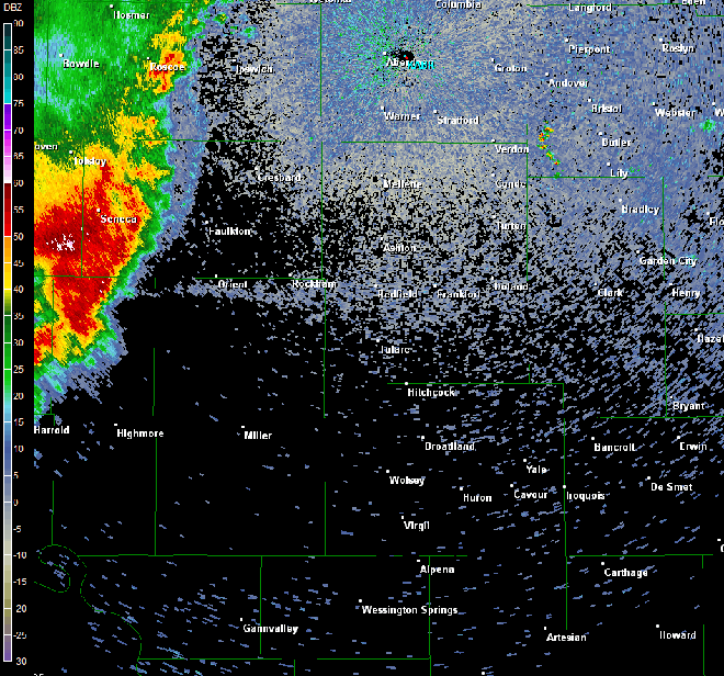
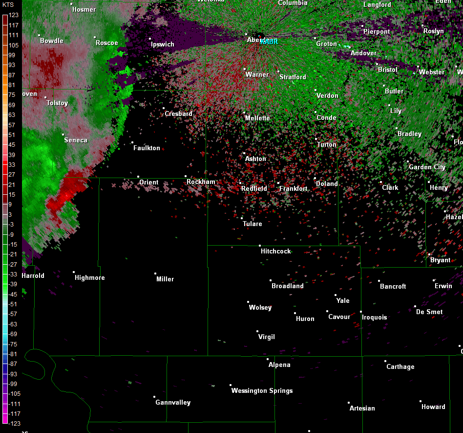
KABR Radar Loops:
0.5 Base Reflectivity and Velocity (500am CDT – 730am CDT)
Summary of Storm Reports:
PRELIMINARY LOCAL STORM REPORT...SUMMARY
NATIONAL WEATHER SERVICE ABERDEEN SD
148 PM CDT WED AUG 28 2013

..TIME...   ...EVENT...      ...CITY LOCATION...     ...LAT.LON...
..DATE...   ....MAG....      ..COUNTY LOCATION..ST.. ...SOURCE....
            ..REMARKS..

0700 PM     TSTM WND DMG     12 S MCINTOSH           45.75N 101.35W
08/27/2013                   CORSON             SD   PUBLIC

            PUBLIC REPORTS WIND DAMAGE TO GRAIN BINS AND TREES.

0715 PM     TSTM WND GST     BULLHEAD                45.77N 101.08W
08/27/2013  E60 MPH          CORSON             SD   TRAINED SPOTTER

            SMALL TREES BLOWN OVER.

1100 PM     HAIL             2 SE ISABEL             45.37N 101.40W
08/27/2013  E1.00 INCH       DEWEY              SD   PUBLIC

            RESIDENT REPORTED LOTS OF HAIL... WITH SEVERAL QUARTER
            SIZED STONES

1101 PM     TSTM WND GST     3 SSW WHITLOCKS BAY REC 45.01N 100.29W
08/27/2013  M59 MPH          POTTER             SD   MESONET

1215 AM     HAIL             3 S FIRESTEEL           45.38N 101.28W
08/28/2013  E1.00 INCH       DEWEY              SD   TRAINED SPOTTER

1250 AM     TSTM WND GST     10 ESE TIMBER LAKE      45.37N 100.88W
08/28/2013  E60 MPH          DEWEY              SD   PUBLIC

            SMALL HAIL WITH 50-60 MPH WINDS

0400 AM     TSTM WND GST     3 SSW WHITLOCKS BAY REC 45.01N 100.29W
08/28/2013  M67 MPH          POTTER             SD   MESONET

            PEAK WIND GUST MEASURED FROM THE FOREST CITY RWIS.

0415 AM     TSTM WND GST     1 S GETTYSBURG          44.99N  99.95W
08/28/2013  M69 MPH          POTTER             SD   MESONET

            K0D8 GETTYSBURG SUPERAWOS

0520 AM     TSTM WND GST     6 SW ORIENT             44.84N  99.17W
08/28/2013  E70 MPH          HAND               SD   PUBLIC

            LARGE COTTONWOODS SNAPPED IN TWO ESTIMATE 60-70 MPH
            WINDS

0540 AM     TSTM WND GST     MIRANDA                 44.97N  98.96W
08/28/2013  M80 MPH          FAULK              SD   MESONET

            PEAK WIND GUST MEASURED FROM THE MIRANDA RWIS.

0605 AM     TSTM WND DMG     8 SSE ZELL              44.79N  98.66W
08/28/2013                   SPINK              SD   EMERGENCY MNGR

            NUMEROUS 2 FT TREES SNAPPED AT BASE... GARAGE DESTROYED
            AND LAID ACROSS FIELD... AND CAMPERS TIPPED ON EAST SIDE
            OF COTTONWOOD LAKE

0620 AM     TSTM WND GST     TULARE                  44.74N  98.51W
08/28/2013  M91 MPH          SPINK              SD   PUBLIC

            HOME WIND SYSTEM

0623 AM     TSTM WND DMG     TULARE                  44.74N  98.51W
08/28/2013                   SPINK              SD   PUBLIC

            SEVERAL TREES DOWN AND WINDOWS BLOWN OUT OF HOMES IN
            TULARE.

0625 AM     TSTM WND DMG     TULARE                  44.74N  98.51W
08/28/2013                   SPINK              SD   NWS EMPLOYEE

            ROOF DAMAGE TO LOCAL SCHOOL

0645 AM     TSTM WND DMG     7 ENE TULARE            44.78N  98.38W
08/28/2013                   SPINK              SD   PUBLIC

            TREES AND TREE BRANCHES DOWN ESTIMATED WIND 60-70 MPH
            POWER IN AND OUT

0735 AM     TSTM WND GST     2 S WILLOW LAKE         44.60N  97.64W
08/28/2013  E70 MPH          CLARK              SD   PUBLIC

            GRAIN BINS ROLLED CORN FLATTENED PEA TO DIME SIZE HAIL


&&

