Heavy lake effect snow and gusty winds, including some local blizzard conditions, will continue into Thanksgiving Day across the Great Lakes then lingering through Friday night for Lakes Erie and Ontario. Confidence is increasing for another winter storm to develop over the northern and central Rockies Friday and track across the central Plains through the Midwest and Great Lakes this weekend. Read More >
Overview
|
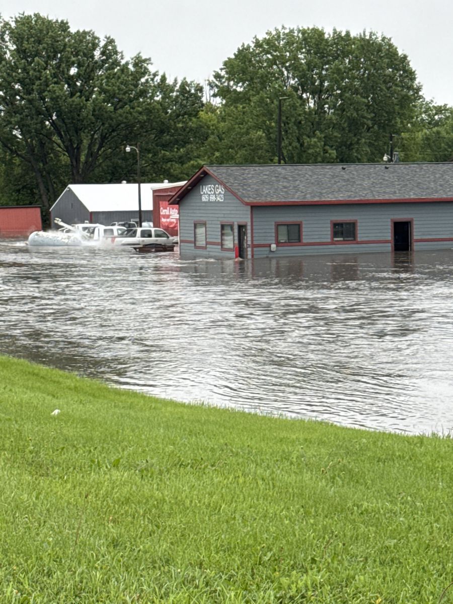
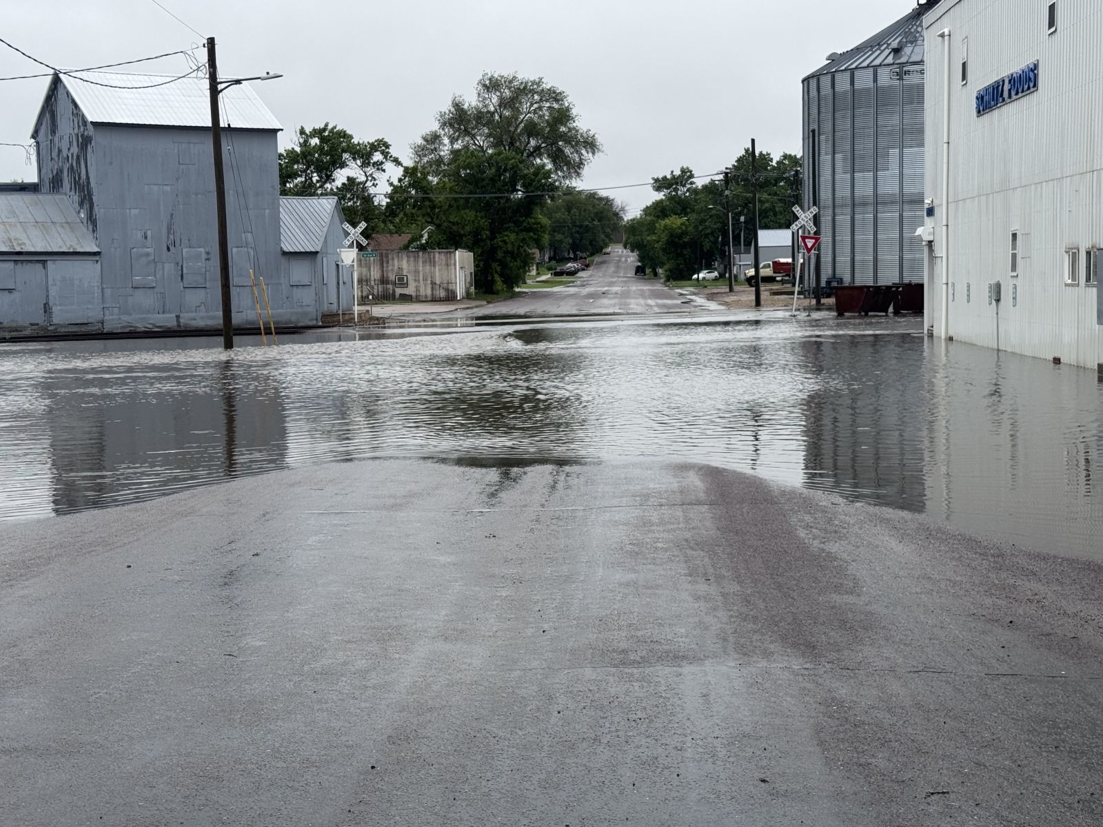
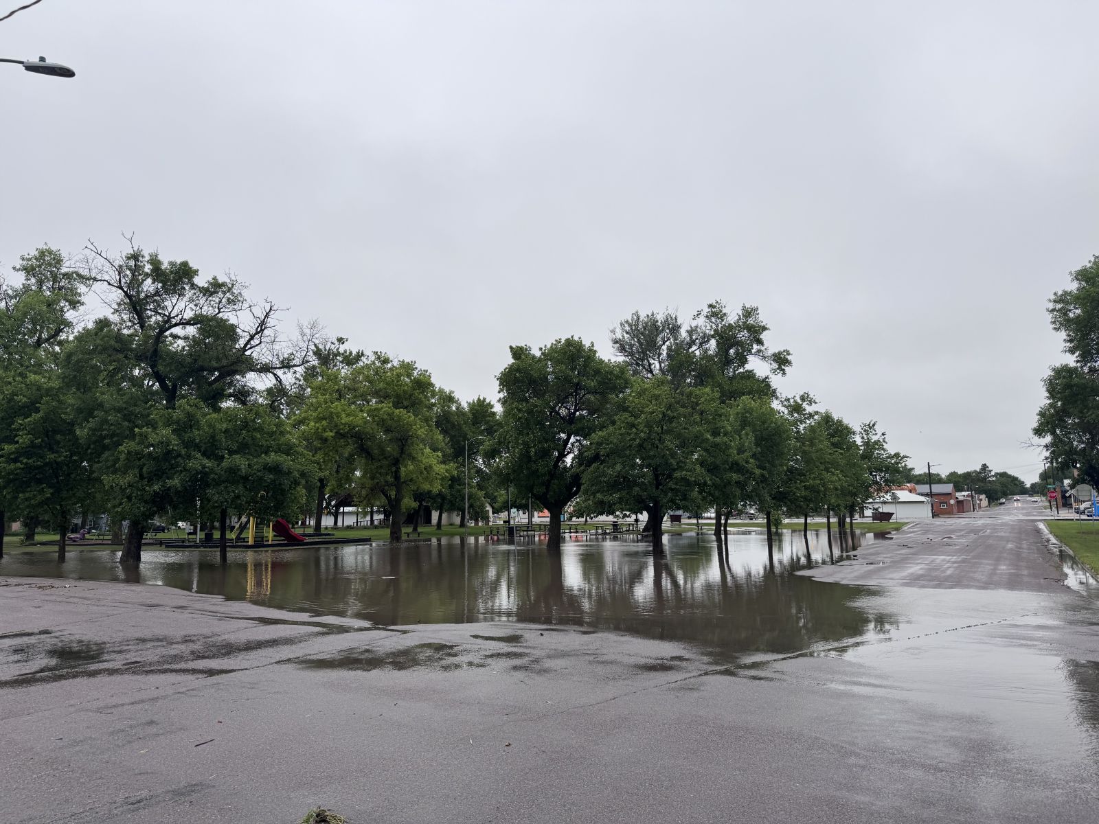
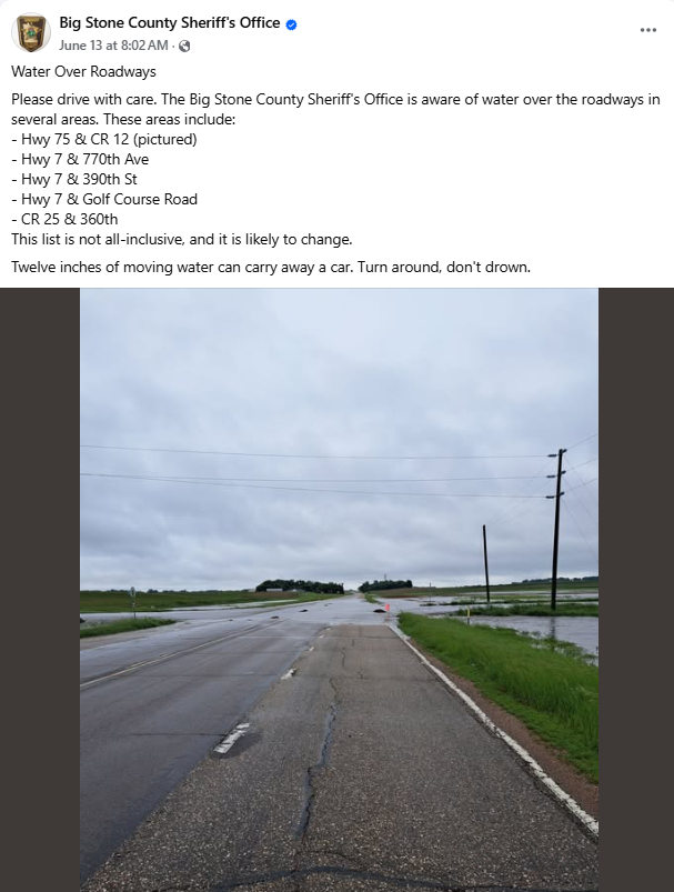
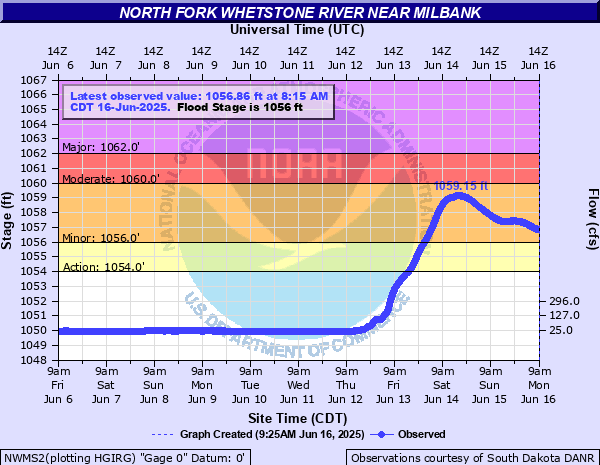
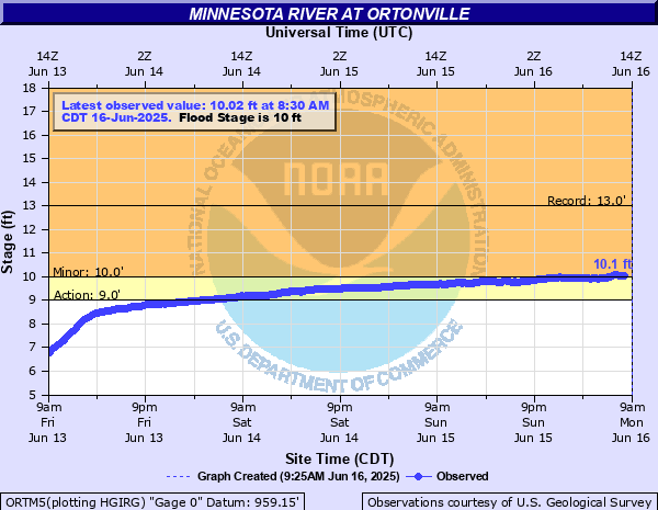
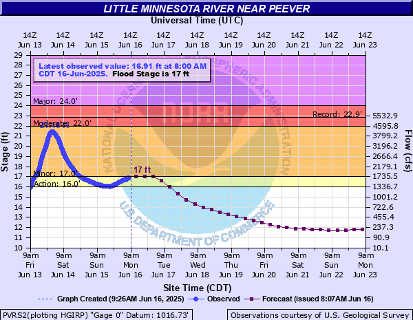
Thunderstorms developed along and north of a warm front on June 12. These storms repeatedly moved over the same areas for several hours through the evening of June 12 into the morning of June 13. The "training" nature of the storms resulted in significant rainfall accumulations across northeast South Dakota and west central Minnesota. Some areas received over 6 to 7 inches of rain, leading to subsequent flooding. Marshall and Roberts Counties in South Dakota, along with Big Stone County in Minnesota, experienced the most significant impacts. Many secondary highways were closed due to water over the road. Buildings and vehicles took on water on the southeast side of Sisseton, particularly near the Lakes Gas business. Water also rose rapidly on rivers and lakes. Gauging stations on the North Fork Whetstone River near Milbank, the Minnesota River at Ortonville, and the Little Minnesota River near Peever all rose into minor flood stage. Big Stone Lake levels also increased quickly, submerging many docks. Additional thunderstorms would occur June 15-16, adding to the already saturated grounds and flood situation. Some storms would produce quarter size hail and 60-73 mph wind gusts. |
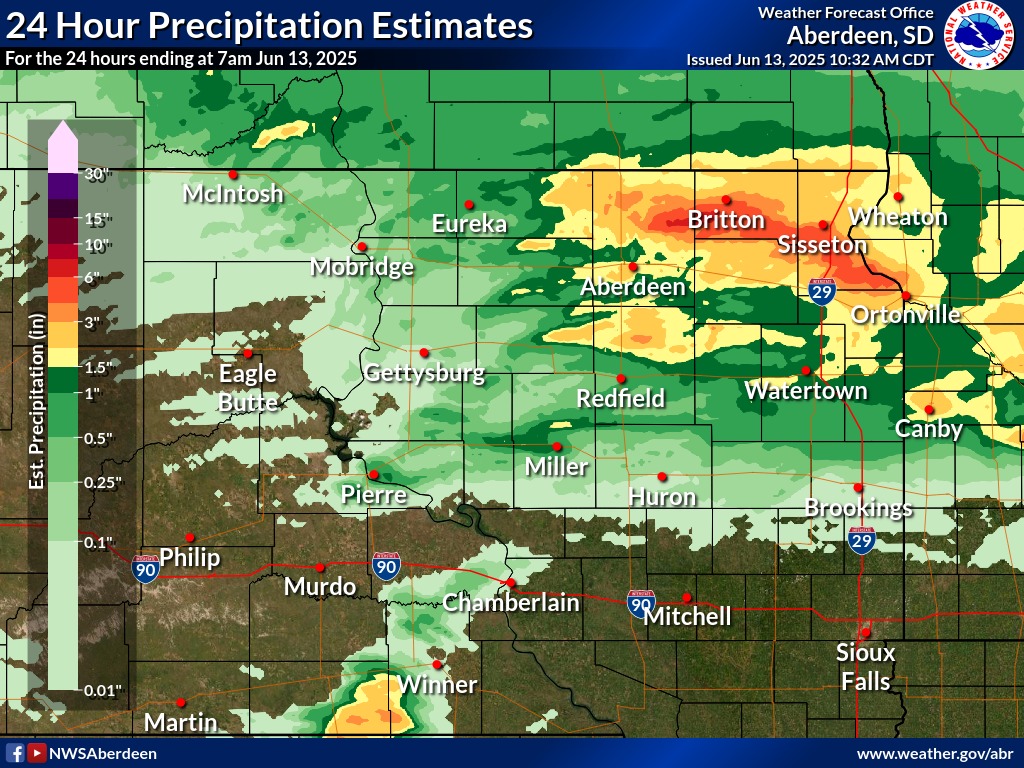 24 Hour Precipitation Estimates Ending at 7 AM June 13 |
Radar
Header
| KABR Radar Imagery ~2:00 AM to 4:00 AM Central | KABR Radar Imagery ~4:00 AM to 6:00 AM Central |
Photos & Video
Header
|
||||||||||||||||
| USGS timelapse of Little Minnesota River at Peever after rainfall on June 12th into the 13th. |
Storm Reports
| Location | Rainfall Totals from the 12th to 16th | Greatest 24hr Rainfall Total and Date |
|---|---|---|
| Wilmot | 6.72 inches | 5.60 in/ 13th |
| Big Stone City 5 WNW | 6.28 inches | 4.97 in/ 13th |
| Sisseton COOP | 5.85 inches | 3.12 in/ 13th |
| Lake City 4 SW | 5.62 inches | 5.25 in/ 13th |
| Sisseton 10 ENE | 5.53 inches | 4.18 in/13th |
| Sisseton 4W | 5.46 inches | 4.63 in/ 13th |
| Milbank | 4.93 inches | 2.92 in/ 13th |
| Milbank 2 WSW | 4.92 inches | 2.90 in/ 13th |
| Milbank 4 SSW | 4.89 inches | 2.64 in/ 13th |
| Sisseton Airport | 4.63 inches | 2.19 in/ 13th |
| Appleton, MN, 4W | 4.55 inches | 3.58 in/ 13th |
| Britton | 4.53 inches | 4.35 in/ 13th |
| Artichoke Lake | 4.46 inches | 2.62 in/ 13th |
| Sand Lake | 3.85 inches | 3.70 in/ 13th |
| Victor 4N | 3.17 inches | 2.25 in/ 13th |
| Columbia | 3.01 inches | 2.78 in/ 13th |
| Summit | 2.53 inches | 1.48 in/ 13th |
| Aberdeen Airport | 2.05 inches | 1.84 in/ 12th |
| Location | Greatest 24hr Total and Date |
|---|---|
| Claremont | 7.06 in/ 13th |
 |
Media use of NWS Web News Stories is encouraged! Please acknowledge the NWS as the source of any news information accessed from this site. |
|