
Numerous severe thunderstorms are expected across a broad region from the Ohio Valley to the Mid-Atlantic and Northeast States today into tonight. Swaths of damaging wind gusts are expected and some tornadoes are possible. Bertha is expected to bring tropical storm conditions to portions of the Gulf Coast from the Florida Panhandle westward to southeastern Louisiana later today and Wednesday. Read More >
From the Science Corner:
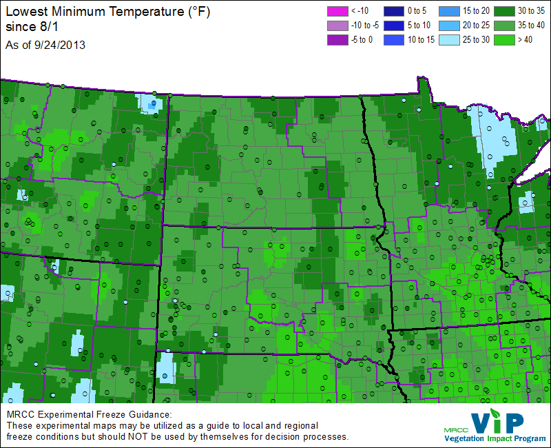
With the passing of the fall equinox on September 22nd, 2013 freezing temperatures will eventually occur over all of the Dakota's and Minnesota. In fact, temperatures in a few locations in South Dakota have already fallen into the mid-30s with a few locations in northern Minnesota dropping into the 20s. The image below depicts the lowest temperatures recorded so far this fall (thru Sept 24):
One question that commonly arises with regards to frost formation:
The official low temperature in "My Town" was warmer than freezing (32F) but I still saw frost. How does frost form when the low temperature does not fall below freezing?
There can be several reasons for this. First, low temperatures can vary significantly over short distances. For example, lower elevations such as valleys or river bottoms are often signifcantly cooler than higher elevations such as hills or ridgetops. So while the "official temperature" at a specific city (usually recorded at the airport) might have been 36F - the temperature in your neighborhood could be several degrees cooler.
Second, the height you are measuring the temperature is also very important! In other words, what is important is the temperature where the frost actually formed (e.g. near the ground). On certain nights, the temperature at the thermometer level (a few feet above ground) remains slightly above freezing, while temperature where the frost forms is in fact at or below freezing!
The height of the thermometer on most weather stations is taken 2-meters (or about 6 feet) above ground level (AGL). Because cold air sinks relative to warm air, and because the ground radiates heat very efficiently during calm, clear nights, the temperature at or near ground level can often be several degrees cooler than the temperature at the 2-meter thermometer height. To illustrate this example, the NWS in Aberdeen conducted a simple experiment back on October 2nd, 2008 - during a night with clear calm conditions. One thermometer recorded temperatures at the standard 2-meter level, while a second thermometer was placed near ground level (directly below). The temperature trace of both thermometers is shown from during the period 3pm on October 1st, through 8am on October 2nd.
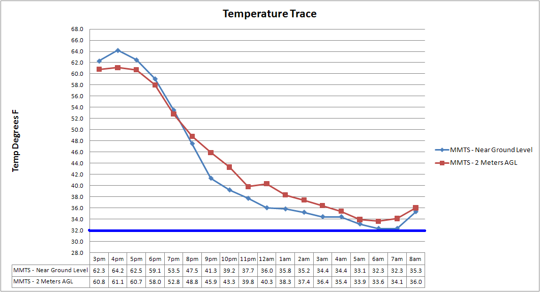
Note that the temperature 2-meters AGL (red trace) reaches a low temperature of 34 degrees F at 6am, while the sensor near ground level (blue trace) does indeed fall to 32 degree F from 6 to 7 am. So, while temperatures remained slightly above freezing a few feet above the ground, temperatures near the ground did in fact fall to freezing – allowing areas of frost to form. Science in action!
What about my car or roof – they are above the ground and there was frost on them as well this morning?
Certain materials like metal and glass radiate heat very efficiently, and therefore readily cool to the frost point. In addition, cars and rooftops are often better exposed (from multiple planes) and thus radiate heat more quickly than other objects. It should be noted that other meteorological factors such as wind speed and moisture also come into play when assessing the potential for frost. Subtle changes in these values can also be factors why one area sees frost and another nearby location does not. For instance, even a light wind speed of 3-5 mph can keep the atmosphere "mixed," thus preventing widespread frost formation.
Mike Fowle - SOO

