The persistent heat wave over much of the central and northern U.S. came to an end on Wednesday (7/20) as a weak cold front moved across the area. This cold front dropped temperatures back to near mid-July averages, and more importantly brought a much drier airmass into the region. For an interesting visual animation of this heat wave over the U.S., click HERE.
Below are a several other interesting facts about this recent heat wave:
|
City |
Maximum Dewpoint Temperature |
Date/Time |
|
Sisseton |
83 F |
7/17/11 – 5PM CDT |
|
Aberdeen |
82 F |
7/17/11 – 9 PM CDT |
|
Wheaton, MN |
82 F |
7/17/11 – 115 PM CDT |
|
Pierre |
80 F |
7/16/11 - 8 PM CDT* |
|
Mobridge |
80 F |
7/18/11 – 10 PM CDT* |
|
Watertown |
80 F |
7/19/11 – 1 AM CDT* |
* Multiple cccurrences of this value. The date/time of the last occurrence is noted.
|
City |
High Temperature (Date) |
Date of Last 100F Temperature |
|
Aberdeen |
100 F (7/19/11) |
July 7, 2007 |
|
Pierre |
101 F (7/19/11) |
August 27, 2010 |
|
Mobridge |
100 F (7/17/11) |
August 27, 2010 |
|
Timber Lake |
100 F (7/19/11) |
August 27, 2010 |
|
Murdo |
101 F (7/19/11) |
August 28, 2010 |
|
Kennebec |
101,104,105 F (7/17/11- 7/19/11) |
August 27, 2010 |
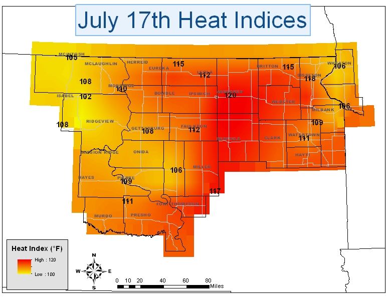
A VERY HOT AND HUMID AIRMASS HAS BEEN STUCK OVER THE
DAKOTAS AND MINNESOTA. FOR MOST LOCATIONS HEAT INDEX
VALUES HAVE TOPPED 100 DEGREES WITH DEWPOINT READINGS
IN THE UPPER 70S AND LOW 80S. BELOW IS A LIST OF THE
HIGHEST HEAT INDEX VALUES RECORDED FOR SELECTED SITES
SUNDAY...MONDAY...TUESDAY
LOCATION SUNDAY HEAT INDEX
ABERDEEN ASOS 120
SISSETON ASOS 118
HURON RAWS 117
DAKOTA LAKES RESEARCH FARM SDSU 115
MARSHALL COUNTY RAWS 115
SAND LAKE RAWS 115
BIG STONE RAWS 113
FAULKTON SDSU 112
LEOLA SDSU 112
FORT PIERRE RAWS 111
WATERTOWN ASOS 111
MOBRIDGE ASOS 110
PIERRE ASOS 109
SOUTH SHORE SDSU 109
BEAR CREEK RAWS 108
GETTYSBURG SDSU 108
GRAND RIVER RAWS 108
HIGHMORE SDSU 106
ORTONVILLE AWOS 106
WHEATON AWOS 106
MCINTOSH SDSU 105
TIMBER LAKE SDSU 102
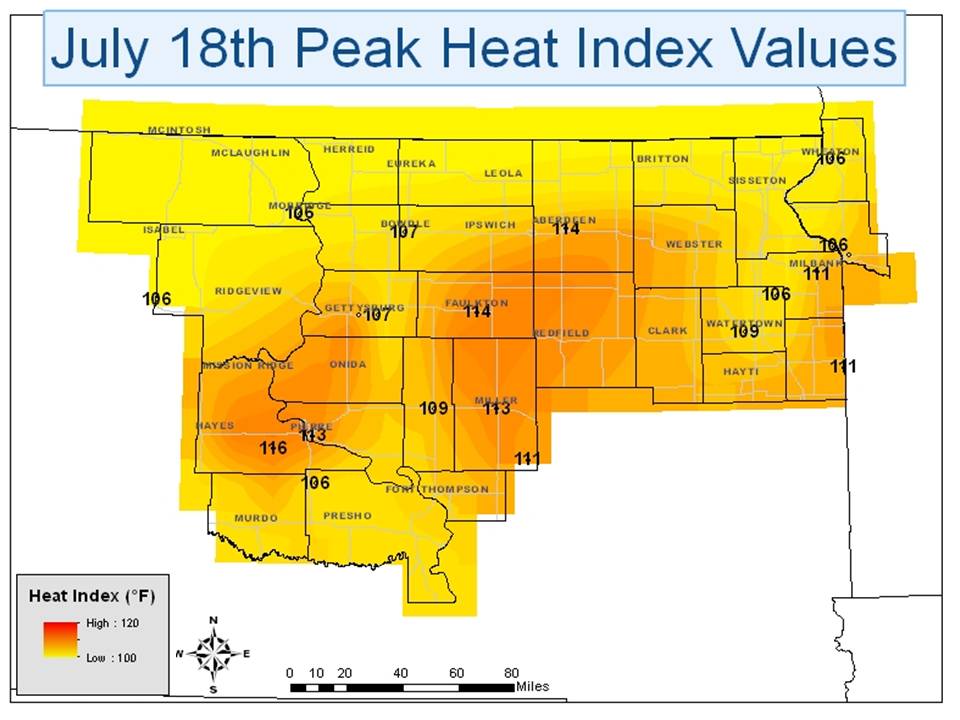
LOCATION MONDAY HEAT INDEX
DAKOTA LAKES RESEARCH FARM SDSU 116
ABERDEEN ASOS 114
FAULKTON SDSU 114
BIG STONE RAWS 113
GETTYSBURG AWOS 113
MILLER AWOS 113
PIERRE ASOS 113
HURON RAWS 111
LAKE COCHRANE SDSU 111
MILBANK AWOS 111
HIGHMORE SDSU 109
WATERTOWN ASOS 109
BOWDLE SDSU 107
GETTYSBURG SDSU 107
BEAR CREEK RAWS 106
FORT PIERRE RAWS 106
MOBRIDGE ASOS 106
ORTONVILLE AWOS 106
SOUTH SHORE SDSU 106
WHEATON AWOS 106
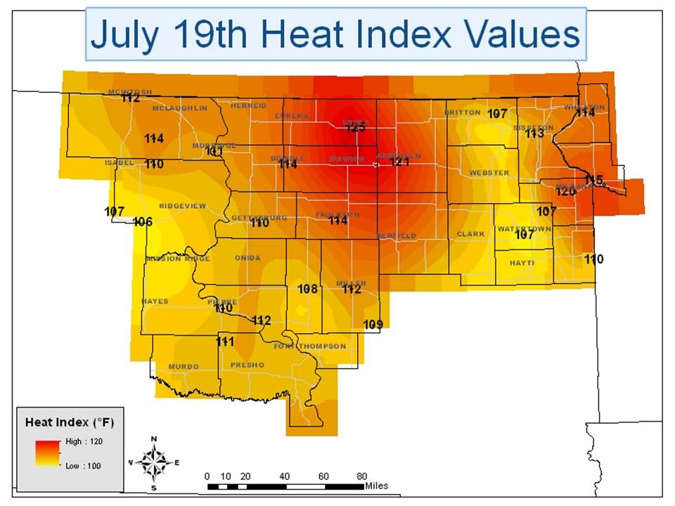
LOCATION TUESDAY HEAT INDEX
LEOLA SDSU 125
ABERDEEN ASOS 121
MILBANK AWOS 120
BIG STONE RAWS 119
ORTONVILLE AWOS 115
BOWDLE SDSU 114
FAULKTON SDSU 114
GRAND RIVER RAWS 114
WHEATON AWOS 114
SISSETON ASOS 113
DAKOTA LAKES RESEARCH FARM SDSU 112
GETTYSBURG AWOS 112
MCINTOSH SDSU 112
MILLER AWOS 112
FORT PIERRE RAWS 111
MOBRIDGE ASOS 111
GETTYSBURG SDSU 110
LAKE COCHRANE RAWS 110
PIERRE ASOS 110
TIMBER LAKE SDSU 110
HURON RAWS 109
HIGHMORE SDSU 108
BEAR CREEK RAWS 107
MARSHALL COUNTY RAWS 107
SOUTH SHORE SDSU 107
WATERTOWN ASOS 107
EAGLE BUTTE SDSU 106

